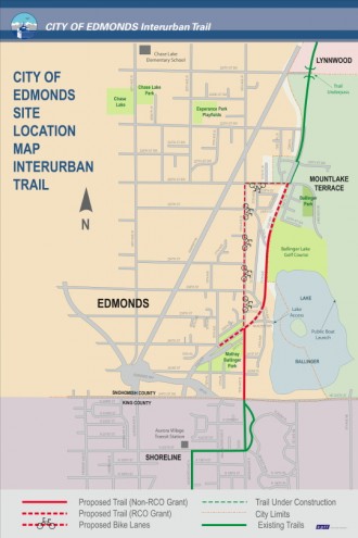
 Interurban North Trail users likely know this spot well. What is a mostly awesome bike route from Seattle to the Shoreline/King County border suddenly ends at a nasty intersection with SR 104 (this is also the point where the street numbers jump 40 streets, then start counting in the opposite direction, which is super confusing to the uninitiated). The trail ends and you are left to bike down a fairly busy 76th Ave W.
But work is about to get underway on the final portion of a trail to connect the existing Mountlake Terrace and Shoreline trail segments. Weather permitting, it could be open as early as the first part of May, My Edmonds News reports:
The Interurban Trail Project will complete the missing Edmonds link of the 30-mile regional trail that runs from North Seattle to Everett. The $2.4 million project — with $1.3 million coming from state and federal grant funds — includes the addition of bicycle lanes on 76th Avenue West both east and westbound.
— Advertisement —
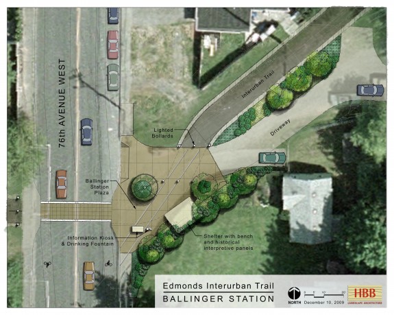
Those who want a more scenic (and slower) route can leave 76th at the PUD crossing and will be able to take a breather at Ballinger Station, a landscaped rest area for users of the Interurban Trail. Highlights will include a drinking fountain, an open shelter with a park bench and two interpretive historical panels that tell the story of the Interurban Trolley Line, which ran from Seattle to Everett until 1939.


Comments
17 responses to “Edmonds trail extention will close key Interurban North missing link”
So, Edmonds is installing bollards while SDOT is removing them?
Not just Edmonds. There are bollards on new trails all over the suburbs. You know how Seattle is 40 years behind Copenhagen? …
On the other hand, I’ve twice encountered SUV nosing around on the Burke-Gilman, both times by gasworks park. They had slowed to a crawl and were trying to extricate themselves, so no direct harm done.
I really don’t like the Interurban that much. Once my wife and I were returning from a camping trip on our tandem. We decided to take a different route home, via the Mukilteo ferry.
Though I hadn’t researched the new route at all, I had assumed we could follow the trail all the way to familiar streets in Seattle. This ended up not being the case: the dearth of signage led us to losing the trail entirely. The trail frequently switched fom roads to separated trails making it hard for someone with no prior knowledge to navigate. I’m pretty sure we were especially confused in Mountlake Terrace, where the signs seemed especially inconsistent. It was a relief to cross into Seattle, where our bike route signs are excellent and improving all the time.
Well, this project aims to fix one of the trail’s most confusing sections, so that’s good news!
A month late, but the area near N 200th St is still confusing. Why couldn’t the trail follow the utility/original interurban ROW from Aurora Village TC all the way across the county line?
I used to commute on the trail regularly. I would only ride the section north of 178th St SW. (Good trail and easy to follow north of that point)
From there I would ride Butternut / Locust Way down to Logboom Park and ride the Burke Gilman.
Much better ride and you don’t have to deal with the patchwork of trails and bike lanes that you mention.
I don’t doubt that wit a good map I could have figured it out. Turns out iPhones are miserable for way finding in urban areas!
A couple things confuse me about this. For one thing, 76th goes north-south, not east-west. Second, I’m pretty sure it (and the relevant stretch of 228th) already has bike lanes! I just rode there a couple weeks ago, maybe my memory is faulty.
The bit of trail next to the golf course and lake will certainly be nice to have. I wonder what kind of land acquisition would be involved in filling in the trail in what I assume is the old interurban right-of-way down to 200th. You’d have to cut down a lot of trees, and the slope would be interesting.
That stretch of 76th (at least as of last fall) did not have bike lanes. However, it did have a very underutilized parking lane that feels a lot like a bike lane (until there is a car parked in it, of course).
From my reading of the full article, it sounds like most of this work has already happened, possibly between when you were last on it and when I was. I vividly remember the 228th bike lane (I remember thinking: “This is a side street! Why paint a bike lane in the door zone?!?”). 76th is a little foggier, but I seem to recall being annoyed at one of the “bike lane ends” signs as I approached 205th/244th from the north. (My annoyance at signage that doesn’t really give helpful guidance to cyclists is outside the scope of this post).
Anyway, it sounds like the bit left to do is the southern end of the new trail section (the part with the lighted bollards and informational kiosks).
The bike lanes on 76th and 228th are both new, and appeared at about the same time as construction on the new segment of trail started. I assumed they were related projects, but either way, the ride is a lot better there now than it used to be. They took away parking on half of the road (it alternates a couple of times on which side of the road that parking is allowed on) and used the freed up space to paint in some bike lanes.
It’s about time. I’ve ridden the whole length of the trail and this section unquestionable sux. I mean horrible. There are no signs or nothing and one is left scratching his head. I don’t care if they actually put a trail through here or not — just give us some damn signs.
Udder dan dat — this trail is exactly what you’d expect riding through a major metropolitan area; discontinuous. Both the cities of Everett and Seattle have done a nice job marking the trail and investing in it. Edmonds and Shoreline should be ashamed of themselves.
From my fairly recent experience on the Aurora Transit hub to Zoo-ish stretch, the Shoreline part is pretty seamless and much nicer than the Seattle part south of the end of the Interurban Trail.
I came on it from north to south. Just before Lake Berringer (sp?) it just basically comes to a dead end and i just guessed where it was and piked it up about a mile down on the back roads.
[…] Shoreline’s investments in the trail in 2011 and Edmonds’s extension that is almost ready to open, much of Seattle’s leg of the Interurban is starting to look […]