This is the second post in a series analyzing Seattle’s draft Bicycle Master Plan update, which is currently taking public comments. This post will focus on the central neighborhoods south of the Ship Canal and north of I-90. Stay tuned for future posts looking at other parts of the city.
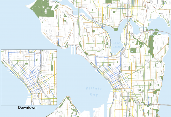
Central Seattle is, not surprisingly, home to a huge number of people who commute, run errands and otherwise get around town on bikes. In fact, a recent customer survey found that more people bike to shop and eat on Capitol Hill than drive alone. A stunning 67 percent of customers walk there.
A strong culture of biking among residents in the dense central neighborhoods combined with the region’s biggest employment center (downtown) combine to create immense potential for safe, inviting bicycle facilities. But these factors also make bicycle facilities more difficult and, likely, more expensive to implement than in other parts of the city.
In general, the Bike Master Plan draft has focused on cycle tracks as the primary way to improve cycling options. Due to the multi-modal nature of the streets and clear evidence that conventional painted bike lanes are not adequate on busy, dense roads (see: 2nd Avenue’s failed bike lane), the plan is spot-on in calling for a network of cycle tracks to connect popular destinations to nearby neighborhoods and both city-wide and regional bike routes.
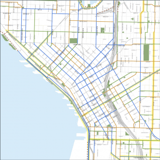 Downtown’s options will be studied further in a center city mobility study funded by the 2013-14 budget. The first cycle track downtown is very likely to be on 7th Ave connecting Dexter to Pike St.
One of the biggest pieces missing in all of central Seattle is a cycle track on Pike and/or Pine Streets east of downtown. Pike Street does not have any recommended facilities east of Melrose, which is a huge oversight. Many people already choose Pike over Pine due to its easier grade and multitude of destinations.
The Pike/Pine corridor is among the most important cycling corridors in the city, and it is also among the most dangerous. As we have discussed before, there is massive potential for improvements. We recommend adding a cycle track on Pike from downtown to Madison (also potential to connect to the proposed 16th/17th/18th Ave neighborhood greenway). The exact details of an improved Pike/Pine will need to be figured out during the engineering process for such a project, but both streets need to be part of that process (Pike may very well turn out to be a better option).
The plan includes several bold choices that few people probably saw coming, such as cycle tracks on Madison St, Boren and Rainier. These are very exciting, and are great examples that the plan is pursuing a bold vision of the future of cycling in Seattle.
Central Seattle Neighborhood Greenways has pointed out that the group’s top priority route connecting Judkins and Volunteer Parks is missing a section between Alder and Columbia Streets. Otherwise, most of the group’s favorite routes are represented or at least approximated (for the sake of the master plan, it’s probably best to consider the neighborhood greenway proposals as approximate corridors. The exact streets used will be worked out during public outreach).
Another huge gap is Jackson St, which needs a cycle track or at least a buffered bike lane. This is complicated by the First Hill Streetcar plans, which did not include bike facilities in their plans for Jackson. This is a huge missed opportunity, as we have written before. There is no comparable corridor to Jackson, which is wide and carries relatively few vehicles per day (14,000, which is fewer than Broadway, though Jackson is a more important transit corridor). The Bike Master Plan should reflect the importance of this street. In fact, a part of me is still hoping a bike facility can be added to the project before it is finished in early 2014. Failure to do so would be a big mistake that will cost us more in money and scars to fix at a later date.
23rd Ave is among the Central District’s most dangerous streets, especially for people walking. Bike facilities also dramatically improve safety for people on foot and in cars. The city received about $5 million in grants to boost repaving work on the street, which is coming in the next couple years. So to see a cycle track included in the BMP for that street is a great sign, and could be an early test of how the plan’s more ambitious elements are handled in real life.
The plan also calls for the 23rd Ave cycle track to extend through Montlake all the way to the bridge. Again, most people who bike have grown so accustomed to thinking of 23rd/24th as a “car street” that it’s easy to forget that cycling there really should be not only be an option, but it should be comfortable. There is no comparable street to 23rd/24th from Montlake to Madison St.
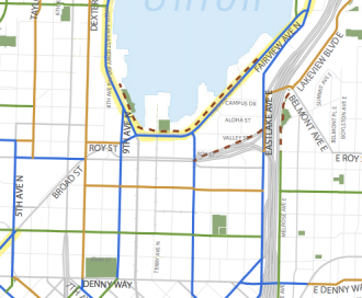 Plans for South Lake Union are completely lacking. Westlake Ave needs improvements, as people continue to ride and fall on the tracks. The problem will not go away until we do something about it. As we have written before, there is precedent for a center-lane cycle track, which would connect well with the planned and funded Westlake Cycle track and the planned and funded 7th Ave cycle track. No bike facility on 9th Ave will ever be good enough to mitigate dangers on the flat, direct and destination-filled Westlake Ave.
Thomas St is supposed to be a “green street” from Eastlake Ave to the Elliott Bay Trail by the time the grid is reconnected to Lower Queen Anne due to the Hwy 99 deep bore tunnel. Previous plans for a reconnected SLU/Queen Anne looked at a cycle track on Thomas and bike lanes Harrison. These plans should be reflected in the Master Plan. If we are not careful, Harrison could become a mean, dangerous, car-dominated street, and bike lanes there would help ensure the street is friendly for biking and walking. Terry Ave was also once discussed as a green street option, but is missing from the plan.
Stewart and Howell Streets are listed as cycle track candidates, which is great. In fact, I would recommend accelerating the Howell St cycle track after 2011’s awful redesign that likely made the street worse for cycling.
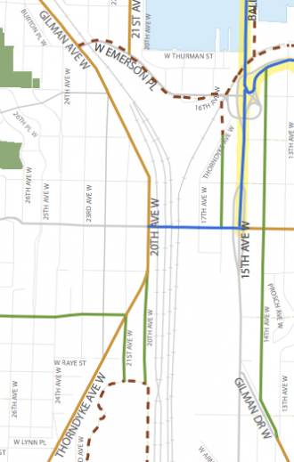 The plan suggests connecting the Ship Canal and Elliott Bay trails via bike lanes on Gilman Ave W and a one-block trail extension from the current Ship Canal Trail terminus on W Emerson Pl to Gilman Ave. Gilman seems like an excellent candidate for a cycle track, since the road currently has bike lanes that work very poorly (for some reason, nearly every vehicle parked there is extra-wide and takes over the bike lane space). Plus, due to the tracks on the east side of the road, a two-way cycle track could work well since there are few cross-streets and driveways (this would also create a trail-like connection between the two well-loved regional trails).
And, yes, the plans call for an improved Ballard Bridge facility. It also suggests cycle tracks on W Dravis and a section of 15th Ave for a fast and safe connection to the future improved crossing.
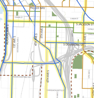 In Sodo, the plans call for cycle tracks on Alaskan Way/E Marginal Way, 1st Ave and Airport Way, along with cycle track connections into downtown along 4th Ave and Seattle Boulevard. We’ll have more on these connections in later posts dealing with south and west Seattle.
Well, there is a lot more that I have not touched on, but this post is already exceedingly long. Are there any key routes missing from the draft map? What do you think of the recommended facilities?
You can also make route suggestions using SDOT’s online BMP update mapping tool.


Comments
25 responses to “Bike Master Plan: Central Seattle and downtown”
It’s a veritable bonanza of lines on a map.
I’m still digesting it, but a couple stand out as “yes, that would be nice, but amazingly hard to implement”: Cycle tracks on Madison and 23rd Ave. Both of these streets are major transit streets that are slated for transit priority improvements, and it will be very hard to make them work with cycle tracks — there’s just a finite amount of room to work with. In Madison in particular, nobody’s come up with a really good way of shoehorning bus lanes in there, and I just don’t see how we can squeeze a cycle track in there too.
Of course, the fact that building these things would be hard doesn’t mean we shouldn’t try, but some of them strike be as being insufficiently thought through.
23rd is well below the threshold for a road diet. A cycle track with bus islands would not necessarily impact transit service and would still allow in-lane stops. In fact, it would make it more comfortable to access bus stops, which would likely have a positive impact on ridership.
I get frustrated when access to bus stops is left out of the equation for transit efficiency. This is a mistake Metro makes all the time. If I can cross the street within a block of the stop instead of walking four blocks out of the way to cross at a light, then that is good for transit.
As for Madison, it only has 22,000 vehicles per day, just barely above the threshold where road diets have a recognizable impact on traffic flow. Bus lanes or a cycle track fits easily. Both? We’ll see what engineers can figure out.
I too have only looked at this a little, but I have a lot of experience w/ the N-S correidor in East Seattle. I have found 24/25th as well as 27th efficient and calm routes that leave me wondering why put resources into 23/24th. It’s noisy and smelly and for some destinations gains too much altitude. That said, descending via 23/24th during off-peak is fantastic.
Why not connect the Elliott Bay and Ship Canal trails with a multi-use path? There’s a dilapidated sidewalk and lots of extra space along the east side of both 20th and Gilman. With this new “missing link” finished, this could become a very well-used recreational corridor.
Imagine… downtown to Marymoor via the Elliott Bay, Ship Canal, Burke-Gilman, and Sammamish River trails, all connecting end-to-end. Pave the E. Lake Sammamish trail to Issaquah, finish the I90 trail, and we’d have one of the longest and most scenic urban trail loops in the country. That would be pretty awesome.
A two-way cycle track on Gilman would feel like a trail and would be a lot cheaper. However, if the budget is there for a trail, that would be great, too. The road could use a redesign for the sake of walking and driving safety (it’s very wide but only 6,400 vehicles use it per day), so the cycle track could also address this issue.
But yes, I think we’re on the same page about how great that connection could be.
Wishful thinking: connect it to the narrow 20th Ave W bridge for an (almost) all-trail connection (or at least shortcut) to the Ballard Locks and Golden Gardens as well.
add a fenced paved path from Rattlesnake lake to Landsburg dam on the old RR grade and you’d have a loop that takes you back to Maple Valley & Renton to the Lake Washington trail. Connect the Cedar river trail to the Soos Creek trail and now you’re connected to Lake Meridian.. extend that to Green River Community College and you’re really talking.
Nice summary Tom! One easily-overlooked detail that the plan update has captured which I think is worth calling out is the connection between the Ship Canal Trail and Thorndyke Ave W. I used to ride to Fremont from Downtown via the Elliot Bay Trail on a semi-regular basis, so I am particularly familiar with the area. In the route’s current state, a cyclist riding northbound on the Eliott Bay Trail is dropped onto Gilman Ave W near the Dravus St Bridge, and then continues on the shoulder of Gilman up to Emerson, where he or she would cross over the BNSF tracks and head down Emerson towards the new Ship Canal Trail extension. A cycle track on Gilman’s west side would indeed improve the route dramatically, but there is a much flatter and shorter alternative:
If, instead of continuing your Fremont-bound trip on Gilman, you turn right on Dravus and cross the bridge, turn left on Thorndyke, follow Thorndyke to its dead end underneath the Emerson Overpass, then navigate a single-track trail that cuts across a gravel utility easement and connects to the newly extended Ship Canal Trail, you’ve just saved yourself a big hill-climb up Gilman and quite a bit of unnecessary distance. This shortcut saved me so much time and effort that I grew accustomed to using it despite the difficult left turn off of Dravus and the muddy single-track between Thorndyke the the Ship Canal Trail. Bike lanes on Dravus as shown on the plans would help immensely, but a Ship Canal Trail connection at the end of Thorndyke seems like *very* low hanging fruit since last year’s extension got the trail most of the way there, and the land necessary for the connection is all public right-of-way. Save for a small amount of shoring that might be required where a new path would meet the current Ship Canal Trail, the project seems like it would be an early win for Interbay as the neighborhood grows, as well as for folks looking for a quick, easy route between downtown Seattle and Fremont, or anywhere in between.
Has anyone else wished for this connection?
Though I’m not sure it really fits the geographic focus of this post (central and downtown Seattle), yes, that would be a nice connection to have. Particularly southbound, where the turn at Dravus is a right instead of a left. A short north-side cycletrack on the Dravus St. Bridge could basically fix that problem (there’s probably room even without cutting traffic lanes — the right lanes in each direction are super wide).
Wow. Never knew you could do that. I’ll have to try it, from looking at a Google Maps photo it looks like the gravel extension is on the east side of the tracks and the Ship Canal trail is on the west side. I’ll have to check it out. I actually like the climb up Gilman with the wide road, but wouldn’t mind losing the W Emerson ride over the tracks and then down the hill past Fishermans Terminal.
I’ve wished for this extension for a long time. I was frankly quite surprised it wasn’t in the plans for the project recently completed.
This would be awesome! When I commute in from Everett I pass through Fremont and use the Ship Canal Trail on my way to downtown. This will save me a ton of time.
How bad is that left turn?
Great idea! The Interbay Neighborhood Association has noticed the missing link between their neighborhood along Dravus and the Ship Canal Trail. They have a blog post about their efforts to extend it.
http://our-interbay.org/2012/02/07/so-close-and-yet-so-far/
I’d love to see the Broadway cycle track, which should be extended to Aloha, feed onto a green street on Federal Ave that goes down and across the to-be-built new 520 lid to the Portage Bay neighborhood.
Federal Ave is a total disaster at the moment by bike — potholes inside of potholes — so this would not be a minor investment.
yeah but the road fix could be sold under the “fix the potholes for cars” budget instead of “add more bicycle facilities” which means it might get actual funding without a fight.
SDOT’s priority for street repair is largely based on traffic volume. Until that changes it will be hard to find the money to repave Federal.
There’s a lot of super exciting stuff happening in the new BMP but as far as I can tell nothing about intersection design. I asked SDOT’s Kevin O’Neill about it at the last BMP meeting and he said they’re still working on it. I made my pitch for Dutch-style intersections (see here and here) and I got the impression it was news to him. I think if you get the intersections right the rest follows, but if you get them wrong it screws everything up. (Aren’t most cyclists killed in intersections?)
I also pitched SDOT’s Dongho Chang on a Westlake cycle track. He pointed out they have it planned a street over on 9th, but I said with the density in that area, and how much development will be there in a few years, why not both? It’s not like we leave one street gravel because the next street over is paved.
That’s a great point. There needs to be a provision that in the stated goals or the plan that when a bike lane is created, the intersections cannot be skipped. Today, this is exactly what happens: Bike lanes are painted in between intersections, then disappear. That still counts as x miles installed, but it leaves unfinished intersections all over the city.
Here is an example, at SW Alaska St and 42nd Ave SW, approaching the Alaska Junction at California: http://www.facebook.com/media/set/?set=a.490344324343096.113894.475747459136116&type=1
I attended the Freight Advisory Board meeting yesterday. In West Seattle, we need to work with the Port, SODO and Duwamish industrial areas to get off the peninsula, so we need to work with them on common interests. Kevin O’Neill presented the status of the BMP Update for SDOT, noting that his group’s next assignment will be the Freight Master Plan. The flavor of the presentation was a bit different than those to the Bike Advisory Board and community workshops. More emphasis on inviting public input to remove lines from the draft map rather than to add lines. Especially on major truck streets. which happen to include most of the big diagonal arterials that, he acknowledged, do not have parallel alternatives. Like Madison, Rainier, MLK, Fauntleroy. So, it would be good to consider that overlay as well as street cars, buses, light rail, etc. Can we persuade the truckers that a bike beside them, safely separated, is better than a car in front of them slowing them down?
[…] our post last week about Central Seattle and Downtown, we move north to the northwest section of the city (for the […]
[…] draft Bicycle Master Plan map suggests 23rd Ave as a potential candidate for a protected bike facility. While the BMP has not been finalized or adopted yet, I personally endorse the idea strongly. There […]
[…] general, the updated Bike Master Plan includes a lot of bold and smart projects. We noted many in our analysis of the first draft. This post focuses mainly on the changes between […]
[…] general, the updated Bike Master Plan includes a lot of bold and smart projects. We noted many in our analysis of the first draft. This post focuses mainly on the changes between […]
[…] general, the updated Bike Master Plan includes a lot of bold and smart projects. We noted many in our analysis of the first draft. This post focuses mainly on the changes between […]