EDITOR’S NOTE: This guest post from Seattle Neighborhood Greenways was a collaboration by several biking parents with the help of SNG staff. It may be inconvenient for city leaders to hear, but disconnected safe bike route islands do not make Seattle a great bike city. If you are not willing or able to bike in busy traffic, Seattle is leaving you behind. But it doesn’t have to be this way.

Biking in Seattle today requires skill and bravery. For someone new to biking, not comfortable jockeying with fast moving traffic, or trying to bike with their children, finding a safe route to work, the store, or school can be incredibly challenging – if not impossible.
Despite repetition by mainstream media and SDOT (Seattle Department of Transportation), Seattle is not currently a great city to bike in. The myth of greatness is part of what is holding Seattle back, and needs to be put to rest. To help bury this myth, let’s hear from mothers and fathers trying to bike with their families in Seattle.
Who is Shirley Savel?
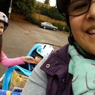
 Shirley Savel is a mom from the Rainier Valley and bikes daily with her 12-year-old daughter and two-year-old son. She blogs about about biking with her family and shares her experiences:
“Sure, we bike because it can be fun, healthy, and we need to get places, but more importantly it’s an economic necessity for our family. During two very rough periods of unemployment, rather than paying bus or train fare we biked. Biking saved my family from homelessness. Even after finding work, biking has remained an integral part of balancing our family budget.
“After close to ten years biking in Seattle I am getting tired finding real viable bike connections to get me from place to place. I can now say that I have lived here long enough to see slow progress/process. In SE Seattle nothing connects. How do I get to places like the library, doctor, grocery store, dentist? No routes connect me to anything. I live in a void.
“When I bike home from North Seattle I follow the Central Area Neighborhood Greenway south but don’t bike to the end because I value my life. I choose the greenway because it has all the elements I love in a slow street: speed humps, flashing beacons, low grade roads and all around less cars.
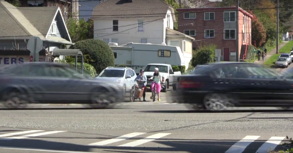
“SDOT has a way of ending this. It ends in a protected bike lane to Franklin High School and the Light Rail Station. Ha-ha, just kidding. It dumps you right into Rainier Ave. THE MOST DANGEROUS ROAD IN SEATTLE. I made this 53 second video to show you.”
A Dad and His Data

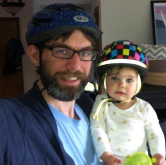
Shirley’s lived experience is not unique. Families across Seattle face similar obstacles. To validate his experiences with data, Tim Fliss created a map showing the routes that families have available to them.
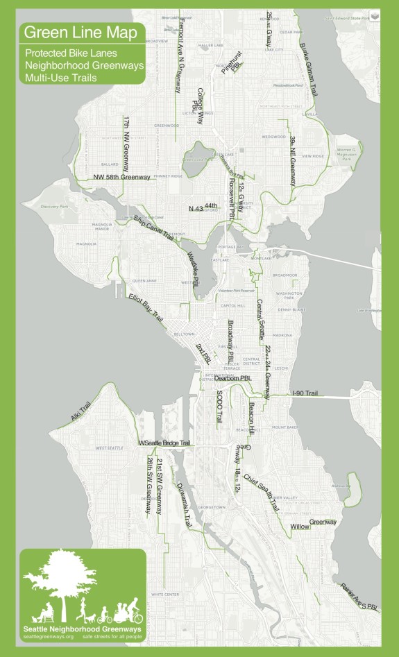
Tim’s map below shows all the routes that SDOT has completed (or will complete by the end of 2016). The green lines are routes that, generally speaking, are comfortable for families: neighborhood greenways, trails, and protected bike lanes. The red lines are routes that are almost always stressful for families such as sharrows on busy streets and door zone bike lanes.
Having trouble seeing the map? Click here to view it directly.
What happens when you remove the red lines, and leave routes that are comfortable for families and people of all ages and abilities? You’re left with stranded lines scattered throughout the city. You’re left with stranded families like Shirley’s and Tim’s. It’s time for Seattle to own the fact that we are not yet a great city to bike in.
All families should be able to get around Seattle on a network of safe streets. To get there we must be honest with ourselves about our current situation, and work hard to improve the lackluster bicycle implementation plan. Stay tuned for part two of this series that will lay out how to build a network that families can use into the bicycle implementation plan.


Comments
35 responses to “Guest post: Seattle’s stranded biking families”
Thanks for this post! I hope city leaders understand how much work they still have to complete even to complete a skeleton of a connected bike network.
Even if SDOT is right that coordinating multiple city center plans requires a delay on those projects, what’s the excuse for delaying Neighborhood Greenways?
Greenways are quick and inexpensive projects. They’re not millions per mile for pavement, signals, etc.
Greenway improvements are mostly things that should be done on residential streets anyway, even without an official Greenway designation — safe sidewalks and crossings, reasonable speed limits, reductions in cut-through driving.
Worst case scenario, a Greenway goes in, then a revised transit plan determines that a bus needs to use part of that route — maybe the bus route will require a few diverters to be removed, a rerouting of some part of the Greenway, or some signal adjustments. But most of the improvements for a Greenway also improve the street as a bus route, since passengers need to be able to get to the bus stop on foot.
Surely Greenways outside the downtown core should proceed TODAY even if more expensive infrastructure in heavily-used areas needs more coordination?
Sadly on point. My household isn’t included in the classic interpretation of “family” because we don’t have children living in our home but we experience all of these things. This impacts everyone, and as long as sdot remains steadfast in thier mission of miles and miles of car parking and focuses on keeping cars going fast over the safety and liveability of an ever increasing urban area, this is all we’ll keep getting.
You are completely right: it affects everyone. I hope by examining the issue through the eyes of two families we didn’t give the impression of ignoring people without kids or in other situations. For the record, I don’t have children. Thanks for your comment.
Excellent post! City spends hundreds of millions a year on streets for cars, trucks and buses. We need to spend way more on biking infrastructure ASAP. We will have safer, healthier families and better air quality. the ROI is undeniable.
This is important. The (painted) bike lanes fizzle on 1st, 4th and 6th as one approaches Denny from the south, so I can’t wait for the 2nd Ave extension from Pike to Denny where once again will give us no protected place to go. (Truth to tell, I told GordonofSeattle that this was a reasonable solution to the vexing Uptown and Seattle Center problems, but still). Third Avenue is supposed to be reserved for busses and intrepid folks on bicycles, but it dead ends at Denny. Even they have no where to go heading north. Fifth runs the wrong way for now while I have a hard time getting to out of the way 9th or Westlake. Connectivity and Intersections should be our war cries!
Going north from downtown to 9th, I’ve given up on the central grid and just take Western to Blanchard, then L on 8th, right on Bell which becomes 9th. I hadn’t known till a tip from Zach Shaner that Bell is two way on that single block. All around this route saves me a lot of stress and danger compared to 2nd/Pike/8th.
Not as direct, but when 2nd Ave protected lane reaches Seattle Center, you can go through Seattle Center to the new Mercer 2 way lane, then to Dexter or SLU. Kinda meh, but if you’re in Belltown, maybe a nicer route north for you.
2 things about SE Seattle biking:
1. The Greenway route the city selected is a routing disaster. The approach seems to have been to choose a route that is already mostly car free at the cost of everything else – convenience, directionality, and servicing places that people biking for transport need – light rail stops, bus stops, etc. The route veers, twists, and turns, never going more than 2 blocks without a chicane, double-turn, 90 degree turn, etc. This makes the safety features of the Greenway less effective, not to mention making the whole experience un-intuitive and more likely to result in losing the route.
2. The Bow-Tie solution to the MLK Way / Rainier Ave S intersection is a critical dependency for making all of SE Seattle safer for commuters of all types. The intersection effectively takes a natural, low-grade focal point and turns it into a hostile wasteland that barely admits of the possibility of improvement. Fix the Bow-Tie, set up signals, channelization, etc. downstream from the intersection to encourage flow, and you can start to fix problems like the the abrupt end to the CD Greenway, the terrible routing of the SE Greenway, and the many unsafe crossings of Rainier Ave S (again, the most dangerous road in Seattle).
“The myth of greatness is part of what is holding Seattle back, and needs to be put to rest”
Thank you for stating this! I think it was just about a year ago that Seattle got some silly silver or gold star rating form a national organization for something about bicycling. What a myth indeed! This is a very hard city for even hardened, fit, strong, and young cyclists, let alone all the real people. I appreciate this perspective.
Great article. I really agree with “The myth of greatness is part of what is holding Seattle back, and needs to be put to rest.”
The situation is actually more dire than the Green Line Map shows. Many neighborhood streets are great for biking, but then inevitably cross an arterial like 15th Ave NW that I could not get across last week (as an experienced biker). We need bike routes, not disjoint chunks of bike lanes and sharrows.
Seattle is a dangerous city for bicycling even if you are experienced. I feel safer in almost every other city I go to. This is not a great bicycling city, it should be renamed, “suicide city.” I have seen to much and had too many close calls to like bicycling here and I usually ride a Mountain style bike in the city limits so that I can take alternate routes on sidewalks or whatever it takes to avoid dangerous trafic. I go the long way if that is safer. I might have to bump up and down of curbs but whatever works. That would be extra difficult if you were pulling a trailer. Seattle is no where near deserving of any awards for great bicycling.
I couldn’t agree more. I’m actually too terrified to ride in many parts of the city. The Ballard Bridge is case in point. That said, I can get to Ballard by taking the South Ship Canal Trail to the Burke Gilman and head west to Ballard. But this is a long-about route and we should be able to cross the Ballard Bridge without fear of losing our lives.
We’re just too damned car centric.
Part of the challenge is that Seattle is really one of the safest cycling cities in the U.S. according to collision and fatality statistics. It’s hard to convince politicians that there’s a crisis when the numbers say the city is so much safer than Portland or Chicago.
But comfort and safety aren’t at all the same thing. Narrow, congested streets make Seattle stressful even while they hold down average speeds and reduce collision severity. You can see that in car statistics, too — much safer for drivers, but more minor scrapes driving up insurance costs.
I suspect framing the issue around safety will have more difficulty than focusing on comfort, equity, and popularity among city voters and taxpayers.
What a great article. The fundamental problem is that despite a lot of lip service and hot air, the Seattle City government has not committed itself building a safe bike network. It is just one of a bunch of competing and sometimes conflicting priorities which means it rarely gets accomplished in locations where it is hard.
To underscore the starkness, I’d love to see the last map w/o any roads (just the green lines and land masses)
i have only biked in seattle a few times. has the city ever recieved plans from a group (a website to view) to establish a route system….perhaps with signage indicating difficulty or danger level and and naming with the anchor points. ie…interloken to 18th or whatever, using quiet neighborhood streets maybe withn a block or so of busier streets where safeways, walgreens and restaraunts may be.
Thanks for this. I couldn’t agree more. And tim: great job with the map. That really drives home the lack of connectivity. I really hope city officials are reading this.
I don’t think Seattle is a great cycling city, but its not terrible, either. I bike everywhere I go, and in most of Seattle you can find a safe route just by looking at a map for a few seconds. (Following designated bike routes is not often the best choice, though. The 2nd Ave bike lanes is one of the pointless things I’very ever seen.)
This is the kind of crap that leaves me hoping for ISIS to take out the Saudi royal family, seize their oil fields, blow up the refineries, and jack the price of our gas up to $10/gallon. Americans need a big, hard, long-term gas shock to reform their behavior as drivers. Seattle and many other cities would be GREAT for cycling–if drivers once again became human.
I bike with my son throughout the city … trying to minimize car use. I am fortunate to live near the Burke-Gilman but the lack of connected bike routes outside of that central spine is really frustrating. In particular traversing Ballard northward is treacherous because of multi-lane arterials like Leary, Market and 15th with few crossings.
I would spend more time visiting central and south Seattle with him if I didn’t feel like I was taking risks traversing downtown, Jackson St., Beacon Ave and Rainier. And I hate ascending Capitol Hill via the door zone bike lane on 10th, feel like that’s another collision waiting to happen. Finally access to many important areas of the waterfront like the sculpture garden or ferry terminals is via busy streets. There is plenty of room for bike lanes on Alaskan way and under the viaduct, I have no idea why I’m dodging cars down there.
I could go on and on, just look at the important destinations on the map and how few are reachable from the existing infrastructure. Over the years I’ve built up a mental map of side streets, less harrowing bike lanes, crosswalks with signals to cross arterials, etc. in part by participating in Kidical Mass, but new cyclists who are not initiated into this secret, hidden bike network are going to be frustrated, confused and intimidated.
I am a strong and confident cyclist, but basically, I have a comfort zone around the B-G where I just hop on and go; outside of that area, I carefully plan routes to minimize risk. Sometimes I just give up and choose transit or car instead. Having a connected and safe route from north to south Seattle, and east/west through the center city, would make a huge difference and create a connected city for biking families.
Thank you. I’m tired of bike lanes and now Greenways that simply end at some impossible high-traffic non-destination. Seattle is not (YET?) a world-class city for biking.
If a bike route suddenly ends without a connection to another one, it makes most of that route useless for many people.
I can see how the planners are stumped at certain intersections and then just give up but they need to try to make something work at spots that are hard to make work. I’ve seen in some cities how a bike route ends in a very weird way. After looking at it I realized that, while odd, it was necessary to do install something to make the connection to another route rather than no connection at all. I appreciate the effort and I find it’s useful.
The way the BMP Implementation Plan is laid out points to a big part of the problem, which is that bike plans are made in a department-centric way, not a bike-centric way. For example: want to ride to downtown from the I-90 trail? Great, the Dearborn Cycletrack should help… except that it ends where the route departs Dearborn Street instead of continuing where it needs to go! Prior to that the city set up a “Hiawatha Greenway” project, deliberately leaving the most critical part of the route (crossing Rainier) for the Dearborn project. It’s all one route, y’all!
The Westlake Cycletrack is much the same, ending (into narrow, goofy park paths) at a random park boundary… and even the project intended to continue the route south from there (a cycletrack along 9th Ave N) doesn’t make it all the way downtown, only because all the streets change at Denny. The bike lane under construction on Roosevelt will make it as far as the bridge, but no farther, though a bridge is not really much of a destination, and it will be a one-way route, ignoring the street’s northbound counterpart (with no plan to address it within current planning horizons), though most people riding somewhere will want to ride back afterward!
And these are actually improvements compared to the long history of, “What can we fit on which blocks?” planning evident on streets like 15th Ave S. But then that stuff rears its ugly head again on Banner Way.
(And I have nothing against opportunistic cycling work — when an opportunity arises, of course, take it! But having a bike master plan and cycling-specific funding buckets means that when work is done under these labels, it must be done with the clear, top-line goal of creating excellent, useful, complete bike routes.)
I don’t dare bike Downtown to go to work. I’d prefer to live. Too damned dangerous, the bus/trolly line divots, the car drivers who barely tolerate walkers much less someone on a bike, the buses and truckers clashing for space.
[…] more harm than good. That’s the message in a sober post by Seattle Neighborhood Greenways on Seattle Bike Blog. Biking in Seattle is not easy for most people because its safe bike routes are disconnected. One […]
[…] In Part 1 of our story, we left Tim wondering how to commute by bike with his baby daughter and left Shirley stranded with her children trying to cross Seattle’s most dangerous street, Rainier Ave S. In Part 2, we explain how to rescue them. […]
Here is part 2: http://www.seattlebikeblog.com/2016/05/13/guest-post-part-ii-how-seattle-can-rescue-residents-stranded-by-an-incomplete-bike-network/
Informative piece – I was enlightened by the points . Does someone know where my business can acquire a blank IRS 2106-EZ copy to complete ?
its interisting…please read the article about integral waterproofing http://www.ahlibeton.co.id/2015/09/waterproofing-integral.html
First of all Thanks for this post! I am very interested in reading part two of this series
where I can find “how to build a network that families can use into the bicycle implementation plan” ?
http://www.seattlebikeblog.com/2016/05/13/guest-post-part-ii-how-seattle-can-rescue-residents-stranded-by-an-incomplete-bike-network/
[…] a guest post today on Seattle Bike Blog, Gordon Padelford of Seattle Neighborhood Greenways quotes Shirley Savel, a […]
Awesome post!I have read the whole post and learned a lot about bike settleing.