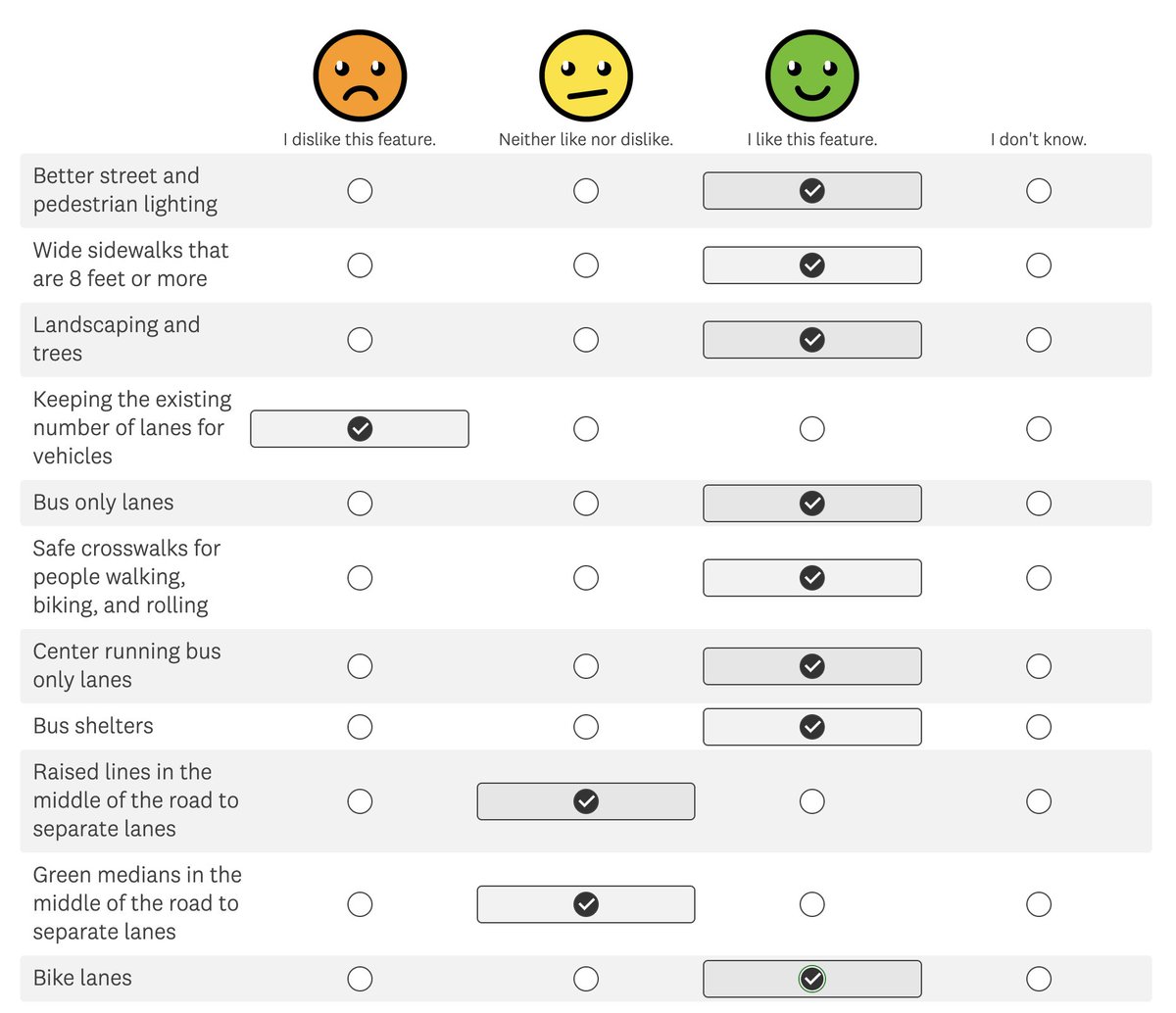
Public comment closes today (April 12) on early concepts for the future of Aurora Avenue N, the most dangerous street in the city.
The good news is that the city is considering some very ambitious ideas for the city-managed state highway, including protected bike lanes and center-running rapid bus lanes. The less good news is that the concepts at this point seem to pit bold transit improvements against bike safety.
But it’s still early, so this is the time to make it clear that there is a lot of support for a future Aurora Avenue that prioritizes biking, walking and transit to foster a safe and inviting neighborhood commercial boulevard. The city’s growth plans call for even more housing along this street. It needs to be so much more than a half-baked wannabe freeway.
UPDATE 4/16: SDOT has shaved a day off the start of the trail closure, saying, “We realized we could accomplish the work planned that day without closing the bridge until April 20.” We have updated this post accordingly.
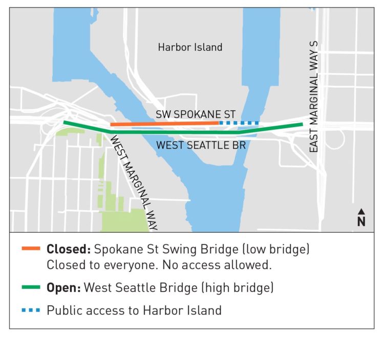
The walking and biking trail on the Spokane Street Bridge will be closed April 20–28, and SDOT will not be building a safe bike route through SoDo like they did in January 2023. Instead, the city is offering a free daily round trip ticket on the bus or West Seattle Water Taxi.
The closure is part of a larger project to reroute the wiring for the swing bridge controls under the Duwamish River rather than along the high bridge. When the bridge will be inoperable due to scheduled maintenance, maritime travel gets priority so the city must leave it swung open. Because the city decided in the 80s to build the upper West Seattle Bridge as a freeway with no biking and walking access (despite significant protests) there is no easy detour option.
Options for people biking boil down to putting your bike on a bus, taking the water taxi, or detouring miles out of the way to the 1st Avenue Bridge. The Duwamish Trail is now fully connected from Spokane Street to the 1st Ave Bridge on the west side of the river, but there is no dedicated bike route on the east side. Anyone biking the detour should be prepared to navigate busy industrial streets. 1st Ave to Spokane Street is probably the least bad option for heading toward downtown via the usual bike route on E Marginal Way north of Spokane Street.
Below are instructions on how to get a free bus or water taxi round trip, which requires a phone and the Transit Go app:
My child attended the truly amazing Pike Market Child Care and Preschool for three years before graduating in summer 2023. We biked there every day together. Navigating the market is second nature to her. She knows all the shortcuts and how to find every store (well, every store with candy, magic, or toys). Her allowance played a major role in propping up the market’s fortune teller machine industry during those tough early pandemic years.
She cried the day that the on-street picnic tables disappeared at the end of summer because that is where we would sit to eat an after school snack every day, whether it was a brownie from Three Girls or those sugar donuts or something from Rotary Grocery. She didn’t understand why they would take away a place where we could eat just so a couple people could park cars. I don’t understand, either.
But then she was so happy when they returned the next spring.
She also loved the rare days that the street was closed to cars because she didn’t need to hold my hand to walk in the street. The lack of cars gave her freedom to move around the market she loves so much without fear. This was a powerful experience for her.
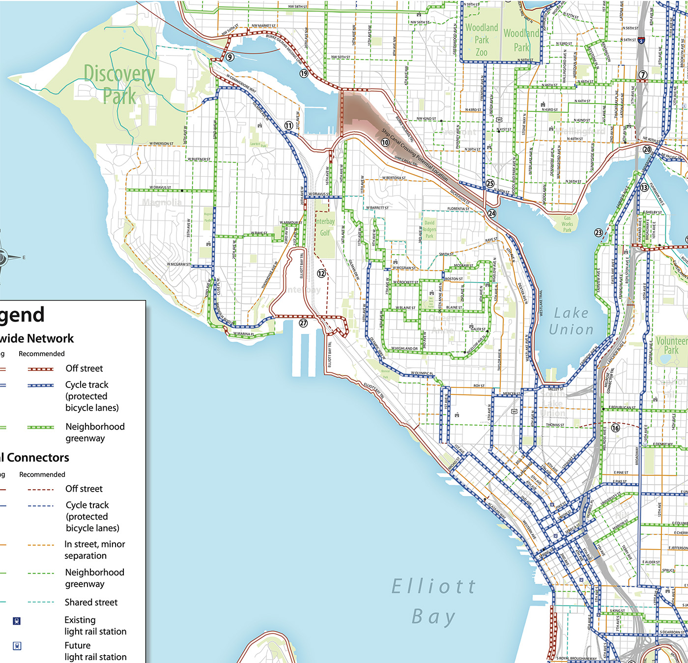
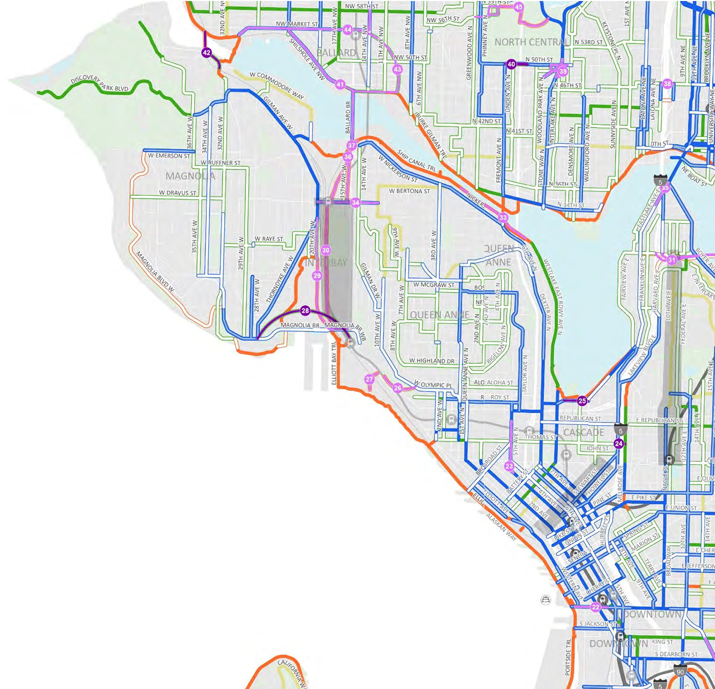
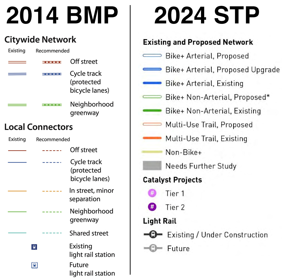
Mayor Bruce Harrell’s proposed Seattle Transportation Plan (“STP”) is now in the hands of the City Council, who can make some final changes before adopting it as official city policy. The STP will supersede the 2014 Bicycle Master Plan, so it’s important to take a close look at its vision for the next 10–20 years of bike improvements across the city. To do so, Seattle Bike Blog will post a series of six stories focusing on different areas of the city. You find other areas as well as other STP-related stories through the 2024 Seattle Transportation Plan tag.
Downtown was one of the stronger areas in the 2014 Bicycle Master Plan. You have to remember that this plan was created before the 2nd Ave bike lane opened in fall 2014, and the idea that Seattle would build a network of protected bike lanes downtown was almost laughable. Even bike advocates were surprised when then-Mayor Ed Murray announced the 2nd Ave project during the Cascade Bicycle Club Bike Month Breakfast that spring, just a couple months after the City Council approved the Bicycle Master Plan. But seeing the 2nd Ave bike lane in action changed everything. It worked so well that much of the resistance to more downtown bike lanes vanished overnight. Before 2nd Ave, everyone assumed that downtown would be the hardest place to build bike lanes. But in reality, it may have been the easiest (not that it was easy).
All this is to say that there are not a ton of changes from the 2014 plan to the mayor’s proposed Seattle Transportation Plan bike map. Perhaps the biggest change is that it doesn’t look as impossibly ambitious as it did in 2014. But there are some really good additions as well as an interesting wishy-washy gray box on Stewart Street. Let’s start with the gray box.
Stewart Street is a diagonal street that makes a connection from Eastlake Ave to the downtown core in a way that no other street does. It is a massive opportunity to decrease travel times for downtown-bound bike trips. Today, biking on Stewart is a very scary experience, but it is so much faster than the alternatives that a lot of people do it anyway. Making Stewart safe for biking would be huge. The gray box is there because the STP includes a capital project to redesign Virginia and Stewart Streets, perhaps making Virginia a two-way transit route. But the details of this are all up in the air still, thus the gray box. But there’s another variable here that is worth noting in the plan: The Center City Connector Streetcar. Despite our arguments against it, the 2014 bike plan cut the proposed Stewart Street bike lanes short to avoid the section of Stewart that the streetcar would use. I argued strongly then that bike lanes were even more important near streetcar tracks. I stand by that today. But that streetcar may never be built, and if it isn’t, then there is no reason not to connect the Stewart Street bike lane all the way to 2nd or even 1st. Imagine a direct bike lane from the REI on Eastlake Ave to Pike Place Market. (Oh, and speaking of Pike Place, tell the City Council not to block funding for efforts to rethink the current state in which streams of confused tourists are allowed to drive their rental SUVs through the middle of our city’s most popular attraction).
Philip Thangsombat has been an editor on other people’s documentaries for 14 years, but “I have always found excuses to not make my own film,” he said during a recent conversation with Seattle Bike Blog. That is until he met Hanoch Yeung.
You may know Yeung better as the person behind Best Side Cycling on YouTube. “I have a lot of admiration for [Yeung] because he is somebody who doesn’t have any video production experience, and yet he started a YouTube channel,” said Thangsombat. Yeung just had a passion for showcasing cycling in King County and figured out the technical stuff as he went. He said Yeung shows that “anyone can do anything,” and that Best Side Cycling “transcends cycling.”
The Best Sides of Cycling premieres 7 p.m. April 16 at SIFF Cinema Uptown. It will be followed by a Q&A with Thangsombat and Yeung. Tickets are sliding scale from $5-$15, and a portion of the proceeds will go to Ampersand Bikes Club.
Thangsombat first found the channel a couple years ago when he decided to give bike riding another chance. He originally learned to bike when he was 25 in New York City, “which was kind of crazy,” but he found himself being fearful and reluctant at the time, so he stopped. “I enjoyed being on a bike, but just was fearful of riding with cars.” When he tried again a few years ago in Seattle, however, he found Best Side Cycling. “Hanoch’s channel just helped ease my anxiety.” He said he would watch a route guide video multiple times before trying it himself. “If I’m on a ride, I recognize it from his videos and so I know what to do.”
Thangsombat also found another community resource: The Ampersand Bikes Club. Riding with ABC is also how he was able to meet the guy behind the videos he’d been watching. Through it all, he was inspired to finally go for it and work on his own documentary film, and he knew who the subject would be.
The Best Sides of Cycling is a tight 20 minutes that is “not a super serious documentary” about “the power of cycling to bring people closer together.” It focuses on Hanoch and how he started the channel. But it’s also about more than that.
“I was really drawn to his relationship with his dad because it’s kind of similar to mine,” said Thangsombat. “So it was kind of like telling my story with my dad through his story.”
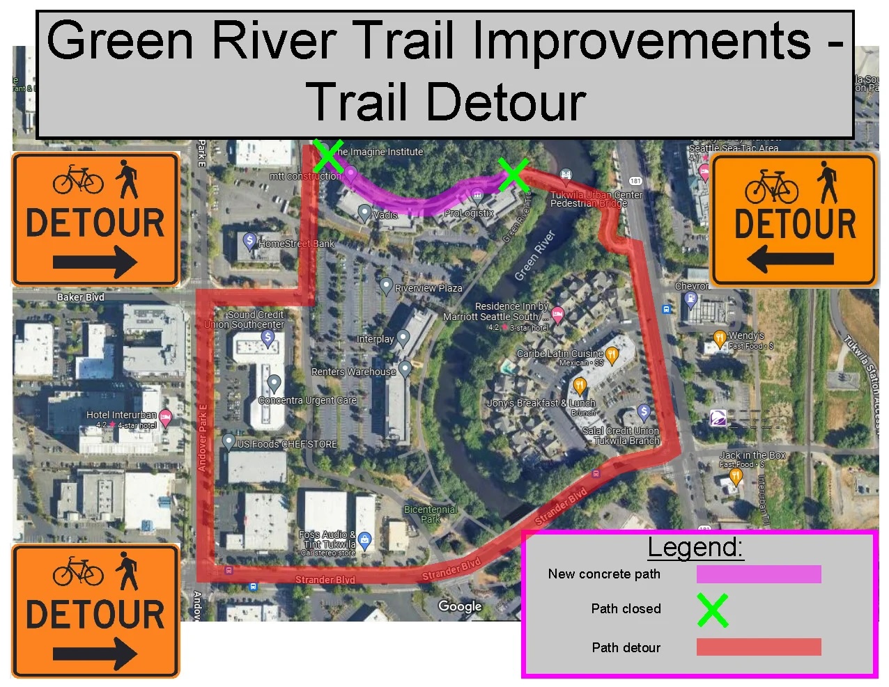
Whether you’re headed across the river or continuing on the trail, you can do better than the official detour.
A 700-foot section of the Green River Trail is getting repaved and upgraded in Tukwila and will be closed April 8 until summer.
The official detour is a bit confusing, routing people onto very busy roads that have no bike lanes and are significantly out of the way. However, there are also parking lots that provide an almost-direct connection around the closure. People will likely be better off not following these detour signs and improvising a route instead.
I don’t know the whole backstory here, but I’m guessing that they can’t sign an official detour route across private parking lots without significant agreements and perhaps also payments. So instead you get this absurd detour route. This also highlights how relying on a single trail rather than building a network of bike routes holds back the true potential for biking in this and many other areas. People need safe routes to get to all the destinations on these busy streets away from the trail, too.
The project includes “700 linear feet of concrete multi-use trail improvements within the right-of-way of the Green River Trail, including but not limited to clearing and tree removal, excavation and embankment, concrete paving, landscaping and irrigation, decorative concrete treatments, and lighting and camera systems,” according to the City of Tukwila.
Meet up in the center of the park at 7ish. Leave at 730. Every Thursday from now until forever rain or shine. Bikes, beers, illegal firepits, nachos, bottlerockets, timetraveling, lollygagging, mechanicals, good times.ShareMastodonTwitterFacebookRedditEmail
Bring your bike (and helmet) for an assessment of its condition for the Spring riding season? Light tune ups will be conducted by our veloteers on hand. Suggested donation $10.ShareMastodonTwitterFacebookRedditEmail
Bike Camano Island for 40th edition of classic ride! The McClinchy Camano Classic Century offers scenic and challenging route options of 103, 65, 50, 35 or 15 miles. Fresh food stops, mechanical support and gourmet[…]
Monthly agendas can be found at: http://www.seattle.gov/seattle-bicycle-advisory-board/meetings/meeting-agendas The Seattle Bicycle Advisory Board (SBAB) advises the Mayor, City Council, and City Departments and Divisions on projects, policies, and programs that improve and/or affect bicycling conditions in[…]