 A cycle track on Thomas St from South Lake Union to Seattle Center could be an option for development, assuming the deep bore tunnel project goes through. Geoffrey Wentlandt of the Department of Planning and Development presented some updated concepts (these are in-process drafts) to the Bicycle Advisory Board (SBAB) last week of what could happen to Thomas and Harrison Streets if the street grid is reconnected south of the proposed Highway 99 portal.
As cyclists, it could be a good exercise to try to work out what sort of facility we would want to connect Lower Queen Anne and Seattle Center to South Lake Union, a corridor that is currently lacking in any good bike routes.
So let’s go into some bizarro future land for a bit and imagine a Seattle where the street grid is connected south of Republican (see map above) and Mercer looks like this as it passes under Aurora:
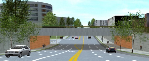
Okay, now there are basically three options presented to you for Harrison and Thomas Streets, a couple blocks south of this proposed seven-lane behemoth of a street that could be Mercer after the Mercer West project is finished.
One: The fast commuter bike lane we’re used to
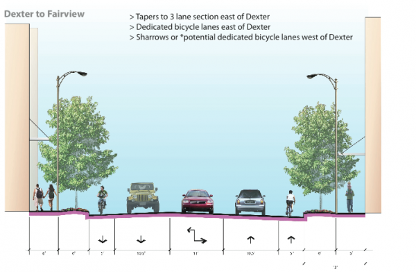 This option would put the standard old five-foot bike lanes in each direction on Harrison. Advantages include speed. Disadvantages include traffic volume. Being the first through street south of the tunnel portal, Harrison will likely be packed with cars.
We may also need to fight a little to continue those bike lanes across Aurora, as DPD has signaled that they want four lanes of general vehicle traffic near the portal. That would look something like this:
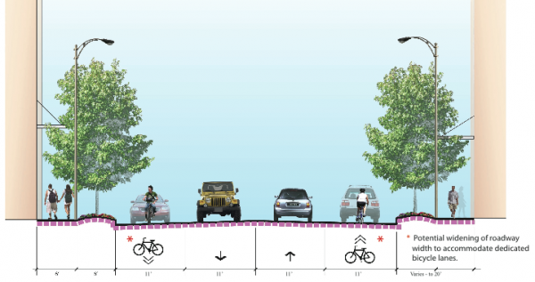 Nope, not going to work. Wentlandt said there may be potential to widen the lanes enough to squeeze some bike lanes on there, but riding a bike in a squeezed bike lane on a busy street where people are trying to enter and exit some crazy car tunnel freeway thing just doesn’t sound like the kind of bicycle facility that is going to get lots of people riding.
Meanwhile, under this concept, Thomas would look something like this:
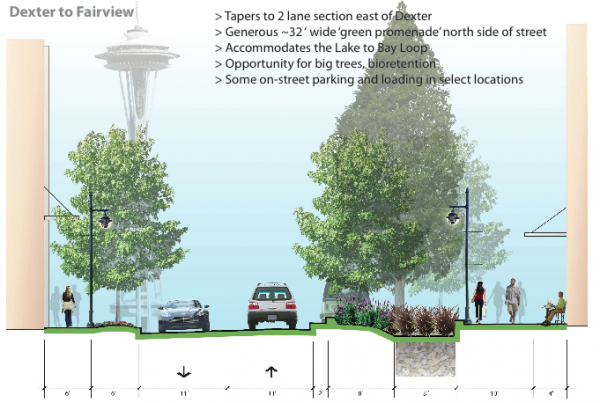 This is the so-called “green street” concept for Thomas. Traffic calming is built into the design from the start, which I like. It has a pedestrian focus, but this street would hopefully be friendly to people riding bikes, as well. There are wide sidewalks, green water runoff systems and more trees and stuff.
Two: A Thomas St cycle track
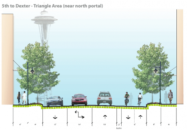 In this image (and the one at the top of the post), you see a concept for a two-way cycle track on Thomas. With this option, plans as they are would basically reserve Harrison for cars and brave bikers only. The cycle track is cool because … well, it’s cool! It is certainly more welcoming to new riders than a five-foot, minimum-width-possible bike lane on a busy street. So what’s the catch?
Well, unless funding for a project like this came from somewhere else, the cycle track would be implemented in conjunction with development. So if a new building goes in on a block, they would have to install the cycle track in front of the building. So we could end up with something like blocks of cycle track here or there but nothing connected for a while. That doesn’t really help. So in order for this plan to work, we would have to fight for funding somehow.
Also, I liked the plants, green runoff and extra pedestrian space in the Thomas St vision in option one. I don’t want to see that stuff go at the expense of a bikeway.
Three (and beyond): Take the Thomas green street further
Since we’re in bizarro future land anyway, let’s stretch things a little further. First off, bike lanes should be on Harrison no matter what plan we go with. It doesn’t need to be an either/or thing. If a person on a bike is trying to get somewhere on Harrison, that person should be able to do so safely. Taking away that bike lane does not seem to have any advantages for anyone.
Second, the cycle track on Thomas is cool-looking and all, but we may not really need it. The plans for the Thomas green street imagine the street as a slower, calmer street. This means through-traffic cars would have to be given some kind of incentive to take Harrison instead of Thomas.
Well, let’s take that idea and run with it. I say, design Thomas to carry no greater than 1,000 cars per day (I just made that number up, the point is: really low) at speeds no greater than 20 mile per hour. Then there is no need for a cycle track. Any bike rider will feel safe riding on that street, including parents with children. This may require speed bumps or even forcing motor vehicles to turn off Thomas at major intersections to prevent through traffic. But the gains in bicycle use and safety would be huge.
Basically, we need a street from South Lake Union to Seattle Center and Queen Anne that, at its core, exists at a walking and biking pace.


Comments
4 responses to “A street between South Lake Union and Queen Anne designed for walking and biking”
One little wrinkle, unless they are planning on changing things only Harrison St has a signal at Dexter Ave N.
The other wrinkle is that Thomas (Dexter – 5th) has commercial entities, parking lot entrances, and parking structure entrances. I don’t know the ADT, but my concern would be that once it’s a connected grid it will almost certainly carry much > 1,000 vehicles per day, probably closer to at least 3,000.
Next generation bike boulevards/neighborhood greenways operate at a comfortable flow for people on bikes because they set 1,000 vpd as the maximum threshold. This means they don’t back up with cars. My comment at the SBAB meeting was that, as shown and described, the “green street” concept for Thomas is a virtual match for many of the local service streets in Portland’s Pearl District (and the presenter responded that he had in fact drawn a lot of the inspiration for the design from streets in the Pearl District). Riding on any of the commercial local service streets in the Pearl – Couch and Davis are good parallels – it’s apparent that while their operating speeds (< 20 mph) encourage biking, the sheer volume of automobile traffic means it's either a) stop-and-go for all users regardless of mode, or b) bikes weaving in and out of stopped automobile traffic/scooting to the front of the intersection using the cushion between idling and parked cars. Neither of these riding situations create exceptional conditions for people on bikes, and I would worry that this is the environment that would be created on Thomas.
[…] Trail by the time the grid is reconnected to Lower Queen Anne due to the Hwy 99 deep bore tunnel. Previous plans for a reconnected SLU/Queen Anne looked at a cycle track on Thomas and bike lanes Harrison. These […]
[…] the state ever finishes the SR-99 deep bore tunnel project, the new highway portal design will reconnect John, Thomas and Harrison Streets between Seattle Center and South Lake Union, further reopening […]