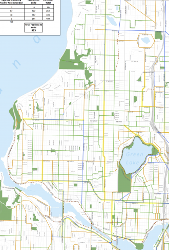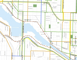
This is the third post in a series analyzing Seattle’s draft Bicycle Master Plan update, which is currently taking public comments. This post will focus on the northwest neighborhoods, north of the Ship Canal and west of Aurora. Stay tuned for future posts looking at other parts of the city.
Following our post last week about Central Seattle and Downtown, we move north to the northwest section of the city (for the sake of this post, this includes NW and some N avenues), which features some of the bikiest neighborhoods in the city as well as neighborhoods with some of the biggest cycling potential.
Fremont may be the capitol of cycling in Seattle. With its prime location at the nexus of the Interurban North bike route and the Burke-Gilman Trail, as many people bike to shop in Fremont as drive alone.
Shoppers in Ballard who live nearby cycle as often as Fremont residents (about 7 percent of total resident shoppers). But 11 percent of non-resident shoppers in Fremont got there by bike, compared to just five percent in Ballard. This suggests that Ballard has equal if not greater potential for cycling as Fremont, but something is preventing the bicycle economy from flourishing. And I think we all know what some of those barriers are.
The two biggest barriers to cycling to Ballard—The Burke-Gilman Missing Link and the Ballard Bridge—are included in the draft Bicycle Master Plan map. But the plan also includes a connected network of neighborhood greenways to help grow the number of Ballard residents who use bikes as an easy and fast way to get around within the neighborhood. I sat down with Jennifer Litowski and Chris Saleeba of Ballard Neighborhood Greenways recently to discuss their hopes for the future of cycling and walking in their neighborhood.
Many of the group’s proposed neighborhood greenway routes are more or less included in the plan, and they say this is a good thing since the routes are the result of a lot of community outreach and local knowledge.
“The work of neighborhood groups can jump in on those decisions, because they have been discussing it with neighbors,” said Litowski. “You know your own neighborhood.”
With money in the 2013-14 budget set aside specifically for Ballard neighborhood greenway projects, the group is hopeful a lot of headway can be made on on connected “box” of greenway routes reaching many key neighborhood destinations.
But while it could be relatively easy to create a network of connected residential routes, the “last block” is still an issue in many places, especially for destinations on commercial drags.
Market Street is marked on the draft map as a candidate for a cycle track, which would be a huge boon for walking and biking safety and access in Ballard’s commercial center.
Conspicuously missing from the northwest area of the map are bike facilities on Leary Way (and N 36th St in Fremont), 15th Ave NW and the Aurora Bridge.
 Leary/N 36th desperately needs a redesign for the sake of safety and business access for people on foot and bike. The Burke-Gilman Trail is a better route for people passing through the area, but anyone who has ever tried to cross the very wide Leary Way on foot in the otherwise walking-friendly Old Ballard area knows, the street is dangerous and uncomfortable. And accessing businesses on N 36th (like Roxy’s Diner or Hub and Bespoke or Fremont Coffee) is difficult on a bike. I strongly suggest this street be added as a cycle track candidate.
15th Ave NW is a terrible barrier for life in Ballard and Crown Hill, where traffic turns onto the awful Holman Rd. For example, when trying to find Grumpy D’s Coffee Shop to meet Litowski and Saleeba, I forgot the cross street for the shop. To bike up and down 15th looking for the shop, I had two unappealing options: Bike uphill in heavy, fast traffic or bike on the sidewalk. For someone trying to cross the road on foot, safe crosswalks sometimes require walking many blocks out of the way just to get to the other side.
A safe Holman Rd is perhaps even more important than 15th, however, because it cuts across the street grid on an angle. Not only are there no parallel roads to use, but the road is very wide and difficult to cross on foot or bike. Its width also makes it a great candidate for a redesign.
Which brings us to Aurora. Unlike 15th/Holman, Aurora is a state highway. But it is also lined with destinations, and it is one of the most dangerous streets in the city no matter the transportation mode you use. While the Interurban North bike route is only a few blocks west of Aurora, many people bike down the sidewalks on Aurora. And yes, it is legal to bike on Aurora.
There is tremendous potential for a bike route on Aurora (at least from the Bridge north). For one, it is the only road that cuts between Woodland Park and the Zoo. The Aurora Bridge is also a much faster and less hilly way to get from upper Fremont to the top of the hill on Dexter. A safe bike facility on Aurora could be a boon to businesses that line the road. In many places, Aurora does not even feel like a part of the neighborhood. A little work to bring a bit of non-motorized transportation to the street could go a long way to healing the rift caused by the road.
Oh, and can we get the Ballard Locks to stay open 24/7?
What do you see in the plan that you like? Anything missing?
UPDATE: The Seattle Bicycle Advisory Board released its NW Bikeability Report today:


Comments
12 responses to “Bike Master Plan: Northwest Seattle – UPDATED”
I’d love to see a Dutch-quality cycle track (with Dutch-quality intersections) on Market. There’s plenty of room for it and there’s a lot to bike to.
Agreed. That’s the coolest part of the plan for the NW, in my opinion. Does anyone know when Market is due for a repaving?
I feel like having a cycle track on the downhill portion when 46th transitions to Market is a bad idea. It’s very steep, enough for unskilled cyclists to hit 30mph easily. Those kinds of speeds are not appropriate for the tight confines of a cycle track. According to me, at least. I’d take the lane the whole way down. I have no issue with the track in Ballard, though.
I think the best way to look at these lines is that we want a facility of equal quality to a cycle track there. The exact details of what goes in and how geographic issues are dealt with (etc…) will be figured out during the design process. But for the sake of the master plan, a cycle track says that we want something high quality that is comfortable for anyone to use.
Indeed. Recall that the Dexter re-design was initially going to be a cycle track, until folks raised some of these same concerns. The result is that SDOT listened, and came up with a design that (in my opinion) works extremely well. That gives me confidence that they can do the right thing on 46th/Market as well!
Oh, excellent. I had planned to go to the meetings, but ended up working during them.
I think something like Dexter could work on the section of street I describe. Thanks for the reply.
Or something like Dexter, but with reflective plastic bollards in the buffered space to give another level of separation. There are many things the city could try.
Hmm. Switching sides of the street could be an issue if you went with a climbing lane on the portion of Market between 55th and 46th. You’d probably have to do some sort of redesign of the weird intersection with 5th and 6th. Perhaps, if the cycle track is on the south side, you could put in a bike-only lane in the middle from 55th to 5th to help ease the transition. Or maybe you could redesign that whole junction; 55th Place sticks out as low-hanging fruit for a connection to the 56th St greenway to Phinney and the zoo. Might be less of an issue if a median cycle track or bike lane is an option.
If it weren’t for that Green Lake Way cycle track (and the overall thorniness of the Aurora interchange), I’d just put normal bike lanes on 46th all the way to Midvale Place and 45th. As is I’d put the 46th cycle track on the north side east of either Fremont or Phinney, for the easiest connection possible to both Green Lake Way and the 46th Street greenway through Wallingford.
I live at the top of the hill in Fremont/Woodland park. In my opinion, the single biggest barrier to accessibility to Ballard between Phinney, Woodland Park, Fremont Hill, Wallingford and Greenlake is the fact that there is no bike infrastructure from N46th st and Phinney down into Ballard (Market st).
46th is an excellent bike route going down at any time of day but it’s scary as hell to ride up it. I’ve done it many times late at night when motor vehicle traffic is not bearing down at 50mph+ and it’s a nice hill, even on a single speed. As effort goes, the best comparison I could make would be Stoneway. Descending into Ballard is a lot like descending the curvy part of Dexter.
As for Traffic patterns on this corridor, I’ve been watching very closely for a long time (I work from my house) and it is certainly not heavy at any time of day until you pass Fremont Ave. and enter a huge bottleneck of I-5 and UW traffic that backs-up throughout Wallingford. SDOT has been focusing on attempting to alleviate the problem locally in Wallingford and around Aurora by removing crosswalks but a more effective approach would be to find a way to calm the traffic flow further back into Ballard.
I’ve been bitching about this flawed design for a long time and I’m glad to see they’ve decided to fix the problem. I’m sure I wasn’t the only one.
Just viewing the map in Scribd looks very blurry, but is that a cycle track on Greenwood north of 100th or so???
And a cycle track on 8th south of 85th petering out at Leary Way. There had better be a high-quality crossing of Leary there; connecting to the Burke will be vital for that corridor.
I hope the green on the 38th St undercrossing of Aurora doesn’t seriously mean they’re going to greenwayize that stretch. And if that map is accurate and they’re seriously considering a separate bike/ped bridge paralleling the Ballard Bridge that empties directly onto the Burke-Gilman and Ship Canal Trails, I’m not sure I see the point considering how often that thing would have to open.
Well, the other option for an additional bridge near the Ballard Bridge would have some very steep approaches to bring it to the level of the existing bridge, which could deter some cyclists.
[…] general, the updated Bike Master Plan includes a lot of bold and smart projects. We noted many in our analysis of the first draft. This post focuses mainly on the changes between […]