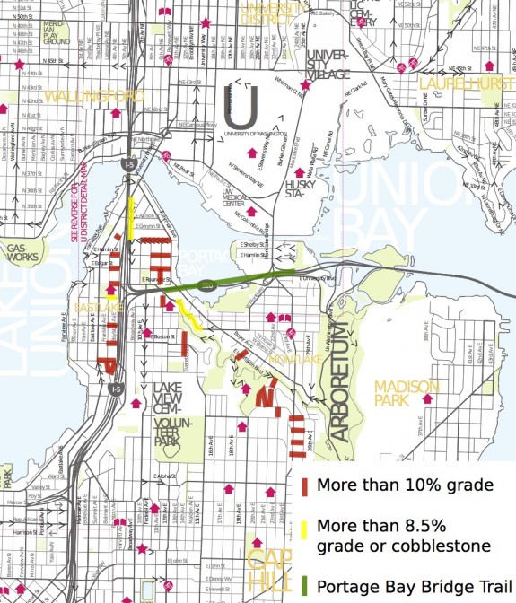
In the group’s continued analysis of the biking and walking elements of the 520 Bridge, Central Seattle Greenways looked at other ways of getting on and off North Capitol Hill. They found what many people have suspected: All roads are very steep. On top of that, the roads with slightly less grades (either natural or through engineering) are busy and uncomfortable for cycling. And many are missing sections of sidewalk or are so close to the freeways that people avoid them when on foot due to the noise and poor air quality.
They use this information to further make the case for the biking and walking trail over the Portage Bay Bridge, but it also has many other implications, especially for people with mobility issues (and, of course, my dream of an I-5 Express Lane Trail). From CSG:
The glaciers did not have walking and biking in mind when they sculpted Seattle, and north Capitol Hill in particular. This geological heritage is part of what gives Seattle its character. North-South elongated hills, hidden valleys, and numerous glacially carved bodies of water. As beautiful as it is, this natural character poses serious challenges to creating an interconnected system of family-friendly walking and biking infrastructure.
— Advertisement —
It would not be hyperbole to think of north Capitol Hill as a topographic fortress. It is surrounded to the east, north, and west by very steep slopes. To the best of our knowledge, there is no ADA accessible route for walking or biking off of north Capitol Hill (check out the map below – compiled from city data and our measurements). Complicating the situation, the streets that were slightly less steep were cherry picked to be arterials for car traffic. As a result, creating an all-ages-and-abilities friendly route between the “urban centers” of Capitol Hill and the University District, and further to neighborhoods in N.E. Seattle and to the Central District, is quite a challenge.
…
A Portage Bay Bridge Trail would bridge this topographic fortress. According to WSDOT, the Portage Bay Bridge Trail (PBBT) would have less than a 5% grade, be well lit, and be considerably more direct in getting to the “Montlake Hub” of regional trails and to Husky Stadium side of the UW campus. It would be the most direct and family-friendly route from the Montlake Hub to Capitol Hill by far.
Even in terms of getting between Capitol Hill and the East UW Campus, taking the PBBT would only be slightly longer than a Harvard Ave E route (1.89 versus 1.63 miles), but would be significantly less steep (4.5% versus 8.7% grade), and much better protected from traffic. Even amongst experienced cyclists, research has found that “cyclists are willing to go considerably out of their way to use a bike boulevard or bike path rather than an arterial bike lane,” and that people will go over three times more out of their way to avoid routes with slopes of over 6% grade compared to those with 4-6% grade (click here find the full article). This affect would likely be more pronounced in people who are willing-but-wary. In other words, since the PBBT will be better separated and less steep than other options, people will choose to use it over routes that currently exist even if they are shorter.
As for people concerned about the width of the bridge, the CSG post has some suggestions for other ways to address the issue. For more, you can also check out this Montlaker post.


Comments
3 responses to “Central Seattle Greenways: Bridging the North Capitol Hill ‘topographic fortress’”
“concerned about the width of the bridge”… what a load of … 5ft for a bike trail on a bridge that is 6 lanes & a break down lane or 8 lanes. that’s like 90 ft already with vehicles driving at 55+.. another 5% width to give people an alternative transportation mode isn’t going to make or break this project.
[…] have written several times before about the 520 Bridge. The biggest issue has been the lack of a biking and walking trail across the Portage Bay segment of the bridge, but there are plenty of issues of nearly equal […]
[…] on, the Central Seattle Greenways blog. Reposted by the Seattle Transit Blog and Seattle Bike Blog. Discussed by the Montlaker […]