The state will fund construction of a new trail through the Arboretum, connecting E Madison Street and the Montlake neighborhood.
Part of the 520 Bridge Replacement Project, the trail will provide a biking and walking route near the historic—but overcrowded—Lake Washington Boulevard. It will also someday connect to the redesigned Montlake lid and trail connections planned as part of the 520 Bridge project, including a trail on the bridge across Lake Washington.
We wrote about the trail idea previously, but now it has secured funding in the early stages of the project, the Montlaker reports. Overall, the state still needs to find about $2 billion to fund the highway replacement.
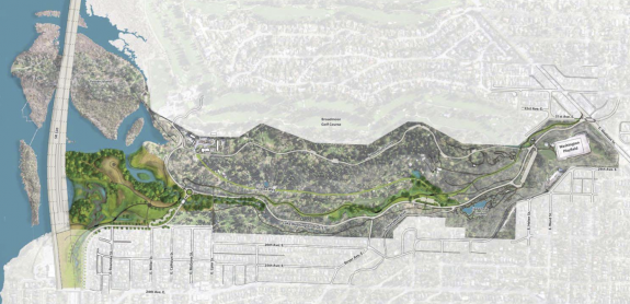
Walking and biking in the Washington Park Arboretum will be easier in the coming years, with today’s announcement of a new multi-use trail to be funded with SR 520 mitigation funding. The trail will connect Madison Street to the south with Foster Island Road to the north in this first project phase. Eventually the trail will extend to the Arboretum’s North Entry expansion and the Montlake Lid when 520 replacement work is finished.
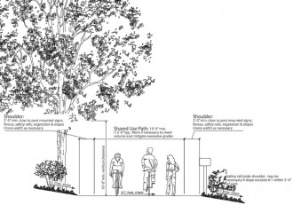
The 12-foot wide trail will meander east of the Lake Washington Blvd thoroughfare, passing the Arboretum’s new Pacific Connections garden, Azalea Way and the Wilcox Bridge. The trail will be paved with semi-rough material to create a bit of noise to alert pedestrians of on-coming cyclists. With this facility, the park will have a new 2-mile loop including the pedestrian-only Arboretum Drive.
This $7.8 million project will be the largest single donation to the Arboretum in its history, said Jack Collins, Arboretum Botanical Garden Committee board member. Funding will come from the $300 million federal TIFIA loan secured last fall.


Comments
20 responses to “State will fund new Arboretum trail”
This will be amazing when completed. Can’t wait!
While they are at it, they should use eminent domain to take 12 feet of the golf course in broadmoor along the water, and give bikes and peds a reasonably flat route to and from the lake.
Totally agree here.
I’m not usually a fan of land takings, but… this is a slam dunk. I’m not sure whether any attempt has been made to work out an arrangement with the golf club, but letting a golf course stand in the way of such an obvious trail connection would be insane. No matter how much a small handful whine about it, no matter what means are used to make it, a direct connection from Mad Park to UW and the Eastside that avoids roads like Madison Street would quickly become an indispensable neighborhood asset. I grew up right next to a bike path and my parents still live right there. They wouldn’t call themselves cyclists, and wouldn’t ride on a street like Madison (or even the road through the Arboretum as it is) but with a trail accessible via side streets they ride significant distances regularly for a variety of reasons. And their trail network isn’t even connected to major commercial centers or transportation hubs like Mad Park’s trail would be connected to UW and all those bus routes up on the lid.
Broadmoor fought like crazy the last time we tried something like this. I’m not sure there’s political will at any level to take them on again via eminent domain, but I agree 100% that the resulting connection would be brilliant.
There are several places in the area where flat, direct access is cut off by bad transportation network design and gated communities. Sadly, Broadmoor already “has their” direct route to the north, so they’re unlikely to care about everyone else. In some other places you might be able to get a coalition of people to support a bike route. A trail bypass of Big Finn Hill, following the water, for example, would benefit a lot of people by making it easy to get out to the Burke, or to Kirkland.
I don’t know the history. What happened in the previous fight?
@Al Dimond wrote, “A trail bypass […] would benefit a lot of people by making it easy to get out to the Burke, or to Kirkland.”
Add a short Trail-only spur from SR 520 to near McGilvra Boulevard E. 37th, 39th, Canterbury, and Edgewater each extend within about 75 to 250 ft. of Union Bay.
– http://maps.google.com/maps?q=E+Edgewater+Place,+Seattle,+WA&hl=en&ll=47.641842,-122.28296&spn=0.007793,0.013797&geocode=+&hnear=E+Edgewater+Pl,+Seattle,+King,+Washington+98112&t=m&z=16
“Meander” & “semi-rough” pavement = frustration for commuters.
Put the bikes on Lake Washington Blvd and let the cars meander!
i’m with bill… there is already a fairly meandery and partially-well-paved trail east of lake washington boulevard, and the only other option west of the boulevard is the always confusing, hilly and also-meandery arboretum neighborhood bypass.
…while the cars once again win with the boulevard itself, the one *at grade* route through the arboretum. throwing ups some signs and slapping paint is not well-designed and forward thinking bike planning. we should be demanding a bike/ped path parallel to lake washington boulevard.
btw, my apologies if i’m not correctly understanding the location of this path … kinda hard to tell with the map.
On closer inspection, this looks more like a pedestrian strolling or bike cruising path, not a cycle track. And routing a cycle route around the tranquil pond below the gazebo? How wacky is that? Routing to isolate the stone cottage at the east end? Is this plan advocating an R.H. Thompson Cycle Route through the Arboretum or what?
@Eric.br: you could enlarge this in your browser
– http://montlaker.files.wordpress.com/2013/01/arboretum_multi-use_trail-1.jpg
Calling it up on maps.google and enabling Terrain can display further.
First choice: The Arboretum is so narrow as it is that any cycle track needs to parallel the arterial corridor, Lake Washington Boulevard E. At least that could make the arterial a divided boulevard.
A better second-choice cycle track than further diminishing the off-arterial Arboretum might be along 25th-26th avenues E.
This is a low speed path. I’m still going to ride the downhill direction (north) of Lk Wash Blvd in the Arboretum. I might use the path for the uphill (south) direction of the Arboretum. Drives me nuts to cyclists going south on the road in the Arboretum.
“The trail will be paved with semi-rough material to create a bit of noise to alert pedestrians of on-coming cyclists.”
Does anyone know what this noise-creating “semi-rough” paving material is? The only trail surface I can think of that makes noise when you ride on it is gravel. But I don’t think of that as “paving.” So maybe this is something new?
I’m never quite sure of this (maybe it’s not decided yet) — is the new lid going to kill the existing Lake Washington Loop route west of the Arboretum? This path seems like it would be a step down for commuters compared to that.
The map appears to depict the trail proposed in 2011. See arboretum seattle multi-use trail. For a closer look at the trail see http://www.seattle.gov/parks/projects/arboretum/files/north_entry_presentation_20110831.pdf.
According to one of the drawings the maximum grade will be 6 to 1 or 16% — pretty steep! Pages 17 and 18 of the second link plot the grade along the trail. The south end has a hill that averages 6-7% with pitches exceeding 12%.
I don’t see how this is better than Arboretum Dr., particularly if the surface is gravel or slow, coarse chipseal. We could spend a lot less money to just connect the south end of Arboretum Dr. to Madison, creating a nearly car-free bicycle road and avoiding hassles with pedestrians on the new trail. The part from Madison to Arboretum might be the only bit of this trail I use.
Darn it, that first link should have been
http://www.seattle.gov/parks/projects/arboretum/
Wow, this is exciting! I’d put myself in the “advanced/skilled cyclist” category, but I’m also a “Captain Safety” sort of cyclist… and I never ride through the arboretum due to the skinny roads, volume of traffic and inability to ‘escape’ (you can’t even run off the road due to the curbs!).
VERY exciting!
[…] 520 project funds new arboretum trail. […]
[…] state is funding a trail through the Arboretum as part of the 520 Bridge project, and you have a chance to get a look at how […]