 The plan is ready. Now is the time to find funding to complete the ‘Bellevue Gap’ in the Mountains to Sound Trail through the eastern portion of Bellevue.
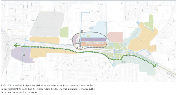
The city recently completed a design study (see below) for a trail connection near or within the I-90 corridor that would complete the 3.6 miles of missing or mostly missing trail stretching from Factoria Boulevard to Bellevue’s eastern border.
This project would have an immense impact not only on regional mobility and bikeability, but also on Bellevue residents and families who have few options for truly safe cycling facilities.
The City of Bellevue, State of Washington, Mountains to Sound Greenway Trust and a long list of supporters (from Microsoft to Cascade Bicycle Club) appeared in a video produced by Bellevue recently to make the case for completing the project (my sincere apologies for the music, which sounds like it is straight out of a Sharper Image infomercial):
Here’s the full design study:


Comments
9 responses to “It’s time to complete the ‘Bellevue Gap’ in the Mountains to Sound Trail (+ VIDEO)”
I can’t wait for this to be done! It is easy to get completely turned around trying to follow the street routes traveling east beyond Factoria Bldv SE.
This is my commute route! I’d love for this to have a trail system instead of a parking lot jog and a sidewalk connection.
Of course Downtown Bellevue is one of the worst places to bicycle commute. No bike lanes, no sharrows, no shoulders and a ton of traffic. So it’s ironic they used the downtown city as a backdrop to the opening.
Are they considering doing the entire route on the south side of I-90? I guess that’s at least consistent.
I’ve been meaning to make a comment about a plan I saw that followed the existing trail between the east end of Eastgate Way and W Lake Sammamish Parkway, but crossed the freeway at the existing ped/bike bridge and followed a new trail along Newport Way all the way to Issaquah before crossing the freeway again at Highway 900. It seemed to make more sense to me to just stay on the north side of I-90 and build new trail along the Issaquah portion of W Lake Sammamish Parkway, which has a pretty wide south shoulder for much of its length, though Issaquah’s Sammamish Trail closer to the heart of the city runs on the north side. Yeah, the existing trail has a few nasty switchbacks east of the bike/ped bridge, but getting from the west side to the bridge or vice versa requires a nasty U-turn because the bridge ramp empties out to the east.
I guess staying on the south side the whole way is one way to get around that problem, but I can’t help but wonder if it might be needlessly expensive and complex for users, not to mention involve a number of crossings. Apparently users will have to head up the trail to 124th and then loop back on a new bridge that hugs I-90 for some distance, and there might not be a direct connection to the 150th ped bridge?
In any case, does Issaquah have any plans to fill or help fill the South Lake Sammamish Gap?
Whoa, my head started spinning after the second or third crossing of I-90, nasty switchback, bridge, etc.
The trail that exists crosses I-90 three times (!) between 405 and Lake Washington. It’s sort of ridiculous. I’m not criticizing your proposal because I actually don’t know the area well enough to comment on it, but I feel like if there’s any standard at all for directness of paths this one fails it pretty hard.
Maybe we need Interstate Highway-style standards for bike trails. Instead of blowing up neighborhoods we can blow up freeways and parking lots.
What do you mean by “this one”? Most of the post was critiquing other people’s plans.
I mean the plan you’re describing in the second paragraph, and as a general comment on how many times the I-90 trail crosses I-90 as it is.
The wider idea is that if we don’t build our transportation infrastructure with cycling in mind first, it ends up being inconvenient and unpopular, and expensive to boot! The fact that we have to go back years after building I-90 and try to add on cycling infrastructure means that the highway was built wrong in the first place.
The trail portion between West Lake Samamish and SE Eastgate way at SE 35th Pl has some nasty switchbacks covered in Moss about a mile East of the trail start. I rode that route with a full load two weeks ago from a Costco run and had to walk all the turns. No visibility around the corners and it’s steep & slippery. It seriously needs an upgrade to be a full fledged commute route. Plus it’s narrow, really only one bike width, but it seems to be lightly used too, so maybe it’s enough of a trail, although I’d like to see it upgraded, might have more users if it did.
As for connecting SE Eastgate Way to the Existing trail at Factoria Blvd, there is a lot of pavement/freeway in the way. Coming up the South side of I90 on SE 36th street has a better grade for the climb but more businesses, and what feels like a lot of traffic, but there is a bike lane there now. It’s busy going East, but going West it’s downhill so you can almost ride in traffic if you want.
[…] MTS Greenway Trust oversees a corridor of green spaces roughly following the I-90 corridor. Though still missing many key segments, the I-90 Trail (also known as the MTS Greenway) is a key component of that […]