 The 23rd Avenue complete streets and repaving project budget has ballooned to $46 million and now includes three phases, stretching from Rainier to Roanoke.
This is arguably the most important commuting corridor in Central Seattle east of I-5. It is also the neighborhood’s most dangerous street and one of the most dangerous streets in the whole city.
Project planners are holding an open house Wednesday to discuss neighborhood greenway routes in the corridor. The meeting goes from 5:30–7:30 p.m. at Nova High School Auditorium in Miller Park.
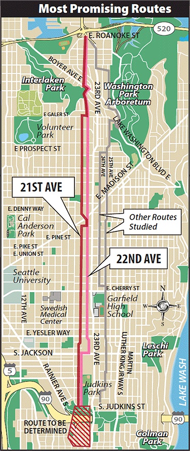
Until recently, the 23rd Ave Corridor Project was only slated to stretch from Madison to Rainier. With the addition of a new phase, extending the project almost to the 520 Bridge, the city now has a golden opportunity to close a vital missing link in the bike route network. Safe bike lanes on 24th Ave would finally connect the Montlake business district and bridge directly to the Central District and Capitol Hill.
While some have argued that a neighborhood greenway parallel to 23rd Ave in the CD would be an adequate or desirable alternative to bike lanes on 23rd Ave itself (I remain unconvinced), there is no continuous, connected and bikeable neighborhood street parallel to 24th. The route shown on the map above does not really exist and would require some intense climbs, especially compared to the relatively gradual uphill on 24th.
I have argued in the past that 23rd Avenue would be a great place for quality bike lanes as a way to truly integrate biking and walking into the Central District’s most important north-south drag. But bike lanes on 24th are undeniably vital, and would be a great way to improve safety on the fast and unfriendly street that currently divides the neighborhood.
Not only would protected bike lanes make the street comfortable for people of all ages and abilities on wheels, they would also help people cross the street on foot.
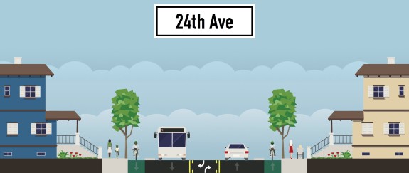
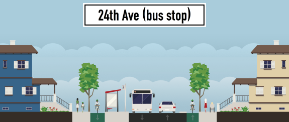
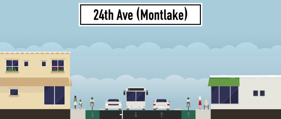
To get those creative juices flowing, I made these quick sketch-ups to show what 24th Ave could possibly look like with a true complete streets redesign:


 I don’t mean to suggest that this is the only possible design that would work. My point is that SDOT’s engineers are certainly capable of designing a street that puts safety at the top of the priority list and keeps the buses moving on schedule.
However, project planner Maribel Cruz said bike lanes are not currently being considered, though they are “not off the table.”
With a budget of $46 million, there is no excuse not to invest in the safety and accessibility of all Seattle and central neighborhood residents. Let’s do this right.


Comments
16 responses to “High-budget 23rd/24th Ave remake is golden opportunity for safe and direct bike lanes”
I find the so-called cycle track they just put in at Broadway to be incredibly confusing. The arrows and green paint are very confusing and it is very hard to figure out where to bike from where to park a car to where to drive. If it’s going to be done, do it well. With that said, I would like to see 22nd done well. 23rd is so very busy with car traffic, I would prefer to ride off of that if possible. Right now though, I feel that is my only choice.
I don’t even like to drive on 23rd!…. Used to be the shootings at Madison and 23rd were a regular feature of the central district.
Also climbing the hill from Roanoke to Prospect with all that traffic…yuk. This is clearly a place I don’t want a two way single lane cycle track, no way to I want to be grinding up that hill at my 5 to 7mph with folks winging down the hill at 20+mph.
While I sympathize with the need for a good connector route for bicycles I’m not crazy about it being 24th.
There’s very little uphill pedestrian traffic on 24th from Boyer to Aloha, and bikes move slowly on the same stretch. Why not integrate sidewalk and bike lane into a single lane on that side of the street, with a nice divider from fast moving traffic?
(I love the detour through Interlaken park & up past the Hebrew Academy to 19th ave, but it’s a hard sell outside of daylight hours, I’d guess, and 24th does have the best grade. The route they sketched in red up 22nd is unusable for most cyclists if you ask me and makes me wonder what non-cyclist generated the proposal.)
Bike lanes on 24th sounds like an excellent issue for the bike community to get behind. I’d recommend the SDOT planners try to hop on a bike and give their 21st ave. greenway plan a test drive- they may be walking those bikes uphill.
SDOT’s approach with 23rd has been to focus primarily on the needs of Transit (the #48), so that’s the big issue to keep in mind with 24th. On the plus side, the auto traffic on 24th is significantly lower than the usage on 23rd.
I ride a single speed up 23rd from Yesler to Madison almost every day – a novice rider can handle this incline.
21st seems like the best route from Judkins Park heading north to Madison as it is an easy incline -after crossing Madison you would than head east to 24th on John – this to me is the best topo route.
22nd has a lot of pinch points; from Terrace to Union – it is really narrow and there is not a lot of room to negotiate.
That plan (21st jogging over to 24th) sounds workable to me. My point about the incline on the 21st/22nd Greenway plan was in reference to the route north of Galer, which is quite steep.
I just moved from living around 23rd and Madison after a year. I’m not sure what the earlier commentator was referring to when he implied that it’s a dangerous area. Heck, the main reason I left the area was because every home around there is easily $500k and they are continuing to build. The other reason I left was 23rd. It’s the worst street in the entire city. Even as a pedestrian, you spend an eternity just waiting for the lights to change and it’s virtually impossible to cross from one side to the other.
I commuted to and from the Udistrict everyday. Interlaken is a beautiful street but it’s not the easiest to get to and once you get to the Central District you are kind of screwed. After the climb from Montlake 23rd is a relatively flat street that would connect the entire neighborhood. I would consider moving back to the area if they fixed that street.
There used to be these dive bars there and untold numbers of fights in the parking lot.
http://seattletimes.com/html/localnews/2020384254_uniontwentythirdxml.html
I commute daily from 20th Ave. and E. Cherry to the UWMC. I like taking 19th to Interlaken. The climb coming up is a bi-ach but its a short block to walk if huffing and puffing is not your thing. I would like to see them connect the ministreet 19th E Ave nub (South of Lynn) behind the Greek Church so that we don’t continue to cut through their parking lot awkwardly.
The 520 underpass is also great (though sightlines need improvement) as this allows bikes and peds to access the bridge and UW without ever needing to cross a busy street after Madison!
I think 23rd is a reach. There are no alternatives for cars and as a former ambulance driver I can say that its pretty indispensable. Going up Interlaken to the West of 23rd or MLK/Arboretum to the East is more pleasant than 23rd. I think we should push to make those routes more bike-centric and we should cede 23rd to transit and cars until more robust bike and ped infrastructure shifts the dynamic.
In sum:
Make 19th and 21st through streets with non-auto priority to make Interlaken more useable (what a cool park!!!)
Make the arboretum/MLK area route clearer and more non-auto centric.
Tidy up 23rd/24th so that its more ped friendly but I think Car+Bus+bike is too much to expect.
I ride 18th, 19th and then 20th from Pine to the I-90 bike trail and in general it’s nice quite back roads of the city. The street crossings are not signaled but the blocks on either side are so that there are plenty of easy crossing gaps. Although I would have trouble with little kids using that technique. Once you are on top of the Capital Hill ridge the grade is easy if not quite level. I’d love it if the city made that route all the way to Interlocken as a bike neighorhood right-of-way.
I agree completely!
I would add that enforcement of the speed limit could IMMEDIATELY improve the ambiance on 23rd/24th.
since having to get off my bikes five years ago, 23rd has been my alternative auto N-S route when I-5 is undesirable. most of the time the 85th percentile speed both north and southbound is 40mph from Roanoke to Rainier. [it slows to 30 in the flashing light 20mph Garfield HS school zone…sometimes. :-) ]
once a week random “emphasis” patrols with at least two motorcycle officers with radar guns giving tickets for more than 5mph over the limit would solve the speeding problem — it did, and has, on several arterials in Bellevue.
I agree with this, and keep in mind also that the Arboretum Foundation has been pushing to limit vehicle traffic through the Arboretum. Their stated goal is a reduction of 18,000 vehicle trips per day to 4,000, and to push all the 520-bound traffic up to 23rd. The city also wants people using the arterials instead of cutting through neighborhood streets. Expecting everyone in the eastern part of the city to suddenly take up commuting by bike, or to use slow transit (with very poor connections in many of these neighborhoods) is unrealistic.
[…] we reported on an expansion to the 23rd Ave complete streets and repaving project, making the case for safe […]
[…] With state Bridging the Gap funding pushing the budget above $46 million, the project is now being planned to change the corridor from Rainier to 520 by transitioning 23rd Ave’s four pinched lanes into a new three-lane layout south of John. Meanwhile, the entirety of the route is planned to be repaved and enhanced to improve traffic flow from the south of the CD to Montlake and 520. Oh, and, yeah, Seattle Bike Blog, god bless its hard-pedaling little soul, wants bike lanes on 23rd Ave, too. […]
[…] due to be designed and built on an accelerated schedule in 2014 so that it is ready to use before a major repaving project begins on 23rd Ave. Only Phase 1 of the greenway and repaving projects (between S Jackson and E John Streets) are […]
[…] due to be designed and built on an accelerated schedule in 2014 so that it is ready to use before a major repaving project begins on 23rd Ave. Only Phase 1 of the greenway and repaving projects (between S Jackson and E John Streets) are […]