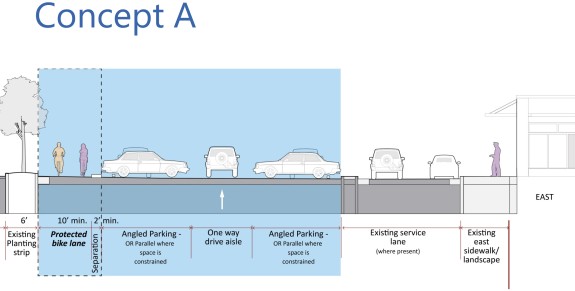
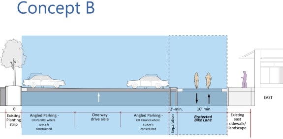
 After conducting exhaustive parking studies and some preliminary feasibility work, planners have come up with two rough concepts for the Westlake bikeway.
The plans are general concepts that planners brought before the Westlake Design Advisory Committee earlier this week to gather feedback and give those involved in the design process information to take back to their communities.
There will also be a public open house to discuss the options the evening of May 21 (location TBD).
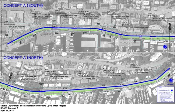
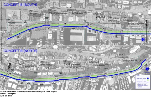
In essence, one option would stick mostly to the Lake Union side of the city-owned parking area and the other option would stick mostly to the Westlake Avenue side of the parking area. A third option on the west side of Westlake Avenue was taken out of the running because early study suggested it would be far outside the project “scope and budget,” planners said.
Both options would increase safety and meet the project’s primary goals, as stated by a presentation to the advisory committee:
- Safety: Provide a facility comfortable for bicyclists of all ages and abilities
- Safety: Provides separation from motor vehicles and pedestrians
- Safety: Provides predictability within parking lot
- Connectivity: Provides connection to existing biking and walking facilities
- Accessibility: Flat, low-stress facility
Beyond the primary goals, there are other project concerns to consider. Here’s how the two options compare on a short list of other concerns:
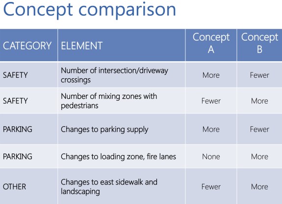 It’s worth noting that even though Concept B has “more” mixing zones with people walking than Concept A, both are much better than the status quo. Today, people on bikes pretty much invent their own ways through the lot since there is no clear good option. This creates a stressful and unpredictable environment for everyone. So while more people on foot will cross the Concept B bikeway vs Concept A (since B is between the parking lot and the businesses/homes), at least people will know to expect people on bikes and the crossings can be designed to modern standards.
As plans develop further, some hybrid of these two options could be possible. Exact routing is not yet determined, though planners do have a concept route of each (click for larger versions):
Parking
By far, the biggest concern voiced about the project is how the creation of a dedicated space for biking will impact the number of parking spaces available in the area.
The quick and simple answer is that Concept B will have a much lighter impact on parking. Many segments will lose zero parking spaces, and many will lose between 5 and 35 percent. The area just north of the small park with the preserved train tracks (and a wonderful bench to chill out and feel a million miles from everywhere) could lose the most parking, at most 50 percent.
But extensive parking studies show that Westlake already has more parking available than is needed. The total comes out to a stunning 1,712 parking spaces along the project area. Of those, 1,271 are publicly-owned and within city right-of-way. The Westlake bikeway project will not affect the private spaces.
Much of the existing parking stalls go unused, and areas with high use can be improved by smarter parking rules so that city-owned parking prioritizes businesses and residents along the corridor.
First, here’s a look at peak parking use. Note that the orange areas represent the city’s preferred usage level (the parking sweet spot), since it indicates heavy use but with enough spaces open that people can usually park near their destinations. Red, yellow and green are not optimal and suggest that a change is needed to get the most value from the city’s space:
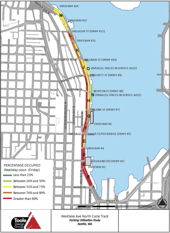
 At first glance, Concept B already seems like a great fit. It would have minimal impact on parking where use is currently the highest, and areas where it would impact parking have enough unused inventory to spare.
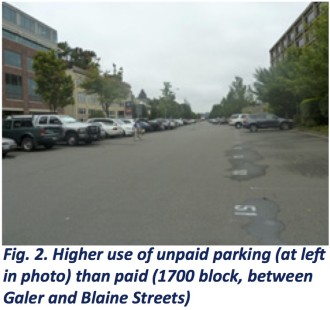
But if you dig deeper, it becomes clear that a lot of the high-use parking areas have inefficient parking rules. For example, 62 percent of parking spaces (that’s 783 spaces) are free to use and have no time limit. These spaces are distributed evenly along the corridor regardless of how heavy use is. It’s probably no surprise that use of these free-to-use spaces is far higher than the metered spaces:
 Having so many free-to-use spaces without time limits leads people to use the lot for all kinds of reasons that do not support area businesses or the city’s parking goals. For example, people can (and do) use the lot as a free park-and-ride (or -walk or -bike) so they can avoid paying for parking in expensive downtown and South Lake Union lots (AKA “hide-and-ride”). This does not help businesses and residents on Westlake, and providing a free park-and-ride so close to the dense downtown core is simply bad policy for the city.
So with a some smart reworking of the parking rules, the city could make the parking much more efficient and focused on providing access to businesses and residences (mostly floating homes and liveaboards).
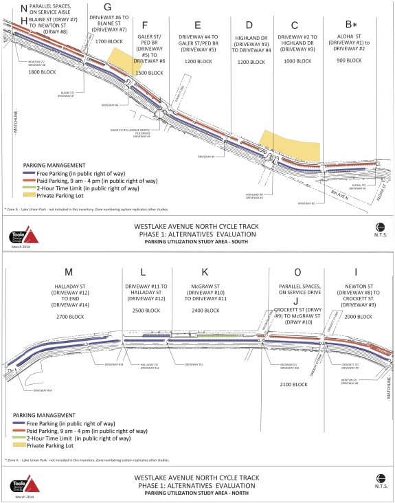
Here’s a look at current parking rules. Once reworked, the new Westlake could be a boon to businesses that currently face parking crunches due to sub-optimal use of the spaces today. Add the new business-focused parking plans to the fact that bike access along Westlake will improve dramatically, and the Westlake bikeway project is shaping up to be a win-win investment.
Of course, not everyone is going to be happy about the plans. There are still people organizing to fight the plans after dropping a lawsuit that delayed the Bike Master Plan. But all this data points out that there is a lot of room for compromises so long as people work together and keep an open mind.
There are still a lot of details left to work out. If Concept B is chosen, there are some complicated driveways, loading zones and boat-launching areas to figure out. And, of course, the parking rule changes would need lots of public input. But that’s what the design process is all about, working through the unique elements of every area to find a solution that best works for everyone.
Below is way more information about parking on Westlake than you ever wanted to know. SDOT really went above and beyond in gathering and analyzing all this. You can find more documents on the project website.



Comments
72 responses to “An early look at two options for a Westlake bikeway + Parking studies show project could be a win-win”
Good stuff, here, either way.
Not sure which option I like best… The one next to the road is straighter & smoother, but has a higher likelihood of Death By Car.
B!
No doubt that B is safer for all ages and abilities. A has too many dangerous conflicts with cars turning into and out of lot.
Would be curious to see a service lane usage survey though. Option B does eat it up, where it exists. That will be a sticking point for some businesses, I suspect. Best to get some data on that, because as we’ve seen, the “stakeholders” invent numbers when they are lacking.
You asked for it: http://www.seattle.gov/transportation/docs/2014-04-04_WCT_TrafficCirculation_Memo.pdf
SO MUCH DATA.
And to provide an actual answer to your question: Businesses that have lots of quick drop-offs and deliveries might benefit from having a few 3-minute and 30-minute spots, especially if they are currently used to using the access lane. That might actually be more convenient, since low parking use along the access lane suggests people find it more trouble to drive through there than it’s worth.
For some perspective, 1,700 surface parking stalls is roughly what you might find at the very largest warehouses and distribution centers in the US, the types of locations that are distinctly – and intentionally – NOT urban, vibrant, or activated.
Yes, it appears that this will be a huge step in the right direction.
To step back from this bikeway project a bit, I just want to point out something about water access and port facilities like we have on Lake Union; that is that the ability to move people and products by water is such a huge asset that is currently way underutilized, perhaps nowhere more than on Westlake. Deep water is an amazing resource for providing a beautiful natural separation of heavy motorized traffic from people on foot and on bicycles, and a fundamental rethinking of the transportation setup in places like Westlake could reduce the risk of transportation accidents for people walking or biking to near zero. This is a big reason cities like Venice and Amsterdam can have such dynamic economies and still be so charming – because they have an entire network of canals for moving things around, without risking running people over. Obviously there are a lot of places in Seattle that are not accessible by boat, but for those that are we can afford to tip the balance of transportation on land much further toward non-motorized uses without sacrificing economic viability. Anyway – I’m not under the illusion that a shift like this is feasible on the timeline of this bikeway project, but I do think it’s something we should keep in mind going forward.
Yes! Let’s dig a canal up Westlake to the core of downtown!
Great info here! I’m agreeing with others that B is safer.
No question B is safer in that the bike way doesn’t have as many vehicle crossings.
I think it is important to carefully review the project goals, in particular “Provide a facility comfortable for bicyclists of all ages and abilities”. In order to do this, it must be comfortable for those who are lolling around the lake and also accommodate those who are rushing along their commute route. In all other cases around the city, fast riders have the option of riding in the regular traffic lanes. In this case, 35mph (with drivers going 40-50), the regular traffic lanes are not safe even for fast riders.
We have the opportunity now to help make this truly work for all riders. I don’t have the answers but the answers probably include either
– bike lanes on Westlake
– a wider bike way (e.g. 15′)
– a slower speed limit on Westlake.
Also, the bikeway needs safe separation from pedestrians. Option B means cyclists will need to watch and avoid peds every 50-100 yards (where ever the crossings are). One way to mitigate this it to put pedestrian friendly barriers at the crossings – something like at the Seattle Center monorail terminal platform. Having some staggered barriers elevates the peds’ awareness by preventing walking straight through.
The project planners said the “design speed” will be ten mph. This makes sense considering the walking traffic and the turns the path will have to make (if Concept B is chosen). That doesn’t mean there will be a speed limit, but they are going to encourage people not to sprint through the area. That seems reasonable to me.
And it seems reasonable to me, too. The point is, the project as a whole needs to accommodate faster riders. Otherwise it will be a frustrating and dangerous experience for everyone. Like I suggested, lowering the speed limit on Westlake is one option.
I hear you on a lower Westlake speed limit. That’s an interesting point I haven’t heard discussed yet.
10mph seems awful slow to me. It’s on the very low end of design speeds for shared use paths, and this would be a bicycle-only facility, right?
And 10mph is hardly a sprint. Judging by the amount of folks who pass me on the regular, I’m probably in the slowest 20% of riders who use the existing parking lot and I can easily cruise at 10-12mph without much effort.
The design speed should be 15 mph. Seriously 10 mph is asking for speeding and accidents.
Exactly. What percentage of bicyclists actually rides at ten mph? I bet the “design speed” of the current parking lot is ten mph. It’s dangerous because people ride faster than that. Designing facilities for the slowest common denominator will create dangerous conditions and waste precious political capital. I’d much prefer sharrows in the parking lot.
i think the details of what exactly goes into a “design speed” of 10 mph will be interesting. For example, there is already ample bike calming in the form of those great raised crosswalks. Maybe that’s part of what plays into the design speed. I think they will not make it so that people cannot go faster. And maybe like car speed limits, 10 will in reality mean more like 13-15…
Ten mph is patronizing—that’s a sidewalk pace, not a bikeway pace. My son would cruise at 8-10 mph on his 16″ bike when he was 3-4 years old—which matches my *running* pace. 15 mph is the logical choice.
I thought the 2014 BMP Update adopting resolution included clear language mandating that “facilities will be designed to meet or exceed applicable federal, state and local guidelines and standards.”
AASHTO says “For most paths in relatively flat areas (grades less than 2%), a design speed of 18 mph (30 km/h) is generally sufficient, except on inclines where higher speeds can occur. The design speed should not be lower than 14 mph (23 km/h), except in rare circumstances where the context and user types support a lower speed.”
The user types for this facility are supposed to include commuter cyclists. Even Dutch commuter cyclists go faster than 10 mph on their sit-up-and-beg one-speeds.
If the design speed of the sidepath is really 10 mph, then SDOT must design the roadway itself to accommodate bicyclists traveling at reasonable speeds.
Yes! If the design fails to include faster cyclists, it will be a spectacular failure telling the public to stop supporting funds for bike ways.
If faster riders can’t use the bike way, they will use the parking lot or Westlake Ave. Peds in the parking lot will have to dodge bikes. Bikes will have to dodge backing-out cars. Westlake drivers will have to slow down to 15-20mph. Somebody will get seriously injured or killed. Everyone else will wonder why we’re building bikeways when so many people don’t use them.
I second Peri Hartman’s comment. If you don’t accommodate for a reasonable speed, faster riders will go through the parking lot. It is a heavy commuter route not just a Sunday stroll. I think 15mph a reasonable design standard.
The speed does seem to be the crux of the problem though. Most cyclists would prefer more “cruising” speeds of 25 – 30 mph (as fitting the commuting nature of their travel) vs the community that is concerned those speeds are too high. Truthfully, riding the area as it is currently at 10 mph isn’t too bad, even with all the vehicles & pedestrians. It’s only when moving at higher speeds (with reduced reaction times) that it become the nightmare it is for some cyclists. Doubt the options available will fix that problem, as faster cyclists will just avoid the cycle track so they don’t have to worry about slow riders.
I had thought that Dexter was supposed to be the route for the “fast” cyclists. If Westlake is going to take on that role, perhaps it makes sense to de-bicycle Dexter and try to shift some Westlake car traffic up there.
Westlake and Dexter are very different streets, separated by a giant cliff. Just like you wouldn’t tell someone on Westlake to park their car on Dexter, it does make sense to say the same for someone on a bike. They look close on a map, but they might as well be separated by a lake.
Since Dexter and Westlake essentially meet each other at the north and south ends, they can substitute for each other for those traveling the full length and not exiting at an intermediate destination. I would certainly tell someone planning to drive along Westlake to consider using Dexter instead and vice versa. The “cliff” aspect does make it harder for bikes to use Dexter, which is why I suggested that if Westlake is to be an all-speeds, all-purpose bike route, then separating modes of transit by eliminating the bike facilities on Dexter and shifting at least some car traffic up to Dexter from Westlake would improve speed and safety along both routes, for both bikes and cars.
I’m starting to get the impression that the intended use of the Westlake cycle track has not been thought out yet — that the political decision to build it was made before figuring out what it would be used for. I’d hate to end up with a 520-style boondoggle where design was shortchanged for political expediency.
@Mondoman – right, I’m not sure they’re taking into account who will use it. It really doesn’t matter what SDOT intends; what matters is what the riders choose. If riders choose Westlake and want to go 15-20mph, they will, regardless of the facility. That may mean riding through the parking lot or in the Westlake traffic lanes.
SDOT – wake up!
If this route gets half the bike traffic proponents have suggested, is 10 feet really wide enough for a 2-way sidepath? NACTO calls for 12 feet for a cycletrack.
Unless the city successfully encourages faster cyclists to stay in the street on Westlake, this route will have quite a mix of speeds, and there are already complaints about overtaking cyclists with the parking lot the way it is today.
Both designs appear to call for 2 feet of separation between the back of angle-in parking and the path. Unless that’s enforced with some sort of continuous physical barrier, many pickup trucks hang quite a way back from their rear tires when backing into a space, and trailer hitches often protrude even further. I’d expect considerable vehicle overhang when someone parks a full-sized pickup set up for towing boat trailers.
It’s 10′ minimum, not the whole way. And that does not include the separation space, which is another 2′ minimum. Especially if the service lane area is picked, those spots would be much more than 10 feet wide. But there are pinch spots, and 10′ is considered acceptable for a two-way bikeway so long as it also does not have people on foot. For a multi-use trail, 12′ is the minimum standard these days (though there are sections of the Burke-Gilman that are skinnier even than 10′).
So, long story short, a 10′ minimum is fine and probably gives a little more room for compromise.
Well, of course the buffer isn’t included in the trail width.
Buffer space is mandatory in addition to paved path width.
This design suggests to me that SDOT is ignoring the City Council’s clear mandate that bicycle facilities comply with Federal, state, and local standards.
The huge problem with A is that pedestrians are going to regard the path as an extension of the sidewalk. This happens all the time on Alki, to the point that I don’t use the path anymore.
Option B does not have to be more dangerous. The number of driveways could be reduced and the remaining ones signalized. Signals would make entering and exiting the parking lot safer for drivers as well as cyclists.
Dangers from cars are more or less predictable and can be designed for. Pedestrians crossing or meandering along the bike path are not predictable or controllable.
Back-in parking is good in both options. It removes the hazard of being doored by a passenger — again, see Alki.
Oops. I swapped A and B. There will be too many peds on B. Concept A can be made safe with traffic signals.
Concept A can be made safe with traffic signals, but will it be? Currently just three of the fourteen driveways across such a path have traffic signals. Are 11 new traffic signals really going to be within the scope and budget of this project when a west-side path isn’t? Would the city stand any chance of reducing the number of driveway crossings when it couldn’t even do so on Linden, where the opposition wasn’t nearly as organized?
Even signals might not be that good of a solution when a center turn lane can’t be added along most of the roadway (SDOT is committed to a four-lane Westlake at least through the cycletrack’s completion), so there’s no way to stop uncontrolled left turns without stopping a direction of through traffic at a time. Since most of Westlake’s traffic is through traffic that is just not going to happen.
I vote for both A and B. Make A a fast track design for commuters and fast cyclists on the west side of the parking lit, and B a 10 MPH design suitble for all abilities on the east side. Limit the number of entrances from Westlake to the parking lot crossing the A design, and have them all signaled. 1700 parking spots is way too much for this area, clearly many parking spaces can be lost to improve this very important transportation corridor.
I prefer B initially. One of the concerns voiced to me by my friend who works on Westlake was the danger (and challenge for drivers) dealing with the “cycle track” idea right along the road. The speed of traffic on Westlake usually requires a very quick decision turning left in or out. I’d much rather fend with ambling pedestrians (a la Burke through the UW) than a car suddenly turning left into me. Also I think the plan with the most parking will be easier to sell to the other parties involved.
Has there been a specific dollar amount attached to the cost of running the cycletrack on the west side of Westlake? It may very well be outside the budget of the project, but it would be nice to know by how much before we eliminate what seems to almost certainly be the most desirable option. I do find it strange to call that option “outside the scope” of the project.
That’s a very good question. I heard via CBC that any part of Westlake is considerably more expensive because the street is engineered for heavy vehicles (semi tractor trailers) and SDOT doesn’t want to repurpose that facility.
But I think there are unknowns. First of all, if the speed limit is lowered, can the lanes be shrunk by a foot or so leaving more room for bikes without reducing the number of lanes?
Or, how much room is there on the west side of the sidewalk? Can the sidewalk be widened to accommodate cyclists (there are very few peds there).
The consultant at the public meeting in the fall mentioned between $400k – $700k, due to slope stabilization needs on the west side of the street. I got the impression he was told in no uncertain terms to work within the current funding, as no additional money would be available.
Nice write up Tom! I’ll add two things to consider:
1. As for the minimum bike lane width of 10′, I think it’s highly likely to be far larger than that in Option B. Most of Option B uses the full width of the service lanes, which are probably more like 15-18′ in width. However, in a few places there will be 10′ pinch-points.
I’d expect that Option A would be much closer to 10′ wide throughout the entire corridor. Option A already removes a ton of parking (40-45%). Widening Option A would remove even more spaces from the parking lot, so there’d be a lot of stakeholder pressure to keep it narrow.
So, B would likely be wider than A.
2. For the sake of the businesses on the westside of Westlake Ave N, I’d like traffic lights & crosswalks installed in a few places along the street. Reducing the speed limit is a good idea too, even if it’s just to 30 mph (it’s currently signed for 35 mph and the average speed is 40 mph).
I like the idea of option A with reduced speed on Westlake and a raised grade cycle track where motorized vehicles would cross.
After going on the policy ride with my wife and kids I don’t like the looks of the wiggles on B or the pedestrians that will be crossing to businesses.
I think there needs to be a good option for people riding faster than 10 MPH or riders will just spill back out into the driving aisles.
Forgot to add, I like all that was written about utilizing the parking for the correct purposes. Never heard the term hide-and-ride but I like it and it describes how many people use these lots.
I am really concerned about the design speed of 10 mph. It feels like this is being designed for tourists who don’t bike rather than the vast majority of potential but wary riders who comfortably ride 10-15 mph. I like the idea of providing a way for tourists and their out-of-town wallets to enjoy Lake Union, but we are missing a lot of potential commuters. We are building a path way below its potential by building it for 10 mph, and most that use the trail will not go at such a slow pace. The design speeds needs to be at least 15 mph.
I am also dismayed by all the attention on the parking. I know this is because the people who sued care about the parking, but it is amazing what an incredible city resource is being nearly given away. I estimated the city right of way to be 1.5 miles long by 90 feet wide. Assuming a low-ball estimate of $250 per square foot for land around there, the city land we are talking about is worth close to $300 million. My guess is that the true number is even higher. Anyone have more solid numbers? So, what we are saying is that the city residents of Seattle can’t turn even half of the space into a park so that they can enjoy being near the lake front? It is our land. Why are we still talking about practically giving it away for parking?
I was floored to read Tom’s description of the parking survey. If all you did was listen to the “stakeholders”, you’d think the parking was 100% full 24x7x52. If the city were to start charging even a fraction of the pavement’s true value I think we’ll see that all the car parkers don’t really need so many parking spots so badly after all.
It’s important to note the “survey” was done over 2 weeks at the end of Sept – early Oct. This is outside of the average usage periods and a few of the business along Westlake that host events on the weekends (China Harbor) were not booked those weekends. This painted an unrealistically low evening/weekend usage picture. The consultant specifically said he did not make any seasonal adjustments, nor did he intend to. I’d say the survey reflects accurately the “off season” usage, but no where near the average (not to mention busy) usage periods.
I appreciate everyone’s concern about the 10mph design standard. I think we’re all losing sight of what that means. SDOT’s goal is to design either Option A or Option B to feel safe for someone who rides 10mph. That doesn’t mean that someone who goes 15mph or 18mph won’t feel safe too, or that it’ll be too slow.
Actually, I’m a little worried about Option A being slower. It’s possible that the design would legally require bicyclists to stop before each entrance/egress into/out-of the parking lot. This would discourage many faster bicyclists from using it altogether.
Is that what “design speed” means here? For cars, the term means designing a road so most people go that speed. Of course it doesn’t mean you can’t go faster: People drive 40 mph down my skinny Seattle residential street every once in a while, but I bet the average speed is closer to 20 (the city-wide average for streets like mine).
I do think it’s not something to get too hung up on. There are already elements like the raised crosswalks that will have a calming factor on speeds. But I guess I am curious what “design speed” on a bikeway entails. I assume we’re not committing to things like those dangerous bike speed bumps that Portland is now uninstalling: http://bikeportland.org/2014/04/21/county-says-hawthorne-bridge-speed-bumps-will-be-removed-in-2015-104889
The best bike calming method I know of is more bikes, and to that end I’d say we’re on the right track :-)
(As you already know) I completely disagree. Those going 10mph or slower can ride safely on a wide sidewalk. There’s no danger mixing with peds or joggers who are going the same speed or somewhat slower.
In fact, cyclists going 10mph probably don’t want to mix with those going 20mph. If we want to build a facility for those nominally going 10mph, we only need to widen the sidewalk a bit.
However, while we want to somehow accommodate slow riders, we’re designing a system for all. That means design speed that is safe at 15-18 mph. Tight curves, narrow lanes, too many wide-open ped crossing do not make a safe 15-18 mph design. Yes, people will go 18mph but it won’t be safe.
I do think it is an important issue.
I don’t think anyone is arguing that the facility shouldn’t feel safe for folks traveling at different speeds. The issue is that “design speed” is a technical term that, while it certainly impacts the user experience, actually has more important implications for how the path is designed and engineered.
A 10mph design speed – if chosen – will influence very important path features, including sight distance, curve radii, vertical curvature, etc. This is important! Well-intentioned low design speed facilities can actually be MORE dangerous than higher design speed facilities if the facility’s user group by and large desires to travel at faster speed.
Sounds like this is one of those “community concerns” that cold be brought up at the next Design Advisory Committee meeting.
SDOT’s goal is to design either Option A or Option B to feel safe for someone who rides 10mph. That doesn’t mean that someone who goes 15mph or 18mph won’t feel safe too, or that it’ll be too slow.
That’s not what engineers normally mean by “design speed,” are you sure that’s what they mean here?
AASHTO says, in part:
DESIGN SPEED
The speed a path user travels is dependent on several factors, including the physical condition of the user; the type and condition of the user’s equipment; the purpose of the trip; the condition, location and grade of the path; the prevailing wind speed and direction; and the number and types of other users on the path. In most situations shared use paths should be designed for a speed that is at least as high as the preferred speed of the fastest common user.
Design speed influences things such as stopping sight distances and turning radius for corners.
AASHTO doesn’t even publish numbers for a 10 mph design speed, it’s off the bottom end, but at 12 mph, they allow a turning radius as tight as 27 feet. Going just 16 mph bumps that up to 47 feet. Stopping sight distance at 12 mph is under 80 feet, at 16 mph it’s about 120 feet, both assuming zero slope.
So yes, if design speed really is limited to 10 mph, going 16 mph won’t just feel unsafe, it will be unsafe.
I realize this isn’t officially a shared-use path, it will be posted as a bicycles-only sidepath, but realistically, will there be sufficient education and enforcement to ensure it isn’t used by pedestrians, wheelchairs, rollerbladers, etc?
AASHTO further notes “typical” adult riding speeds of 8-15 mph on level ground, while “physically fit” riders should be expected to reach 30 mph.
If the goal is really an all-ages facility, you need to design for at least the 15 mph speed of ordinary, non-physically-fit adult riders.
(I don’t think there’s any real prospect of an all-ages and abilities facility here, there really isn’t room for a 30 mph design speed for fit recreational riders, and even AASHTO acknowledges that racers, who go over 30 mph on level terrain, are likely to stay on the street anyway. But it should at least be designed to accommodate adult couch potatoes on cruiser bikes at 15 mph.)
The concerns expressed for the Tour de Commute rider having to slow his pace a bit and to watch out for pedestrians fall flat for me. It’s a common facility, not a time trial route. There are going to be compromises.
In fact, the complaints sound awfully similar to our motorist friends complaining about that bicycle taking up his “car” lane and about those pedestrians that keep wanting to cross the street in front of him. “But I could go so much faster if no one was in my way!!!”
Boo hoo.
May I point out that there’s a big difference between being held up by a slow rider until it’s safe to pass. Versus not being able to go much over 10mph because it’s dangerous in general – the curves are too sharp, sight lines too short, ped crossings too open, etc.
I encounter slow riders in the various bike lanes. No big deal. I pass when it’s safe and go on.
As a “strong” commute rider, I used to think I could hit 40mph downhill in a full tuck. And then I got a GPS run and realized that it was much closer to 27mph.
But my GPS runs also showed that I can keep a very easy 15mph to 17mph without a lot of work. And that 10mph feels like I’m crawling.
Hence my concern about a design speed of 10mph. That the sight lines will be terrible and that I’d have much more likelyhood of a collision with either a pedestrian or a car, leading me to want to ride on the road but that it will be too narrow/fast leading me to hate bicycle paths.
A 10 mph design speed vs. 18 mph isn’t an issue about “tour de commute” riders, but for adult riders in general — it’s slower than the standard design speed for couch potatoes on beach cruisers.
Let’s not get into how joggers tend to use bike lanes and dedicated cycletracks.
Option A is a fail. I bike every day on Westlake to work and my primary concern is getting pasted on to the hood of the cars turning off Westlake into the parking lot at a 45 degree angle at high speed. Happens every day and any visual obstruction-like the current mix of dumpsters and tall SUVs-is a death trap. With option A, I’ll still be biking down the middle of the road twice a day, like it or not.
+1
The only thing that could make it do-able is if the number of driveways were reduced and all were signalized. That would have to be accompanied with ways to keep people from cruising the length of the parking lot, like cutting off the through-route.
Plus, I think this facility should be park-like, since it has so much potential along the waterfront! Between a road and a parking lot is not really living up to the potential of this area. Can joy be one of the project goals?
There really is no waterfront here. The entire shore is lined with businesses. However, surrounding the trail with lots of grassy spaces would be nice.
I think it would need to be implemented with the trail at a higher level than the street or parking lot. Entrance/exits to the parking lot would need to be designed to require true 90 degree turns.
I cast my straw vote for Concept B. It’s a bit more meander-ish, but that’s not a clear negative. It’s going to be a far more pleasant facility for the majority of users than a skinnier track adjacent to Westlake, with its driveway crossings. The crossings alone make this choice seem like a no-brainer. The added benefit to the businesses is that it directs cyclist traffic to their front doors, as opposed to treating the Westlake corridor as a mere throughway.
Yes, ‘B’ is better, because pedestrian/bike accidents are better than pedestrian/car accidents (especially when the car is going 30 MPH). Too bad we couldn’t get the west side of Westlake circle track, because I think that would have avoided both. There is a very long stretch of road on Westlake that doesn’t have any intersections. Then, when it does have intersections, there are traffic lights. But there would have been some work needed as it approached the end of the lake (e. g. does it go down 8th or 9th, or cut over on Higland Drive?). This solves that problem (it essentially hugs the water). ‘B’ sounds good enough. The popularity of it will help reduce bike/pedestrian accidents (as well as some well placed signs outside the various shops).
Where is the funding for this coming from? And are bike riders willing to chip in to help off set the cost from car taxes.
Oh please. Not another tax-the-bikes troll. Roads are mostly funded through property taxes, which everyone who isn’t homeless pays.
Actually, I’m interested in the first question. It’s true that gas taxes are a state tax and that goes primarily to state roads (which Westlake is not). But there are other taxes like the $20 license tab tax which I think, in part, does go to city streets (but mostly to transit).
So, where do the funds come from for Seattle streets? It’s off topic for this discussion. Tom, would you be interested in publishing something about this elsewhere?
Also, the cheapest way to increase road capacity is to keep more cars off the roads. Like by encouraging people to bike.
According to SDOT,
“The budget for the Westlake Avenue North Cycle Track Project is currently estimated at $3.6 million. Funding comes in part from the Federal Highway Administration through the Puget Sound Regional Council (PSRC). The PSRC awards Congestion Mitigation and Air Quality (CMAQ) funds in a competitive process for non-motorized projects across the region. The project is also funded by surplus funds from the Spokane Viaduct Project as well as the bonds for the Cheshiahud Loop.”
So it would appear Westlake uses even less motorist user fees than the average Seattle street.
I don’t have Seattle numbers handy, but according to the Tax Foundation, hardly a bunch of liberal activists, gas taxes, tabs, and other user fees on cars cover about 1/3 of the cost of roads and streets in Washington State, and most of that is at the state level. City streets are mostly general-fund expenses.
For streets in general, SDOT says:
Funding for Street Improvements
The City of Seattle pays for work on streets, bridges, and other parts of the transportation system with funds from a variety of sources, including federal and state grants, gas tax revenues, local fees, and the City’s General Fund. Federal and state grants must be matched with local funds.
In 2006, Seattle voters passed a nine-year, $365 million levy for transportation maintenance and improvements known as Bridging the Gap (BTG) which is complimented by the commercial parking tax. Since 2007, more than $20 million a year has been invested in street improvements along Seattle’s arterial streets helping to make up for the diminishing amounts available from other sources during the economic downturn. BTG will expire at the end of 2015.
In 2010, the City Council formed the Seattle Transportation Benefit District (STBD). The STBD is a separate entity from the city and in the fall of 2010 they voted to put into place a $20 Vehicle License Fee. This fee raises approximately $6.8 million a year and $2.7 million is currently dedicated to pavement preservation.
http://www.seattle.gov/transportation/streetmaintenance.htm#fsi
Since option B doesn’t have any forced right-angle turns, I have no complaints about it. Heck, I’d be fine with SDOT making that turn optional when coming from the parking lot heading north.
[…] As we reported in April, planners are gathering feedback to inform and develop the plan for the bikeway, which will be built in the super-sized publicly-owned parking area to the east of the roadway. Planners presented two basic ideas in April, both of which would be vast improvements over the dangerous and confusing status quo: […]
[…] were present to answer questions related to the display boards. There were also several tables with detailed segments of the Westlake ave parking corridor with paper provided for comment for each […]
[…] points of conflict and displacing the fewest parking spaces. The city has improved the idea since first presenting “Concept B” earlier this year by removing some of the twists and turns that some feared would make it less […]
[…] biggest concerns people raised during the public outreach phase were about parking. Initial plans showed that most segments would displace between 5 and 35 percent of parking spaces, but a couple could […]
[…] sometimes tense and drawn-out community design process went over the entire project inch-by-inch and parking-space-by-parking-space. After a series of major design compromises — some of which […]