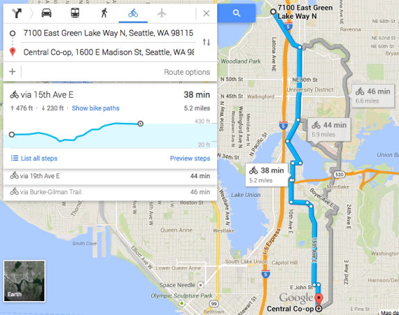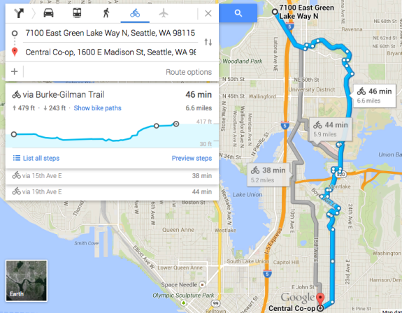
 Google Maps does not always give the greatest bike route suggestions, but it is a powerful tool for planning a ride to an unfamiliar place. The Street View and satellite image features are incredible ways to answer the questions: How busy is that street? Does it have a shoulder? Can someone biking get through that dead end?
Now it can help answer another question that is a big deal for people biking in Seattle: Which route has fewer hills?
The company quietly launched a new feature to the desktop version of its maps website that gives an elevation profile for bike routes. It’s a handy way to get more detailed topographical details than the existing “terrain” layer.
Hills are an often-cited barrier to cycling in Seattle, but they are also a source of immense rewards. The city is full of breath-taking vistas and wooded hilly back roads that add to the draw of using a bike to get around. And you have to go uphill to go downhill.
But even Seattle’s most formidable hills usually have routes that are less steep and, perhaps, less obvious. So the new Google feature is one more tool to help you find them.


Comments
22 responses to “Google Maps now gives elevation information for bike routes”
Cool! This will help a lot. Now, if the city would put as much thought into E-W routes as they do into N-S ones…. Getting from Ballard to Wallingford without (a) grinding up Market in heavy traffic, (b) looping all the way south to Leary, miles of the way, or (c) getting lost in the tangle of dead-ends on the hill would be nice.
That is so true! I ran into that a few times. I remember leaving Reuben’s Brews and trying to get to Bottleworks, and running into what you describe.
As someone who lives on the side of the hill, I sympathize. There’s actually a marked extension of the 58th greenway that jogs south on 6th and up the hill on 56th, then turn on Greenwood and up a block to Phinney and follow the bike path down 50th. It may be shorter than going around to the south but it’s up and down the hill…
You got to ride your bike from point A to B. I don’t see what the problem is.
I just noticed this feature this morning and was very excited!
Hmmm, I just tried plotting out a route and it wasn’t there for me…
Got it, have to use the “new maps mode” which sucks because everytime I tried to drag the path to the actual roads to use, it zoomed out and didn’t move the path.
What crumby QA testing to have released this buggy piece of sh*t.
It worked great for me on my desktop computer (using a mouse to click and drag). I have run into the problem you are talking about on my laptop but I think it is a trackpad problem, not anything to do with this new elevation feature.
It’s not (or at least shouldn’t be) a trackpad problem if you use the trackpad as a different kind of mouse, that is, not using the actual pad to click the mouse but using the button that simulates the same purpose; this works especially well for click-and-dragging. I think the computer receives the same input from the trackpad as it would from a mouse if you use it like this, so there should be no difference. (Now if you use a Surface, that could be another matter…) My main problem with nu-Maps is that it is such a memory hog.
This does sound cool. Google Maps and Street View has been indispensable to me.
And, of course, if you find information that isn’t represented on the map regarding bike access you can add it via MapMaker. Greater Seattle tends to have pretty good data on bike infrastructure, and lots of that comes from user edits (especially little things like cul-de-sac punch-throughs and contraflow bike lanes). Just remember, if you’re going to add park trails, that it’s not legal to bike on many narrow, soft-surface park trails in incorporated Seattle… so even if you use them yourself, you shouldn’t mark them as having bike access in the map data.
I wonder when Google maps will get the average time anywhere near close to actual time to ride. Looking at the raw number would put many people off from even trying a longer ride. I’m not that fast but I can usually do the suggested routes in 2/3rd’s of the time they post.
Ditto! I just moved a few weeks ago to a new part of town, biked in for the first time today, and when I got in looked at the Google Maps it estimated my 19 minute trip as 37!
not for me. It is pretty much right on. I think I am medium speed (I pass about as many people as pass me on the Burke Gilman).
Perhaps it can be more accurate for trail rides vs. for streets (I don’t know if it tries to factor in stopping for traffic lights, etc.).
Me too. Google’s estimation of biking speed is pretty close to mine, and I figure I ride at a pretty average speed.
Yeah, I’m slow and usually add about 5 mins to google map times. I love the elevation feature, but I disagree when it says “mostly flat” sometimes. If I have to go up Marion between 1st and 2nd, it is NOT flat, I don’t care if it’s only a block I still want to avoid it.
It calls Marion between 1st and 2nd flat? Wow.
There ought to be elevation shown for walking, including any walking as a part of taking a bus or car.
Frustrating that it’s only available on the desktop version. I’ve noticed that the web version of google maps is falling more and more behind, with the new interface lacking many features of the classic interface (and having a terribly designed UI in general).
what do you mean? (i.e. what is the “web version”- do you mean the mobile phone version?)
While I’ve been enjoying this feature, I’m going to point out that it isn’t foolproof. Just plotted a ride from Pacific up to Ravenna, which Google currently describes as “mostly flat” While it isn’t a brutal grade, it is most certainly a hill….
[…] Elevate your maps: Google Maps adds a hand feature for cyclists, now you can visualize your next bike ride with route elevations! […]