If you were wondering whether the city’s investments in neighborhood greenways are effective, here’s your answer: A resounding yes.
The city wisely gathered bike use data on a couple proposed neighborhood greenway routes before work began. They then compared those numbers with bike counts after the street got the neighborhood greenway treatment, and the result is astounding.
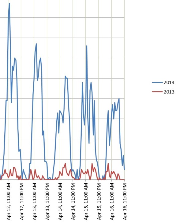
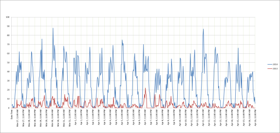
On Ballard’s NW 58th Street, for example, average daily April bike counts increased 805 percent in just one year (from 64 in 2013 to 579 in 2014):

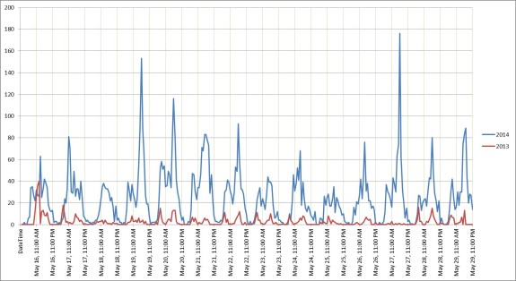
In West Seattle’s Delridge neighborhood, average daily May bike counts increased 635 percent on 26th Ave SW:

Obviously, these are not all new bike trips (though some certainly are), but it is evidence that neighborhood greenways are effective at providing an attractive bike route. People who biked on other streets before the greenway was installed have changed their habits to use the new calmer street with improved crossings at busy streets.
And these greenways are not even perfected yet. While the NW 58th Street crossings at busy streets like 24th Ave NW are improvements, they are not as good as they could be. And, of course, the greenways are among the first in the city, so they are not yet connected to a planned network of neighborhood greenways, trails and protected bike lanes. When that happens, transportation in Seattle neighborhoods will never be the same again.


Comments
30 responses to “Do neighborhood greenways increase cycling? Oh yes.”
I use the 26th Av SW Greenway for many of my daily bicycle commutes. It has the delightful advantage that it parallels and then ends on the Longfellow Creek Heritage Trail which I then bicycle. Chirping birds and bubbling brooks give the illusion of being deep in the country. It doesn’t surprise me that it is popular with cyclists. Far better than the frenetic pace of Delridge.
Thanks, David. I’m curious, did you use 26th before it became a neighborhood greenway? If not, what made you switch?
Tom,
I had been commuting to Arbor Heights from the Swing Bridge via Delridge prior to the 26th Greenway opening. The new greenway signs on Andover and Delridge triggered my curiosity and once I tried it I really liked it. Now I use it regularly.
It’s cool how a couple relatively small changes can make such a big difference.
The NW58th St greenway has certainly changed my own route preferences; before it was rolled out, I would semi-arbitrarily choose a street in the high 50s-low 60s for an east-west trip through lower Ballard, but now I nearly always take NW 58th. I can’t say that I’ve increased my number of trips, but I have certainly concentrated my trips onto that route. It would be nice if we had before-and-after numbers on nearby E-W streets, to be able to get a sense of how many of these are “new” trips vs. just re-routed trips.
I’d also be interested in seeing the data on car traffic on greenways after the rollout. A lot of the (minimal) opposition to greenways, at least in Ballard, was a fear that car traffic would re-route onto the greenway to take advantage of the controlled crossings, or that speeds would increase, etc. Has that come to pass?
I’d like to see that, too, Matthew, because I’ve been doing the same thing — whenever I head to a brewery in Frelard, now, I take 58th, but I’m not making any more trips to breweries than I used to.
On the other hand, I think there’s value in that consolidation. Drivers on 58th really do seem to be more aware of bikes; I perceive 58th as safer for a bike than the surrounding streets.
I’ve done the same as Matthew – now that there’s safe(r) crossing at the major arterials (8th, 15th, 24th) in Ballard on 58th than the surrounding streets, I basically always take 58th unless I need to deviate for some specific reason. I haven’t had any problems with cars on 58th, although I didn’t really have problems with cars before, except on the arterials.
I’m curious how the counts were obtained. Did someone watch weeks of video, because tubes don’t count bikes very well.
Tubes, tuned to get bikes but not cars. As for the accuracy rate, that would be interesting to see. The city seems to think they are accurate.
I have experience deploying automatic bike counters that utilize tubes, and they work just fine as long as the sensitivity settings are calibrated correctly.
I’d planned to double-check the counter on 39th Ave, but then I moved away. It should be pretty easy to do, assuming you have an hour or two to spare. I’d suggest doing it towards the end of the month, so that you don’t have to wait an entire month to check the numbers. SDOT releases numbers once a month at the end of each month.
The Ballard greenway has become my preferred way to get from the Burke-Gilman to Ballard or beyond–I get off the BG at 8th, go up to the greenway, and enjoy a nice ride through the neighborhood rather than mess around with the missing link disaster. It’s less direct, but way more enjoyable.
The 58th greenway in Ballard has become my preferred east/west route during peak traffic times – in a car! I find that all of the flipped stop signs makes it a convenient alternative to Market. I’m polite to cyclists when driving 58th, but I’ve found that many other drivers are not. The few times I’ve biked that route with my young son aboard (meaning very slow: 5-10mph) we’ve been crowded and followed closely for many blocks. It’s not pleasant.
Bottom line: without frequent diverters for auto traffic, these greenways are just as convenient for cars as bikes, which inevitably leads to uncomfortable bike/car interactions. I’m surprised they’re seeing the huge spike in use that they are.
They don’t have traffic diverters? That won’t work. Toronto and Vancouver both have greenways but the ones in Toronto are useless as anyone can drive into them leaving people cycling to have threatening cars behind them. The ones in Vancouver have traffic diverters and alternating one-way blocks for cars/two-way for bikes. Works much better.
The 58th greenway has a single diverter at 15th, but it only blocks eastbound traffic. Other than that, it’s a free ride for cars. That’s why I, and many others, drive on it regularly. Sure beats the traffic lights on Market!
But I’d happily trade this handy car shortcut for a safe bike route.
Agreed. Diverters make streets like these soooo much more comfortable. I get that there’s some resistance to them, at least at first. But it’s worth it.
I’ve actually seen someone drive a car through the 15th Ave diverter. The driver was turning right off of 15th. I recall the car being rather small (maybe a Smart or a Mini?) and just barely making it through, with the tires scraping against the curb.
Greenways are supposed to supplant parallel arterials, right? They should have also done a “before” count on both the arterials and the greenway street to compare rerouted versus new trips.
I live on 58th.
I lived on 65th (one parallel arterial) when I started bicycling again, about 10 years ago.
I also walk along Market Street quite a bit.
Before the greenway went in, my observations were that 58th already had more bicycle traffic than Market or 65th. 65th has sections that are high speed enough to discourage some cyclists. On Market, you’d be more likely to see someone trying to bicycle on the sidewalk through crowds of pedestrians than riding on the road due to the poor pavement in places, heavy congestion and peak speeds in the stop and go between stoplights. Neither Market nor 65th are places where you would want to bicycle with children.
Since the greenway has gone in, I see a much higher percentage of families with young children bicycling along 58th. I see many more longtails, trail-a-bikes, and cargo-bikes now than I ever did before.
I call that a huge success! We have a low-stress bicycle route that feels safe enough that families regularly use it.
[…] As we reported yesterday, Seattle’s neighborhood greenways are attracting a whole lot of people on bikes. One route in Ballard even led to an 805 percent increase in people biking on the street in just the first year of operation. […]
I wish the information on “counts” were far more detailed. And those of us who are not local, and who don’t know what the streets look like, have no idea what you mean by “greenway.” So, yes, this sounds promising, but wishful thinking may be hiding behind vague reporting.
What more info on counts do you want? A person bikes past a counter, it adds 1.
Your reply isn’t very helpful, Tom, and comes across as sarcastic. I agree that more info, like counts on parallel streets and cars counts would be helpful. John, “greenway” is the Seattle term for what Portland calls bike boulevards – local streets designed to better serve bikes and peds while still accommodating local car traffic.
You’re right. Grumpy morning. Apologies.
People planning car-oriented infrastructure take for granted a level of detail that Seattle is just starting to hint at for bicycle facilities.
How about before-and-after plots, not just of the affected routes, but of parallel routes, and of the intersecting streets? Not just how many bikes are using the greenways, but whether they’re new bike traffic or diverted from other routes, and some hint at where they’re coming from and where they’re going.
Not to be critical of the detail Seattle is now providing — it’s a very small first step towards moving bicycle planning into the mid 20th century.
John,
You mention not knowing what the streets look like.
Here is 58th where the traffic diverter was installed, prior to the greenway changes:
https://www.google.com/maps/@47.670903,-122.375799,3a,75y,271.92h,80.95t/data=!3m4!1e1!3m2!1sluNFWN8fqhXJR9XpcnauAQ!2e0
Just follow google streetview down the street for a few blocks to get an idea of what the treatment was like before the greenway.
Then, take a look at the project plan presentation:
http://www.seattle.gov/transportation/docs/green/Ballard%20Greenway%20Presentation.pdf
A few things, like the diverter at 24th didn’t get implemented. If you’d like, I can take some pictures. Now, it mostly looks like some better pavement, road humps, sharrows painted on the road, and better crosswalks and signage around each major intersection.
This is awesome and I’m sure bike traffic is dramatically higher on the new NGs, but these are some pretty shocking changes for a single year. I wonder what the SNGreenways thinks about them.
I think the wayfinding is the big coup for these greenways. People used side streets in these neighborhoods before (I have in Delridge, Wallingford, and Ballard quite a bit), but the greenways tell you what the best path is and add a few safety improvements. Perception matters too–it’s clear that bikes belong.
I totally agree that 58th could use traffic diverters, and probably the others (which I haven’t ridden on as much). It’s strange that one of the best greenways in the city predates the greenway “movement”–the interurban through north Seattle.
I believe Portland began using the term Neighborhood Greenway in advance of Seattle. It is a higher standard than a bike boulevard, though many citys use the terms interchangeably. Neighborhood Greenways, in Portland, are low-volume (< 1,000 autos per day + no increase in current auto traffic), low-speed (20 mph), shared roadways that parallel busier corridors and have had stops signs turned or added to minor side streets to make them time-competitive with the parallel arterials. Crossing safety at the high volume crossings is critical to their success and these locations are often where diversion occurs.
Ballard Greenway needs another diverter between 15th and 24th. I bet traffic volumes have increased too. Just yesterday some yahoo was flying down the road in a suburban. Bouncing over speed bumps and honking at cyclists.