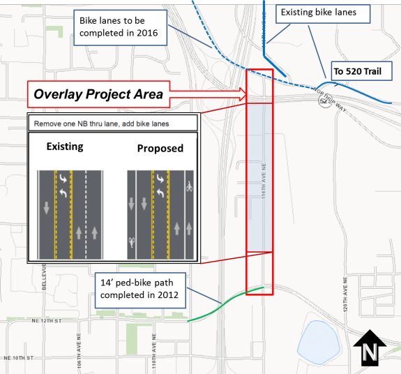
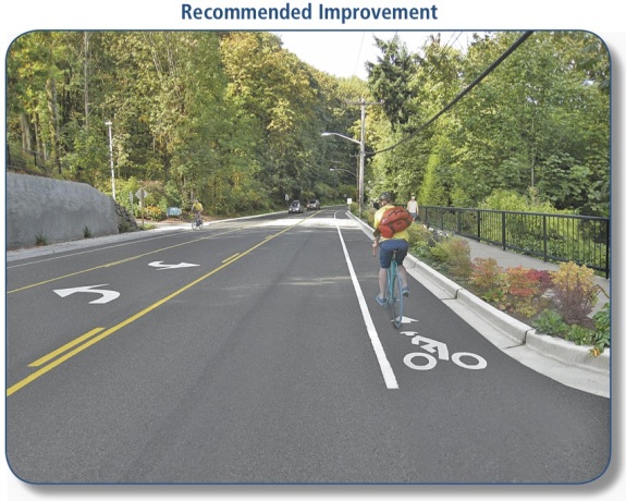
 The City of Bellevue is planning safety changes to the design of 116th Ave NE, including new bike lanes to help link the 520 Trail to the NE 12th Street crossing of I-405 into central Bellevue.
You can throw in your support and thoughts on the design at an open house 5–6:30 p.m. December 11 at Bellevue City Hall, Room 1E-112.
As we reported previously, this is a smart project that would provide a low-cost and high-impact bike connection while also making the street safer for all users.
Today, there are two lanes northbound and one lane southbound despite the fact that traffic is essentially the same in each direction. There is no significant southbound traffic issue today. Having too many lanes makes the street more dangerous for everyone and encourages speeding. Planners describe the benefits for all users this way:
Adding bike lanes in the corridor produces several benefits including creating designated space for improved cyclist safety, but it also creates benefits for pedestrians and motorists. Pedestrians will find crossing 116th Ave NE safer and more convenient over this nearly ¾-mile corridor, as the proposal would reduce the threat to pedestrians that can occur with crossing multiple through lanes. Motorists turning in and out of driveways will find it more convenient and safer to cross a single through lane.
This is a great project, so be sure to let them know you support it. You might also suggest that the bike lanes extend all the way to each end of the project area instead of stopping short.
If you can’t make the meeting, you can send your comments to Mike Ingram, Senior Planner, 425-452-4166 or [email protected] and Kurt Latt, Senior Transportation Engineer, 425-452-6020 or [email protected].
Bellevue budget includes $1 million for Eastside Rail Corridor trail
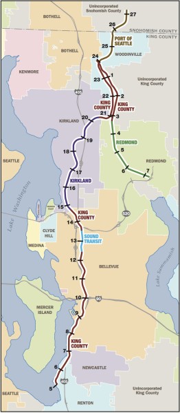
The city of Bellevue’s budget approved Monday includes $1 million to buy or least parts of the Eastside Rail Corridor from King County to start expanding the Cross Kirkland Corridor trail into Bellevue.
There is still a lot of work and funding left to go before the trail will be full steam ahead through Bellevue, but this is a key step in that direction.
Someday the trail could connect from the Sammamish River Trail (and, therefore, the Burke-Gilman Trail) to Renton through the heart of the Eastside. Snohomish County has also started planning work to extend a trail along the corridor north to the City of Snohomish.
Once the bulk of the trail has been completed — and if it is done well — the Eastside Trail could rival the Burke-Gilman as the region’s best urban trail. It could connect all Lake Washington’s crossings and pass through or near very large population and employment centers.
Simply put, this trail is a game changer. Once it is completed, the region will never be the same again.
$7 million for Newport Way sidewalks
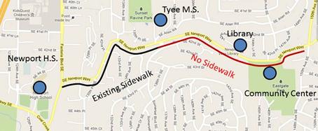
Bellevue’s budget also includes $7 million to build missing sidewalks on Newport Way in Eastgate. This project had very strong community support and connects several schools and community destinations.
It’s crazy that this road was constructed without sidewalks to begin with, so it’s great that Bellevue is investing to fix it.
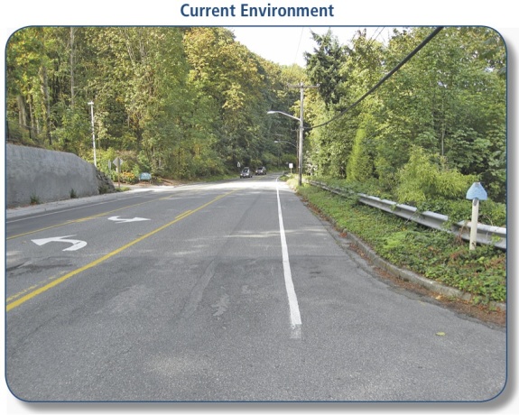
As the before and after images below show, Bellevue’s 2009 Pedestrian and Bicycle Transportation Plan also imagines bike lanes on the street some day:



Comments
16 responses to “Bellevue approves trail funding + Open house for 116th Ave NE safety changes”
This is one of the worst sections on the Seattle -> Microsoft via I-90 route, which is much shorter than the BG (~1 hour shorter from my house). I do this route in the summer mainly, but almost never in the winter because the traffic is so bad in the dark. I doubt this will make me do it more in the winter but maybe sometimes.
The I-90 Seattle -> Microsoft route:
I ride this daily year round. (in reverse as I live on the Eastside) The two big traffic problems are the Factoria hill climb (ride up SE 36th to 150th, cross straight over, then turn left into the parking lot where Albertsons is, ride out the parking lot to the North and continue on SE 37th, ride under the freeway (on the sidewalk if traffic bothers you, otherwise the road is wide enough for you and a car to pass). Then turn left on 161st, ride North to SE 24th, turn right, ride to 167th, turn right, ride through the neighborhood up to the top of the hills (I can give you turn by turn but it’s easy) pop out onto 164th, and keep riding North, to NE 30th, then cross straight over Bel-Red road and you are onto the MS campus.
Good lights (Dinonette, Blaze.ccc et.al. ) make it reasonable even in bad weather. The worst traffic is that Factoria hill climb but cars seem to be used to having bicycles on the road.
I commute from Eastgate to Northup Way a little after 164th once a week, and I also take the tunnel under I-90, 161st (sharrows, the only ones in Bellevue), 24th and whatever it becomes around Phantom lake, then 167/8/5/6/5 to Northup way. Once you’ve gone under I-90 it’s really quiet streets with no backups.
Eastgate Climb over 36th can be hard, but you usually get a couple minutes to rest while waiting at the light at Factoria Boulevard. It’s a popular bike route so cars watch out. Make sure to take the lane at the end of the bike lane right before 150th, there’s a center refuge island that doesn’t allow cars to pass you safely, but they still will try if you don’t take the lane.
140th and the BC campus is another option, though there’s a bit that doesn’t have bike lanes (520 to NE 8th).
Piece by piece, a useful network for transportation cycling on the eastside is coming together…
If Bellevue doesn’t have the resources to do their entire stretch of the ERC at once, I really hope they can stage their work to provide benefits part-way through. The stretch between 108th and the 405 underpass is critical, because it will vastly improve the connection between Kirkland’s trail and the 520 route by allowing people going from one to the other to avoid 108th. Even if the part of 108th nearest the trail had a layout that worked for the whole range of people that will be comfortable with the on-street part of the 520 route its grade would remain a real challenge. The ERC crosses the 520 route in its future on-street portion, so a simple 520-ERC connection would just use 116th and 115th Aves NE to get to where the street and rails run side-by-side under 405.
I don’t think the staging issue is as critical in any of the parts Kirkland is building today. North of Kirkland, the stretch from the end of Kirkland’s section to where it will meet Redmond’s future Central Connector is similarly important.
This trail will be a game changer for the region. Connected long routes make it possible to commute by bicycle or foot. It’s healthy and a reasonable alternative to spending billions to put in mass transit everywhere. (as much as I like fast mass transit, I’m for building out bicycle connections first.)
This would be such a welcome change. This area is the least comfortable section (in my opinion) when going from North Lake Washington to South Lake Washington. I only wish they would provide some separation in the bike lanes, but perhaps there just isn’t room.
Also, I didn’t realize there was a 14′ bike/pedestrian path on 12th. It’s not on Google Maps. I wish more people would contribute to Google Maps. I’ll add this stretch right now.
Haha, I actually do lots of bike-related edits to Google Maps… though I really wish Google got more of it right in the first place. I considered changing the cycling info for that bridge some time ago and never did because I didn’t know whether Bellevue really considered it a bike route… and I wasn’t sure it connected to the nearby streets in useful enough ways to really be much of a bike route. Then I never really went over there to investigate. I did recently add the new bike lanes under 520 on 108th/112th, and on the new stretch of NE 120th St near Totem Lake! Exciting stuff!
Those are my criteria, at least, for whether I’d call a bridge sidewalk a “separated parallel lane/trail” for the purpose of maps. By that rubric, the Fremont Bridge sidewalks qualify, because signage clearly indicates the sidewalks as a bike route and ramps support connections to the street in useful ways… and Airport Way S over the railyard doesn’t, because even though the sidewalks are much wider, all the street connections are really awkward but one (entering from the north) and it doesn’t appear Seattle considers it a bike route officially. But then if Seattle follows the BMP Implementation Plan and builds protected bike lanes from downtown to Georgetown in a few years, they’ll probably use the bridge sidewalks, and if they add appropriate signage/markings and make entering and exiting the sidewalk smoother, it would qualify.
Even without bike lanes, this road diet should have been a no-brainer given the lopsided existing layout and the hazards it creates.
While they mention the pedestrian benefit of eliminating multi-lane crossing hazards, they don’t explicitly mention any other pedestrian improvements that I can see – an overlay would seem to be the perfect time to install at least one speed table/raised crosswalk at one of the intersections near the center of the 3/4 mile stretch without a marked crosswalk.
Even a very slight elevation can help with speed limit compliance, as well as providing a clearly-marked crossing for more vulnerable pedestrians who aren’t comfortable using any of the existing unmarked crosswalks along the route.
This is great news. 116th Ave. is right along the I-90 bike route between Microsoft and Seattle, and the Northup Way bike lanes will be right along a much short route between those two areas, once the new 520 bridge is completed.
When the 12th St. bridge opened with its 14-foot bike path, it had the appearance of a path to nowhere. However, as we are now seeing, if you take care of the most expensive pieces of bike infrastructure (e.g. the freeway crossing) when the opportunity presents itself (WSDOT rebuilding the bridge anyway), given enough time, the cheaper components will take care of themselves.
Newport Way sidewalks are great! They should build both the bike lanes and the sidewalks at the same time, it’s most likely about the same cost and definitely cheaper than going back and putting bike lanes later. The street has a 35mph speed limit for most of the stretch from Somerset Blvd to 150th, which is definitely a speed limit too high to expect bikes to reach it. Going eastbound there’s a very small incline that is definitely noticeable, and it makes it so that you can’t go above 15mph. Right now there’s a 3-4ft wide shoulder on both sides which is used as bike lanes for bikes. I can’t imagine putting the bikes into traffic.
It’s interesting that the ERC ownership map drops off below mile 5 in Renton. Is it private below there, or still actively used? Some of it is probably on Boeing property.
The Lake Washington Loop south and west of there could certainly use a little work… really, a minor reroute, off of Logan.
You can track parcel ownership on King County’s iMAP GIS site.
BNSF still owns the right of way southbound starting near the north end of Gene Coulon Park.
http://www.kingcounty.gov/operations/GIS/Maps/iMAP.aspx
[…] in Bellevue: Bellevue is planning to build out more trail along SR-520 and is reviewing options for bike lanes on 116th Avenue […]
Thanks for reporting on the east side! This all sounds like great news.
The Newport Way sidewalk project also has a bike lane component. Also, the council recently changed the speed limit on this road to reduce traffic speed to 30 MPH (this will be effective once the new signs are installed). Finally, the Council also funded the missing Mountains to Sound a Greenway connection between Factoria and Eastgate, so that 36th climb will be much safer for cyclists soon.
The Council is committed to building out Bellevue’s multi-modal network which includes safe facilities for peds and bikes. Like other infrastructure, Bellevue’s approach is to fund the needs in phases as funding is available.
[…] bike news: a road diet and bike lanes for 116th Ave NE, $1m toward the Eastside Rail Corridor trail, Newport Way improvements, and […]