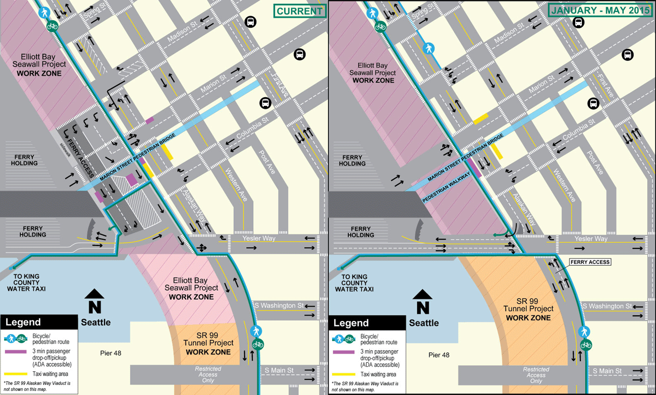
If you are among the scores of people who bike to the Bremerton and Bainbridge Ferries or the King County Water Taxis, get ready for more changes to how you get to your boats starting this month. The ongoing seawall project will need to close some space in front of Colman Dock, so detours for just about every user will switch around.
The changes probably affect people driving more than people walking or biking, but folks coming from south of the dock will no longer need to make that strange turn across temporary ferry queue lanes, though folks biking will no longer be able to access that little special cut-through to the bike-only ORCA reader.
For more details, check out the WSDOT website. Here’s a super exciting GIF:
Mercer Project on track for fall finish
The city’s giant Mercer Project is on schedule to finish on time this fall, the city announced Wednesday. Unfortunately, that means many more months of hairy detours through the construction area. But there is light at the end of the … nevermind, let’s not say that word too close to Hwy 99.
In all seriousness, this project will finally provide a quality biking and walking connection between South Lake Union and lower Queen Anne/Seattle Center. This is a really big deal, and it could even kick off a bike boom in this near-downtown neighborhood that has long been cut off from the rest of the city’s major bike routes.

Details from SDOT:
The Seattle Department of Transportation and its contractor have finished much of the construction for the Mercer Corridor Project. Construction is on schedule to continue this year with completion this fall, thanks to diligent, hard-working crews.
The final configuration will feature three lanes on Mercer Street in each direction between Fifth Avenue North and I-5, as well as new left turn lanes at Ninth Avenue North and Dexter Avenue North. The new corridor will also include a bicycle path to help connect South Lake Union and Uptown across SR 99.
In 2014, crews completed signal, travel lane and sidewalk improvements to convert Mercer and Roy streets to two-way operation between Fifth Avenue North and Queen Anne Avenue North and opened two westbound lanes on Mercer Street between Ninth Avenue North and Fifth Avenue North, providing a direct westbound connection from I-5 to Seattle Center and surrounding neighborhoods. Crews closed Broad Street at the same time to allow for the widening of Mercer Street near Dexter Avenue North. Construction of the SR 99 bridge structure over Mercer Street is also complete.
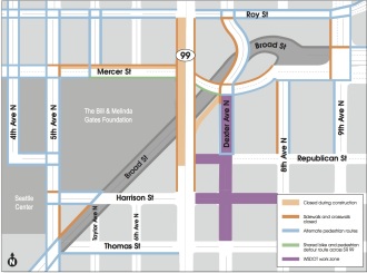
In 2015, crews will continue to work on Mercer Street between Fifth Avenue North and Ninth Avenue North, on Dexter Avenue North between Roy and Mercer streets and on Fifth Avenue North between Mercer and Broad streets. Here’s a preview of upcoming changes you can expect to see:
Pedestrian changes
· The west crosswalk on Mercer Street at Ninth Avenue North will re-open later this month after crews complete ADA and sidewalk improvements at the northwest corner of the intersection.· In the coming months, pedestrians will be routed to the north sidewalk on Mercer Street and the south sidewalk will be closed for final improvements near Dexter Avenue North. More information will be provided in advance of this change.
· Crosswalks at the intersection of Fifth Avenue North and Harrison Street are open, although intermittent closures may occur as needed for final improvements.
· The sidewalk on the east side of Fifth Avenue North will remain closed between Harrison and Thomas streets for the next few weeks as crews lay conduit and form and pour the new sidewalk.
Please obey detour signage to increase the safety of all travelers. Updated pedestrian and bicycle route maps are available on the project website, http://www.seattle.gov/transportation/mercer_schedule.htm
Vehicular changes
· Full closures of Taylor Avenue North between Roy and Mercer streets will be scheduled during daytime hours as needed to complete electrical work. These are currently scheduled through the week of Jan. 12.· A full weekend closure of Mercer Street is tentatively scheduled for early February to remove the temporary roadway along the south side of Mercer Street between the SR 99 overpass and Eighth Avenue North. Once this work is complete, the temporary curvature along Mercer Street will be removed. Look for more information in the coming weeks.
· Daytime lane restrictions on Fifth Avenue North and Mercer Street will continue as needed.
The project team wants to thank everyone for their continued patience throughout construction in 2014. As a reminder, questions and concerns can be sent to [email protected] or our 24-hour construction hotline (206)-419-5818.


Comments
5 responses to “Bike access at Colman Dock changing soon + Mercer Project on schedule for fall finish”
It’s already super convoluted and dangerous to ride through here now as it is. These regular changes make things very difficult because the minute you get used to one configuration, something else changes.
Separately, heres a good idea for a story you should pursue related to the convoluted 5 way intersection at Chelan and Spokane in West Seattle. Looks like they are proposing a solution that doesn’t help with the signal timing, but adds lots of paint.
http://westseattlebikeconnections.org/files/2015/01/15-1-7-SBAB-WS5Way.pdf
I wish we could route the bike path across SW Spokane St at the signal just across the bridge, along the SW edge of the W Marginal Way flyover and then add another flyover from there to the Alki trail over Chelan Ave. Would be more $$ but a lot more helpful than trying to social engineer that mess of an intersection.
Oh heh, that’s the same idea as their long-term plan. Cool.
This morning, arriving on the Vashon Water Taxi…once cyclists (who usually unload last from the WT) get to the end of the dock, where we used to be able to access the street system fairly quickly, cyclists are shunted along with all the pedestrians to the new intersection at Yesler/under Viaduct. There are two traffic lanes exiting Colman terminal, directly adjacent; one lane for left/straight and one lane for straight/(right?) motor vehicles and cyclists. However, those using the WT are separated from the lane access by a rope barrier.
Today it was kind of a free-for all as a cop was directing traffic at the new intersection so it turned in to an “all walk” while departing ferry vehicles were stopped. I, and several other cyclists, moved under the rope to get to the traffic lanes (much more open and better access to move through the intersection). Once there is no traffic direction, and if the ferry is unloading, this will be difficult for cyclists to navigate to gain street access (if they use more barriers than just the rope barrier which I suspect will happen. If cyclists end up routed with pedestrians then accessing the viaduct route northbound will consist of waiting for walk signals to cross the ferry exit lanes northbound, then wait for the next walk light to make a left turn. Or, wait in the middle of the crosswalk in front of the left turn lane for a green light. None of it very good, considering the amount of pedestrians in that area.
I wasn’t able to get an idea of how long the light cycles are (they are abysmal for pedestrians and cyclists needing to cross under the viaduct already and I don’t hold out much more hope for this intersection) and I couldn’t get a grasp on how much room there was for cyclists to wait for a light, with pedestrians, at the northwest corner of the intersection. The southwest “wait” area was small and thus, due to the people crush, I think the traffic director went for getting the mass of people out of there.
Coming southbound may be a bit easier in the evening, simply ride under viaduct to Yesler, make sure that one is not right-hooked by drivers at any location, and ride to southwest entry point after crossing Yesler. Watch out for pedestrians darting across intersections and streets!
Important: southbound under viaduct…one block before Yesler….get in right thurn lane if you want Colman dock. Move into left lane if you want Water taxis or to continue south. This is NOT detailed at all on maps!