Rainier Avenue will be safer by the end of the year.
Every option the city presented (PDF) at a public meeting Thursday evening in Columbia City included a significant redesign of the notoriously dangerous street. And the city is not going to wait long to take action.
Some signals and signage changes will roll out this spring, followed by some more significant safety upgrades starting in the summer and going into 2016.
Before we get into the solutions, let’s follow the city’s lead and outline the problem.
Jim Curtin and Dongho Chang of SDOT did a very good job explaining, step by step, why the street is so dangerous and how — though genuine community input and thoughtful design changes — the city will move quickly to dramatically increase safety on the busy commercial and neighborhood street.
The big crowd at the meeting seemed very receptive to the ideas the city presented and strongly in favor of safety changes. Cheers rang out when Curtin announced plans to lower the speed limit to 25 mph through the Columbia City and Hillman City business districts. People also cheered when Curtin said they will lengthen the crosswalk signal times. As we reported previously, a study found that traffic signals in Rainier Valley give people less time to cross the street than Ballard.
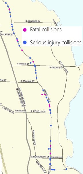
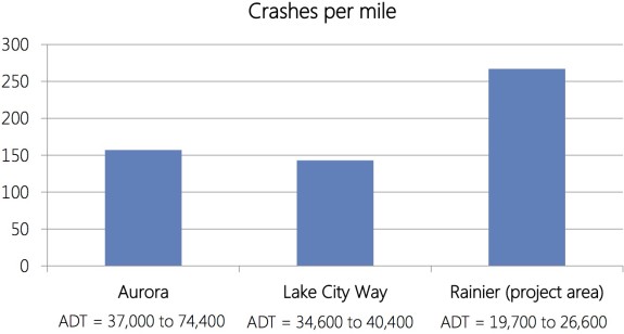
When Curtin showed the slide below, the crowd gasped. Rainier is way more dangerous than it should be, and it has been this way for a long time.
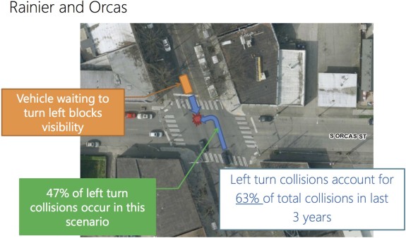
 So how are these collisions happening? Traffic studies found that half or more of the collisions happen like this: Person trying to make a left turn cannot see around oncoming left-turning cars and make the turn in front of a car continuing straight.
 A huge number of the incidents where someone driving hits someone walking happens at driveways and parking lot entrances. Often, these are people quickly making stressful turns across the two oncoming lanes.
And Rainier collisions have an outsized injury and death rate in large part due to the rampant speeding on the street. The odds and severity of injury increase dramatically with every extra mile per hour.
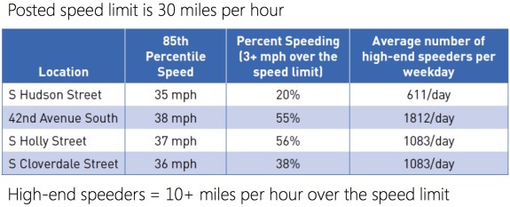 All these collisions and the problem of speeding can be significantly reduced by adding a center turn lane and reducing the number of general travel lanes people need to cross. And that’s exactly what the city plans to do.
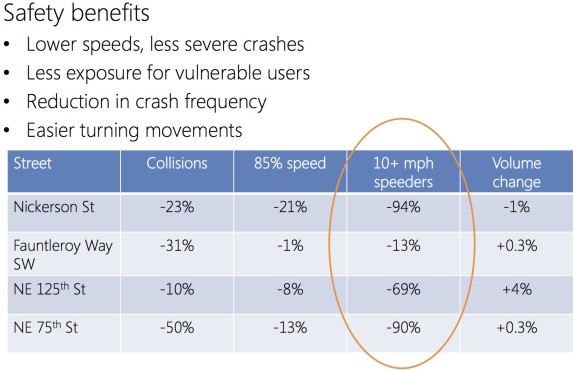 The city’s history with redesigns like the one proposed on Rainier is overwhelmingly positive. The most recent and most comparable example — on NE 75th Street — reduced collisions by 50 percent and reduced high-end speeding (at least 10 mph over the limit) by an astounding 90 percent. NE 75th Street is also a good example because it carries an almost identical number of vehicles per day as Rainier (about 20,000).
And though people might worry that reducing the number of through-lanes could push people driving to side streets, these redesigns consistently show that car traffic levels remain essentially the same (and if bike lanes are included, bike volumes go way up).
So redesigning Rainier to have one lane in each direction and adding a new center turn lane is the plan for sure. Now the city is trying to figure out the details.
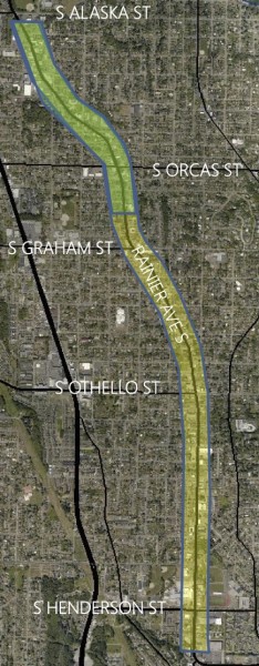
First off, this project only bites off the four-mile section of Rainier between Charlestown/Letitia and Henderson. Of that four miles, the city’s initial concepts do not include a full redesign of the northern section from S Charlestown Street to S Alaska Street. This section — which sees higher traffic levels than the section south of Alaska — would get some changes to help prevent dangerous turns into driveways, but would remain four or five lanes wide.
The redesign would begin at S Alaska and head south all the way to S Henderson. One option (1b) would include protected bike lanes through Columbia City and Hillman City. Of course this prompted people at the meeting to ask the obvious question: Why not include bike lanes for the entire street?
Another option (2) would not include bike lanes, but would add some bus lanes in key locations to help keep Metro’s Route 7 moving. The 7 is one of the busiest bus routes in the city, carrying 11,000 people every day. It needs to run quickly and efficiently since ridership will only grow as more people move to the neighborhood.
The proposed changes will effectively not impact travel times. Initial models suggest an increase of two minutes during peak hours only, but this includes slowdowns due to the lower speed limits. When a member of the crowd asked attendees for a show of hands about support for lowering the speed limit, nearly everyone raised their hands.
Our suggestions
First off, this project is a huge deal. I have not been able to stop smiling since the meeting last night. There were so many great suggestions from community members, and the conversation was one of the most fruitful neighborhood safe streets discussions I have ever been part of. It is clear that the Rainier Valley community wants to make this street work better for everyone, even if that means a significant street redesign. This Rainier Ave meeting was refreshing, engaging and filled with hope.
The core of the project is spot on: Reduce the number of lanes, reduce speeds, provide safer and lower stress turns, add times to crosswalks and reduce the number of lanes people need to cross. Like Curtin said at the meeting, “This is what Vision Zero is all about.”
Getting the exact details of the redesign is going to take work, and it’s going to require trade-offs. Bus reliability is vital. Further improving crosswalks is vital. And providing a safe space for people on bikes is vital.
Rainier Ave is one of those streets that cuts its own path through the street grid. It also follows the least-hilly route through a neighborhood with some significant geographic challenges. And, finally, it connects tons of community centers, schools, parks and businesses in a way that no other street in Rainier Valley does. A lot of people already bike on Rainier for all these reasons. Whether you’re commuting to downtown, transit routes on I-90 or just trying to get from Bike Works to Rainier Valley Food Bank, Rainier Ave is the only street that really makes sense.
How exactly does this all work out on Rainier? I don’t have all the design details, and neither do the planners at this time. Thursday’s meeting and the meeting Tuesday 6 to 8p.m. at the Ethiopian Community Center are about presenting the basic concept for a redesign and gathering community feedback.
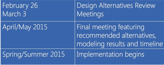
The city will then go back and further develop and analyze the options, bringing the results back in the spring:
 The city should include an ambitious redesign that includes the safer three lane design for the entire project length from Charlestown to Henderson. They should also look into a design that includes both bike lanes for the entire project length and bus efficiency improvements to keep the 7 running on schedule. This could mean increasing that two-minute drive-time delay a little (and increasing the budget), but the benefits of a truly complete Rainier Ave would be immense.
Today, Rainier Ave is the city’s worst neighborhood street. But it could be the best.


Comments
25 responses to “Rainier is the city’s most dangerous neighborhood street. But it could be the best.”
Great review Tom of the fantastic presentation last night by Jim Curtin and Dongho Chang! 1B is looking good but it could be better. If I may make a plug…
Join Rainier Valley Greenways and Cascade Bicycle Club in advocating for:
1) Safe Speeds of 25 MPH along Rainier Avenue South and 20 MPH engineered in our community centers of Columbia City, Hillman City, and Rainier Beach with enforcement.
2) Safe & Dignified Crossings of Rainier Ave S where people driving stop for people walking, and people walking have enough to time cross before the traffic light changes.
3) A Safe Place for People to Bike on Rainier Ave S.
By signing on here: http://seattlegreenways.org/neighborhoods/rainier-valley/
*neglected to mention that Bikeworks, Feet First, and Rainier Riders are also involved.
The section of Rainer from Seward Park Ave South to the Renton Airport was given a road diet 10 years ago. It would great to continue that all the way North to Dearborn. It would give us a nearly flat ride from Renton to Seattle with plenty of destinations along it to ride that route.
Since I’ve lived here I’ve looked for a way to get around taking Dearborn, but Dearborn really is unique because of its grade. Rainier is much the same (but everyone avoids it anyway, especially near I-90). Dearborn-Rainier is not only the only flat route between downtown and the Rainier Valley, it’s the only route that doesn’t involve really steep hills.
Unfortunately the place where Rainier’s grade is most advantageous is right around I-90, where traffic volumes are highest. Making it a good bike route would require pretty high degrees of traffic separation, even grade separation with ramps. That’s obviously way beyond this project’s geographical scope anyway.
Rainier is sort of like Delridge in having an advantageous grade, some notorious sections, and some tamable sections, and like Delridge, cycling improvements to the tamable sections will see limited use if the notorious ones stay as they are.
I hope that SDOT can take a ‘regional’ approach, and look at what can be done to improve safety on Lake Washington Boulevard in case drivers start bypassing Rainier backups. At present, drivers violate the state law against passing when there are oncoming vehicles, squeezing between the center line and cyclists, so they don’t have to slow down. I can see that getting worse.
Yes, that is maddening! They need to stripe the center line as double yellow. It’s insane that it is dashed for passing when it’s a slow boulevard with lots of blind curves. Here the google street view car documents its own driver in that very act, exactly parallel to the section of Rainier described above!
https://www.google.com/maps/@47.562016,-122.267654,3a,75y,160.96h,58.03t/data=!3m4!1e1!3m2!1sGO5zP5J5E-j-GAzsJWUJBQ!2e0
The driver squeezes past a cyclist while approaching a curve, just as an oncoming car approaches in the left lane. That kind of criminally negligent behavior has got to stop.
It’s legal to cross a double-yellow to pass people biking. The rationale is that people typically bike much slower than they drive and thus take less time to pass. Of course you’re still supposed to make sure you can see far enough ahead to make that pass safely…
Instead of trying to stop passing entirely, which would be sort of ridiculous, we should consider the standard practice of using standard street markings (and maybe signs) to restrict passing where curves and hills limit sight lines. On a lot of our minor arterials little thought is given to passing, but LWB’s popularity as a bike route makes it more common. Though this sort of striping probably wouldn’t change the law for passing cyclists I bet it would influence behavior.
In the past, the State Patrol said it was definitely legal to cross a double-yellow to pass a bicycle, but they don’t seem to be giving the same advice now.
The problem is that the law says you can cross a double-yellow to get by an “obstruction”, but there’s no legislative definition of what an “obstruction” is for purposes of this law.
It certainly makes sense to be able to cross a double-yellow if the speed limit is 50 and a bike is going 10 — the double-yellow is designed for the sight distances needed by a driver doing 50 passing a driver doing 48, spending a very long time over the centerline.
But what about a bicycle doing 20 in a 25 mph zone? Is that bicycle going 5 mph under the limit still a stationary obstruction, or is it now the sort of vehicle the double-yellow is intended for?
BTW, I was referencing RCW 46.61.125(1)(d), which the WA DOL cites in their “Share the Road” rules handout: “Do not pass bicyclists if oncoming traffic is near. Wait as you would with any slow-moving vehicle. It’s required by state law [RCW 46.61.125 (1)(d)]”. There’s only one double-stripe line on the Boulevard that I know of, at a short hill and blind curve by Coleman Park. Drivers ignore it all the time.
RCW 46.61.130 establishes double-yellow center lines as no passing zones, but it also specifically says the no-passing rule “does not apply under the conditions described in RCW 46.61.100(1)(b)”
Those conditions are:
(b) When an obstruction exists making it necessary to drive to the left of the center of the highway; provided, any person so doing shall yield the right-of-way to all vehicles traveling in the proper direction upon the unobstructed portion of the highway within such distance as to constitute an immediate hazard;
So DOL’s advice, “Do not pass bicyclists if oncoming traffic is near“, would still apply even if a bicycle is an “obstruction” that allows you to cross the double-yellow under RCW 46.61.100(1)(b), because even with an obstruction, you can only cross the double-yellow if there isn’t oncoming traffic.
Also worth noting, while RCW 46.61.125(1)(d) says drivers may not drive on the left side of the roadway
“(d) When a bicycle or pedestrian is within view of the driver and is approaching from the opposite direction, or is present, in the roadway, shoulder, or bicycle lane within a distance unsafe to the bicyclist or pedestrian due to the width or condition of the roadway, shoulder, or bicycle lane.”
this protection has the same exceptions as a double-yellow center line,
(2) The foregoing limitations shall not apply upon a one-way roadway, nor under the conditions described in RCW 46.61.100(1)(b), nor to the driver of a vehicle turning left into or from an alley, private road or driveway.
Great News!
Question: Does the Rainier Ave Project mean the Bar has been raised by the City, concerned neighborhoods and advocacy groups? I hope so for other “concerned” areas like Lake City Way and such!
Yes! We should see Lake City Way being addressed in 2016.
I just biked from Capitol Hill to Seward Park last night, for the first time in 3 months. I had forgotten what an absolute shit show Rainier Avenue is for biking. If the never ending stream of pot holes and ditches along the southbound right hand lane don’t kill you, then the steady mob of idiots driving 50 mph + along the road will.
[…] The Seattle Bike Blog’s Tom Fuculoro has another recap of last night’s SDOT meeting: […]
There’s some good discussion about this plan happening at columbiacitysource.com if anyone wants to chime in.
Some folks still need some convincing.
Also, one day after the meeting, another car slammed into a building in Hillman City during rush hour.
Or you might say another idiot operated their car in such an insanely reckless way that they drove it straight into a storefront. Cars don’t drive themselves, except a few in Mountain View, and when they do, they don’t jump the curb, so far at least.
Just read through the Columbia City Source comments. It’s not “some folks” that need convincing, as the only voice of discontent in there is that of Ray Akers, who has a long history of virulently opposing sensible ideas in the SE. There’s no use trying to convince him, so just move along with your day.
[…] Please fix it: Just how dangerous is Rainier Ave S? The answer is: very. On a per mile basis, it has almost 100% more collisions than Seattle’s next most dangerous street. Of course, it could get a whole lot better. […]
Great article Tom. Here’s to that hope carrying over and saving future lives.
[…] The good news is that these concepts are not new in Seattle. Seattle Neighborhood Greenways and Cascade Bicycle Club are at their best when they help build strong local safe streets groups led by and working with a wide variety of neighborhood leaders and organizations. For example, the community building work of Rainier Valley Greenways has been vital in building support proposed safety changes on Rainier Ave. […]
[…] than most Seattle streets. It’s even busier than most of the Rainier Ave sections the city is currently studying for a similar road safety […]
[…] about the city’s lack of action in September helped push the city to create and expedite a road safety project, which will begin rolling out safety improvements soon. But it’s going to take a lot more […]
[…] 2 covering Rainier Valley — was fired up about a safer Rainier Ave and in strong support for city plans to redesign the street this summer. Those plans would calm traffic speeds and reduce collisions by adding a center turn […]
[…] in South Seattle seems to be a popular topic these days. Everybody has something to say about the Rainier Avenue road diet. Chief Sealth provides one opportunity for safe non-automobile travel in […]