35th Ave SW is not an Interstate. It’s not even a state highway. So when neighbors refer to this city street as “I-35,” you know there’s a serious speeding and traffic safety problem.
And those neighbors are not being as hyperbolic as it sounds. There is a collision every couple days on 35th Ave SW. Someone is injured every week.
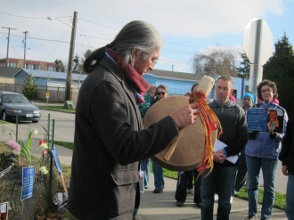
And in the past decade, five people have died. One of those people was James St. Clair, who was killed while walking across the street a few months ago. Family and neighbors gathered in January to walk in his memory and call for safety so nobody else is killed or seriously injured on this notoriously-dangerous street.
West Seattle resident and City Council Transportation Committee Chair Tom Rasmussen was there, too, and he called on the city to study the street and recommend solutions. The Road Safety Corridor team got on the case and reported their initial concepts (PDF) for safety changes this week (see coverage of Tuesday’s meeting via West Seattle Blog).
All options would significantly reduce collisions, speeding and serious injuries on 35th. Neighbors may need to retire the name I-35 when the changes go into effect later this year and early 2016.
You can learn more at their second meeting 3:15 – 5:15 p.m. Thursday at the Southwest Library Second Floor Meeting Room.
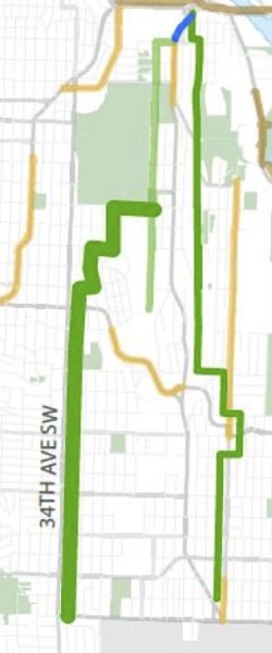
35th Ave SW is on the Bike Master Plan, which recommends protected bike lanes from Fauntleroy all the way to the city limit. However, the city is not considering bike lanes in either of the options presented, citing “public comment.” Instead, they will accelerate building a neighborhood greenway mostly on 34th Ave SW, though the initial route presented would not connect to the Junction like 35th does. The city will study it in 2016 and build it in 2017.
Don Brubeck of West Seattle Bike Connections said the group does not consider 35th Ave SW bike lanes a high priority (though there was some dissent within the group on this point).
“We have other battles we’re trying to win,” said Brubeck, citing city plans to fix the large intersection connecting the Alki Trail to the West Seattle Bridge and the need for bike lanes on diagonal streets.
“Angled streets are much more difficult to find parallel routes to,” he said.
However, 35th Ave SW is the most direct and flat route through this part of the neighborhood from the White Center border to both the Junction and the West Seattle Bridge.
It’s a concerning precedent to set that facilities recommended in the Bike Master Plan would not even make it into the studied alternatives.
Below is a quick look at the options, from SDOT’s presentation (PDF):
First off, the speed limit will be reduced from 35 mph to 30. Reports from the initial meeting said attendees cheered when this was announced.
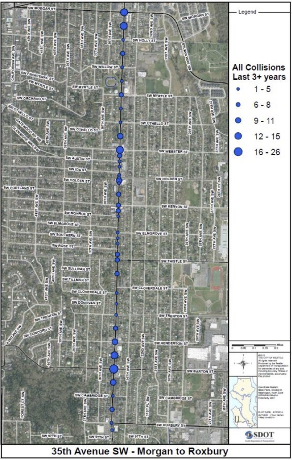
That’s probably because attendees are well aware of how dangerous I-35 is. Sure, it’s not quite as dangerous as Rainier Ave, but that’s a ridiculously high bar. Like Rainier, however, collisions happen along the entire route pointing to a core problem with the street’s design:
 Traffic volumes are pretty high up near Alaska, but they fall off as you head south. This graph show Average Daily Traffic at various points:
 Alternative 1 would change the entire project area from four lanes to three, including a new center turn lane:
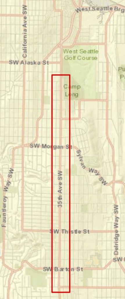 Alternative 2 would only apply the changes south of SW Raymond. Initial modeling suggests that this limited change would only save about a minute on travel times during peak hours. (Alternative 1 would add 3–4 during peak, Alternative 2 would add 3)
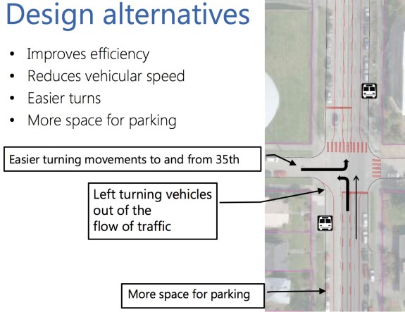 In essence, the street would have wider spaces for on-street parking on both sides, one lane in each direction and a new center turn lane.
But this design will only improve safety if there is enough parking demand to actually fill those parking lanes, which I doubt is true (a quick glance via Google Earth shows very low parking usage for much of the project area). If parking demand is low, it would be safer for everyone to build bike lanes to make sure the city does not essentially create dangerously-wide travel lanes. Wide lanes encourage speeding and make it more difficult to cross the street.
If bike lanes are not included, the city should at least consider a 25 mph speed limit so the street is a little safer for people who choose to bike on 35th.
I understand that bike lanes on 35th might not be West Seattle’s highest bike improvement priority. There are many challenging streets in the neighborhood. But the city is investing time and money right now to make this particular street safer, and it would be a missed opportunity if we fail to take action now to prevent a tragedy. For a variety of reasons (because it is the most direct or they don’t know another route, etc), people do and will continue to bike on 35th whether there is a neighborhood greenway nearby or not. We should not leave them out of a safer 35th Ave SW.


Comments
26 responses to “Safety changes — but no bike lanes — planned for I-35”
“First off, the speed limit will be reduced from 35 mph to 30. Reports from the initial meeting said attendees cheered when this was announced.”
Does it matter if the speed limit is 35, 30, or even 50 if it’s never enforced? I hardly ever see people driving the current speed limit on 35th, so I doubt they will when it is reduced to 30 mph.
…unless of course you put in some speed cameras! Dare to dream.
It matters if the road is re-engineered to make lower speeds feel comfortable to drivers, and that’s exactly what Dongho Chang said when this question was asked during the meeting.
Yeah I am not sure I agree with this. I am continually surprised when I see one cyclist a month using 35th. The fact is the alternative routes near it are far better than the limited direct routing 35th offers, due to the fact the grade and site lines on 35th are generally terrible.
The only people who appear to use it are between alaska and morgon, due to the lack of surface routes blocked by the golf course and Fairmont park.
Ditto on enforcement, its terrible in the area, especially on surface streets people use as bypasses.
While 35th is not the nicest street in West Seattle, I ride it to get to High Point library and surrounds. I ride on the street but also see many other riding sidewalks, which are rough, dangerous and uncomfortable. I broke my wrist on my bike when I hit a nasty pothole there. If we had a lane, that would be better. All that said, it isn’t the highest priority in West Seattle.
West seattle is a car culture suburban wasteland where high speed driving and threatening and assaulting people who don’t conform to that ideal is the norm. Forget bike lanes, just avoid the place entirely.
Super helpful comment! Thanks for contributing!
I hope you realize how stupid and useless your response is. If not, sit down and think about it for a while.
tit for tat, my friend.
Cheif, do you live in West Seattle, or have you visited it recently? Your comments suggest you are out of touch with reality. SDOT briefed that transit ridership is up 40% in West Seattle in the last three years. People are filling up West Seattle’s new apartments, apodments, backyard dwellings and condos, but concurrently, as SDOT briefed, traffic volumes on 35th SW have held steady over the past several years, and most of the increasing traffic delays in our district are due to backups across the West Seattle Bridge, likely caused by traffic on Hwy 99 and I-5. High speed driving on residential arterials like 35th Ave SW is encouraged by a highway-style road design. This behavior is not specific to West Seattleites as proved by the dramatic reduction in speeds and collisions after the safety design implementations on roads like Nickerson Street, NE 125th Street and NE 75th Street. I know, troll feeding….
As someone who lives on 35th (and commutes in and out of WS by bicycle), I am a bit disappointed that the bike facilities outlined in the master plan didn’t make the design alternatives. Also, I haven’t been terribly stoked on WSBC’s stance, but agree there are more pressing issues in WS such as improving the bike connections in and around the Alki Trail. Without a doubt, WSBC has done, and continues to do, great work in and around WS.
I’ve also come to understand that people of all ages and abilities will still likely feel uncomfortable bicycling on facilities built on arterials, and that parallel greenways on 34th and 36th may be a better solution when the ultimate goal is to get more people bicycling.
I’ll never miss an opportunity to say I-told-you-so, so here I go: Back during the BMP update I mentioned many times that the plan is ultimately not very important. I said, look, during the last 5 years of the original BMP what happened? Some items in the plan were implemented, most things in the plan were not implemented, and many things that weren’t in the plan got implemented anyway.
I’m not from that area, by my vote would be to have a Greenway one block over and forget the bike lanes on 35th Ave. Switching from four lanes to two lanes plus a turning lane will be a huge safety improvement but cars will still speed and collisions will still occur, especially at intersections where car-oriented West Seattle-ites don’t exercise proper care.
The whole deal with the BMP map (as opposed to, say, the implementation plan) is that a line on the map represented the importance of a needed connection more than a commitment to build a particular kind of facility. That’s why, for example, it was so insulting (and meaningless) for the anti-bike contingent in Ravenna-Bryant to agitate against the plan.
Exactly. That’s precisely why I was so un-interested when folks would freak out whether their particular street or intersection did or did not make it into the plan. It makes very little difference. What does make a difference is neighbors organizing, writing grants, building community support, talking to SDOT, and pushing for change in a particular place. This can all happen with or without the BMP.
So when I hear “But 35th was in the BMP!”… I just don’t understand why people think that makes a difference. It’s just a glossy document with lots of pictures but no commitment or funding.
Tom, I totally understand your concern about wide travel lanes encouraging speeding. You’ll be happy to know that I was at the Tuesday night meeting and spoke with both Jim and Dongho afterward, and they both confirmed that the city is planning to have narrow travel lanes to help reduce speed. This is part of the reason for widening the parking lanes.
Jim also intimated that bike facilities may well be added to 35th at a later date, as a complement to the proposed greenway on 34th.
“But this design will only improve safety if there is enough parking demand to actually fill those parking lanes… If parking demand is low, it would be safer for everyone to build bike lanes to make sure the city does not essentially create dangerously-wide travel lanes.”
One alternative, used elsewhere, is to put buffer striping in the door zone next to the parking lane.
NCHRP 766 says the typical width of parking plus door zone for standard passenger vehicles extends eleven feet from the curb — striping the door hazard improves safety for people getting out of cars, reduces dooring risk for people on bikes, visually narrows the travel lane, and makes it clear that the parking lane and door zone are not a legal travel lane.
All without taking away on-street parking or striping yet another door zone bike lane.
Or, simply put in planter bulb outs at regular intervals in areas where there is not enough parked cars to create a calming effect.
That map of the “planned neighborhood greenway”, which also shows up in the PDF document, appears to show a new greenway down Brandon St., past Camp Long, and to the existing greenway on 26th. I couldn’t find any more info about this, either in the document or with another quick Google search. Anyone know more about this?
If a greenway on 34th, and then down toward 26th, is to be the major bike route in this corridor, another bike route toward Alaska Junction from High Point (and areas south of there) is needed. East-west routes from Camp Long to the Junction that don’t involve riding on 35th have really wacky hills on them. Heading west from High Point on Graham, Raymond, or Morgan is more reasonable; then we’ll have to develop a north-south route in the vicinity of California, which we need to do anyway.
How about from High Point on 36th SW south of SW Hudson (at Mount St Vincent) and 37th SW north of SW Hudson to SW Alaska? steep down to Alaska, but so is everything else west of 35th. Or, if going further west from High Point, take SW Graham or Raymond west to 42nd SW to SW Alaska, then west to 44th or 45th SW and north to Admiral and Alki.
I think the hills are much more favorable if you head west at about Graham then north somewhere around California — the block of 37th immediately south of Alaska is particularly steep. You also avoid going through the Alaska/Fauntleroy intersection, and avoid having to turn left from 37th to Alaska, which is no picnic when traffic is heavy. To get over to California-ish down at Graham-ish you have to cross Fauntleroy, but it’s a lot smaller there than it is up at Alaska.
I could have this all wrong, and you surely have more local knowledge — I’ve biked on most of these streets (and walked and run on some, too), but only a few times since I don’t live in West Seattle.
Different places require different solutions and on-the-ground local knowledge, not ideology.
The big win here is that SDOT committed to do a parallel greenway several years ahead of the work plan schedule announced just a few months ago. Routes on 34th, 36th and 37th immediately parallel to 35th provide great links for all ages and abilities, including great commuter routes on 34th, that link residential neighborhoods to several public, private and parochial schools, two public libraries, community center and Neighborhood House at High Point, playfields, parks, and shopping areas in White Center, Morgan Junction and West Seattle Junction, with links (via steep hill) down to 26th Ave Greenway and Delridge. Unlike the diagonal streets like Fauntleroy, Admiral, Avalon, there actually are parallel routes along 35th that work. 34th on the south half has veru reasonable grades. 36th/37th have some steeper areas that are not really AAA, but you cannot avoid some hill climbing in West Seattle.
We want SDOT to spend the big bucks first in West Seattle on the Fauntleroy Boulevard Project and protected bike lanes further south, the Chelan 5-way intersection flyover, PBL’s on East Marginal Way S, and other more problematic areas. The city cannot do everything everywhere at once. We need to be strategic in what we ask for, and push for more important things first, and not enrage our communities. That is why in 2012 West Seattle Bike Connections, with many West Seattle people involved, told SDOT that the Bike Master Plan Update should not include PBL’s on 35th, but should include the parallel routes.
SDOT disregarded that particular community input from people actually riding these streets then, but it is still valid. That street has high volume traffic, up to 25,000 ADT at the north end, and 73% of the frontage is residential with need for parking and bus stops in the curb lane and not enough roadway width for more than 2 general purpose traffic lanes, a center turn lane, and the parking/bus stop curb lanes. With the proposed Alternative A, the curb lane does get a foot wider each side for most of the length of 35th, and cars will be able for parts of each block to edge into the turn lane to pass cyclists, so for the intrepid souls who ride on 35th there will be more chance to stay out of the door zone. We want the lower speed limit and the safety improvements at intersections to give people safe crossings of 35th on foot or bike or wheelchair. This is an important transit street, with the C-line, the 120 and other lines running at frequent headway.
Please support the West Seattle community for this project by telling SDOT that you think Alternative A is the best solution, and that it should be implemented this year. Please contact Jim Curtin at 206-684-8874 or via e-mail at [email protected]. We need to counter the outrage and input of those who think their God given right to drive as fast as they can until the traffic backs up is being trampled on by the government.
One more thing. Tom, “(a quick glance via Google Earth shows very low parking usage for much of the project area)”. But this is primarily residential parking. If Google Earth could take its pictures in the dark when cars are back home, you would see a different picture.
I agree with Don and WSBC as a whole about this area. I’d rather see some intersections fixed and major problem areas fixed first – which are major LINKS in the bike commute to/from West Seattle.
I used to live close to 35th and rode N/S along this corridor frequently.
Rarely did I ride 35th (unless very low traffic) and I don’t think I would even with bike lanes. I don’t trust the drivers at all.
South of Morgan, 36th is a super great route with very little vehicle traffic. The only sticky point is the one really steep block between Alaska/Edmunds – which is unavoidable even on 35th. To avoid this climb one has to use Fauntleroy and snake up the hill to 35th via Findlay/38th.
Then one can cross using Graham or Morgan (Morgan is signalized but watch for turning/close passing vehicles) to 34th all the way to Westwood/Roxbury.
Al Dimond, I think you are calling out a good route, using Graham to near California to go to WS Junction or Admiral or Alki. That’s the route using 42nd SW to SW Edmonds or SW Alaska I mentioned. We and High Point neighbors and Seattle Neighborhood Greenways want to see a full signal at Graham to make this plan work.
Yeah, that would be a good route to emphasize… and one that fits in well with a comprehensive greenway network.
I don’t think I’ve ever taken 42nd — I imagine an excellent bike facility on California itself would be unlikely, given the importance of parking and transit there (sort of like 45th in Wallingford).
[…] Street safety: West Seattle will get safety changes on SW 35th Ave, but bike lanes like won’t be part of it. […]