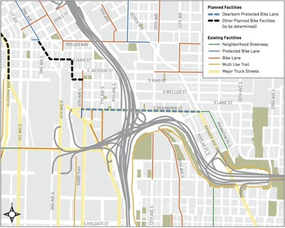
 Dearborn Street is both flat and useful. So even though it is not packed with destinations itself and though it serves the motor vehicle network mostly as a way to access I-5 and haul freight, it is also a highly desireable bike route. It connects downtown neighborhoods to bike routes in central and southeast Seattle, as well as the I-90 Bridge.
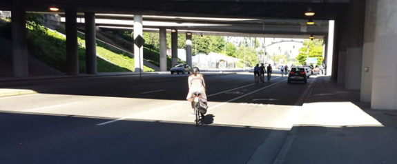
But today, Dearborn only has a very skinny bike lane squished far off to the side of the street next to very fast-moving traffic. And at key points where Dearborn meets busy streets or highway ramps, the bike lane is either inadequate or disappears entirely.
That could change in a couple months as the city plans a major bike lane upgrade.
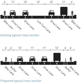
 The crux of the design of a wider bike lane with a wider buffer space from traffic, lined with reflective plastic posts. To put the improvement in context, the four-foot buffer alone will be as wide as the entire old bike lane. Especially since nearly every person driving is going at least eight mile per hour over the speed limit, more separation is vital both for safety and comfort.
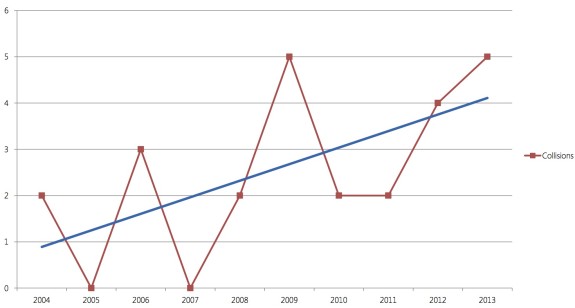
In just five years (2009–2013), there were 175 collisions on this 0.76-mile section of Dearborn. 19 of those collisions involved people on bikes. This number is growing in large part because the number of people biking on Dearborn has been increasing while the number of people driving has been decreasing (down 25–30 percent in the past 20 years).
The goal of the project is to connect the neighborhood greenway bike route on Hiawatha Pl (which connects to the I-90 Trail) to 6th Ave S, an existing bike route leading into the heart of the International District.
No bike lane can change the fact that Dearborn crosses through a freeway interchange wasteland, but having a protected space to navigate this challenging area is a big deal for activating existing bike routes. Better yet, the neighborhoods most helped by this connection are in southeast Seattle, where quality bike connections to the city’s employment center have lagged most.
It also sets the stage for what may be the single biggest missing piece of bike infrastructure in the whole city: Protected bike lanes on Rainier Ave (that is not yet on the city’s schedule for bike lane work, so it’s gonna take a lot of grassroots work to make it happen).
UPDATE: Below are some design images from a July presentation to the Seattle Bicycle Advisory Board.
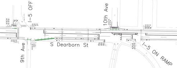
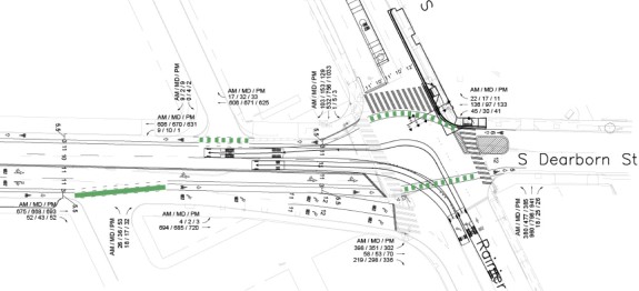 Unfortunately, the bike lanes will not be perfect. They will still need to cross highway ramps, and there won’t be new signals to control that maneuver. Places where ramp traffic crosses the bike lanes will be better marked with green paint, but this probably will not achieve the city’s all-ages-and-abilities goals for bike routes.
Another big problem: The route still will not connect to downtown because there is no good bike connection between the International District and downtown. Plus, 6th Ave only has a bike lane southbound, making it an incomplete connection on its own.
Dearborn is a big missing piece, but it’s not enough.
The good news is that the city plans a connection via 5th Avenue and S Main Street as part of the Center City Bike Network. That connection is currently planned for 2016 implementation.


Comments
29 responses to “Dearborn bike lane improvements will connect downtown to I-90 Trail, SE Seattle bike routes – UPDATED”
I look forward to this since Dearborn is on my daily west Seattle – Bellevue commute.
I’m curious how you navigate that – what’s your route from the WS bridge to Dearborn?
I am happy to see they will be making this improvement. Honestly, I don’t think the bike lane is even 4 feet wide on the eastern section of Dearborn. I would be surprised if it’s even 3 feet wide.
Also, I’m surprised Hiawatha Pl S is considered a greenway. There is an uncontrolled intersection with a roundabout that cars drive through without even slowing.
Looking forward to the Dearborn change though!
Assuming the bicycle lane pavement marking is a standard 40-inch width, most of the Dearborn bike lanes today are just barely wide enough to contain that marking.
In some places, the bike lane marking and the lane stripe overlap, so the lane is less than 40 inches wide. (Note that official bike lane width is measured to the center of the bike lane line, not the clear width between the line and the curb, so it might actually hit 48″ in a few places.) The bike lanes used to be a little bit wider, you can still see the remains of the old stripe hanging out to the left of the current stripe, probably just a sloppy re-striping job, not an official narrowing.
Still, even a 4-foot bike lane is dramatically substandard, the narrowest bike lane AASHTO standards would allow on a street like this is 5 feet:
For roadways where the bike lane is immediately adjacent to a curb, guardrails, or other vertical surface, the minimum bike lane width is 5 feet (1.5 m), measured from the face of a curb or vertical surface to the center of the bike lane line. There are two exceptions to this:
• In locations with higher motor vehicle speeds where a 2-foot (0.6 m) wide gutter is used, the preferred bike lane width is 6 feet (1.8 m), inclusive of the gutter.
• On extremely constrained, low-speed roadways with curbs but no gutter (e.g. in locations with stone curbs), where the preferred bike lane width cannot be achieved despite narrowing all other travel lanes to their minimum widths, a 4-foot (1.2 m) wide bike lane can be used.
I don’t think even SDOT could pretend Dearborn is a “low-speed roadway,” and the other travel lanes certainly haven’t been narrowed to their minimum widths, so I’m not sure how they ever excused bike lanes nominally four feet wide in the first place.
Looking on SDOT’s web site, I see these bike lanes were installed in 1974, when the primary purpose of bike lanes was to get bikes out of the way so drivers could go faster. That explains the hazardous design, bicyclist safety wasn’t really much of a consideration in the early ’70s.
Modern AASHTO standards grew out of all the collisions caused by early ’70s bicycle facilities — narrow bike lanes, two-way sidepaths, poor marking of bollards and other obstacles, etc.
Actually they put a stop sign in at both of those intersections like a year ago, not that anyone actually obeys them.
I see cars stop here all the time. However I do watch to make sure that that also see me before riding in front of them.
This is better than nothing in my book. And since they aren’t doing anything about the dangerous Jackson bike lane situation (my normal bike commute route) adding these protective lanes to Dearborn are enough to make me change my bike route.
Have you tried King Street instead of Jackson?
I find it much safer and calmer than the awful conflicts on Jackson.
King St is a great alternative to Jackson. It’s been a few years but I used to take it every day. In fact, I don’t know why it is being officially overlooked. Perhaps it should be a greenway.
I’ll second this – I ride from Beacon Hill/Downtown and King is my preferred route. Between the four way stops and parking I’ve seen some “interesting” driving, but mostly cars are going slow enough that it’s more head scratching strange than dangerous.
Just as SDOT’s legacy of mis-placed sharrows has convinced many Seattle riders that sharrows are useless, Dearborn is the sort of painted bike lane that has convinced many riders that traditional bike lanes are useless.
I once passed a pedicab riding up Dearborn — even hugging so close to the curb that I was worried he’d hit it, his left wheel was past the bike lane line.
That’s a facility designed to encourage dangerously close passing by drivers who expect to be able to do near-freeway speeds in a wide lane, and expect bikes to ride in the gutter to stay out of the way.
Even if they don’t do a good job of the interchange area, it’s hard to imagine a design that could make things worse than they are now — even no bike lane would be safer.
One area of potential concern, westbound drivers turning right off of Dearborn.
It’s a long descent, not all that steep, but easy for even non-athletic cyclists to top 20 mph.
Most drivers today already fail to merge into the bike lane before making a right turn, and separated bike lanes tend to make that problem worse, not better. It’s harder for cyclists to merge left with those plastic delineator posts, and impossible for drivers to merge right, so unless the separation is discontinued well before intersections, you end up with a much greater risk of right-hook crashes when cyclists attempt to overtake on the right of a turning vehicle.
FHWA has a couple of standard designs for this problem, “Lateral Shift” (moving the bike lane left to make room for drivers to merge into a right-turn-only lane) or “Mixing Zone” (drop the separation 100+ feet before the intersection, use sharrows to indicate bikes ride to the left and share the lane with turning drivers).
SDOT’s page doesn’t really address how the intersections will be handled, but they’re certainly going to be safety-critical.
Thanks for the update with the plans.
At 10th, it looks like SDOT will be mandating motorists right-hook the bike lane instead of merging into it before turning.
That’s what the current bike lane striping encourages, too, but the current stripe is just paint, so it’s easy for cyclists to escape the risk of illegal turns by merging left into the lane.
The big problem with hooks occurs when bikes are really passing up cars. I wouldn’t expect drivers turning right at 10th to be backed up enough for much of that to happen — they’ll only hook you if they just passed you, and if they didn’t see you then they wouldn’t see you when merging over into the shared space, either.
If the statistics don’t bear this out then I’m wrong, but I think the hook risk at intersections like this is overblown. I think this one is like the intersections along Dexter where there’s a near-side bus island, which generally work fine as they are (though they’d be awful if they had to handle much turning traffic). And I actually think the “lateral shift” and “mixing zone” ideas have merit at a lot of intersections (though the “lateral shift” is best when the bike lane follows a straight path, and the new mixing zones on Dexter south of Mercer have lots of problems).
10th is nasty, there are plenty of drivers that pass me, slow down to make the turn and then start to cut me off. With enough traffic that it’s hard to merge in behind them to continue straight. The light at the freeway offramp bunches the cars up so even if traffic is light the risk is high at 10th. By 6th the cars have generally spread out so it’s easier to merge into traffic to go around a right turning car.
I’m not familiar with this area by bike, so am wondering about what those plans are showing at the intersection of S Dearborn St. and Rainer — on Dearborn EAST of Rainier. There isn’t a legend with those plan sheets, but it looks like there’s going to be a big island installed there to protect WB cyclists on Dearborn as they continue WB across Rainier or turn onto NB Rainier. Or am I misreading those plans?
If I’m not misreading them, then does that part of Dearborn become one-way EB for cars? I just can’t see how a WB car/truck would enter the Rainier intersection.
Again, I’m never in the area, but that seems like it would be pretty cool.
Not sure what they’re planning, but here’s what it looks like today:
https://www.google.com/maps/@47.5958552,-122.3114296,3a,75y,98.88h,59.86t/data=!3m6!1e1!3m4!1sLQW6R6btFUEivUMBRLmCFg!2e0!7i13312!8i6656!6m1!1e1
I think you’re right. It leaves only 6′ north of the island, much narrower than any lane for cars (I have seen people drive small cars through the similar diverter at NW 58th/15th — a small car, apparently, can make it through without hitting the curb).
The biggest failure is the connection from Dearborn to the 4th Ave north of Jackson in both directions.
Heading west of Dearborn, your options are:
1.) Turn onto sixth, which has a stop sign at every single intersection and pretty bumpy roads, then turning onto Jackson where you have to be in the same lane as buses trying to get onto fourth.
2.) Turn onto fifth, which is full of buses, then turn onto Jackson with the same problems as 1.
3.) Go straight onto fourth, and deal with riding in the bus lane, then merging over to the left two lanes to hit either the fourth ave bike lane or turning down to head to the 2nd Ave bike lane. Cars get really mad when you are in that left lane (even though it has faded sharrows) and pass you aggressively.
Heading the other direction, South on 2nd Ave, you have two options:
1.) continue on 2nd, merge over two lanes in front of traffic, then turn left into the right lane on Jackson across multiple trolley tracks, get stuck behind a bus who is stopping between 4th and 5th, having to pass the buss in the left lane where there are tracks and angry cars, then turning on 5th or 6ths to get to Dearborn.
2.) turning left on King off of 2nd, then right onto 5th. This is great except you also have no bike lane access and buses to deal with.
The City praised the 2nd Ave bike lane, but with no safe connection points into or out of it, it is a complete failure. I can’t imagine trying to navigate through what I described above without being an experienced cyclist.
Sharrows are fine, but they cannot be placing bikes in the same lanes as buses that have stops in those same lanes.
Give me a break Seattle. F-
Two alternatives (which I use every day):
WB: Turn right onto fifth and turn left into the plaza just west of Uwajimaya. Use the crosswalk that goes over to the train station to access 4th Avenue. The crosswalk has a pretty long cycle, so it gives you a ton of time to get to (or through) the intersection with Jackson.
EB: Actually, no good solution there. I ride down 2nd from Belltown, Up Spring St. to 5th, and down 5th to Jackson and hit 6th Ave. Spring is pretty steep so not a great option for everyone, but it does have a bikelane!
Yes, getting from Jackson onto 4th into the bike lane causes me to ride like the biggest jerk out there. To get around all the cars which can’t seem to figure out how to make a right on red, I go up onto the sidewalk and ride really slow through all the pedestrians no doubt annoying them. Then out into the bus lane as soon as it clears of buses, what follows next is a ride up 4th waiting for 1) a break in traffic to swing all the way over to the bike lane, or 2) a red light at which point I ride through the stopped cars to the bike lane. Both of which have got to annoy drivers to no end.
Then just past the library the bike lane disappears into parking and cars blocked by pedestrians to make a left, that means swing out into the center lane for riding straight through or continuing to move to the far right bus lane with the dodge of the parked service van etc or right turning cars which are blocked by pedestrians, which has me moving back into the center right lane.
If the traffic weren’t so thick that cars have no where to go, I’d have been hit long ago. Ugh.
There are entirely too many Brians in this comment thread. I claim ownership of only the comment about the mysterious island at the intersection of Dearborn and Rainier.
…and this one.
Separate comment entirely:
Although few ever benefit me directly, I’ve often noted how this site serves as a great place for people to share route recommendations. It would be cool if all of that info could be mapped in some sort of Wiki fashion. I could see streets coded in some manner with “don’t go here; try the next block over instead.”
Or maybe the City could build a connected bike network that took the guesswork out of it….
I did an unusual (for me) ride this morning for errands taking me from Queen Anne to near Discovery Park and over to REI. I hadn’t planned it out ahead of time, and just figured it out as I went. And it was, surprisingly, mostly pleasant and either marked (Gov’t Way) or protected (Ship Canal Trail and then fantasizing about the Westlake Cycle Track) — until I got downtown or at least anywhere south of SLU Park, where I felt cast to the lions. It is just inexplicably crazy that the City has effectively been building bike facilities (haphazardly) from the outside in. I came down Stewart to work, which wasn’t too bad at the time of day I was doing it. But in morning rush hour, I could see that being a horrifying experience. There’s probably a better way than what I ended up choosing, particularly the stretch from SLU to REI, but it just shouldn’t be that hard for a person on a bike to figure out on the fly. Better signage would be great. In hindsight, I recall thinking through the Mercer-SLU area, “I hope going down this street won’t get me killed.” I just retreated to the sidewalks and relied on the beg buttons to get through.
My curiosity piqued, I just checked out the official Seattle Bike Map and was (only a little) surprised to note that the entirety of the street grid in that trendy, fast-developing neighborhood of SLU is covered in Orange for “unsigned, unmarked connectors.” I think that means “Streets. Good luck, fella!”
How is it possible that, with the amount of extremely expensive and recent redevelopment in that area, there’s nothing for bicycles? Nothing, at least, except that network of streetcar tracks.
Grrr….
When crossing Rainier traveling westbound on Dearborn, why is there an island and a big swoop north near the crosswalk for the bike lane? Why wouldn’t it just go straight across the intersection? Seems like most riders will just go straight. Does the island mean that Dearborn on the east side of Rainier will be one way eastbound?
I know, that looked really dumb. As a rider going West in the morning, I ride straight and it’s no problem. Swinging South, then back into traffic would be terrible as the cars turning right would think I’m also going right and run into us as we cross Rainer.
With the island shown in the drawing it doesn’t look like anyone will be turning right from westbound Dearborn to northbound Rainier. I’d still ride straight across Rainier and not jog north on the marked bike path. I don’t see why they appear to be eliminating westbound Dearborn traffic on the east side of Rainier (if this is a correct interpretation of the drawing).
Improvements on Dearborn are fine if you’re headed to the Eastside. But if you want to head the SE Seattle, you’re outta luck – it deadends at Rainier.
We need a bike lane south on Rainier from Dearborn.
[…] finally get closer, the need for comparable southend connections grows that much more stark. Planned bike lanes on Dearborn are crawling forward, delayed by the slow process for getting WSDOT approval (the bike lanes would […]