Plans for the city’s most ambitious neighborhood greenway are getting close to completion, and they’re really something.
You can check them out and give the city feedback at an open house from 6–7 p.m. tonight at the Hillman City Collaboratory (map).
The plans are definitely not perfect, but this is also one of the biggest neighborhood greenway challenges in the whole city. Difficult geography and an incomplete street grid makes it very hard to create one direct and easy residential street bike route across the length of the Rainier Valley.
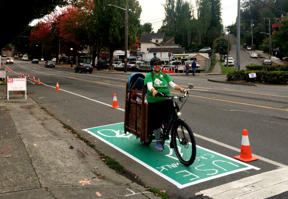
That’s why, even though this project is very exciting, it is in no way an alternative to safe and inviting bike lanes on Rainier Ave. Rainier follows a direct geographic valley through SE Seattle, making it by far the best and really only option for an easy, high quality bike route. That’s why residents like the folks at Rainier Valley Greenways are working so hard to push for protected bike lanes on Rainier, even going as far as installing several blocks of temporary bike lanes on the street last week for Park(ing) Day.

Neighborhood Greenways and protected bike lanes are not an either/or situation. We need both because they serve different functions. They complement each other, but too often people latch onto one at the expense of the other. It’s convenient politically, for example, to support neighborhood greenways as a way to avoid standing up for a needed-but-controversial bike lane.
But let’s take the planned neighborhood greenway for what it is: A way for people to get around safer and easier within their neighborhoods. I’m sure many people will use it as a through-route, but its best function will be for the people who live, work, play and go to school in Rainier Valley neighborhoods.
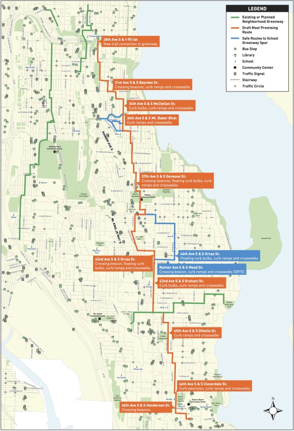
In fact, the whole plan is centered around schools and includes thoughtful school connections to make them extra useful for kids and high schoolers. Here’s the map of the city’s current plan:

 It looks kind of crazy with all those zigzags, but most those turns are necessary if you are going to stick to residential streets, avoid hills as best as possible and connect homes, schools, parks and business districts. So wayfinding is going to be extremely important for this route, more so than any other neighborhood greenway the city has built yet. For much of this route, one mistaken block out of the way could mean a very steep climb to get back on the greenway.
That said, some of the steeper hills in the plan might be avoidable. If you have any ideas, let the city know at the meeting tonight. And, of course, let us know in the comments below. I’m especially interested in your ideas for Columbia City, which has potential to be among the busiest sections if done right. But I’m worried the hills on their routing south of Alaska Street might significantly reduce use.
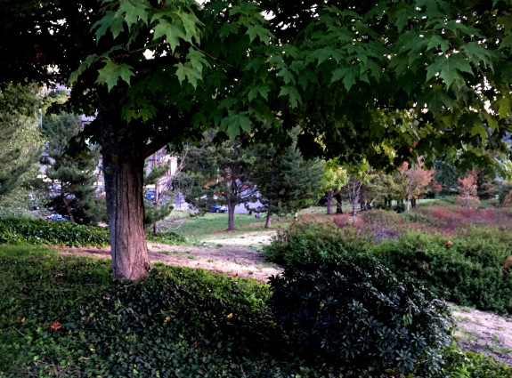
 One of the coolest ideas in the plan is the new connection to the I-90 Trail. This was one of the more difficult puzzles in the whole route. All the other connections from the trail to the planned greenway route have ridiculously steep hills. But as you can see in the photo above, people who live in the area have already found the flattest option to the trail and the nearby Route 8 bus stop. I live in the Central District and bike through this area all the time, and I never noticed this people-made path connecting from MLK/I-90 Trail to 28th Ave S.
This informal path created by so many people walking and biking through the greenspace is what urban designers call a “desire line” or “cow path.” It’s the people doing the design work for you. All you have to do is look for these paths and make them official. And that’s exactly what the city and WSDOT plan to do (the park and I-90 Trail is state property).
With a quality connection to the I-90 Trail, the Rainier Valley neighborhood greenway will connect to the Beacon Hill and Central District neighborhood greenways as well as the International District, Mercer Island and the Eastside. So finding this connection is a big deal.
Notice anything else you really like in the plan? Let us know in the comments below. And, of course, let the city know at the open house tonight or by emailing Adan Carrillo at [email protected].


Comments
18 responses to “Check out Rainier Valley north-south greenway details tonight”
Super exciting but I am guessing that you called out that downtown Columbia City section because the hill on 38th between Alaska and Angeline is NUTTY. I wish I could go to the meeting tonight!
To be clear, I did email [email protected] with my concerns/suggestions as the city site suggests!
Thanks for your excellent work on these important issues. How can we coordinate this effort with Accessible Mount Baker (SDOT) and the related plans to complete a bicycle friendly Town Center with safe east / west connections between Mount Baker Boulevard and Cheasty Boulevard? This is the original Olmsted Parkway design that is important to connnect adjacent Beacon Hill and the Mount Baker neighborhood with the new transit oriented development. Your safe routes to schools (blue lines) should also connect across the intersection of Rainier and MLK to Cheasty and Beacon Hill, where a significant number of students, pedestrians and bicyclists enter into the Town Center. Thanks!
I agree that the hill on 38th south of Alaska is best avoided. Way too steep for all ages and abilities. Better to cross Rainier on Alaska then come up through the park next to the library.
S College St between 28th and 29th is also pretty steep but probably better than any alternative residential street. Hopefully the 4 lane section of MLK will get a road diet soon to provide a flatter alternative for cyclist who don’t want to drag themselves up and over Mt Baker Ridge.
Yes. Bike lanes on MLK connecting to Mt Baker Blvd would be a great way to get from the I-90 Trail to the neighborhood greenway route. You should email that suggestion or say it at the open house.
Unfortunately, until the Accessible Mt Baker project gets going, the pinch point there at MLK/Rainier/Mt Baker Blvd is going to be difficult. But this should be part of the discussion, too.
Jonglix, that’s close to what I suggested to the contact at the city, too, except I suggested turning south at 35th Ave S. The park might be better for greenway purposes, while 35th might be better for commuter-type purposes. Great minds!
I remain skeptical about the utility of such greenways that meander through neighborhoods on local access streets. Do they get much daily ridership? enough to justify their cost? or are they there for “Sunday riders” to use for bicycling enjoyment? My sense is that far more SE Seattle riders want to be on Rainier Ave., and the money would be better spent there.
Did you read the article?
“…That’s why, even though this project is very exciting, it is in no way an alternative to safe and inviting bike lanes on Rainier Ave. Rainier follows a direct geographic valley through SE Seattle, making it by far the best and really only option for an easy, high quality bike route.”
“Neighborhood Greenways and protected bike lanes are not an either/or situation. We need both because they serve different functions. They complement each other, but too often people latch onto one at the expense of the other.”
As to the cost I would imagine this is relatively low-cost for a big improvement in safety and functionality for those who live and learn in Rainier Valley neighborhoods.
Counter data elsewhere in Seattle say neighborhood greenways have driven bigger increases in cycling than cycletracks.
http://www.seattlebikeblog.com/2014/07/23/do-neighborhood-greenways-increase-cycling-oh-yes/
Well, compare the cost of adding a few signs and diverters with the cost of a rural access road that tax payers pay for but that only serves a couple of households.
As Tom mentioned, wayfinding will be super important. I have commended SDOT in the past for their combination of signs and sharrows for wayfinding; especially at intersections. The sharrows at intersections are obvious, and point the way exactly when you’re wondering which way to go.
https://twitter.com/NEGreenways/status/519539753121640449
Let’s hope SDOT sticks with that technique. There have been some staff changes, so we may need to remind them of why it’s important.
Another example: https://twitter.com/NEGreenways/status/519540315355484160
I’m very impressed with the wayfinding on the greenway that goes from Montlake to Madison, skirting the Arboretum (not sure of its name). I remember the first time I used it, I was trepidatious because the route looked complicated. But excellent signs and street markings (and the large number of other bike riders) made it surprisingly easy to follow.
I used to ride up from Renton to the I-90 trail and this looks like a nice alternative to Rainer Ave, Seward Park, lake Washington Blvd. But I agree with the other comments, way finding on this greenway is going to be key. I often wondered if there as a lower traffic neighborhood route alternative but never explored it. Also knowing which streets dump you at the bottom of a nasty hill is also key. As my route was as flat as possible following the lake.
The only route that avoids all hills is Rainier Ave S. Other than that, there are much better alternatives to this route. This was option 3 of 3 presented over a year ago. Options 1 and 2 were both more directionally sound, and had the same number/severity of hills.
This route sacrifices everything to keep east of Rainier – it snakes all over the place, will be confusing to ride through C-City, turns away from key amenities like light rail. Poor choice. Most people going north-south will ignore it.
I live and bike in this neighborhood and have for 8 years. I bike downtown, to stores like Lowe’s or Safeway or the new PCC. This route is TERRIBLE. Truly awful. SIX 90-degree turns to go the 4 blocks of the Columbia City Business District? Who’s going to feel that’s a good, convenient riding/walking route? Coming from the south, the first turn is halfway down a hill and is more than 90 degrees. Do we imagine that people will NOT glide down a perfectly good hill onto 35th Ave S, and instead turn right-left-right-left-left-right to get as far as S Alaska? Cyclists will not use the route. Once you’re on Renton Ave, continuing to 35th Ave S, the Letitia S is the best way north. That’s what all the cyclists I see are doing, it’s already a signed bike route, and there’s zero incentive to follow this tortured route across Rainier there.
The route turns away from ~800 units of new housing in developments that have fewer parking spots than units (Mt. Zion property at ~500 units + large developments at MLK and S Alaska at ~100 units each). This is presumably a Greenway’s target audience. The route turns away from the Light Rail stop to go on a fantastic weaving journey East, then north, then back west. Then proceeds for nearly 2 miles without ever staying on one street for 3 or more blocks. People will lose the route.
When you go north 2 blocks then jog half a block west to continue north, I don’t understand how the “stop signs at all crossing streets” will work. Will there be 2 stops 1/2 block apart in order for cars to cross the greenway? Seems like a recipe for Cali-stops and accidents, not to mention frustration.
I think the deference to quiet, residential streets is too much. Make this thing a network. Walkers and bikers want to get somewhere, and this is a weak backbone for what should be a heavily used walking and biking grid in SE Seattle. I think users will see that and N-S travellers will just ignore the greenway.
One could quibble w/ the route, but the Greenway will be SE Seattle’s first north-south infrastructure.
SE Seattle is – by far – the ‘hood w/ the worst bike infrastructure in Seattle. I don’t even think that assertion is debatable… is it? Currently, SE Seattle remains completely cut off – via bike – to the jobs, cultural/sports event, city gov’t found downtown.
Here’s what SE Seattle really needs:
1. A safe & direct route connecting the Urban Villages (Rainier Beach, Othello, Columbia City, Mt. Baker).
2. A safe and direct route from Mt. Baker (Franklin HS) to Dearborn St, via Rainier, because Dearborn connects to downtown.
The Mt. Baker to Dearborn project would open biking to 75,000 SE Seattle Residents who current have virtually none. It would do more to expand biking in Seattle than any other planned project in the entire city. And it would certainly be less expensive than fixing Westlake, or the Ballard Bridge, or The Gap or Montlake.
Look at the stats – SE Seattle is the poorest, most diverse, least-well served region of the city. And so it is too with bike infrastructure. It could all be fixed with some concrete pylons and 2,000 gallons of green paint.
I’m not holding my breath.
I understand the N-S Greenway project was killed (or delayed). Is that true?
Why was it killed? Inquiring minds want to know.