Earlier this month, we reported on the city’s fantastic School Road Safety Plan, designed to help schools, parents, students and the city all work together to end traffic deaths and injuries near schools.
Well, one cool part of that plan was to improve the existing walking maps for each school and add information to help families identify a safe biking route to class. The city released those maps recently.
By marking every single sidewalk and highlighting the best crosswalks, the maps are much more useful for families trying to find the safest and easiest route for their child to bike or walk (though it would be cool to add topographic info for steep hills). The maps also include circles to help you estimate how long it will take to walk or bike to class.
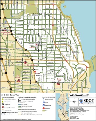
Aside from being good resources for picking a route to school, however, they are also very useful for trying to address your school’s unique transportation challenges. As the map for Orca K-8 above shows, most of the school’s walk zone (where the District does not provide buses) is within a 20–25 minute walk or 10 minute bike ride.
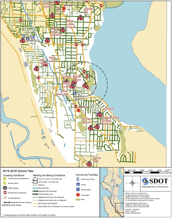
But compare that to Rainier Beach High School, where students are currently protesting the huge walk zones for middle and high schools, arguing that more (or all) students should get free ORCA passes to help them get to class. Look how far many “walk zone” homes are from the 20-minute walk circle around the high school:
 Of course, many students CAN (and do) bike or walk to school in this walk zone. And the school should absolutely do all they can to encourage more students to bike, whether that means helping students get access to a working bike, helping students acquire proper lights for dark months, offering education on how to be safe and confident in traffic, and lobbying the city for safer bike routes throughout the whole school walk zone.
But that’s not good enough. This system is not fair to students who live two miles from school and can’t afford a car or a bus pass. Showing up to school is one of the most important factors in graduation. We can’t let young people fall through the cracks just because they live in a limbo zone in their school’s transportation plan.
You can support the students in their cause by signing this petition on the Transit Riders Union’s website.
More details on the new walking and biking maps from SDOT:
Earlier this month we launched our new Safe Routes to School 5-Year Action Plan called Safe Streets, Healthy Schools and Communities to support reaching our Vision Zero goal to end traffic deaths and serious injuries by 2030.
As part of this plan, we developed new walk and bike maps for every public elementary, middle, and high school. These maps help parents and students determine the safest ways to walk and bike to school. They show crossing conditions, walking and biking conditions, and community facilities like community centers, libraries, and parks within each school’s walk zone. If you are a parent of a student at a Seattle Public School, be sure to check out these maps!
The back side of the map will guide you on how to use the map to plot the safest route from home to school. The maps display which neighborhood streets and busy, arterial streets have sidewalks and which don’t, helping you to identify a route to school that avoids busy streets without sidewalks when possible. You can also identify on the maps the safest places to cross busy streets, like adult crossing guards locations, designated school crosswalks, crosswalks with crossing beacons, all way stops, and traffic signals.
Once you’ve identified your best route, be sure to sit down with your child and go over the walking and biking safety tips included on the back side of the map. For walking, these include looking left, right, and left again at all intersections, making eye contact with people driving before crossing the street, and walking on the left side of the street far from traffic on those neighborhood streets that don’t have sidewalks. For bicycling, always wear a helmet, ride predictably and use hand signals, ride in the same direction as traffic, and walk your bike on crosswalks across busy streets.


Comments
23 responses to “Seattle releases unique walking and biking maps for each public school”
I find it interesting that 2 or more miles is a problem to these kids. If a party was 2.2 miles away…would they find a way? If a football game was 3 miles…would they find a way?
If a girl or a guy wanted to meet them whom they liked…would they find a way?
You bet they would.
I commute my kids 2.9 miles on a bike. They will be just fine.
I think you are missing the point. That’s great you can commute that far with your kids but why does the bar have to be that high for everyone? The point of the article is that it is creating one more barrier between kids and school and is proposing a way to overcome that barrier.
I’m glad your kids bike commute, good for them. Do you make sure they have a bike that fits and is well-maintained? Do they bike even if they have to stay late for a group project or a sports practice? Even if they have to carry three giant textbooks and a musical instrument? Even if it’s pouring freezing rain?
2 miles is a long way for a middle schooler, especially for those who might not have such good support at home. Why would we not want to encourage kids to get to school as much as we can? These maps are a good piece of that and ORCA cards could be too.
In briefly looking at the schools in my neighborhood it seems that SDOT forgot to add the East-West Rainier Valley Greenway that is pretty much done. I really hope that SDOT also makes it possible to provide some kind of feedback to add more traffic calming around schools, which are some of the worst places to bike or walk near during peek pick-up and drop off times.
I was surprised to not see a map for Roosevelt High School. I see other high schools (like Nathan Hale), though. Oversight?
Nathan Hale is there: http://www.seattle.gov/transportation/docs/srts/Nathan%20Hale.pdf
It is odd that Roosevelt is not on the list.
Roosevelt exists. I guessed the URL: http://www.seattle.gov/transportation/docs/srts/Roosevelt.pdf
Looks like it got left off the list. Who wants to alert SDOT?
They love hearing from me so much. I’ll do it. ;)
AWW, Andreas
I love sending SDOT my fancy emails with funny words. I did leave out the butt ugly part of the map. I am saving that for a special occasion.
opps, spelled your name wrong. Sorry about that :(
No worries, you join a very very long list of people who’ve done that. ;)
A reader on Facebook also noticed that Hamilton Middle School is missing. What else is missing?
Here’s the link to Hamilton, for the record: http://www.seattle.gov/transportation/docs/srts/Hamilton.pdf
Clearly they have something against me, since that’s my old middle and high school :p
Actually I have a funny story about that: my last two years at Roosevelt overlapped with when they were moved to Lincoln while the building was being renovated. I lived by Roosevelt a few blocks south of Ravenna (so a pretty short, direct walk to the old building) but was considered inside the walk zone, so my teachers had to pull strings to get me bus tickets (I have Asperger’s and was in the special-ed program). It amazed me that their walk zone seemed to be calculated as-the-crow-flies and ignored the big-ass freeway in the way and how hilly Wallingford in particular is, assuming it wasn’t still being calculated based on the old building.
Madison Middle School is missing. Not too hard to work out given that it’s 4 blocks east of Schmitz Park and 4 blocks southwest of West Seattle H.S.
I used some wicked cryptography skillz to crack the URL code for it though: http://www.seattle.gov/transportation/docs/srts/Madison.pdf.
It’s basically identical to the WSHS map. I like the Schmitz Park one better for its more zoomed in scale.
It’s interesting they still show Genesee Hill Elementary. I guess its replacement will be open soon enough though!
Tom, I sent Yvonee an email letting her know.
Off all the maps, that one is butt ugly. They should have narrowed it closer to the school, all that green makes it hard to read.
All of this is nonsense without overlays of the school attendance boundaries. I live two blocks from a elementary school for my kindergartner but we are out of the boundary, so I ride him 1.5 miles in the opposite direction to school each day.
That’s a good point.
School attendance boundaries are a whole other monster, influenced by politics and affecting property values. They sadly often have little to do with walkability.
I’m pretty concerned about this too, although I know there’s been a lot of drama around redrawing the boundaries. My neighbors across the street go to Green Lake, but my kid will be going to Wedgwood (ES). Routes to both are hilly, but at least GL is a gentle slope. Wedgwood is a steep drop and then a steep rise. It would be nice if school boundaries took into account topography, as a means of encouraging active transportation.
I’m wondering how a 2 mile radius is supposed to translate to a 20-25 minute walk. Tom mentions that the no-bus service area applies to those living within a 2 mile radius. However, the diagrams in the two maps above show areas which appear to be much smaller than that. The rings do look like they are reasonable close to 10 or 20 minute walk, respectively for both maps.
Where does the 2 mile radius apply? For a 2 mile radius, those the furthest out would need to walk diagonally, meaning zig-zag, for a total of about 3.5 miles each way. At 20 minutes per mile, which is fairly brisk, that’s over an hour each way.
While I totally support encouraging walking or biking to school and making it safe, expecting kids to spend an hour each way is not reasonable in my opinion. What am I missing from this story?
The white area on the map is the walk zone. The circles are just estimates of how long the trip will take you.
So the far reaches of the white area are far beyond the 20 minute walk circle. And that’s the point the students and the Transit Riders Union are making.
Example: Graham Hill Elementary School is in the walk zone for Rainier Beach HS, but it is 1.8 miles or 40 minutes away according to Google’s walking directions: https://www.google.com/maps/dir/Rainier+Beach+High+School,+South+Seward+Park+Avenue,+Seattle,+WA/Graham+Hill+Elementary+School,+5149+S+Graham+St,+Seattle,+WA+98118,+United+States/@47.5347117,-122.2856394,14z/data=!3m1!4b1!4m14!4m13!1m5!1m1!1s0x549042735caa043f:0x57909f9002025dec!2m2!1d-122.2665942!2d47.5243327!1m5!1m1!1s0x549069f87c5f77cf:0xeced2537ddc53818!2m2!1d-122.2681809!2d47.545871!3e2
Oh, I see. Thanks. So, at least they have taken diagonals and topography into account. Still, on the outskirts I can see a walk talking at least 45 minutes. I support students and transit riders union and signed their petition.