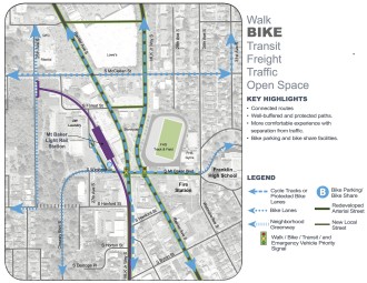
Seattle’s plan to turn one of its worst intersections into one of its best just keeps getting better. With the misleadingly-boring name “Accessible Mount Baker,” the project would simultaneously revolutionize non-motorized transportation in the whole Rainier Valley, prevent dozens of serious traffic injuries every year, improve general traffic flow, improve transit connections and create space for a successful neighborhood center complete with more housing, more businesses and more gathering spaces.
When you add up all the benefits, the $20-24 million price tag starts to sound like a real bargain.
Then general plan hasn’t changed since our previous report, but the design concept has gotten more specific and complex traffic analyses have shown the concept can work as predicted. Also, voters passed Move Seattle, which will invest $6 million into the project.
The general idea is to uncross a crisscrossing intersection of Southeast Seattle’s two major north-south streets: Rainier Ave and MLK Jr Way. Today, this intersection works horribly for everyone. The traffic volumes, turning movements and large size of the intersection require long signal cycles. Buses full of people wait, people walking wait, people driving wait and people biking, well, they’re basically left to fend for themselves.
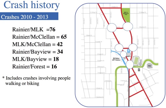
Collisions are common both at the intersection itself and at nearby intersections that are impacted by the cascading traffic headache caused by this one mega-intersection:
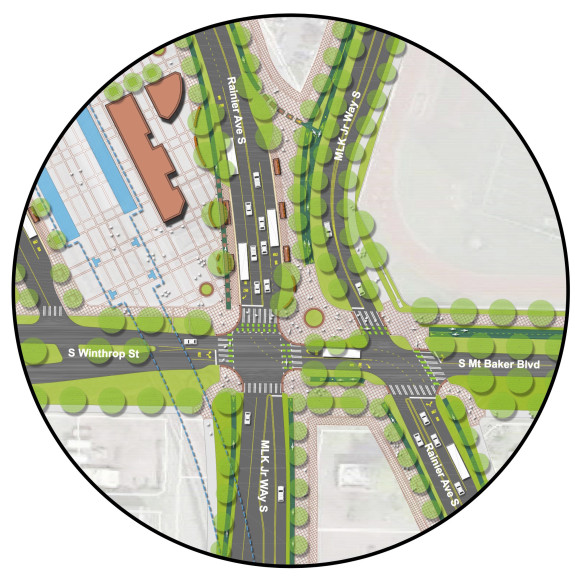
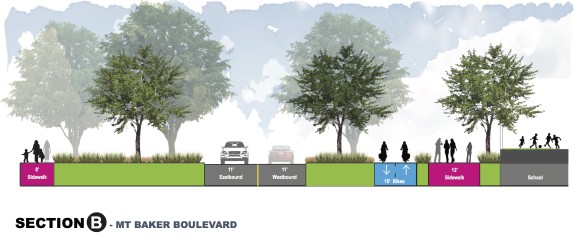
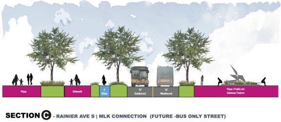
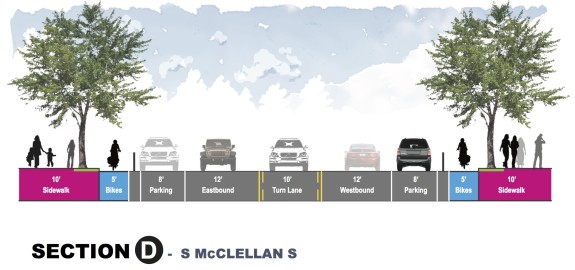
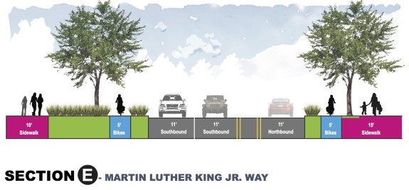
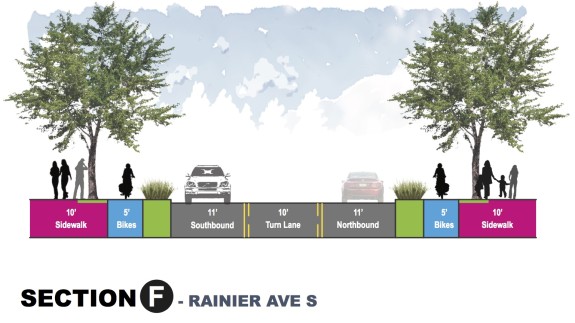
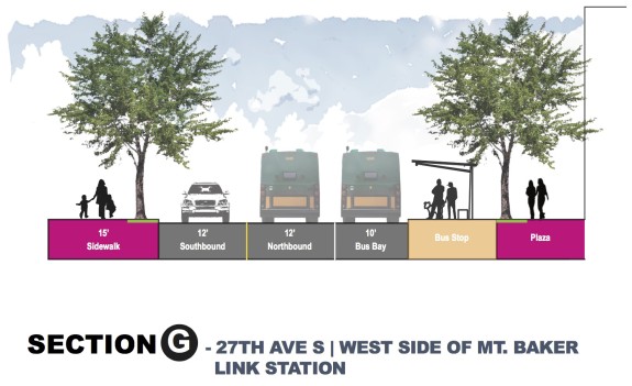
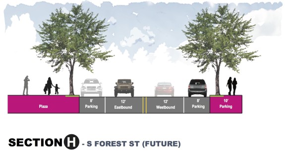
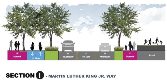
 By un-crossing the intersection, all streets flow better, allowing for more human-scaled streets complete with wider walking spaces and protected bike lanes on both MLK and Rainier. It also allows for many more direct walking connections and restores the historic Olmsted boulevard connection between Mt Baker and Cheasty Boulevards.
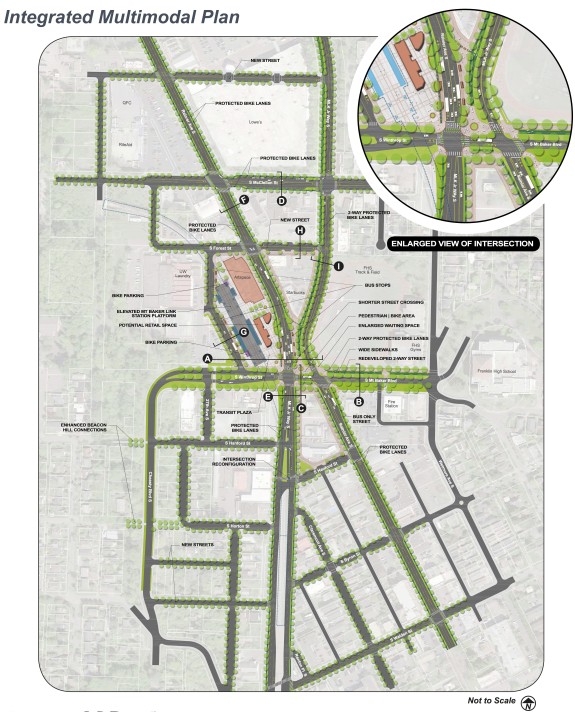
As for the bike connections, plans show bike lanes pretty much everywhere they need to be. That’s great news, setting up a major link in the biggest non-downtown bike route gap in the city. The city already plans to study multimodal improvements to the north end of Rainier Ave, and the city should prioritize building protected bike lanes between Mt Baker and Jackson Street.
There’s some work to do to on a few details, but they are basically just nitpicks this early in such an impressive concept vision. Five-foot lanes are the absolute bare minimum for bike lanes. Where possible, the city should boost them to seven feet or more, which is wide enough for people to ride side-by-side and talk or pass. And we should decide whether we want a two-way bikeway on MLK north of Mt Baker or two one-way lanes on either side of the street.
Here’s how the idea is evolving (remember that this is a concept only):
A new standard for public engagement
Another interesting note about this project has nothing to do with the design at all: The multilingual outreach process is setting a new standard for transportation projects in diverse neighborhoods. Not only did the open house include live-translation tables (something, surprisingly, I don’t think I’ve ever seen at an SDOT open house before), but the team also spent significant effort reaching out to populations less likely to show up to the department’s typical open houses.
The project’s “Inclusive Outreach and Public Engagement” process included extensive door-to-door business outreach and presentations to neighborhood groups. But it also utilized Public Outreach and Engagement Liason resources in the city’s Department of Neighborhoods to reach three three targeted groups: Youth, East African language speakers, and East and Southeast Asian language speakers. The results of these efforts are outlined and compiled in this PDF report.
The report also suggests that Seattle’s biking efforts may not be reaching these three populations well, either. If the small focus groups are representative of each population, rates of biking and interest in bike lanes are lower than the general feedback received. Rainier Valley Greenways has worked to get some materials translated, but it’s a lot of work (and pricey) to fully integrate multilingual efforts into advocacy work. As the safe streets movement grows, this work only gets more important.




Comments
40 responses to “Mt Baker intersection plan continues to wow + A new standard for public outreach”
I’m very excited about this plan. My vote is for one way bikeways on each side of the road. I think we’ve seen in the past two years that the two way bikeways just don’t work very well.
It really depends on the street/road and the specific destinations in the neighborhood.
For Seattle, we have a lot of wide arterials. In the Netherlands, the latest design for wide arterial roads with a lot of destinations on both sides is to include bi-directional cycle tracks on both sides of the road. The older designs typically have single-direction cycle tracks on each side of an arterial road. In those situations, it is common for people to treat them as bi-directional when they are reaching their destination or departing from their starting point. It’s only logical to save time and avoid crossing arterial roads unnecessarily. So, you don’t want to ever see a 5 foot cycle track. It’s simply going to happen, you have to plan for it.
Huge improvements, but planning appears to assume the changes won’t attract many people riding bikes — 10-foot, 2-way cycletracks shown in Sections A and B are only safe up to 150 bikes per hour, both directions combined, according to CROW.
5-foot one-way lanes are too narrow to be rated, but even a 6.5-foot one-way path is only good up to 150 bikes per hour according to CROW.
It would really be a shame to see so much money spent building something we know is substandard and can’t handle the sort of bicycle volumes we should reasonably expect if we make these streets feel safe.
What is this CROW thing? Google tells me its the Dutch street design manual. Is there something more relevant or controlling here? 150 bikes per hour seems like a really low number. So low, in fact, that I’m skeptical.
I have a degree of confidence that Seattle is getting this stuff more right than not these days. I know others disagree, but this seems reminiscent of the comments condemning the Westlake design.
As you say, CROW is the Dutch street design manual and is the gold standard for bicycle infrastructure standards. It has evolved thanks to decades of trial and error in developing tested standards for safe and convenient bicycle infrastructure. We should be basing our designs off of it so that we don’t have to go through four decades of trial and error ourselves, however that still appears to not be the case.
On our shores the best guide out there is the MassDOT Separated Bike Lane Planning and Design Guide, which itself took many lessons from the Dutch CROW guide. The MassDOT guide as well has a recommended width for a one-way path of <150 riders/hour as 6.5'. For a connection of this importance, at a minimum SDOT should be looking to the 150-750 riders/hour recommended width of 8.0', preferably more. See section 3.3.2.
As someone who has experienced proper and well-designed bicycle infrastructure in countries where mass cycling with riders of all ages is the norm, I have yet to see a single instance in the city of SDOT getting it right. I’ve been watching them make imitations of good infrastructure, but they still continue to make fundamental mistakes with every new project I see them build.
Yes, this design and Westlake actually do share many substandard specifications, contrary to the 2014 BMP Update which supposedly required that SDOT bicycle facilities meet or exceed both standards and guidance at the local, state, and national level.
Brian, if you want to borrow a copy, just message me.
I have the English translation.
e-mail: [email protected] with CROW or Seattle Bike Blog in the title
Two and a half bikes per minute. A bike every 20 seconds. I guess bikes have an extra special following rule? Forget two seconds, dude, I’m counting to TWENTY!
This plan will succeed in eliminating the only continuous city street from South Seattle to the downtown area. Goodbye Rainier Avenue! It seems like this report is more about the diversity of human inputs rather than a discussion of the practicality of the output. Given that the consensus of respondents said that they wanted to slow down cars- this would work to the extent that car traffic will be at at a standstill as everyone tries to navigate the new bow-tie intersection. It’s too bad the original Mt. Baker light rail station design didn’t create a bold, above street-level plaza with options for exiting and entering from more locations. The new stations at Captiol Hill and Stadium completely re-visioned pathways, while this idea falls flat because of an initial lack of forethought in the Mt. Baker station design. Similarly the Beacon station was unsafe for pedestrians from the get-go as you can only exit and enter from the West side. I might be in the minority of bike-commuters who believe there shouldn’t be a bike lane on Rainier, just in order to preserve our singular car arterial.
The singular street is still there, it’s just called MLK south of the bowtie.You have to get down to Rainier beach before it’s more than a 4-6 block gap between MLK and Rainier. People will need to readjust their mental maps to do that jog, but I don’t think it’s insurmountable.
This plan is not the bow-tie; this is the un-tie.
There are two principal arterials in the SE–MLK and Rainier. MLK has a higher capacity than Rainier, is currently underutilized per its potential capacity, and despite its faults has a safer design than Rainier. This new design will nudge more drivers on to MLK, which is a desired outcome.
Will it? That is, will it nudge more riders onto MLK? If you’re going to Seward Park or Columbia City I’m pretty sure you’ll stay on Rainier.
I really don’t know enough about the traffic patterns in that area. However, I too am wondering if Rainier should have been kept continuous and instead do some adjusting to MLK. For example, have it terminate a block early on each side of the X and make drivers travel on Rainier.
I’m skeptical that a solution based on MLK’s capacity makes sense. Just because MLK has more capacity doesn’t mean that people will want to use it.
Another possibility would be to put in a large round-about. However, I don’t think those are particularly bike friendly either because they create a lot of right-hook situations.
Nonsense. Read the paragraphs again and this time try to remember the first few. The author has done a marvelous job of explaining why this is better for everyone. The roads were built back when there were very few people using them, and traffic really wasn’t much of an issue. That has changed. It is crazy to have two very similar streets cross without separating more than a handful blocks. Meanwhile, those two streets carry the bulk of traffic (of course they do). The current system is nuts because it takes the two streets that are largely just moving people north-south, and makes them wait for each other.
This just really isn’t done much in most cities. There are exceptions, and all predate the automobile. Most are in old cities where the streets don’t even line up in a grid. An exception is Washington D. C., which has streets like this all over the place. They don’t have a rectangular grid, they have a hexagonal grid that must be a fantasy come true for you. Now you can go from the northeast to the southwest! Fantastic. Guess what — it has some of the worst traffic imaginable as a result (for the number of cars).
This gets the street grid to be more like a rectangular street grid. This is good. Improvements in safety (for bikers and pedestrians) is just a bonus. But they wouldn’t be easy without fixing the mess that was made when people didn’t have a clue about traffic science.
Drivers on Rainier have shown a persistent and damaging inability to use that road responsibly. We kill people, injure people, damage property, and generally cause a ruckus far in excess of the norm on that street.
We have 2 major, 4 lane arterials in SE Seattle that are NEVER MORE THAN 6 BLOCKS APART for almost 5 miles. And in that configuration, MLK is vastly under-used. We act like we need both when someone suggests we take one away. But the usage shows the opposite. Also, recent trips/day on Rainier are actually FLAT OR DOWN for most of the N-S run, and average VMT traveled in the city by folks who live here is in a long term down-trend.
We don’t need 8 lanes of asphalt to get us from ‘Beach to Mt. Baker. We’ll need it less in 10 years.
>If you’re going to Seward Park or Columbia City I’m pretty sure you’ll stay on Rainier.
Perhaps. In that case the people wanting to go to Seward Park/Columbia City would be able to choose from multiple connecting streets to move over to the SE portion of Rainier, instead of now where everyone gets funneled through a single choke point. On an average weekday Rainier at Rainier/MLK sees about 32,500 vehicles/day, and MLK sees about 21900. How many of those trips have Columbia City or Seward Park as their origination or destination? I’d be willing to bet that a significant majority of those drivers are through traffic, many of which are on their way to/from I-90.
I spoke with some of the planners and engineers who have been working on this, and they said they modeled something like 15 or so different reconfigurations of the area, and this un-tie came out on top. I’m highly skeptical of most US engineers building safe and high-quality walking and biking infrastructure, but if there’s one thing they do well it’s finding efficient ways to move cars.
>Another possibility would be to put in a large round-about.
I discussed this with them as well, and the sharp angle that MLK and Rainier intersect at precludes building a roundabout without some really major construction and land acquisition. The geometry of the intersection works very poorly for a potential roundabout.
Adam, you make some excellent points. One I’m not sure about though is the efficiency of moving cars. The Mercer street redo is a good case in point. The westbound travel time did get significantly better. However eastbound is many times worse, taking 10-15 minutes to cross under Aurora between 4-7pm. Yes, really!
I realize that these are complicated problems and there probably is no solution that is significantly better than the others. I hope they are right with the “un-tie” proposal.
I don’t care whether or not they’re “right” about moving cars.
Even in close-to-ideal conditions (electric cars running on a fairly clean energy mix) mass daily driving isn’t sustainable vis-a-vis climate change. If our civilization does not address climate change it has no future. We don’t need to plan for a future that is no future — and therefore a mass-daily-driving future is not one worth an ounce of consideration or planning.
(So, if SDOT said, “Our models show the new Mercer works fine,” and in fact the new Mercer is an improvement for everything except moving tons of cars toward I-5, I don’t care at all that they were wrong about that. In fact, if they intentionally did something misleading to avoid being pressured to accommodate more cars I wouldn’t care. I’d consider it a victory.)
The thought of drivers down here in the South End trying to navigate a roundabout safely, slowly, and courteously gives me nightmares. Thank goodness it won’t be put in.
I don’t see any mention of the ped bridge in the picture. I assume (and hope) that it stays. Crossing Ranier, then MLK at the crosswalks would likely require waiting for two cycles (if it’s timed for cars to not have to wait twice, then that probably means that, if you’re on foot, the second light turns red right when you get there.)
If would even better, of course, if the bridge could be rebuilt to connect directly to the platform level of the Link Station so that light rail users wouldn’t need to go up, down, and up again.
That’s a great point. Even more so since there’s Franklin HS on the other side and this would tie into the safe-route-to-school program.
There is a note on one of the diagrams that mentions the bridge being removed. It’s very non-ADA compliant and probably has other code issues. I’d be happy to see it go given the very short crossing distances proposed at grade.
While it may be a geometrically short distance, I suspect it won’t be all that short temporally.
Still, the existing overpass is surprisingly non-ADA, I crossed it for the first (and only) time on that last bicycle Sunday (pushing my big cargo bike) and was amazed. But for, say, an able bodied high school student it is probably better than a several minutes waiting for the light cycle Heck, for even for a guy that was attending Franklin when Gerald (Right turn on red) Ford was president, pushing a cargo bike, it was still better than waiting for the lights. However, since drivers never, ever, fail to stop first before turning right on a red, and never ignore “no turn on red”, I’m sure the grade level option will be perfectly safe, even if time consuming.
If the light is timed for cars to get through both Ranier and MLK in one go, that means, for pedestrians, once the first light turns green, the second light will turn red as soon as you get there, since all the cars waiting for the first light have already gotten through. (Ok, maybe if you take off running the instant the first light turns green, you can just barely squeeze through the second one, but is that really the way we want this thing to work?).
I don’t buy the argument that we need to remove a perfectly functional bridge, simply because it’s not ADA-compliant. ADA simply says you can’t build a new bridge that’s not compliant; it does not mandate the mass demolition of every non-compliant structure that was already built before the law was passed. If it serves a functional purpose for the vast majority of the population, it should remain.
In some cases, not all, ADA compliance extends to upgrading existing facilities when a threshold of other upgrades is hit — for example, if you rebuild a street that has existing non-ADA curb ramps, you actually do have to replace them with ADA-compliant ramps.
It’s possible the same issue applies here — they can leave the non-ADA footbridge as long as the rest of the intersection stays the same, but if they upgrade a substantial part of it, they have to bring the rest of it into compliance.
Regarding the demolition of that existing non-ADA foot-bridge; why can’t we have a bold, expensive plan with lovely ramps that cross over the roads to the light rail station? Those wacky high school students can catch the train without jaywalking, and all those silly commuters could get from the bus/transfer station like magic! Be bold, let’s take the Starbucks by eminent domain and make something beautiful! Perhaps the problem is that this plan doesn’t go far enough to really do something that benefits everyone who uses this area every day. We’ve poured billions into Mercer and the new stop at the UW-Stadium. Let’s demand more in South Seattle for this intersection!
The Rainier-MLK intersection is among the worst for peds-bikes in the city. Cars win too because the Untie eliminates of that long light intersection. It creates a heavy flow traffic on the south route and calms the north route, which makes sense (even though I personally live closer to MLK).
For walking/biking – the plans are great to get through the area. One will be able to walk between Light Rail Station, bus terminal and Franklin HS. So local plans – great.
However, there are no current plans to tie bike lanes into the larger SE Seattle community.
— No N-S link to move between the urban villages (R-Beach, Othello, C-City, Mt-B), though the N-S Greenway will help if it’s ever built.
— And, of course, SDOT has no near-term plans to link Mt-B with Dearborn/Jackson to connect SE Seattle w/ city center.
This is classic Seattle DOT in SE Seattle. Build a nice, east-west bike lane that starts somewhere promising and ends nowhere anybody needs to be- like piers into the ocean.
– from R-Beach light rail to Lake Washington via Henderson
– from Beacon Hill to Alaska/Rainier via Columbia
– from Rainier Ave to L. Washington via Genesee
So the Mt B intersection is great. But SDOT needs to focus on the bike infrastructure SE Seattle really needs: North-South and connections w/ downtown.
There are protected bike lanes planned north from the intersection on both MLK and (crucially) Rainier… it’s just not clear how far they’re supposed to go. Of course Rainier is the flattest route by far, and anything that goes up to the I-90 trail is significantly hillier, but…
– The Rainier lanes don’t have to get much past Bayview to connect to 25th Ave, and taking that to I-90 isn’t too steep, right? Maybe there’s a jog to 24th that’s better, I’m not totally sure. In this case I bet SDOT could be convinced to do a bike project on these streets if enough people made the case for it.
– If I recall correctly, to have a not-too-steep route to I-90 west of Rainier, the Rainier lanes would have to make it as far as Hill Street. But then you have to climb up to the intersection with 12th and take that toward downtown… the 12th-King route could use some work that’s certainly outside the scope of this project. Anyway, if they planned improvements as far north as Hill Street they’d probably have included a diagram of Rainier/23rd, so I’m not too hopeful for this.
– If the Rainier lanes get close to I-90, people might fill in the gap on the sidewalk of Rainier. To avoid the worst ramp crossings riders would stay on the west side south of Massachusetts and cross over to the east side north of it, and use Hiawatha to connect to I-90.
– If the MLK two-way path makes it to I-90, taking that to I-90 wouldn’t be too bad. It has some blocks that are a bit steep, IIRC.
None of these routes would be ideal, but I think any would be an improvement over current ones, opened up by the possibility of using Rainier to bypass some, if not all, the hills.
Ah, that was a brain-fart at the end of the paragraph about the Rainier sidewalk route. They’d used Hiawatha to connect to Dearborn, not I-90.
With all due respect, Al:
The routes you suggest send bikers up a 250ft hill (to South First Hill) or up Beacon Hill. Those are fine for fit, aggressive bikers like myself, but they are huge impediments for new bikers or anybody towing a kid. The routes are complex (how many turns do you need to get up to Sam Smith Park from Rainier/MLK?) and in many places, unsafe.
And those routes are unnecessary because Rainier Ave is
flat, straight and direct. Any rider could ride from Rainier/MLK to Dearborn in 4 min if a safe bike lane existed on N Rainier – it’s 1.5 mile long and completely flat. Plus the street is 120 feet wide, plenty of room for a bike lane.
SE Seattle is the only neighborhood in the entire city without a reasonably safe, direct and as-flat-as-possible route downtown. N Rainier Ave the the only possible route that doesn’t crest a giant hill.
SE Seattle also lacks any usable N-S bike infrastructure connecting the Urban Villages of Rainier Beach, Othello, Graham, Hillman City, Columbia City and Mt Baker.
While Seattle has vastly improved bike infrastructure all over the city, SE SEattle has been systematically ignored. We’ve got no political juice, we have no angry rich housewives banging the drum at community meetings.
Seattle DOT and the Mayor have their bread buttered elsewhere – they have proven that they don’t give a damn about SE Seattle’s bike infrastructure needs.
Not that any of you should give a damn.
[…] Mt. Baker: Seattle Bike Blog shares concept plans for a revised and safer street network near Mt. Baker […]
[…] The Rainier/MLK Bowtie: A bit south of Columbia City. Proposed redesign for the complicated intersection near Franklin High School and the Mount Baker Light Rail Station. Here’s the Seattle Bike Blog’s review of the plan. […]
If your goal is to further the time spent in traffic, increase accidents and driver frustration then this is a brilliant plan.
I cannot imagine how reduced traffic lanes, increased bike traffic and a double intersection to replace the existing single intersection will do anything other than snarl the already horrible traffic on this route.
If you need to use the existing route to travel to your job, then by all means, you’d better contact your city officials and let them know this plan WILL NOT CUT IT
I take it you didn’t go to the meeting. The presenter at the beginning did a fantastic job explaining how this will work and why the single mega-intersection is causing the traffic problems. I wish there were video of his talk. I’ll ask around.
“building protected bike lanes between Mt Baker and Jackson Street” !!! Yay! May it be so, and soon!
John Anderson, I do in fact use Rainier Ave to travel to my job, by bicycle, with 3 children along whom I escort to their pre and elementary schools. I use Rainier Ave to get to my child’s speech therapy at Hawthorne Elementary, to shop at Mutual Seafoods, Bartells, QFC, Lowes, PCC, u haul propane, to get to the fabulous Rainier Beach CC swimming pool for family swim, to visit yummy taco trucks. I am so excited that a few of the many hazards my family faces in our daily rides to employment, school, therapy, sustenance, and play will be reduced by these improvements.
I think the reduced number of lanes on Rainier – since this is going to be a road diet, reducing both NB and SB car lanes by 50% – is really going to mess with traffic during rush hour. Back-ups of NB traffic trying to get onto I-90 in the morning and huge snarls SB in the afternoons will clog Rainier and these newly configured intersections, slowing cars and buses significantly during peak hours. It’s going to be rough for commuters and buses.
Tom,
I hope you are able to get the traffic simulation and post it here at some point.
Even, better the presentation by Ian Lockwood was very compelling. It gave a clear case for how this works for all modes of transportation, especially CARS.
Out of all the meetings that I have been to regarding transpiration changes this was well attended by a diverse population. MJ did a great job putting several components together. This was not just the SDOT show, it showed real community. What worked to their advantage were the current changes to Rainier Ave. A lot of data and outreach was done.
Little things they did mattered so more people could be there: interpreters, babysitting, food, dedicated SDOT people at situated stations, the streaming traffic video of the intersection, and open engagement from SDOT.
I am glad this moving ahead and look forward to the next phase
[…] latest iteration of the plan for the Mount Baker station area. It all looks great except there is too much plaza space. More buildings […]
This plan gets better and better, but does not address the name confusion as the routes switch. I would suggest the north section of Rainier Ave from Mt.Baker north to Jackson be renamed to Boren Ave, in essence extending Boren Ave. Either part of M.L.K. could be renamed, and by the time the project is complete a great candidate for a name would be Barack Obama Way!
[…] out of Bruce Harrell’s office is to provide funding ($2 million) so that the widely acclaimed Accessible Mt Baker project can be ready to apply for major federal grants. Accessible Mt. Baker provides a major […]