The team putting together a plan for a new arena directly south of Safeco Field plans to build a new pedestrian bridge over the train tracks on S Holgate Street as part of a multi-million dollar public benefits package to pay the city for Occidental Ave, which lies in the path of the proposed arena footprint.
This project has sparked controversy for some (especially freight companies) and hope for others (especially for those who want an NBA team in town). But for the sake of this blog, we are only going to be looking at the impacts and proposed public benefits that affect biking and safe streets. Ultimately, I’m pretty sure the project will live or die based on other factors, but I’ll leave that story to other reporters.
One of the major hurdles for project approval is the “street vacation” of Occidental Ave, since that requires City Council approval. That’s why the Seattle Arena team is headed to the City Council Sustainability and Transportation Committee tomorrow (Tuesday) during their 2 p.m. meeting.
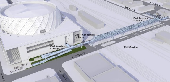
Proposed Holgate Bridge
 The proposed pedestrian bridge is billed as a biking and walking facility, but as shown in a presentation to the committee it is really more of a walking facility with tight switchback ramps at both ends that add significant distance to the journey. The west end of the bridge will provide direct arena access, and the east end of the bridge will drop people at the Sodo Trail about a half mile south of Stadium Station.
People biking would likely use the bridge when trains are blocking Holgate, but that’s really it. At other times, biking up and down the ramps adds significant distance and climbing when you can just bike two blocks over the tracks. Using the bridge will be even less appealing before and after games when the bridge is crowded with people walking.
Now, if there were a complete and direct trail connection to the Mountains to Sound Trail that didn’t include tight switchbacks, that could be an incredible addition to the regional bike network and provide great arena access from Beacon Hill, the International District, the Central District and the Eastside.
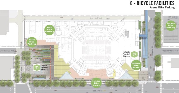
Bike parking and valet

In addition to the new bridge, the project list also includes a bike valet, several bike parking areas and new Pronto bike share stations.
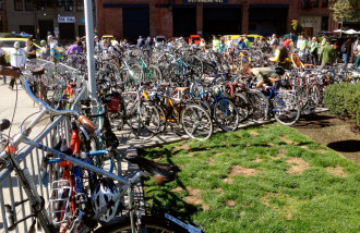
I would hope they are planning for way more bike parking than is currently available at Century Link and Safeco Fields. Sounders games bring a huge number of bikes, and the temporary bike racks outside the stadium are consistently filled to the brim. The bike cage in the Safeco garage is rarely full, though I suspect most people don’t know where it is or how to get there. Which brings us to our next point…
1st Ave needs protected bike lanes
 Because of a previous Occidental Ave street vacation for Safeco Field, 1st Ave S is the only street that directly connects from Pioneer Square to both the south side of Safeco Field (including the bike cage in the parking garage) and the proposed arena. As noted in the arena’s environmental impact statement, “A majority of the bicycle traffic was concentrated along 1st Avenue S. where there are sharrows or shared lanes.”
If people are choosing to bike on an extremely wide and busy street that only has some painted sharrows, it’s pretty clear that 1st Ave is the only viable route option, at least from the north. If there were a better street, people would use it. But there isn’t.
Occidental is currently a low-traffic route for people headed to Safeco Field from the south, so vacating Occidental for the new arena will have a direct negative impact on bike access to Safeco and the Edgar Martinez Drive bridge. And the only option that will adequately mitigate this loss is to build protected bike lanes on 1st Ave S.
The Bike Master Plan was created before this arena plan was released, so it’s appropriate to take another look at its suggested routes in light of this new major development. The first draft of the Bike Master Plan included protected bike lanes on 1st Ave S, and I strongly supported them at that time. When they were cut from later drafts and the final plan, I argued:
Sodo’s most glaring change compared to the first draft of the plan is deletion of 1st Ave S. This is a huge mistake and missed opportunity. 1st Ave S is incredibly wide, and it would really not be difficult or intrusive to freight to build a safe bike facility there. It connects to a ton of jobs and destinations even without the planned arena south of Safeco Field.
Even industry spokespeople know that 1st Ave is dangerous and uncomfortable. In this 2013 bulletin from the Manufacturing Industry Council, Executive Director Dave Gering talks about how his foot was run over on the sidewalk of 1st Ave while giving an interview about Sodo traffic and the proposed arena. He also spoke about a series of tragic biking and walking deaths and serious injuries, including the death of Lance David on E Marginal Way:
… SODO is also full of human beings. The recent tragedies show the multi-modal traffic hazards are painfully real. SODO needs far more effective measures and programs to accommodate the area’s growing, unique and hazardous mix of cars, pedestrians, bicycles, trucks and trains.
Knowing that most people on bikes are going to want to access the new arena using 1st Ave — and knowing also that the sidewalks are not wide enough to accommodate biking and walking before and after games — building protected bike lanes on 1st Ave S is the only option that makes sense for bike access.
But beyond arena and stadium access, protected bike lanes are also the best way to separate the many modes trying to get around safely and efficiently in Sodo. Biking in “shared lanes” on a busy street like 1st Ave S is not a comfortable experience, but neither is driving a large truck in shared lanes with people biking.
1st Ave connects downtown to a huge number of jobs in Sodo and to neighborhoods like Georgetown and South Park. Neither the Alaskan Way Trail nor E Marginal Way has easy access to large sections of 1st Ave, so they can’t be considered alternatives even though they look nearby on a map.
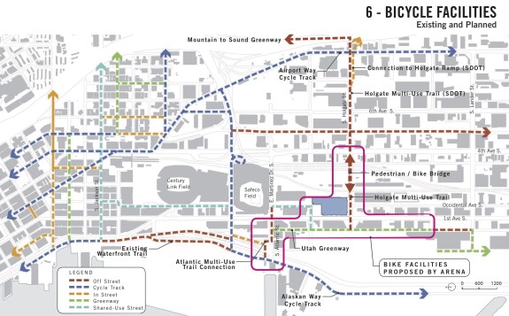
The arena plans include a neighborhood greenway on Utah Ave S, an already low-traffic access road west of 1st Ave. Well, low traffic except for game days when people are trying to score a deal on parking. Today, Utah does not have direct access to Pioneer Square, so it’s not an alternative to 1st Ave S bike lanes.
The arena plans call for a new trail link to the Alaskan Way Trail, somehow traveling across the Hwy 99 tunnel’s south portal (if the tunnel is ever finished, of course). This connection could be great, but there are a whole lot of “ifs.” And even if it were complete, it’s still not as direct as 1st Ave S. It should be considered in addition to bike lanes, not as an alternative.
Here’s the list of bike facilities the city currently plans to require as a condition of the Occidental Ave vacation:
- Complete public bicycle facilities from existing waterfront trail to arena site to Starbucks
- Improvements implement the Bicycle Master Plan
- Improve Atlantic Street multi-use trail (600 l.f.)
- Complete and repave Utah Avenue Neighborhood Greenway from S. Atlantic St. to S. Stacy (2,800 l.f.)
- Complete S. Massachusetts multi-use trail (175 l.f.)
- Complete S. Holgate St. multi-use trail (160 l.f.)
- Bicycle wayfinding signage (12+ signs)
- Bicycle signal at S. Atlantic St. Crossing to Waterfront Trail
Most funds go to cars and trucks
Finally, a note about funding. Though the pedestrian bridge carries a hefty $15 – $18 million price tag, it’s nothing compared to the investments in cars and trucks. The arena project would spend $45 – $65 million on a new parking garage and contribute a yet-to-be-determined amount to the $140 million Lander Street Overpass project.
If we’re going to build this arena, let’s make sure bike access is done right. If it’s comfortable and direct enough, a big chunk of fans will be able to get there by bike just like they do to Sounders games. And better yet, Sodo will be a safer place to work and play.


Comments
17 responses to “Arena plan would build pedestrian bridge for Holgate, needs bike lanes on 1st Ave”
Jaysus Christ Tom, they’ve already ruined 2nd Ave with the PBL and now they wish to ruin 1st? before you think I’m a crackpot, I’m a subscriber, that introduced myself to you at ECR.
SDOT’s recent work on the 2nd Ave cycletrack recognizes that the sidepath is too narrow and congested for the speeds many average riders travel in the city.
It’s time for SDOT to take a page from the Dutch National Cyclists Union and actively encourage faster riders to ride in the street where they’re safer. (See http://www.fietsberaad.nl/?section=nieuws&lang=en&mode=newsArticle&repository=Fast+bicycles+on+the+roadway for a short summary from CROW.)
The travel lanes on 2nd Ave remain open to bikes, but too many drivers believe people on bikes must use bike lanes or sidepaths, without considering whether the path is safe or goes where the rider needs to go. (See, for example, https://www.youtube.com/watch?v=u_K0GYGkbJU on 2nd Ave.)
Whenever constructing a separated facility beside a street, SDOT should spend a little bit extra on paint and signs to remind all road users that riders are free to choose the safety of the street over the separation of the path.
Shared lane markings, properly centered in a travel lane, accompanied by Bicycles May Use Full Lane signs, would not in any way restrict use of the separated facilities by those who prefer them, but should reduce harassment of riders who find the sidepath unsafe or poorly-connected to their destination.
I LOVE the 2nd PBL. We ride it all the time to get to Seattle Center, solo, with children attached, with children on own bikes, with elderly aunts. Sure, continuous improvement, it could be tweaked, but if you want more than 0.05% of the population riding bikes, the infrastructure needs to make that possible, and PBLs are a HUGE part of that. If you want to ride around town with my children and elderly relatives and see what the PBLs make possible, let me know.
I’m skeptical of the benefits of a 1st avenue lane with SoDo Trail just a few blocks away. Given the choice between riding the trail or 1st ave, there’s no way the one with giant freight trucks and stoplights every 50 yards wins.
I have to ride on 1st ave Monday through Friday, as its the only way for me to get to work. As it is, I have to conquer train tracks, dodge semi-trucks, and half-awake drivers just to get from the Elliot Bay Trail to 1st. And I’m far from the only one who has to take this route. While I could theoretically take the trail to my work, inevitably I’ll be put on 1st, and the trail would add an extra 15 min to my commute. I’m already waking at 5am so that is just not happening. As it is, I only feel safe on my commute on the Trail and the 2nd ave bikeway, so any additional bikeways aren’t just welcome, they are appreciate, and longed for with a craving stronger than my want of sugar.
Holgate and Utah are key elements here. The Holgate bridge should connect directly to the Mountains to Sound trail without switchbacks. It is not so much a way to get to the proposed arena. It’s a way to fulfill a long desired connection to Beacon Hill.
the trail up above this is actually the “mountains to Beacon Hill trail”. If done right, this would connect Beacon Hill and the Central Area, International District and south Seattle to SODO, the SODO light rail station, West Seattle and the central waterfront to finally make a real Mountains to Sound Trail. This should be seen as a couplet with the Lander St Overpass, which will serve primarily freight traffic, but also some heavy bike commute locations including SODO light rail station, Seattle School District central offices and Starbucks HQ. The Holgate bridge also allows vacation of the surface street at Holgate, which will allow Amtrak to unify and secure their rail yard, which is presently split by Holgate. PBL’s on First are going to be token, given the number of driveways. But the Holgate Bridge could be a big win.
West Seattle Bike Connections submitted comments at each stage of the EIS process asking for this and other bike route mitigation for the impact of the arena project. Extracting funding from the arena project is the least they can do, and this plan is a starting point for discussions on how best to use it.
I should have been clear, I’m not against the Utah greenway. I’m just against it as an alternative to 1st Ave S.
And the Holgate pedestrian bridge doesn’t look like it will connect to the MTS Trail, unless you know more than I do. The Bridge over I-5 has a tiny sidewalk that ends in stairs.
As proposed in this rendering, the Holgate bridge would not connect up to the MTS trail. I’m saying it should.
Tom, can you clarify what you mean by “multi-use trail” proposed for S Atlantic, S Holgate and S Massachusetts?
It sounds suspiciously like a ploy to dump bikes on sidewalks and label them “multi-use trails” as if the designation suddenly improves things.
I’m hoping you can show me I’m completely mistaken and it’s really a fantastic new facility and I should stop being so cynical.
That’s the city’s language.
Good point Joseph – you can see an example of this underneath the Spokane Street Viaduct: I remember talking to planners as that was being constructed, and they paid lip-service to it being a bike route. What we got is a wide-ish sidewalk, punctuated by unmarked curb cuts and the occasional concrete pillar, with a potential two-block connection to the SODO trail completely ignored.
“Though the pedestrian bridge carries a hefty $15 – $18 million price tag,”
Between this and the Northgate bike/ped bridge we really need a better explanation from the city on why these bridges are costing taxpayers almost double what they cost to build in other countries, and the rest of the United States. Bridges in Europe built by internationally acclaimed architects that are longer (and much better looking) are being built for $8-$10 million in developed countries like Germany, Denmark, and the UK where labor and materials are more expensive.
$15 t0 $18M for a bridge over a block-wide rail yard is not out of line. The S Lander Street overpass is estimated at $145M in the city’s current federal grant application, and they are not trying to make it expensive, they are trying to make it competitive with other grant applications.
I’ve heard a rumor that the City wants to close Holgate St. between Occidental and 3rd Ave. S. This new overpass would allow a ped and bicycle connection in that corridor, in spite of the street closure.
If Utah is taken seriously as a neighborhood greenway car access would essentially have to be banned around event times.
My guess is that the plan is not at all serious about Utah as a greenway, that it will be overwhelmed with cars during events, during rush-hour, and any time people want to park there for any reason. And that’s a shame. The SODO Trail is fine for going through (once it’s actually connected to stuff), but for local access to businesses clustered along 1st, including cafes, bars, and restaurants with their high bike-commuting rates, a good route on or right next to 1st is needed.
I hope the surface level sidewalk would remain open. A two block long seperated facility is too creepy for walking alone.
Note that I encourage comment on this as to making it contingent on it being possible to ride a bike to an event there. The NFL and MLS groups have adopted restrictions on bags which will make riding to any event impractical. You can only bring a clear plastic, vinyl or PVC and does not exceed 12″ x 6″ x 12.” The bags can have no strap and you can’t even take in a case for eye glasses/sunglasses. While this new arena would be indoors which will make the clothing while attending the event less of an issue do not expect to have the ability to bring a rain coat, a bike pump or even a patch kit in a bag.