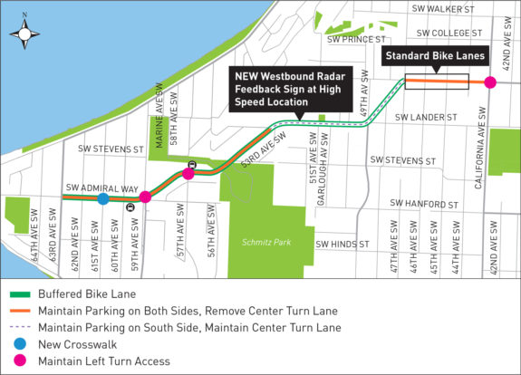
 After more than a year of public outreach and significant design changes, SDOT is just about ready to paint bike lanes on SW Admiral Way from Alki to (almost) California Ave SW.
The official painting schedule is not yet out, but work should be completed before October, according to the project website.
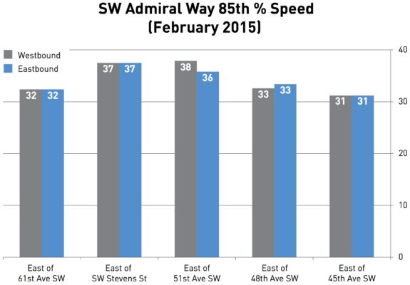
While the bike lane connection will be a huge boost for the West Seattle bike network, the biggest beneficiaries of the project will be people in cars and people who park along the street. Speeding is rampant in large part due to wide travel lanes, and there are a lot of collisions every year:
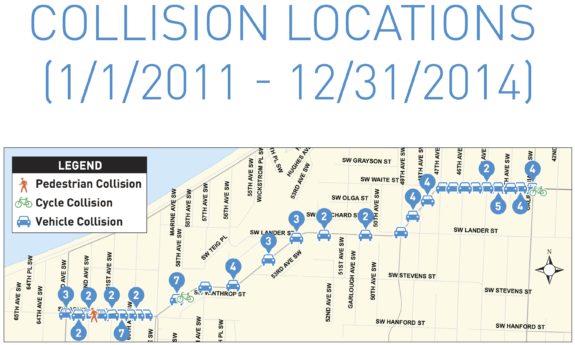
 “There are lots of crashes on this street caused by speeding drivers losing control on the curves,” said Admiral neighbor and West Seattle Bike Connections advocate Don Brubeck. “My next door neighbor’s parked car was hit and exploded one night the year before last. My van was hit while parked. A guy up the street had someone plow into his company van and pushed that one into two other parked vehicles.”
According to Brubeck, even flashing warning lights haven’t slowed people on the curves. As someone who bikes, he is excited about the bike lanes, but as a neighbor he also hopes the narrower lanes will help reduce speeds to people stop crashing.
After all, damage to some parked cars is far from the worst that can happen when people lose control of their cars in a neighborhood.
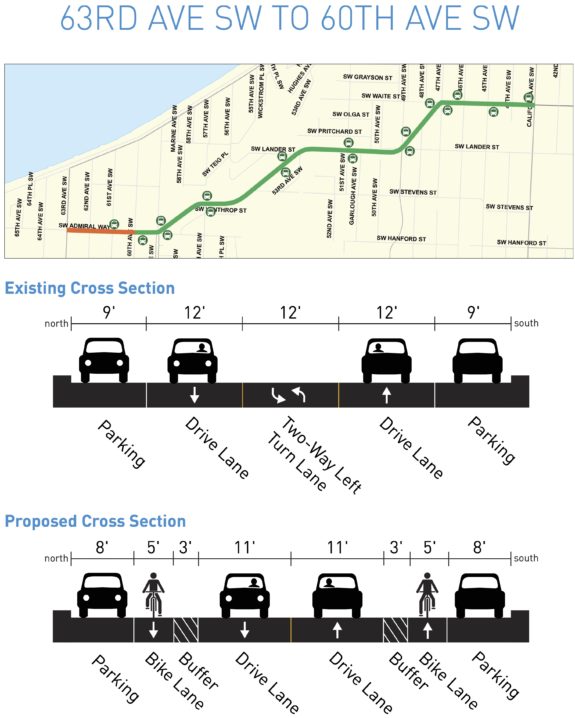
The bike lanes will have buffers for most of the project length, and the city is experimenting with the buffer location. On flat and uphill sections, the buffer will be between the bike lane and general traffic. But on downhill sections next to parked cars, the buffer will be next to the parked cars to give space for opening car doors (a danger that increases the faster the person biking is moving).
Protected bike lanes were not considered because there are so many driveways along this residential street. The city needs to figure out how to create safe protected bike lanes on streets with driveways, but such designs would likely involve raised driveway crossings (which adds cost) and/or restricting parking far in advance of every driveway to improve visibility.
The worst part is that the bike lanes turn into skinny, paint-only door zone bike lanes at the top of the hill that then disappear entirely for the last block before California. So it’s yet another bike project that leaves a key connection incomplete.
For a low-budget road safety project, this will certainly be a big improvement. But it does fall short of the “all-ages-and-abilities” standard the city should be striving for.
Here’s a section-by-section look at the plans:
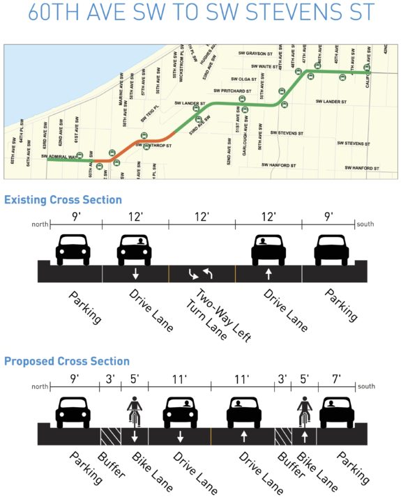
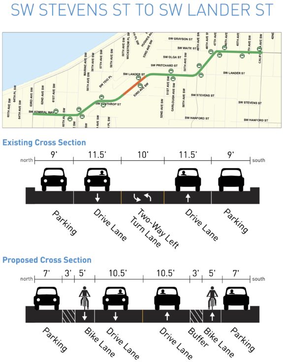
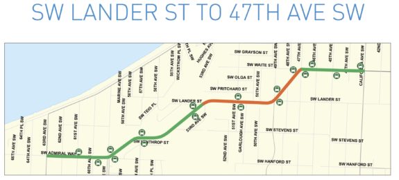
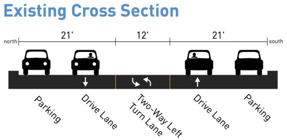
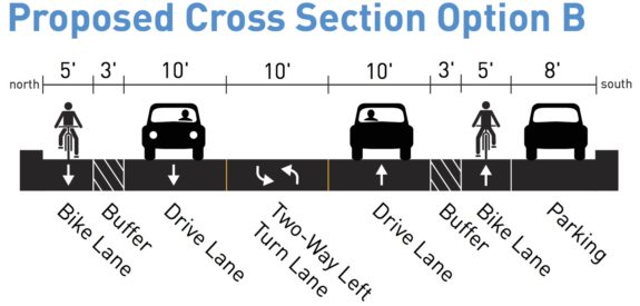
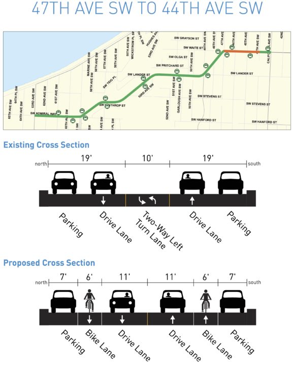
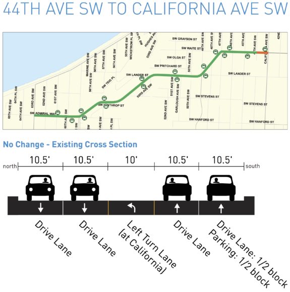 West Seattle Blog recently posted this project update email from SDOT:
We’ve spent the last few months incorporating feedback into a street design that will reduce speeding and crashes and preserve parking where it’s in high demand.
We heard during public engagement that people are driving too fast along SW Admiral Way, crashing into parked cars, and residents are afraid to cross the street. In fact, one mother choked up at our first public meeting at the thought of walking her children across SW Admiral Way.
When we started the project data showed there had been 71 vehicle crashes, two bike crashes and one pedestrian crash between 2011 and 2014. From January 2015 through May 2016 an additional 34 crashes have occurred. This statistic shows that crashes along Admiral Way SW have increased by nearly 28% in the past 1 ½ years. The neighborhood has people who’ve lived here for decades, new families, and visitors enjoying Alki Beach. Each person deserves safe travel whether walking, biking or driving.
After sharing a few designs with the neighborhood, studying on-street parking occupancy during the summer, and talking with community members, (the map above shows) what will be installed.
You may be wondering how the new design improves safety. We have proven success throughout the city that narrower travel lanes reduce the speeds people drive and the number of crashes.
We are also adding buffered bike lanes. Adding buffered bike lanes makes the street operate more predictably by giving everyone a space; and makes biking more comfortable, which can encourage more people to give it a try.
Here is how your input was included:
· Parking study. We conducted an on-street parking study during the month of August. Study times were 5-7AM, 1-3PM and 5-7PM on a sunny Saturday and Tuesday. The study confirmed what you told us. Parking spaces on the west end of the street with convenient access to Alki Beach are in high demand.
· Center turn lane. At our first public (meeting) you suggested we remove the center turn lane rather than impact on-street parking, so we did in the high-demand parking area.
· Left turn access at 57th and 59th Avenues SW. At the second public meeting, you requested left turn access to help reduce the risk of being rear-ended. We’ve included the access. To make room for them, about nine on-street parking spaces will be removed on the south side.
· Crosswalk at 61st Ave SW. We asked if you would like a new crosswalk in this location and one is included in the project.
Here is what we were not able to include and why:
· All-way stop at 59th Ave SW. You suggested we change the pedestrian activated signal at this location to an all-way stop. Unfortunately, studies showed that an all-way stop at this location did not meet guidelines. However, we have agreed to look at it again in the future.
Finally, we heard you want improved pedestrian crossings and supplied information on where. We’ll conduct a second round of outreach on August 20 in the form of “Walk and Talks” to gather site-specific input and talk about low-cost opportunities (visit web site for more details). The Walk and Talks will build off of comments collected through the first phase of outreach. Any improvements identified would be installed as a second phase of construction.
Our project web site at seattle.gov/transportation/swadmiralwaysafetyproject.htm has information on the walk and talk; and a flier with similar information will be mailed early August. Construction information will be shared as soon as available. However, work to restripe the street is expected to be completed before October 2016.


Comments
15 responses to “SW Admiral Way bike lanes ready for summer construction”
Any indication what material will be used for striping the left-side buffer for the door zone bike lanes?
If you’ve ever seen a dooring happen in real life, even 10 mph is too fast to safely ride in the door zone of parked cars. It’s an invitation to a nasty crash.
If the buffer striping is just paint, concerned riders can simply avoid the hazard of the marked bike lane and ride in the buffer zone to avoid dooring. But if the buffer striping is thick thermoplastic, it makes for a very unpleasant riding surface, forcing people on bikes to choose between the comfort of the bike lane or the safety of the travel lane.
I know I’d choose the travel lane — I’m not fast by any means, but I’m old enough that things break when I fall; no paint on earth is going to get me to ride in the door zone.
Totally agree. Further, some of the parking lane widths are marked as 7′ with an adjacent bike lane.
Enough cars are 7′ wide that, allowing for door width, one needs to cycle with the handle bars at least 10′ from the curb. That puts the other side of the handle bars at 12 or 13′ out – 15′ out if a delivery truck is parked in that zone. The traffic lane is 15′ out. So the result is a anywhere from a 0′ to 2′ buffer from the traffic lane. Is this safer than current?
NCHRP 766, “Recommended Bicycle Lane Widths for Various Roadway Characteristics,” published by the Transportation Research Board, actually says the door zone width of standard passenger vehicles reaches 11 feet from the curb, not just 10 feet, and that infrastructure should keep bikes out of that zone.
http://www.trb.org/Main/Blurbs/171010.aspx
Does anybody know if California has any plans for becoming a better biking street? Right now it is a “sharrow” street for almost its entire length. The configuration is one lane each way, with one lane of parking on each side, with a center turn lane.
West Seattle does not seem to have any plans for, much less any existing north/south protected cycling infrastructure. California seems like the most natural fit, since it levels out most of the hills on the adjoining streets.
Or am I supposed to believe that our never-happening-because-NIMBY “Greenways” are the alternative to a protected bike lane?
California Ave SW is fortunate, for much of its length between the Admiral and Morgan junctions, to have calm, relatively flat streets either immediately east (42nd Ave SW) or immediately west (44th Ave SW). These are close enough to the commercial district along California to still be convenient, but with much less traffic. West Seattle Bike Connections has been advocating for these routes to be improved as greenways since we were founded by Don in 2013,
The proposed bike lanes on Admiral Way will definitely encourage more people to use their bikes for transportation. The Alki commercial district has no major retail destinations. For groceries, pharmacy, mailing dispatch, pet store, bank, library, doctors, dentists, etc., we must climb the hill. Hopefully fewer people will choose their fuel burning car to make this trip if Admiral Way is made more welcoming to cyclists.
I wouldn’t go so far as to call that “fortunate”.. Greenways are fine for covering ground between destinations but when I’m shunted off to a side street so I’m not “in the way” on roads like California, full of shops and restaurants, I’m certainly not going to be stopping to spend my money at merchants on the “car road”. Additionally, California is such a busy space with many uncontrolled marked crosswalks that there is no reason not to slow motor traffic and better accommodate bicycle traffic from Admiral to Fauntleroy.
I’m not sure I understand why WSBC wouldn’t advocate for something significantly more valuable to cyclists: protected bike lanes on an important travel corridor: California Ave..
I understand that this is politically difficult and many people’s feelings would be hurt and they would be very sad about ceding some land to bikes, but it’s obviously the right thing to do for California.
We can hem and haw about Greenways the rest of our lives, and even then they won’t provide the same speed, ease of use and access that protected bikeways would serve. You can even look at the hard data: California was leveled out to provide fewer ups and downs for street cars, while the adjacent 44th and 42nd have plenty of inclines and declines, some of them fairly steep and abrupt, almost all of them at intersections. Additionally, 44th and 42nd have major interruptions that require detours, like around the West Seattle High School, Lafayette Elementary, as well as Erskine Way and Ferry Ave.
It is time for West Seattle cyclists to GO BIG with their hopes. California is the best-suited street for cyclists for a West Seattle North South route. It is already a through route and has controlled stops for all cross traffic. It is level and does not require confusing detours. Greenways are a weak, ineffective half-measure.
I sincerely hope that the WSBC will begin advocating strongly for its repurposing as a cycling thoroughfare. Can anybody from WSBC explain why the organization would not want protected bike lanes on California? I’m genuinely curious.
Why would we not advocate for PBL’s on California? Because riding on 44th, 45th, 42nd, and Walnut between Admiral and Alaska, and on 42nd south of Alaska is so easy and actually faster than on California without the stoplights and construction zones, and there are short, obvious and easy connections over to California from them. Really look at how narrow California is, and all the bus stops, and how tough it would be to put in PBL’s that actually offered protection from something. And, more importantly, we have higher priority streets for PBL’s. We need them on the busier angled arterials that mount the ridges at decent grades, like Avalon and Fauntleroy, and we need PBL’s with concrete barriers on East Marginal Way, and we need something on or parallel to Highland Park Way, where speed differentials and traffic volumes are greater. And we need the flyover ramp at the Chelan 5-way intersection. Those are big. California is not “going big”. It would be diverting resources away from big things.
If we can’t get rid of parking to allow for 24/7 bus lanes on streets like 15th Ave and Aurora, do you think we’ll be able to get rid of parking of California for PBLs?
Jortsy and Que, if you feel strongly you want to place your energy on convincing Junction merchants to give up street parking in favor of protected bike lanes, I say more power to you. In fact, you have an opportunity this Parking Day Plus (September 16 and 17) to get the City to ban parking and create a temporary bike lane. Here’s the application (not sure if the deadline is past, but it is worth a shot): http://www.seattle.gov/transportation/docs/PARK(ing)_Day_Application_FINAL.pdf
If anyone has details on the Seattle-specific issues around protected bike lanes and driveways, I’d be interested. I’ve seen articles like this that suggest they’re not incompatible: https://bicycledutch.wordpress.com/2011/08/18/but-we-have-driveways/
In particular that article specifically says driveway crossings are not raised. That article is from 2011, so maybe that’s not the current state-of-the-art?
I used to live in the Admiral district and that hill was a regular bike commute route for me. I do understand the high speeds that are possible on the downhill have to be taken into account. Still, my reason for racing down was mostly a desire to match the possible speed of cars as I was hanging out in the lane to avoid doors and it was usually terrifying (though the views are fantastic). Nowadays I spend most of my time in protected lanes and I’m plenty happy cruising along at a much slower speed. My understanding is slower speeds are a common response to better infrastructure. Also the uphill is quite long and steep, so the speed would generally be far less in that direction without any special treatments.
As a kid I did get my leg broken in a driveway-related collision (riding on the sidewalk), but that didn’t necessarily give me insight into what the best practices are, or what research or demonstration projects are needed. Or is this just another “we can’t have nice things because we have hills and driveways” excuse?
The driveway crossings are raised in that example (relative to the road). So someone tuning into a driveway needs to go up a curb to cross the bike lane.
[…] bike lanes: SW Admiral Way in West Seattle is set for construction of new bike lanes this […]
Amusingly, this project was, until a week ago, brought to you by Bridging the Gap funding, and is now being brought to you by the Let’s Move Seattle pile of money with a suggestive list of projects.
So, there, tada, more bike projects in the Move Seattle levy happening right now… pay no attention to any cutbacks elsewhere.
https://web.archive.org/web/20160713023501/http://www.seattle.gov/transportation/SWAdmiralWaySafetyProject.htm
What I’m talking about.
http://westseattleblog.com/2016/08/traffictransit-today-monday-updates-admiral-way-closure/
Clear daylight, dry, morning commute. Car driver out of control crashes into utility pole on a curve this week, shuts down the road for hours.