It is 2016. Nearly every month this year reached the hottest global average on record. Cities across the world and across our nation are working to remove downtown highways that divide and depress their vital economic and cultural centers.
Yet Seattle of all places is still preparing to build a new surface highway between the glorious Elliott Bay waterfront and its downtown core despite warnings from major transportation advocacy groups warning that such a wide roadway would put people walking in danger and would make the city’s waterfront less desirable and accessible for yet another generation. On top of that, the groups pointed out that the wide planned road would induce more motor vehicle trips and increase the release of greenhouse gasses, directly in conflict with the city’s stated greenhouse gas emission goals.
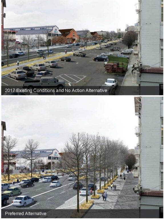
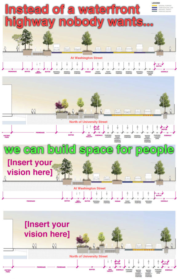
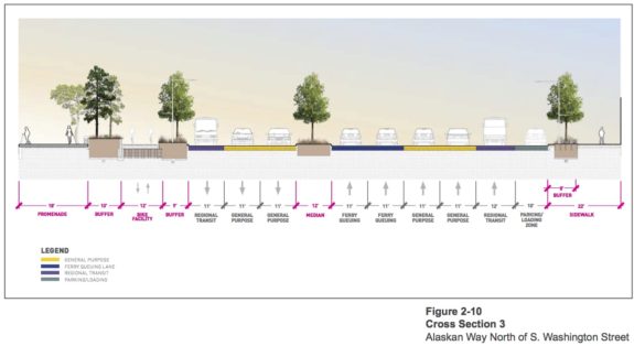
Waterfront Seattle, lead by Seattle along with regional and state partners, released its final environmental impact study Monday, and it shows that planners chose to completely ignore the advice of these groups. Their vision for Seattle’s waterfront “boulevard” remains the same as before: Up to 37 yards of motor vehicle traffic separating our historic downtown from the waterfront:
It would take as long as 30 seconds for a fit and able-bodied person to walk from curb-to-curb between Pioneer Square and the new waterfront promenade. For our slower-moving neighbors — including many kids, seniors and people with mobility challenges — the walk may take so long that they will only be able to make it to a mid-street island before the light changes. They will then need to wait in the middle of this highway for a second round of traffic to go by before continuing their journey to the waterfront.
This is a slap in the face to these neighbors. It is an institutionalized insult that tells people walking on the waterfront (or to the ferry terminal) that they are not important or valued, especially if they are not physically able to race fast enough to beat the signal countdown.
This plan is wildly counter to the vision most people want from their revamped waterfront, I’m pretty sure. The multi-billion-dollar tunnel highway was supposed to allow us to reclaim our waterfront. Instead, we’re also getting a highway on top of our tunnel highway. If this surface highway plan is constructed, our future waterfront will be less accessible from most of downtown than it is today with the loud, shaky and unsightly Viaduct.
We cannot let this happen. The environmental review and design process has gone horribly wrong, blinded by a windshield perspective that has led planners to miss the big picture: The Viaduct removal project is about reclaiming our waterfront. It is not about filling our waterfront with cars.
The easiest way to fix the plan should have been the design process itself. But stern-yet-polite comments from respected transportation advocacy groups like Feet First, Transportation Choices Coalition and Cascade Bicycle Club were not heeded (see their letter and Waterfront Seattle’s dismissive response). All these reasonable suggestions were rejected due to concerns the “level of service” for motor vehicles would be worse than Waterfront Seattle’s preferred plan.
But Waterfront Seattle is not equally concerned about the “level of service” for people walking. If they were, the proposed street would look very different. And that’s the problem at the heart of this project: The core framework put cars first, then asked the people what they wanted to do with whatever was leftover. They never truly questioned whether 37 yards of traffic is too many.
Likewise, the environmental study ironically includes page upon page of traffic projection analysis but only one page out of 328 mentions climate change (you know, the environment). That page notes:
“it is difficult to isolate and understand the GHG emission impacts for a particular transportation project. Furthermore, there is currently no scientific methodology for attributing specific climatological changes to a particular transportation project’s emissions. Therefore, impacts from GHGs at the project level are generally assessed in a qualitative manner.”
Translated from planner speak, this means that they know how to measure traffic, but they don’t know how to measure greenhouse gas emissions caused by their projects. So they chose to ignore the need to reduce emissions rather than concern themselves with understanding the impact more car trips (and fewer walking trips) would have on greenhouse gas emissions.
But while the planners aren’t concerned about climate change, the people of Seattle and the Puget Sound Region sure as hell are.
The environmental study also makes no mention of environmental justice concerns, like disproportionately poor air quality in lower-income neighborhoods along SR 99 south of this connected project area.
So now our city, state and regional leaders really only have one option: Reject this highway plan and demand a better waterfront boulevard that respects every resident of our city, including those walking and those with mobility challenges. And demand a project that takes climate change and the city’s stated goals of reducing the share of downtown trips taken by motor vehicles seriously.
The good news is that other than the surface highway itself, most of the plans are great. The overlook walk to the market is very exciting, as are many of the ideas for the new public space on the waterfront. So we don’t need to go all the way back to square one. We just need to redo the highway section.
A sea of traffic in Pioneer Square, a new Mercer Street for the rest

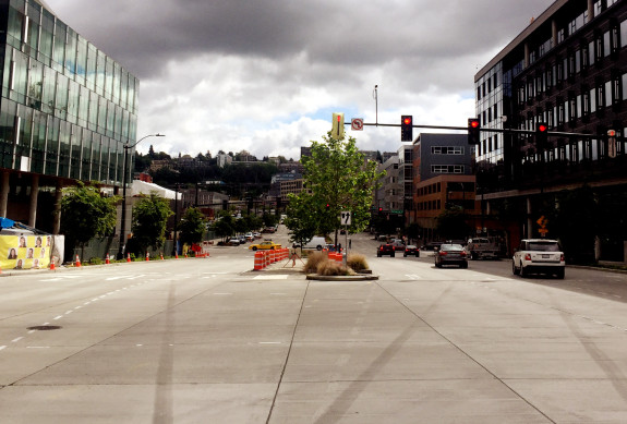
While the extremely wide 111-foot street splitting through Pioneer Square is certainly the worse part of the plan, the rest of the street is much too wide, as well. You don’t need to wait and see what this will be like, you can just go down to Mercer Street in South Lake Union today. That’s almost exactly what the city and state are proposing to build on the waterfront. It’s an uncomfortable and far-too-wide street where nobody wants to spend time and that people avoid walking across if they have a choice.
Is this really the vision for our waterfront?

Mercer is perhaps the best cautionary tale for this waterfront project. Once slated for a viaduct-style elevated highway separating the city center from Lake Union (a plan narrowly defeated), the Mercer corridor has been attempting to act like a highway for the past generation. Walking, biking and transit was an afterthought at best and actively discouraged at worse (remember how skinny the Broad and Mercer Street sidewalks were under Aurora?).
They city recently spent $237 million to remake the corridor, but they compromised in favor of moving car traffic at nearly every opportunity. The road is too wide, lanes are too wide, corners are shaved back to allow high-speed turns, and signal cycles are too long requiring long waits for the walk signal. The result is a road that works for nobody. Traffic is miserable, walking across it or along it is miserable, and it doesn’t support nearby businesses. Everyone loses.
If the Waterfront Seattle plan goes forward, the same exact thing will happen on the waterfront. But it doesn’t need to be this way.
The waterfront remake is not about cars, it’s about people
 Here are the stated “guiding principles” for the Waterfront Seattle project:
- Create a waterfront for all
- Put the shoreline and innovative, sustainable design at the forefront
- Reconnect the city to its waterfront
- Embrace and celebrate Seattle’s past, present, and future
- Improve access and mobility (for people and goods)
- Create a bold vision that is adaptable over time
- Develop consistent leadership from concept to operations
Yet the current design of the waterfront highway is directly counter to nearly all of these goals. Therefore, the result is a failure and should be rejected.
Perhaps what planners are missing is that this should be a transformational project. Instead, they are trying to accommodate their projected number of cars based on current use. But those cars are there today with a viaduct that provides people with a huge incentive to drive. We have the power to make different decisions with our new waterfront. We can build to support the uses we want.
That means providing access for motor vehicles, but not prioritizing them. Instead, make walking, biking and transit the undisputed easiest and best ways to get to the waterfront and the ferry terminal.
We are a big city with an increasingly dense center. Driving will never be easy here, and reasonable people don’t expect it to be. It’s not easy today, and it won’t be easy in 2030 or 2045 either. The harder we try to make driving easy downtown, the more harm we will do to the walking environment. And the traffic will still be there regardless.
By prioritizing this extremely valuable public space for people, we will open the waterfront up to a generation of new ideas. A wider public promenade will be able to do more than we can even imagine right now. We cannot know what a local entrepreneur, event planner or community leader will think to do in that space throughout the next generation. But it could be the next iconic, creative idea that makes Seattle Seattle. That’s the waterfront vision I believe in.
So the question is: Will any of our public leaders stand up against this surface highway? We tried the nice route, offering design suggestions and comments, but that didn’t work. Is it time to protest?


Comments
45 responses to “Seattle’s planned waterfront highway takes major step forward. It must be stopped.”
Yikes. This was certainly not the vision that was sold when the tunnel was rammed through. We were supposed to get a nice waterfront park, not an 8-lane highway.
The only way to reach a compromise is to stop suggesting compromises. We should propose what we actually want, a downtown park (which Seattle is sorely missing) and a transit-only corridor.
Yes – advocates for pedestrian-oriented development on the waterfront need to learn that negotiating against oneself by proposing a ‘reasonable compromise’ is a losing strategy. Splitting the difference between ‘OK’ and ‘Terrible’ gives you something that’s still more bad than good.
Tom, I appreciate your passion, but this is a lot of words for a sermon to the choir and lacks distinct actions that we can take to help stop this. Or, if they’re in there, they’re lost in the avalanche of words.
There is no official comment pathway anymore. This is the final version. I’m trying to sound the alarm, but there is no clear way to get engaged. That’s part of the problem.
So I see two ways forward (which could be complementary): 1) People/orgs need to create a campaign for a better waterfront boulevard and 2) We need a city leader (City Councilmember?) to get involved and lead the effort from the inside.
I’m emailing my city council members. This is not what I voted for.
Can’t some group file a lawsuit to block it? For example based on the fact the EIS didn’t address the climate impact?
We live in a twisted world. I’m not sure climate change impact is required as part of an environmental impact statement. Up is also down.
The Environmental Impact Statement is not about the impacts to the wider natural environment (what we think of as “environment”), but about the impacts to the immediate area. Environment for EIS is the environment in which the project is sited (the “human environment”), which in this case is a city. There are probably quantified impacts to water quality and air quality, but the biggest impact to the human environment is traffic, so that will likely be the focus of the EIS.
This isn’t just a waterfront problem. SDOT is still highly obsessed with Level of Service for cars. It becomes very clear when you look at some of their safety projects, sadly. Places with low traffic volumes that should become one lane in each direction are kept as two, despite being a clear danger to pedestrians (and drivers, who weave between lanes!).
Good to see Tom has a new pet project instead of his continued advocacy for a failed and failing bike share program. How is this a surprise? We knew all along WSF wanted two lanes for ferry waiting. That never changed.
WSF actually really, truely needs an overflow solution. Ever seen what happens on holidays/sunny Fridays now? (hint, the ferry line backs down Alaskan to the Aquarium). This problem will only get worse starting next year, when they are tearing down the current Pier (including parking as far as I know) and rebuilding the terminal.
That being said, there are other ways to handle that (ie, space that is otherwise parking or additonal pedestrian space that gets closed off in anticipation of busy ferry traffic). And the multi-lane highway proposed is unacceptable.
Park’em up on a southbound remnant of the viaduct, from 1st ave s to yesler.
Its not the high line, its the ferry waiting zone.
Build a bridge to colman dock. End it just before the ped bridge.
The lane configuration on the waterfront should not be surprising. The tunnel under downtown has no exits. Current viaduct connections at Elliott and Seneca and Columbia don’t exist, so most of the traffic that depends on those connections won’t be in the tunnel; it will be on surface Alaskan Way instead.
Seriously – I’m shocked that anyone is surprised by this. The viaduct may be ugly, but it does not stop anyone from getting to the waterfront, and it gets the traffic (car and some freight) away from the surface streets. Without legit grade-separated transit in this corridor, there are still going to be a LOT of cars. Not to mention all the freight. And ferry/cruise ship traffic. And periodic freight train blockages. Alaskan Way is going to be packed.
Tom wasn’t kidding when he said that we’re building another Mercer on the waterfront. The lead engineering manager on the waterfront project, Angela Brady, was also a top project manager on the Mercer project:
https://twitter.com/NEGreenways/status/793503886690529280
That’s from her LinkedIn profile.
Since we have been unwilling (as a city) to call out Mercer as the abject failure that it actually is, we’re not willing to distance ourselves from the people who created that failure. Or to put it in internet-friendly waterfront terms: All Aboard The Failboat.
After reading this article, I must say I am extremely disappointed in our Seattle leadership. I thought our city’s goal is to become a mass transit city, yet the waterfront surface highway completely neglects that goal. Why did I just vote YES on ST3 just to have another highway built? What happened to bringing the waterfront street car line back? I have the fondest memories riding the waterfront street car as a kid; talk about something that was iconic Seattle! There should be transit only lanes and two vehicle lanes. If WSF needs more waiting room; there are structures called parking garages. There will be plenty of space once that eye sore (viaduct) is torn down to build a garage for ferry overfill. I have already lost the appeal of my neighborhood (Capitol Hill) to ugly, cheaply build and over-priced apartment buildings to greedy investors and I don’t want to see our amazing waterfront move in that same direction. Let’s make the Emerald City green again with a big waterfront park, environment friendly mass transit, bike lanes and pedestrian walkways and not nasty pavement for more polluting cars downtown. Wake-up city council!!!! We don’t want another highway!
Excellent summary. No, no to shoreline traffic, it needs to be park space.
Will this have a 20 mph speed limit? How about speed bumps for the general purpose lanes? There has to be something to limit traffic or everyone will be skipping the toll tunnel for the waterfront freeway.
If it’s anything like Mercer, when traffic is light drivers will race to beat the next signal and when it’s heavy traffic will back up into the intersections blocking ferry and cross traffic.
Boy am I jaded…..
We all know it’s you “Bill N” – rescue us with science!
Sorry, not the Science guy and I don’t think science will help on this. I am spending this weekend in New Orleans. I could pick up some chicken bones or an Ed Murray voodoo doll…
who are the best folks to write letters of concern to?
Mayor?
counsel members?
somebody tell me what they think would work best. this sucks.
I just emailed council members Sally Bagshaw (district 7, downtown) and Kshama Sawant (district 3, Capitol Hill area).
[email protected]
[email protected]
Thanks for providing this information Jared. I’ll email my council woman immediately. Not sure how much it will do but I don’t know what else is possible.
Thanks Tom for raising our awareness about this horrible design. One important additional point about how it’s not only terribly unfriendly for non-motorized travel, but is going to be very unsafe as well. Such a wide boulevard is going to going to leave pedestrians out is the street exposed longer and also will encourage cars to drive faster.
The Department of Ecology’s State Environmental Policy Act guidance includes a tool to calculate greenhouse gas emissions for a project. Did SDOT just not see that?
http://www.ecy.wa.gov/programs/sea/sepa/climatechange/index.htm
I am betting (hoping) the aforementioned polite but stern commenters have lawyers looking at it. What a supremely ridiculous and insulting project. It is just bizarre how consistently the City proposes stuff completely counter to its blandishments about its own progressiveness. Utterly maddening.
There is a very interesting WA Atty General opinion from 2008 addressing whether GHGs need to be mitigated under SEPA. Opinion suggests not mandated by state law but could come into play if the agency in question (SDOT) has a GHG policy. Tried to copy and paste to no avail. If anyone’s interested:
http://www.ecy.wa.gov/programs/sea/sepa/climatechange/aGLtr.pdf
If you’re going to build a surface highway, why bother with the tunnel? This seems to make a mockery of all of the justifications for that tunnel. Unless planners, well, planned it this way: with a tunnel below and a highway above, there is a much improved Level of Service… for cars. For humans, it’s going to suck.
Dept of Ecology just lets WSDOT roll right over it. Happening right now on new 520 bridge. Bright path to nowhere lights shine into water which is extremely dangerous for small salmon who easily become prey. Also Montlake market was to stay in EIS but now isn’t and WSDOT can redesign as it goes along and Ecology is silent.
[…] Advocates have been warning against replacing the current elevated highway with a highway-like surface street. But that’s exactly what the agencies planning the future of the waterfront are poised to do, reports Tom Fucoloro at Seattle Bike Blog: […]
I think the real atrocity here is that the Missing Link is being wrongly held up in EIS hell, while the waterfront highway was pretty much greenlit and rubber stamped through.
If three companies can haphazardly sue to indefinitely delay a fully designed trail on public ROW, it seems like a well organized coalition can sue to provide interference for this monstrosity; although if the EIS is complete, I don’t know if that would accomplish anything.
Yes, a horrible design for the waterfront roadway, and since the City sold off the historic streetcars, no public transit service.
The selling off of the historic street cars, the paving of the track when it wasn’t necessary all gave us indicators of what the city had up it’s sleeve for this road.
I suspect that only a mass civil disobedience display will get anyone’s attention. Time to organize a bicycle road blockage at least long enough for the TV crews to show up and film and ask why.
Oh and as you know Richard, they closed the waterfront track so that 1st Ave would be eligible for Federal funds. (Otherwise they are too “close” together even though they are separated by at least 100ft in elevation.)
[…] multi-billion-dollar tunnel highway was supposed to allow us to reclaim our waterfront,” writes Tom Fucoloro at Seattle Bike Blog. “Instead, we’re also getting a highway on top of our tunnel highway. If this surface […]
One big difference between the waterfront “mercer mess” and the viaduct is the railroad crossing at pier 70. The viaduct and Western Ave. are east of the tracks so no crossing. The waterfront arterial will cross the tracks at grade so there will be huge backups waiting for trains (coal, oil, grain, containers, sounder, freight, amtrack, …) to clear the intersections. At least the cars will have plenty of lanes to choose from to wait out the slow moving mile long trains. Maybe they can order a pizza or Ivars fish-n-chips and have it delivered to their car.
Tom, nice spot on the morning news.
Here is a tool to find your Seattle City Council members. Email yours if you’re concerned! I agree an 8-lane highway is far too many lanes.
http://www.seattle.gov/council/meet-the-council/find-your-district-and-councilmember
[…] a crossroads: Seattle Bike Blog decries the recent Waterfront Seattle design proposal over the amount of space given over to car […]
Someone seems to have a clue here in 2016, with four lanes under the highway and a shared space for parking and pedestrians next to the water. I had expected that to be the final design, not nine lanes of traffic. Who ordered that?!
2 waiting lines for the ferry makes sense, but only if you get a ticket for idling. No idling if you’re just sitting there. I don’t want to breathe your cancer-cloud. Shut it down.
[…] the associated waterfront promenade and public open space improvements. Many urban advocates have argued against such a wide streetscape for vehicles and instead for a larger public realm dedicated to open space […]
[…] wants more surface parking, the transit community wants bus lanes, and the bike/ped community wants a more human street. We’ll write up our thoughts […]
The current proposal is insane. Waterfront should be a park for all with a small street running through it.
[…] “stroad” (surface highway) has upset a conflicting array of local advocates. Walk, bike, and Vision Zero advocates rightly clamor for a smaller, safer, slower roadway (reduce the general […]