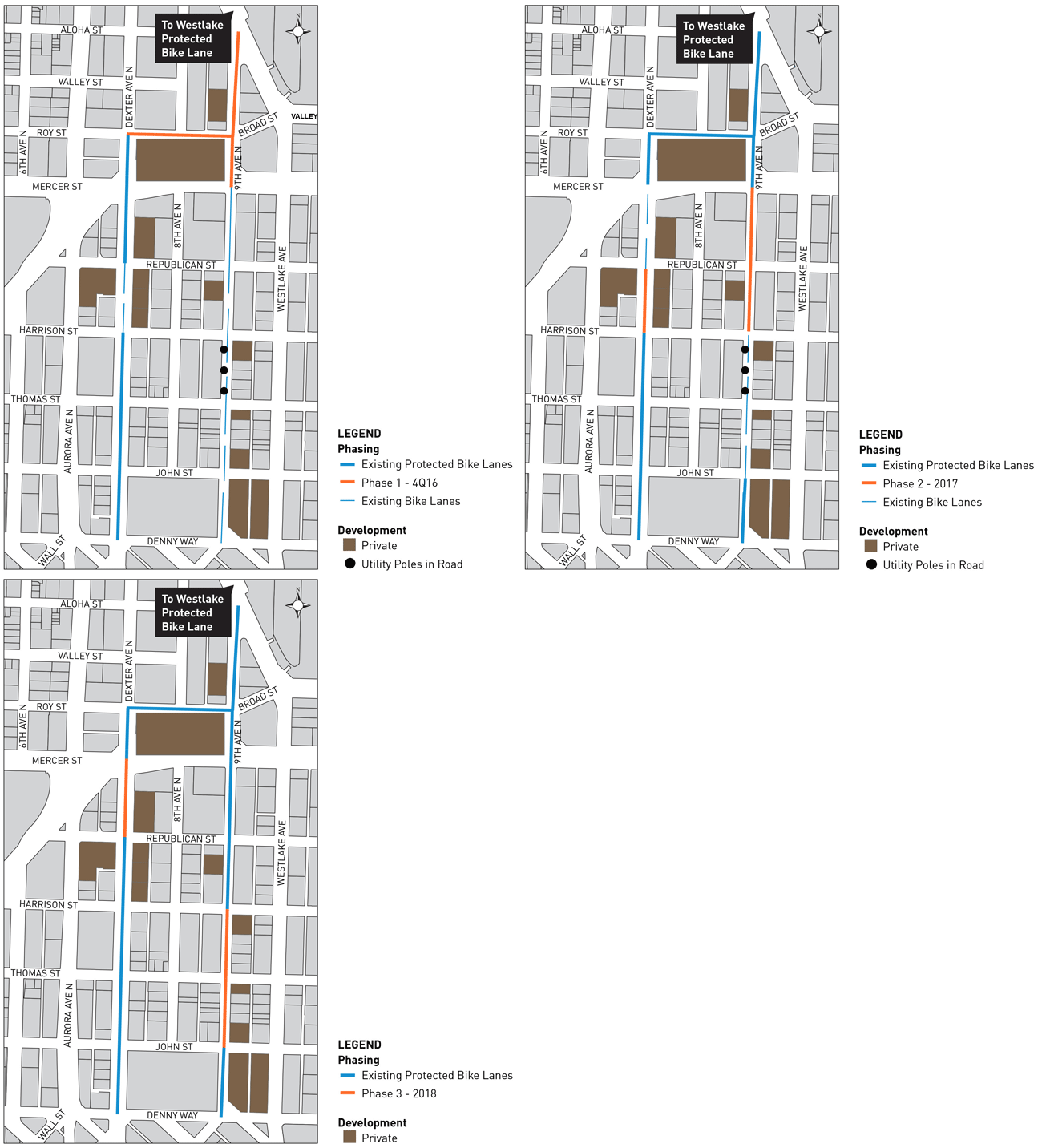
People using the Westlake Bikeway can now, finally, get to and through South Lake Union via a mostly uninterrupted route of bike lanes.
It’s not the most direct route, and the connection into downtown is still incomplete. But for an interim solution, wow, it’s a lot better. And as a video by Seattle Neighborhood Greenways’ Tim Fliss shows, the bike lanes are getting a lot of use even though they aren’t fully complete yet:
Huge amounts of development activity along the street have delayed the opening of a complete 9th Ave bike lane, which is scheduled for completion in 2018. So the city installed a new protected bike lane connection to Dexter Ave, which connects into downtown via 7th Ave.
Until now, people heading south in the Westlake Bikeway reached Lake Union Park, then were just sort of dropped from the bike network to figure out the rest on their own. For most people, this meant either mixing with backed-up traffic on 9th Ave or mixing with the bike-wheel-grabbing streetcar tracks on Westlake Ave. Both of these options were awful, effectively stranding the south end of this major new bike investment.
The new connection (which was not yet finished as of my recent visit) will guide people diagonally across the intersection at 9th and Westlake into a new protected bike lane:
This connection requires mixing with people walking on the sidewalk, which is not ideal. But at least it works.
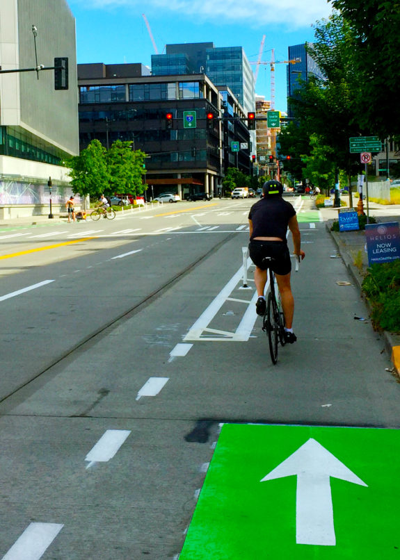 Once on 9th, people biking have a clear path to get around backed up traffic that can’t move due to backed-up traffic on Mercer Street. My photos were taken on a Sunday, so there is little traffic shown. The video above is a more typical look at the problem.
This bike lane has created a way for people to keep moving in this increasingly congested area. Spending millions on fancy traffic signals can’t fix the problem of too many people trying to drive on Mercer Street. But slapping some paint and plastic posts on the ground can create a real transportation option overnight. And it works.
The 9th Ave bike lanes continue to Mercer Street, and people who want to continue into South Lake Union via 9th Ave can do so on the existing paint-only bike lanes. But the next year or so will see a lot of bike lane closures and disruptions on 9th, so many people may want to turn right on Roy Street toward Dexter Ave instead (though Dexter will continue having its own construction disruptions).
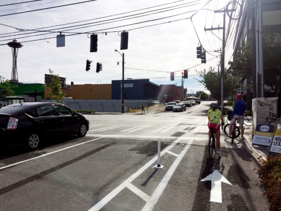 Roy now has new protected bike lanes for the short stretch to Dexter, which has also received some more plastic posts. The route from Westlake to Dexter works very well, but the left turn onto Dexter to head downtown needs some help.
Right now, people in the Roy Street bike lane are expected to wait for the green light, then cross the street and stop in a small two-stage turn box. Then when Dexter gets the green light, they can head south. The problem is that this is a major bike route, and if many people try to use this Dexter connection they simply won’t fit in the little green box. An all-way walk/bike phase would help move more people if that becomes an issue.
Many people will also continue using the sidewalk and crosswalks on Mercer to get from 9th to Dexter, which isn’t a terrible option. But until 9th Ave is complete, people are going to need to find a way to weave around or mix with traffic for stretches.
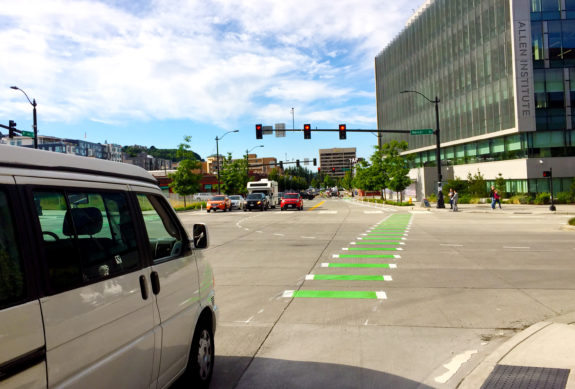 Crossing Mercer at 9th Ave remains awful, though the new protected bike lanes at least make it easier to make your way past the snarled traffic to get to the intersection. But while the green paint is clear in these photos (again, this was a Sunday), it will often be blocked by all the backed-up traffic headed to I-5. Mercer is just a miserable, car-focused street that doesn’t work for anyone. The best the city can do is to try to provide non-driving options for people to get around, and these new bike lanes are a good start.
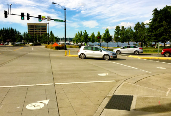 Heading north to the Westlake Bikeway, the final crossing at 9th and Westlake still needs help. The new bike lane makes it way easier to get to the signal, but an awkwardly-placed concrete island and poorly-designed signals make getting to Lake Union Park and the bikeway a bit confusing. Bike dots lead people biking to use the crosswalk, but as you can see in the photo, the walk signal does not show unless you waddle onto the sidewalk and push the beg button.
This is an obvious case for #GivePedsTheGreen. The walk signal should appear every signal cycle whether someone pushes the button or not. And it’s much easier and cheaper to simply trigger the walk signal automatically than it is to install a new button next to the bike lane. This is a major crossing between a dense neighborhood to a major park. This signal should never have been programmed to require a button push in the first place.



Comments
21 responses to “9th Ave bike lanes carve out a real transportation option in South Lake Union”
Huh, we’re still using bike dots? I thought maybe green paint or some other form of wayfinding was standardized upon.
Meah all the bike markings typically fade out in a year and aren’t re-painted so green or white or purple doesn’t really matter. I don’t think SDOT has a single dollar budgeted for bike facility maintenance.
It would be awesome if they installed some wayfaring signs that actually last more than one rainy season.
I would love to have the cycle path on 5th go all the way to Harrison St. so there is a safe route from Fremont to the heart of Seattle Center. There are too many people on the sidewalk and cars in the stadium parking lot to safely navigate that area. Then complete the Missing Link to add Ballard!
Really hate navigating all these one or two block Missing Links.
Be happy that you have “one or two block Missing Links” — you could be in the SE Seattle, where you must travel north or south for miles without a bike lane in sight.
From my house near Rainier Beach High School, I commute to Pioneer Square. I must ride north on Seward Park Ave S dodging parked cars and impatient car drivers (no bike lane, very busy arterial in commute hours). Seward Park Ave turns into Wilson, and then at 51st Ave, over 2 miles from my house riding on a busy arterial, I encounter the first bike lane as Wilson transitions into 50th. Hooray! I can take this all the way down 50th to Genesee, and then take Genesee as far west as 43rd, but at that point, I run out of bike lane that will get me toward my destination. So I then ride north to Lake Washington Blvd, scenic but heavily trafficked during the commute by speeding car commuters (45-50+mph is not uncommon on this narrow, curving, two lane road despite the unpoliced 30mph speed limit). I don’t have another bike lane until I take Lake Park Dr. S. to McClellan, another 1.5 miles further along, and finish my journey by taking 31st to Jackson on down to Pioneer Square, complete with rail hazards of its own and filled with heavy bus and delivery truck traffic.
I know this isn’t a competition and we’re all on Team Bike. I’m just trying to remind some of the “missing link” crowd that there are worse problems to have.
No we are not all on team bike. The Missing Link is more than a bike lane for commuters. I very rarely ride a bike but do ride on the BGT nearly every day. I understand having few options as I have fewer options than most bike riders.
I don’t understand the circuitous route from Rainier Beach to the Square. I used to live about four blocks from the high school and I never took that route to DT. Much easier for me to climb over the hill and drop down to Airport Way, plus I get to see heavy real rail and avoid that traffic over near the lake.
And that brings me to the Missing Rail Link, too bad we lost a real opportunity to quash cars in Ballard and are going after the rail line since it’s the easiest target politically to try and gain some room for riding. This will solve nothing, the people who are supporting the City government and its insane policy of getting a bigger car network are to blame, not the railroad.
Ballard: I was referring to your, “all these one or two block Missing Links”, not “the” Missing Link between Fred Meyer and Ballard that’s been a hot potato since 1997.
Anthony: You really don’t understand, or is that just a catchphrase for, “My way’s better [for me and my comfort level riding on the shoulder of a highway running through a light-industrial zoned area with thousands of heavy delivery vehicles]”?
The route I described (while you call it circuitous, it’s really only about a mile longer than taking Othello over Beacon Hill to Albro and down to Airport Way) offers the best balance available to me of quieter residential streets, arterials with bike lanes or sharrows, and fewest busy intersections. It really is the best case scenario for bike lane availability for me, and still puts me in the traffic lane for around 4 of my 8.5 mile commute.
My comment was in direct response to someone complaining about block long “missing links” in the north-end, pointing out that a downtown commuter from the south-end may go miles without being able to use a bike lane. The fact that you’re actually advocating riding for miles along Airport Way S, a high speed four lane route with no bike lane, actually reinforces my point.
If I wanted to ride on a more direct, high speed major road without bike lanes, I could do that on MLK Jr. Way S and Rainier Ave S. without needing to cut over Beacon Hill to Airport Way S. I’d probably be run over within a week, but it’s theoretically possible.
It’s worth mentioning that Beacon Ave S. is another route I could (and do) take, but it’s still a major arterial that lacks bike lanes for the vast majority of its length, and puts me in the traffic lane more than the route I generally take.
You clearly don’t understand the route I’m describing. I too ride the residential routes over to Airport Way, and not by going down to the bottom of Boeing Field and all the way up. Understandably over the course of the past two decades it hasn’t become any easier, but I still don’t like the route you prefer.
I have rode all those major arterials you describe, MLK, Empire Way, Beacon Ave, etc so much it isn’t even funny. I agree about the traffic being a real PIA on those, but if we don’t take the lane at times and force the City to pull it’s car-shaped head out of their ass and demand they protect us, or worse yet continually advocate for bikes to be on their own “special” lanes (i.e. segregation) then we’re doomed because the only way for us cyclists to get around is by using these. Being on silly paths only brings us closer to being banned from the roads.
Once again, support the City and its nasty anti-bike agenda and this is what you get, a watered down ineffectual network of POS trails/paths that do us more harm than good with “missing links” and more cars to run us off the road while they drive on down to city hall.
NickS: I don’t understand reversing your direction to turn south on Lake Park Dr S. Have you tried continuing on Lake Washington Blvd, and following it left into Coleman Park? After that you can turn into the I90 bike tunnel and follow the trail down to Hiawatha and then take Dearborn (with substandard bike lane) down to the ID and connect with Jackson there. That also avoids the long, slow climb up 31st. (Off topic, but new markings on Dearborn make it look like improved bike lanes are coming soon.)
Nick, I used to ride the same route that you did, only I started farther East in Renton up by Fairwood. I used Seward Park straight to Wilson, and 50th to Lake Washington and then Colman park. Colman park is very quiet and an easy grade climb. Alternatively stay on Seward Park and drop down to the park and Lake Washington.
I don’t like the way the bike paths on Roy between Dexter and Westlake are laid out. As mentioned in the post, you need to perform a two-stage turn in order to turn left onto Dexter or onto 9th. OTOH, Roy is so jammed eastbound every time I ride there (like today), riding with the cars to make a direct left turn is much more time-consuming and much more ridiculous.
I avoid crossing Mercer northbound on 9th in the afternoon. Looks like that intersection gets more impatient (and inconsiderate) drivers blocking it than the intersection between Mercer and Dexter.
This. 10,000x this. Of all the places to put the protected lanes this stretch of Roy was USELESS at best, and DANGEROUS at worst. Many cyclists here are turning left onto Dexter, and I’m sorry, when I’m running for the ferry in the evening, I’m not going to wait through two cycles of that light to make a left hand turn. Previous to the posts, a little caution and patience was all that was required to get into the left turn lane (where they have even included a bicycle pavement sensor). Now I have to keep an eye on cars and posts, with drivers honking because I’m not in the bike lane.
Another issue with going north on 9th, across Westlake to Lake Union Park, is that there’s usually a throng of pedestrians crowding the ramps on the northeast side of 9th/Westlake. It would be nice if they had a much wider, more prominent ramp area like 7th and Westlake: https://www.google.com/maps/@47.615284,-122.3378862,3a,75y,272.42h,60.5t/data=!3m6!1e1!3m4!1sEhFmfoBJpl983hm-f2LXhQ!2e0!7i13312!8i6656
I know a few cyclists continue up Westlake and turn in to the parking lot at the first entrance (similar to what was standard before the cycle track) and then transition to the cycle track near Kenmore Air, just to avoid those ramps. North of the ramps, the sidewalk is plenty wide before the beginning of the cycle track.
Yeah, it’s frustrating that the intersection is so new (redesigned a few years ago as part of the massive, ~$237 million car-centric Mercer project), yet still fails to provide a clear a separated bike connection.
When you see people making lots of different route decisions, that’s a clear sign of a design problem. In the scale of the city’s bike route design problems, this one isn’t the worst. But it’s particularly frustrating because it’s a new design. How could planners not expect people to want to bike between 9th Ave and Westlake?
Agreed.
However, I do have to remind myself that the Westlake cycle track happened so quick (compared to the typical Seattle process), that the people planning and designing the Mercer reconstruction, including this intersection, probably had no idea that ramp would be a major access point. I can only hope that it becomes a small works project in the coming year or two, when 9th Ave sees a huge increase in bike traffic.
Another random thought about the 9th Ave project is that even up to about two years ago, if you told me that SDOT would be considering this project, I would have scoffed and said the money should be spent elsewhere, as 9th had adequate bike lanes and there are other spots in the City that have nothing. But seeing how bad 9th has become in the past two years and given that I ride 9th everyday (and am somewhat selfish), I can’t stress enough how much this is needed.
Now I’m curious of what is going to happen on Bell (the continuation of 9th, south of Denny) between Denny and Amazon’s soon-to-be network of bike lanes on 7th; SDOT’s map shows “Under Study”. There’s a lot of construction slated for that short climb.
Currently, there’s a skinny, hill climb bike lane for a short block south of Denny to 8th, that peters out to nothing between 8th and 7th; there’s a decent amount of traffic in the mornings, so I see SDOT continuing the hill climb bike lane in some sense. North between 7th and Denny, there’s nothing, but it’s not very high traffic, morning or afternoon.
Before all the development in SLU, I would have agreed with you about 9th. Not that long ago (four years?), it was such a sleepy street that the paint-only bike lanes were good enough. Now it’s so busy, protected bike lanes can’t come soon enough.
SDOT did a good job of the ramp from Dexter to Mercer. It is aligned parallel to the street so you can enter it without turning. And it’s before the crosswalk, so no peds (usually). Do they know they did a good job?
I found I really like taking 7th/Dexter southbound route in the morning and 9th/SLU Trail at night because it allows you to flow through the Westlake/Nickerson/Dexter intersection with the least amount of waiting. The only part of the 9th/SLU trail intersection that was always an unnecessarily long wait was the Westlake/9th which didn’t seem to flow very well. Yesterday the light changed perfectly which has literally never happened to me before. The article doesn’t seem to mention this but has anyone else noticed they might have modified the light cycle to favor flow from Mercer to Westlake/9th intersection?
I’ve been out-of-town for a while and haven’t been keeping tabs. Just to be sure, if you’re coming south on the ‘track and ultimately going to end up on Dexter, it’s still much faster and more pleasant to exit the ‘track at Highland (first real right-turn opportunity after passing the Galer stairs, since SDOT couldn’t be bothered to sign the intersection) and head down 8th rather than to ride the ‘track all the way to the end and cross over Westlake/9th near Aloha (like SDOT intends), right?
On the way north it depends on your particular origin-destination pair. The left from eastbound Roy to 8th is easy outside of rush-hour, not super pleasant during it. But coming north it’s easy to jog from Dexter to 8th on Valley or Aloha instead, and use the new crosswalk where 8th runs into Westlake to re-join the ‘track. Or just take Dexter all the way because it’s a much easier climb that direction. That’s if you’re starting on Dexter… if you’re starting on 9th, I guess the straight shot is hard to beat.
Generally I find avoiding the “terrible triangle” if at all (the intersections of 9th/Roy, Westlake/Roy, and Westlake/9th — the one near Aloha; the other one sucks, too, though) is good for my general mood, particularly if moving east-west. When I lived near there I found lots of ways to avoid them while running… but a lot of those ways involved Mercer, the Galer stairs, or steep hills.
(editographical error: I should have inserted the word “possible” before the parenthetical remark in the last paragraph.)
[…] 9th Ave bike lanes: What would the 9th Ave N bike lanes in South Lake Union do for transportation? Tom at Seattle Bike Blog explains. […]