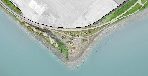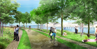

Construction of the huge new Expedia campus along the Seattle waterfront includes a rebuild of a section of the Elliott Bay Trail as the path transitions from industrial Interbay to the waterfront.
The new trail will soften what today is a sharp turn in the trail at the mouth of the Smith Cove Waterway, which should be a significant improvement to the trail, creating separate walking and biking paths and expanding the surrounding park space.
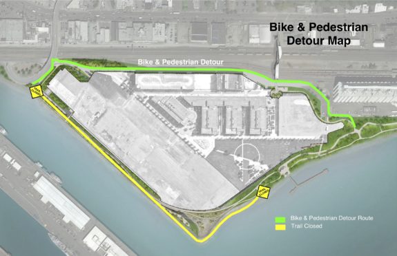
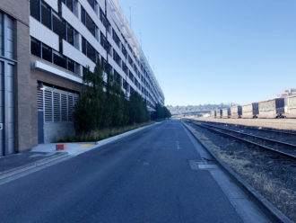
But trail and utility work will require a detour for more than a year. Originally scheduled to begin in mid-July, the detour start has been pushed back to August 1. Expedia has also made changes to the initial detour plan, which now includes a temporary trail along the low-traffic Alaskan Way W between W Galer Street and the grain silos. Though the detour route is less scenic than the current trail, it is actually a little bit shorter:


“After consultation with SDOT and advice from Cascade Bicycle Club, we are implementing additional safety measures,” Expedia spokesperson Annie Gustafson wrote in an email. “Perhaps most significantly, pedestrians will no longer be routed over the Helix Bridge during the temporary closure. Instead, they will share an 8-foot lane with other trail users.”
Though the detour is being pushed back a couple weeks, Expedia still expects the reopening to happen on schedule in fall 2019.
More details from Expedia:
Summary of safety measures during Elliott Bay Trail detour starting Aug. 1:
- Moved the temporary pedestrian trail to Alaskan Way.
- Bikes/peds to share an 8’ lane. Large delineator “candles” will be placed on the east edge of Alaskan Way to create the shared bike/pedestrian lane for the entire length of the reroute.
- The remaining 14’ along Alaskan will be a single lane of vehicle traffic that will be regulated by flaggers during work hours, 6:30 a.m. – 3 p.m., and by a portable traffic signal during nonwork hours.
- Additional bike/ped stenciling or “sharrows” will be added to Alaskan Way at 100’ intervals
- Lower speed limit: 15 mph
- Motor vehicle crossings will be demarcated with painted indicators
We would like to thank Cascade, in particular, for their strategic counsel on the reduced speed limit and the separate bike/ped lane on Alaska Way.


Comments
11 responses to “Year-long Elliott Bay Trail detour near future Expedia campus starts Aug 1”
The revised reroute is good news. I bitched to everyone I could think of regarding SDOT’s original plans for bikes and peds during the trail closure, which was much worse than this updated plan. But it still seems ridiculous to me to close a public waterfront trail for an entire year (included big chunks of two summers) so that a private business can build their Dreamhouse.
“Large delineator “candles” will be placed on the east edge of Alaskan Way to create the shared bike/pedestrian lane for the entire length of the reroute.”
I’m not a fan of these. If you ride the stretch of 34th in Fremont that connects the Burke Gilman Trail to the Fremont Bridge, you’ll find these knocked over and strewn about in the bike lane. If this route is supposed to last for a year, they should use something more stable like concrete blocks, or just paint stripes so that at least there won’t be hazards to crash into.
That spot right at the tip of the closure when it turns from East/West to North/South was a retreat for me when I regularly rode this trail. I’m saddened to see that it won’t be accessible for a year. It meant a lot to me to sit there and clear my head before continuing through Magnolia and into Ballard. I’m not sure how many others may have but that spot gave me a lot of peace when my life was very erratic.
An 8′ temporary MUP without a reasonable on-street alternative? Yuck. This on a road that’s so empty that I used to use it as an empty place to run speedwork loops (when I lived closer to downtown), running down the middle of the road.
What does one-way vehicle traffic doing 15 MPH need 14′ lanes for? Any street-legal vehicle should be able to handle 11′ lanes (really any vehicle that can’t handle 10′ lanes at 15 MPH will have severe mobility issues in any city)! And 11’/11′ is easier to set up than 8’/14′ because the delimiter would sit on the existing median stripe!
All this would have been super easy if this street had sidewalks. Pedestrians (and particularly slow/wobbly cyclists) use the sidewalks, cyclists use the street along with very low levels of motor-vehicle traffic that would, for the time, be significantly calmed by the presence of all those cyclists. 15 MPH speed limit for cars, bikes do whatever (because we’re capable of politely passing eachother within a standard traffic lane). No malarkey about how there’s not room because of the train tracks — this road is adjacent to a private lot, and in many situations private lots cover sidewalks and land owners are required to build and maintain sidewalks. I hope that, when Expedia builds out, they do build and maintain sidewalks on their side of the street. They may not be used much most of the time, but when people have to detour around we’ll be glad they’re there.
It’s not 14’ lanes each way. It’s one 14’ for both directions. Like a low/traffic residential street. People who feel comfortable in the street can still bike there. The trail will be good for people on foot and some people on bikes.
Description says (emphasis mine), “The remaining 14’ along Alaskan will be a single lane of vehicle traffic that will be regulated by flaggers during work hours, 6:30 a.m. – 3 p.m., and by a portable traffic signal during nonwork hours.”
The flaggers and portable traffic signal would be to make it a one-way street that switches directions, right? I don’t think this would work as a narrow two-way street. On residential streets vehicles too wide to pass by eachother at the narrowest points (where it’s constrained by curbside car-parking) have regular opportunities to get past eachother at intersections. Here they wouldn’t.
So it’s the 8′ path or waiting for flaggers. That bad choice seems unnecessary — the drive-side shouldn’t need more than 11′ for an alternating-direction lane.
Some of the motor vehicles that use the road might be large trucks, and you need some amount of separation to keep everything safe, which the excess lane width effectively is.
For the most separation we need to keep the trucks’ lane position far to the outside of the road. The least effective way to do that is to give them excess width because on average they’ll drive down the middle of their lane, wasting half the excess. On curves they’ll tend toward the inside of their lane, so on curves toward the path we’ll have a narrow trail and very little buffer. An explicit buffer would push them all the way over, actually achieving the objective. And expanding the trail instead would be best. It would push the trucks all the way over, and then trail users could squeeze together when large trucks are passing but otherwise use the full (i.e. still substandard) 11′.
Looking at the King County parcel map: the trail, from just east of the sharp corner, then north until it hits the dead end of 16th Ave W, is on private property, owned by a “Cruise LLC”, which appears to be Expedia’s real estate arm.
That’s not unprecedented for a public trail in Seattle, but seems like an oversight. I wonder if Seattle will ask for ROW of this section of trail.
Curiously, looking through Centennial Park shows a hodgepodge of public parcels owned by the State, the Port and various City departments. These days, that park would have never gotten built.
I would love to see a detailed plan that maps out why this will take a whole year to complete. Let’s be real though, this is all about removing the large bushes on that corner that are obstructing the water view from the Expedia building.
I was just in Victoria and was amazed to see that construction on Pandora St., which has a two-way cycle track involved taking a lane from traffic and providing both a pedestrian and a cycle lane, the latter separated from cars by jersey barriers. It’s what you do when people not in cars are an actual priority.