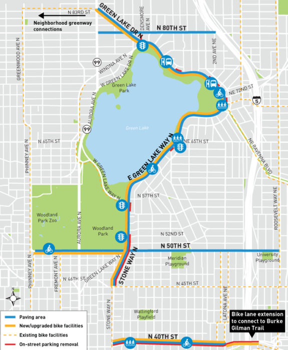
SDOT has grouped a bunch of Green Lake and Wallingford area paving projects together, designing and planning construction of them all at the same time. Because paving projects essentially wipe the street design clear, they are our best opportunities to build elements of the Bicycle Master Plan for little extra cost. The city can rehab existing infrastructure and improve safety using the same dollars.
Though the projects in this group were chosen for paving purposes, many of them happen to lie along routes designated for bike improvements. And the city’s plans are so far mostly very strong, including a two-way protected bike lane around Green Lake, uphill bike lanes on N/NE 40th St and improved bike lanes on N 50th St where it passes under Aurora.
You can learn more and weigh in on the projects through SDOT’s online open house. Responses are due Wednesday (tomorrow), so don’t procrastinate.
The repaving group covers a total of six miles. And though the city’s plans are a good start, a neighborhood group calling themselves Green Lake and Wallingford Safe Streets has organized to push for even more ambitious options.
Green Lake Way
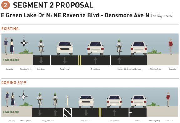
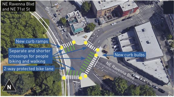
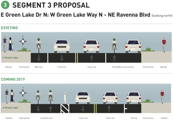
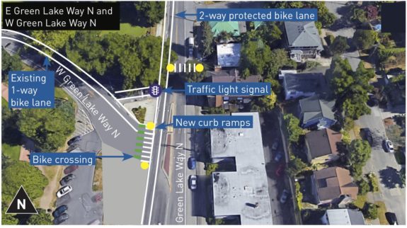
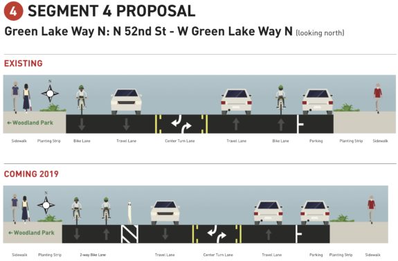
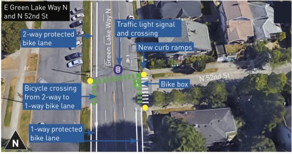
The biggest changes of all are coming to Green Lake Way between N 83rd Street and N 45th St. The messy intersection at the north end of the lake will get a redesign and a new traffic signal, and the current paint-only bike lanes around the east half of the park will become a new two-way protected bike lane on the park side of the street. These are major upgrades to a major bike route.
The weirdest part of the whole plan is the transition from one-way bike lanes to the new two-way bike lane at N 52nd St. It would be cool if planners could find a way to do this transition at N 50th St instead, perhaps as part of a redesign of that awful intersection. The team currently does not plan any significant changes there, but they have heard loud and clear from basically everyone that they hate that intersection. It’s also worth noting that people walking have it the worst there, so a remake is very needed.
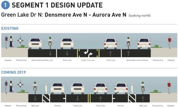
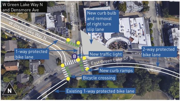
Here’s a look at the planned Green Lake Way changes starting at N 83rd St (a major bike connection across Aurora to Greenwood) and moving south: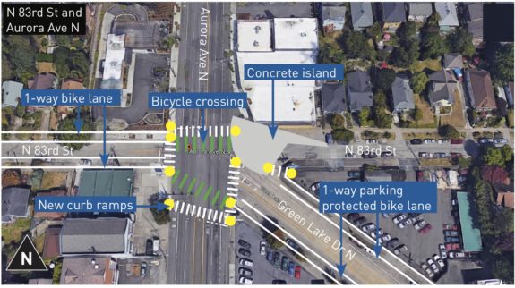
N/NE 50th St
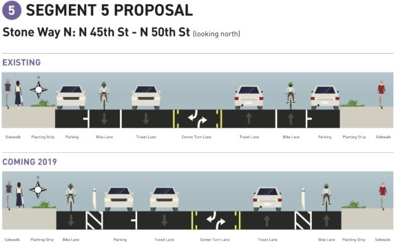
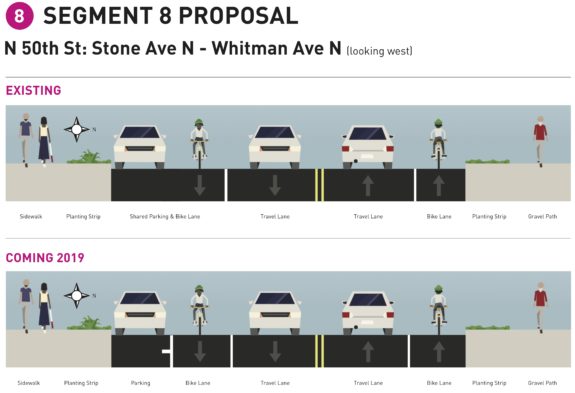
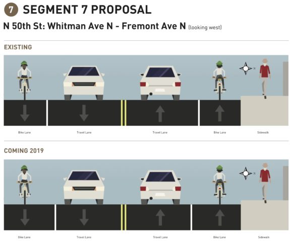
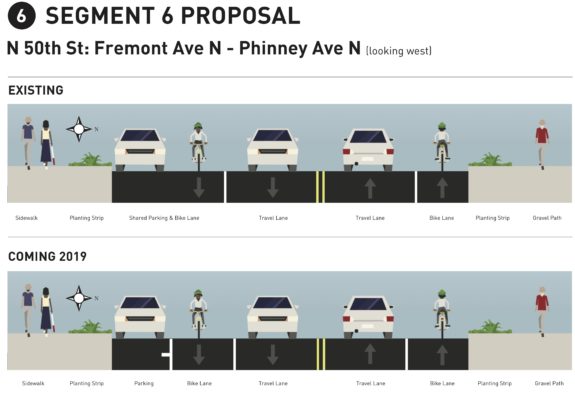
N 50th St is one of the few precious Aurora crossings for people biking. The city’s plan would slightly widen the existing paint-only bike lanes, but that’s pretty much it.
Really, N/NE 50th St should get a road diet for its whole length with bike lanes and a center turn lane added. Its outdated four-lane highway design has no place in a neighborhood. SDOT’s own experience with such safety projects has an amazing safety record, even if the skinny paint-only bike lanes they usually include are not the highest quality and do not achieve an all ages and abilities standard. There are no bus routes on 50th, so the decision to leave the road in its four-lane design is purely for the purpose of moving cars at the expense of safety.
But even if the city does not give 50th a safety redesign, the team should at least be looking at how to create a better I-5 crossing for people walking and biking. There are so few options for crossing I-5 that we can’t ignore any opportunity we have to improve them when we have the chance. (Full disclosure: I live nearby, so I have thought a lot about these I-5 crossings)
It seems like there is potential to remove an eastbound general purpose lane on the bridge by changing the right lane of 50th as it approaches 5th Ave NE into a right-turn-only lane for the many people headed to southbound I-5. That could possibly improve things for people driving (or at least not make much of an impact) while also freeing up a lane of space on the bridge.
One option would be to build a two-way bike lane on the south side of the bridge in the space vacated due to the new turn lane. Then new two-way bike lanes on west side of 5th Ave Ne and the east side of 7th Ave NE could connect people between 47th and 50th on both sides of the bridge. This would create an at least usable route for people trying to get between Wallingford and the U District without mixing with stressful traffic on 45th and 50th Streets.
If SDOT also constructed a two-way bike lane for one block on 5th Ave NE from 50th to 51st, that would connect people to a relatively flat neighborhood route connecting to Ravenna Blvd and NE 65th Street. It’s not a perfect or complete option, but it would be a huge step in the right direction. Here’s the basic idea:

These improvements would also be poised to plug into elements of the U District Station Mobility Plan currently in design, which include a possible NE 45th Street I-5 crossing and bike routes to the under-construction light rail station on Brooklyn.
And this concept would save an enormous amount of money compared to the unfunded solution noted in the Bicycle Master Plan: A NE 47th St bike/walk bridge over I-5. While that would obviously be very cool, it would be much wiser to make the two existing bridges nearby safer rather than spend an enormous sum on a single crossing. Save that kind of investment for parts of the city that don’t have any other I-5 crossing options (like Beacon Hill or the far south and north ends of the city). The only way a NE 47th St crossing makes sense it as part of a larger vision like what Lid I-5 is proposing. Until then, people need ways to get between these two neighborhoods using the bridges we already have.
N/NE 40th St
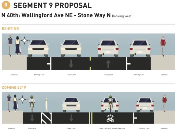
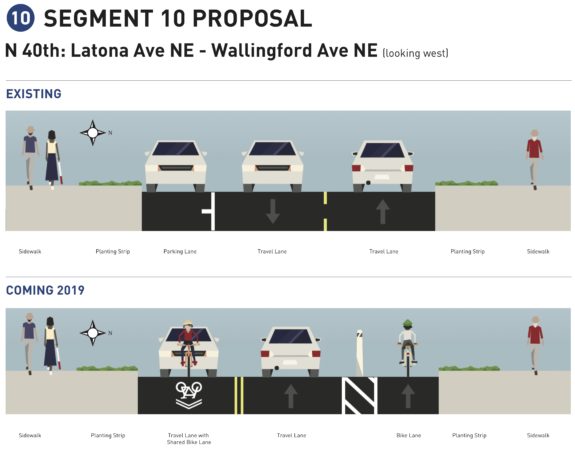 N/NE 40th St will get bike lanes in the uphill direction between 7th Ave NE and Stone Way. The Bicycle Master Plan calls for “in-street, minor separation” bike lanes here. The city’s plan more or less assumes you can find your own way downhill, but might need some extra space and time headed uphill. It’s not a perfect solution, but it will be a big help on those climbs.
The projects were all originally planned for construction in 2019, but now it sounds like some of them may be pushed back to 2020.



Comments
13 responses to “Green Lake/Wallingford paving projects create opportunity to make huge bike improvements, comment by Wednesday”
SDOT really should consider making the intersection of W Green Lake Way N and Densmore Ave an all way stop. Adding a full signal costs on the order of $100,000 – $250,000 and it seems that an all-way stop here would work fine.
SDOT has concerns about traffic backing up past Wallingford. So monitor that with the all-way stop and if it is an issue, then come back in 3 or 6 months and put in a signal. If it’s not an issue, we just saved a quarter of a million dollars that we can use to build 2.5 structured parking spaces or a mile of protected bike lanes.
I wish they’d include repaving the short stretch of West Green Lake Drive North as it turns into Winona, that provides access to the “calmed” 77th, which provides less of an incline toward Phinney Ridge, across and beyond Aurora. Currently, bicycling across these few blocks is like riding a roller coaster because of the bog under the pavement.
I will comment on their site.
Does 52nd St. seriously propose a signal for people biking, but not people walking, or am I reading the diagram wrong? People walking need to be able to cross the street too.
The intersection diagrams are confusing because they use old satellite images overplayed with just the new bike elements. They don’t show the total road redesign or all the crosswalks. This signal will definitely have a crosswalk (today it has one of those flashy crosswalk lights)
As a daily bicycle commuter on Green Lake Drive North/East Green Lake Drive North between N 80th Street and NE Ravenna Boulevard I am concerned about the safety of the proposed “protected” two-way bike lane (see concerns below). I do not know if any of these concerns can be backed up or dismissed by safety data/studies – thoughts?
1. The likelihood of collisions and severity of injuries could increase due to the proximity of vehicle and bicycle traffic flowing in opposite directions. The “protected” bike lanes are not truly protected – westbound traveling cyclists are separated from oncoming eastbound vehicle traffic by several feet of painted lines and intermittent plastic posts. Westbound and eastbound cyclists are separated by a line of paint. With this configuration, the risk of bicycle-bicycle collisions will be increased and the severity of injuries due to head-on bicycle-bicycle and bicycle-vehicle collisions could be increased due to increased impact speed. It seems unlikely that there is sufficient space on Green Lake Drive North to provide adequate and safe buffers between bicyclists and motorists.
2. The large gradual curve of East Green Lake Drive North between Bagley Avenue North and NE Ravenna Boulevard limits the ability of eastbound vehicles to visualize westbound-traveling bicyclists in the proposed two-way bike lane. The risk of reduced visibility related to road curvature is problematic due to the decreased reaction time since bicycle and vehicle traffic will be running in opposite directions (and in close proximity). For example, a westbound bicyclist going 20 mph and an eastbound vehicle going 35 mph results in an apparent speed of 55 mph resulting in significantly decreased reaction time in this reduced visibility curve. In the current configuration with same direction of travel of bicyclists and vehicles the apparent speed is 15 mph providing increased reaction time in this reduced visibility curve.
3. “Protected” bike lanes are not adequately maintained. Regardless of the degree of protection plastic posts may provide, Seattle has a poor track record maintaining existing protected bike lanes. Plastic posts on the “protected” bike lanes on NE Ravenna Boulevard have been missing for years without replacement; fortunately the risk on Ravenna is low due to the wide one-way bike lane, large painted buffer, and wide car lane. However, on Green Lake Drive North, the risk of missing plastic posts increases significantly due to the likely smaller travel lane, oncoming traffic, reduced visibility, and reduced reaction time.
4. The two-way bike lane configuration increases the number and risk of lane crossings. Compared to the current configuration, my westbound bicycle commute would require me to cross five to six additional lanes of traffic on Green Lake Drive North and NE Ravenna Boulevard (two to three additional lane crossings at NE Ravenna Boulevard and NE 71st Street and two additional lane crossings at East Green Lake Drive North and Green Lake Drive North). Without protected bike crossing lights, I am concerned that entering the westbound two-way bike lane from NE Ravenna Boulevard to East Green Lake Drive North (at NE 71st Street) will be logistically challenging, frustrating, and with increased risk compared to the current configuration. This is already a challenging intersection for motorists with a large number of pedestrian crossings – the proposed solution adds to the complexity by diverting additional bicycle traffic across multiple lanes of traffic.
I think I would rather take the vehicle lane going westbound on East Green Lake Drive North than travel in the proposed two-way bike lane (which may end up being a step backwards in safety compared to the current configuration).
There are definitely some tradeoffs. An advantage to a two-way path in this particular location is that it eliminates most of the intersection and driveway crossings. A downside is that it makes it tricky for people biking to use those intersections! Every turning movement needs to be thought-out specifically for bikes. I guess turns to and from Green Lake Way would be conceptually like turns to and from the Broadway Cycletrack… but there isn’t as much space here for turn boxes, and there aren’t as many traffic signals. Will they even put in the turn boxes, or will they omit them and leave everyone to try to figure out why people are standing around in weird places waiting for traffic to clear (see Dexter btw. Mercer and Denny; also N 92nd St.)?
I’m about to move to a place just a little north of the two-way-to-one-way transition. So when I ride home from the north I’ll have to make one of these weird turn-box turns across traffic. When I ride home from the south I guess I’ll ride with traffic for the last few blocks. When I leave home I’ll have to cross two separate directions of car traffic followed by two separate directions of bike traffic all in one movement, sort of like turning onto the Burke from certain side streets, but with less room to negotiate things. Maybe the best hope is for effective traffic calming to slow people down around these intersections?
I like the idea of more protection from cars here. I ride between Wallingford Ave and Ravenna Blvd both ways everyday. I wonder about all the debris that seems to collect during the winter at the curb on the lane closest to the lake. I recall that every winter there are times when there’s so much crap in the bike lane one the lake side, that it’s necessary to leave the bike lane for a bit. How’s that going to work in the 2-way set up. I know that they clean the street/bike lane sometimes, but don’t think they will be able to get to it with all the poles that will be put up for a protected lane? (Riding counter clockwise on this stretch at rush hour is really terrible, so I still do like the idea of a protected lane.)
Given daily experience with the protected 2-way bike lanes on Linden between 130th and 145th, there can be issues. Drivers, esp newcomers, are not careful about crossing/blocking them. The parked cars form a screen making a “right hook” collision more likely. Even postal vehicles, presumably “experts”, have been known to not “look right”. These are probably not issues as long as 2-way is only used in areas where no roads enter the park, but it’s still non-standard and potentially confusing.
Does Seattle have street-cleaning equipment that can fit in the bike lanes?
I don’t know about Seattle street cleaning equipment, but WSDOT invested in specialized street cleaners for the SR-520 bridge bike/pedestrian path:
https://wsdotblog.blogspot.com/2017/12/sr-520-trail-wsdot-maintenance-plays.html
A few comments
* Is there any protection from being right-hooked by drivers turning from Green Lake Way N to W Green Lake Way N? That’s the point where I repeatedly come close to getting hit – drivers overtake me on the left then slam on their brakes and cut me off with a right turn.
* Will the east-bound bike lane on W Green Lake Way as it approaches Green Lake Way N get any protective poles? I’ve almost been hit there by impatient drivers who swerve into the lane thinking it’s a general purpose lane, and want to get out of the line of people waiting to make a left turn onto Green Lake Way N.
I don’t understand the transition if you are biking Stone/Green Lake Way northbound from 50th to East Green Lake Way. It seems like most bike commuters on that stretch are just getting up to a good pace, and to stop at 52nd would kill that momentum. Will all cyclists need to stop at in the bike box at 52nd, or does northbound Stone become a sharrow for bikes who don’t want to wait at the light? Merging over at 52nd will be great for those of us who want to veer left onto West Green Lake Way, but I can’t picture how many of the cyclists who plan to continue up East Green Lake Way will stop, wait 30-90 seconds for a beg light, and merge west to a two-way bike lane. Am I misunderstanding?
I guess I don’t understand how north-bound cyclists make the transition from one-way bike lane on the right side of the road to the two-way protected bike lane on the left. I’m confused about both the beginning of the two-way (Stone/Green Lake Way and 52nd) and the end (Green Lake Dr N/Densmore/East Green Lake Dr N).
I suspect the stop light at the end of the two-way near Densmore makes more sense, but I’ve been so frustrated with the long waits for pedestrian or bike access at the intersections of Aurora/N.77th and Aurora/Green Lake Dr N that I’m not thrilled at another stoplight and beg button situation.
So the question becomes – is it worth the trouble to wait who knows how long for another light to cross over to the protected bike lane vs. just keep riding northbound in the car lane, then cut over to the left at your leisure when there’s a break in the traffic or you come a light that is already red. Or, if you’re making a right turn somewhere before Ravanna, maybe it’s easier to just ignore the protected bike lane completely and take the car lane all the way.
This is a problem with these two-way protected bike lanes in general – the transition in and out of it is very annoying. Hopefully, this light can be designed to change reasonably quickly. But, I’m not holding my breath.