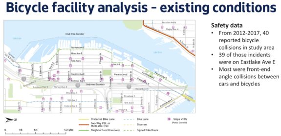
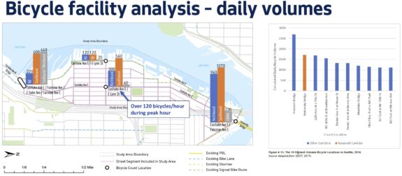
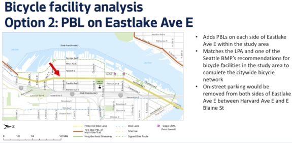
 I thought we had already established this a few years ago during public outreach for Roosevelt RapidRide, but SDOT has tried again to find an alternative to building bike lanes on Eastlake Ave. And, just like before, the results are clear that Eastlake is the only good option.
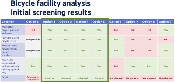
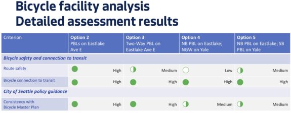
The project team presented the latest study to the Seattle Bicycle Advisory Board earlier this month, and they found that the previously planned protected bike lanes on Eastlake are the best option for the project by essentially every measure other than car parking. They conducted a serious study of nine options, then narrowed that down to four, then found what anyone who bikes in the area could have told them: Eastlake is the only continuous option without very steep climbs that serves Eastlake businesses and connects the U Bridge to downtown.
And let’s not forget that the final phase of SR 520 work should include a bike connection from Eastlake to the 520 Trail, making Eastlake Ave even more important.
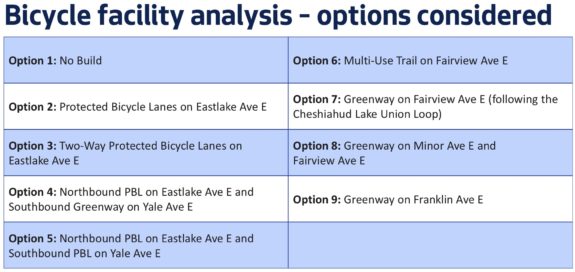
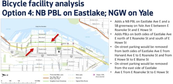
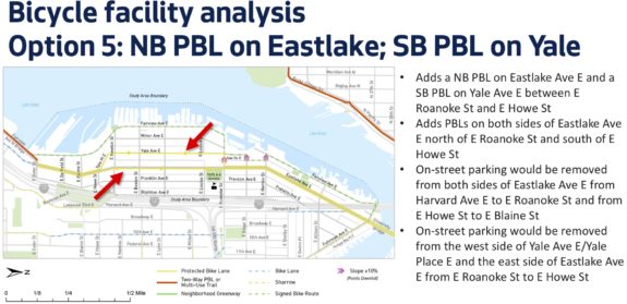
The study explored a new concept for the route that is, frankly, quite baffling. The city would build a protected bike lane northbound on Eastlake Ave, but would route people headed southbound down a steep 11 percent grade hill on E Roanoke Street to Yale Ave E, which curves to meet back up with Eastlake south of the neighborhood’s main business district (the city’s study did not seem to factor downhill grade in its analysis even though a steep downhill can also be a barrier to biking, especially if you have to make a turn mid-hill like this plan would require). One version would turn Yale into a one-way neighborhood greenway, which is not really a thing. Another version would include a protected bike lane on Yale, which would remove even more car parking than the Eastlake bike lanes.
The idea of splitting the bike route in this way is inherently flawed and would result in people biking southbound on Eastlake Ave without a bike lane. Not only is it confusing to essentially detour one direction of the bike route, but people headed southbound would have no safe way to access the neighborhood’s business district.
And since Eastlake Ave is where 39 of 40 reported bike-involved collisions occurred between 2012 and 2017, addressing bike safety on Eastlake Ave should be paramount.
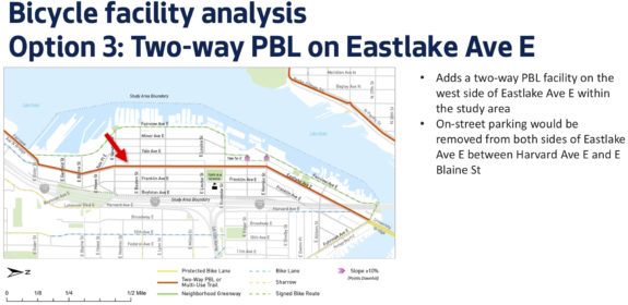
You can see the options explored below to decide for yourself (excerpts are from this presentation PDF):


Comments
19 responses to “After further study, SDOT finds that Eastlake Ave still needs bike lanes”
I guess we’ll be revisiting every single planned bike project under Durkan’s SDOT.
Along with every transit project.
Actually, quite a few people (including myself) bike through this neighborhood on Yale. It’s a much nicer street than the current Eastlake. As you pointed out it doesn’t work if you’re trying to get to Eastlake businesses, but I feel that’s a minority of the bike traffic. Many people and businesses in the neighborhood are going to fight the loss of parking, and Yale would have been a decent compromise.
Having said that, I wish SDOT would just get on with it. The decade of planning that seems to go into every. single. project. is excruciating.
I think people who say they are biking on Yale are actually thinking of Minor Ave E. Does your route have cars parked on only one side for most of the route? Is it a block up from Fairview? That’s Minor (I take it all the time).
Yale is narrow with cars parked on both sides. It is really one block over from Eastlake, the map makes it look like two b/c it shows the alleyway between Eastlake and Yale.
The Yale option is a complete waste in my opinion–just go to Fairview (Chesiahud).
Exactly. If you must meander, and least meander down something with views.
Sure wish SDoT would have included a Boylston Ave route in the study. The Eastlake Ave proposal crosses 9 intersections and 33 mid-block curbcuts between Allison and Newton. The Boylston Ave route has two intersections and zero curbcuts. The Eastlake proposal eliminates all LOAD zones south of Louisa Street, forcing paratransit, jitney & shuttle passengers, plus take-out and delivery drivers to dash across traffic lanes. Not a problem on Boylston. And the SR-520 Trail actually will terminate at Boylston, connecting with Lakeview/Melrose or through the Colonnade Bike Park. But SDoT can be myopic sometimes….
This again? There’s no route through Boylston that has a reasonable grade and isn’t going to have to contend with crossing I5 onramps. Additionally you’re asking for an entirely separate construction project beyond the planned revamps that get you both bike and bus facilities.
This idea isn’t even supported by the Eastlake community council anymore.
I agree, Yale is a big issue. Getting from Yale up/down to the loop is hard (going up) and terrifying (going down). I don’t see how the top half of the hill is any better than the bottom half, and the pavement condition is awful. Hopefully SDOT decides to do more than a paint-only “upgrade” if they choose this option (but really, why bother at that point…).
I commute from Bellevue and take Eastlake most mornings. I wouldn’t bother going down to Yale if I had to just climb back up to Eastlake.
Eastlake *really* needs road maintenance. Bike lanes would be great, but concrete streets need maintaining.
Eastlake is beyond maintaining, it needs a complete rebuild. It’s asphalt on top of (what I assume is) brick. Similar to 45th between I-5 and the Ave, heavy traffic causes the asphalt to “flow” into weird ruts since it can’t adhere to brick very well.
I have a hunch that SDOT is dragging their feet in hopes that the street car gets extended to the U-District.
Are they just crossing their fingers hoping that the streetcar gets extended? It’s up to them to do so. Also, streets all around the city are in horrific condition. Why are they incapable of maintaining any of Seattle’s roads? I know our government is revenue-starved due to our regressive tax code, but it’s ridiculous nonetheless.
Eastlake is not a problem going south bound in the morning and north bound during evening commute hours. At all other times it is horrible; I use Yale (much faster than Fairview). The Yale route could be greatly improved by making it a greenway and improving the connection at Edgar. I suggest adding a traffic light at Edgar and removing parking on Eastlake between Harvard and Edgar to allow for protected bike lanes on both sides of the road. Yale reconnects to Eastlake on the south end with only a modest climb. The hills between Yale and the Eastlake businesses are a bit challenging but I climb them and I’m a 60-year old woman.
Sure, the nicest option would be removing the parking and having bike lanes on both sides of Eastlake but maybe a compromise on the amount of parking to be removed would get us to a good result a whole lot sooner.
I am concerned about safety going down the Roanoke hill, making that left turn right in the middle of a steep hill. If you have to stop in the middle of the turn, it’s easy to tip over.
I am also concerned that asking cyclists to turn gives drivers an excuse to honk at and pass too closely those that go straight, either because they miss the turn, or they need to access the local businesses.
A valid alternative to eastlake would be fairview, except that it’s interrupted at mallard cove. Unfortunately, in the 1980’s, it gave away its rights to the then developers. If the city were to invoke some sort of eminent domain, it could create a bike route near or along the lake that would allow passage without a hill climb. I don’t know if this is remotely possible, but I sure would like to see it happen.
Yeah, I dream of a floating path like Portland’s Eastbank Esplanade that goes out around Mallard Cove. It would have an awesome view of Gas Works and would easily become an attraction of its own. But that’s a huge project without a budget. And even if it were built, Eastlake Ave should still have bike lanes so people can access the businesses and destinations there. I don’t really see them as mutually exclusive.
The Eastbank Esplanade cost $30 million in 2004 dollars, though $10M of that was for Steel Bridge upgrades. So even if it were $20 million for the Fairview Esplanade, it would take an enormous and long-term effort to get all the funding. Plus it would need to somehow open for the moving of house boats and would need some kind of permanent underpass or draw bridge for smaller boats and I don’t even know what the Coast Guard and fire dept would think of it. It’s basically just a dream.
A more realistic option would be a shoreline trail, requiring significant changes to Mallard Cove and possibly some buying of land (I think a second unrelated property might be affected, too). I know the city has right of way through there, but it looks like that right of way crosses the water, not the shoreline. It’s quite a mess.
Yes, on further thought I don’t see them as mutually exclusive either. Fairfiew really is more like a greenway and would be hard to make into a good commuter route since it is narrow and barely has room for parked cars as it is.
Eastlake it is, then !
SDOT should consider several modes simultaneously: pedestrians, transit, bikes, and general purpose traffic. Perhaps several parallel facilities are required. Transit and peds should have priority on Eastlake. To remove most of the parallel parking, some could be replaced by a municipal garage with paid short term parking and several stories of wood frame housing atop it. Transit should stop in-lane; intending riders should have a safe connection between the sidewalk and the bus. Fairview Avenue East is already a defacto woonerf; let’s make it official. Yale Avenue East could have to 8 to 80 all ages bike facility. Eastlake Avenue East could have bike lanes or sharrows for the fast confident riders. perhaps the topography provides a clue; East Lynn Street is the crest; bike lanes and bus bulbs could be provided up hill, southbound north of Lynn and northbound south of Lynn; sharrows and no parking in a wide outside lane going downhill.