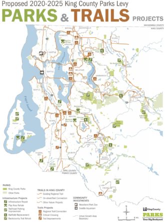
About 80 percent of the King County Parks budget comes from a levy that goes to voters every six years, and King County Executive Dow Constantine is proposing an even bigger levy to send to voters this autumn for 2020–25.
The $738 million proposal would cost the average property owner about $7 per month, $2 more than they pay under the expiring levy according to a press release from King County.
Among many investments in Parks facilities and programming across the county, the next levy would complete regional trail connections that have been in the works for a long time. It would also close funding for some of the most difficult and iconic segments of the Eastside Trail like the Wilburton Trestle. Here are some highlights from the press release:
- Opening to the public nearly 12 miles of the 16-mile-long Eastside Rail Corridor, making accessible the Wilburton Trestle and connecting the cities of Renton, Bellevue, Kirkland, Redmond, and Woodinville
- Completing the Lake to Sound Trail, a 16-mile-long paved connection that extends from Lake Washington in Renton to Puget Sound in Des Moines
- Paving the final segment of the East Lake Sammamish Trail to complete the 11-mile-long corridor and connect the cities of Redmond, Sammamish, and Issaquah
Renton in particular stands to see some major bike improvements from the Lake to Sound and Eastside Trails. After these projects are complete, Renton will have quality access west to the Green River and Interurban South Trails as well as north via the Eastside Trail connecting to the Mountains to Sound, and 520 Trails.
The levy map also shows a connection from the current north terminus of the Cross Kirkland Corridor (Eastside Trail) at Totem Lake to the Burke-Gilman and Sammamish River Trails. The Lake to Sound Trail will make connections in SeaTac, Tukwila and Des Moines. And the Green River Trail should finally connect to the Duwamish Trail in South Park.


Comments
9 responses to “Proposed $738M King County Parks levy would fund Eastside, Lake Sammamish and Lake to Sound Trails”
I still dream of seeing the Preston–Snoqualmie Trail actually connect to Snoqualmie.
And also having a bridge over Preston-Fall City Road, avoiding a very awkward crossing with switchbacks down, switchbacks up, plus a blind curve with 50 mph car traffic.
Where would the connection be? There is a pretty big elevation change, right?
It’d just need to continue along the Northern Pacific ROW that it follows to get to its current farthest reach. Old topographic maps will show the old railroad route.
Did some digging, and it looks like there is a trestle.
https://twitter.com/206Husky/status/1100164313686233088
There are two proposals I’ve seen. Both involve fixing up the existing trestle. One follows the existing rail bed and connecting to Centennial trail near the Railroad Ave/202 bridge. The other uses a set of switch backs to climb the hill up to Allman Ave, with a new parking lot installed at the corner of Allman and Snoqualmie Parkway.
[…] Proposed $738M King County Parks levy would, among other things, fund a lot of bike infrastructure […]
I long for the day we see Landburg Dam/Park connected to Rattlesnake lake! The railroad grade is still visible on google.com/maps And Landsburg connects to the Cedar River Trail, with Rattlesnake Lake connecting to the Mountains/Sound Cascade to Spokane trail.
I’m with you on this Gary, give me the inside passage to Rattlesnake Lake and beyond! It would be amazing!