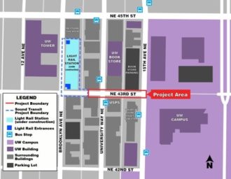
 U District Station is going to change everything about the neighborhood when it begins operating in 2021, and the streets should reflect that. Located at Brooklyn Ave and NE 43rd Street, the main station entrance should be supported by streets that reflect the walking, biking and transit focus needed to help it succeed and thrive.
Today, NE 43rd Street dead ends into the station construction site halfway between the Ave and Brooklyn. The street also dead ends into UW Campus at 15th Ave NE. So it is not a necessary street for car movement, making it a great candidate to go car-free. Unfortunately, concepts floating around shy away from going fully car-free, which is a shame.
One big goal needs to be increasing the walking space to accommodate the more than 20,000 daily riders expected. Another goal, of course, is bike access. Bus access is a bit up in the air because it’s not fully clear whether buses will need to operate on the street or if they would be better serving the station via Brooklyn. However, plans seem to assume westbound bus operations complete with new trolly wires for the re-routed bus routes.
The U District Mobility Group and SDOT have two different concepts at this point, and the UDMG is currently taking feedback via an online survey.
Both concepts significantly widen the walking spaces, and both have potential. But the devil is in the details for both of them. So I’d like to hear from you all in the comments below.
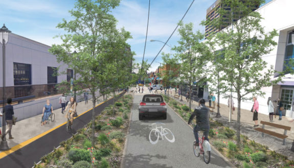
SDOT’s counter-flow bike lane
 SDOT’s design definitely looks a little strange at first. It has a protected bike lane eastbound, but the single westbound lane would be shared by people biking, buses and even … cars? Well, this is where the details become important. The SDOT design would allow all vehicles on the one block between 15th and the Ave, switching to transit and bikes only west of the Ave.
How will the city prevent illegal driving west of the Ave? This question is vital. As we have seen with the Bell St “park” in Belltown, signage alone will not be enough to prevent people from driving there. And if this street gets clogged with cars, the bike access, transit efficiency and walkability goals will be hurt. But if they have a physical car diverter plan, then this option could work.
If planners decide against serious, physical traffic diversion, then they should build bike lanes in both directions. And there also needs to be space for people biking to safely pass buses at bus stops or this shared lane concept won’t really work as a bike route.
The city describes their design as curbless, so you could imagine it as Bell Street, but with a separated counter-flow bike lane.
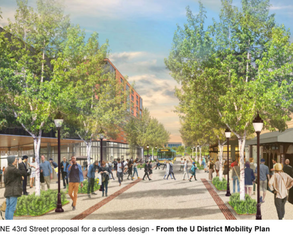
U District Mobility Plan’s wider curbless concept

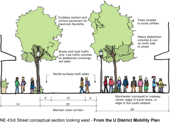
The U District Mobility Plan concept looks a lot like the Bell Street “park” in Belltown and gets rid of the bike lane. It’s a curbless street, and road edges are marked by tactile strips for accessibility. The concept would be open to transit, biking and “local traffic.” Hmm.
As we’ve learned from Bell Street, this design works really well when there are no cars, but falls apart once people start ignoring the signs banning through car traffic. And since there will be significant demand for pick-up and drop-off at the light rail station, this street concept would fall apart if it becomes clogged with cars. And simply posting signs will not work. Physical car diverters are needed, which is a challenge when you are trying to allow buses.
But if car traffic is removed or severely limited, then no bike lane would be necessary. The benefits of a curbless street is that people can take over the space. Sidewalks can spill into the road, which is a good thing. You can imagine cafe seating and street festivals and all kinds of cool stuff here. But it has to be done right or cars will just fill the whole space like they always do.
This concept is also set up better for going car-free, which should be the goal for this street, especially for the blocks adjacent to the station.


Comments
11 responses to “Which NE 43rd St concept do you like best for U District Station access?”
At a minimum, having this road be vehicle-free between the two alleyways would be an amazing community asset. Imagine a huge pedestrian-only crossing of 43rd, better bus stops, and a ton of space for people to hang out!
From the perspective of bicyclists, I agree that more can be done to take full advantage of this two block section of NE 43rd Street connecting the pending light rail station to the Ave and UW campus. This intersection of 43rd and the Ave is the very heart of our neighborhood, our commercial district, and achieved a Walkscore of 100 (out of 100) before the station construction began.
The U District is unique in so many ways: highly walkable with a human-scaled shopping district, a young and diverse demographic, dozens of legacy small businesses who provide ‘third places’ for community, the best transit connections outside of downtown, and in close proximity to the Burke-Gilman bike trail.
However, intense change is on the horizon with the opening in 2021 of our second light rail station, a huge population increase with the campus master plan, and our recent high-rise upzone reaching building heights of 320’. It will become downtown north. All of this will transform our neighborhood in 5-10 years into what should be a laboratory for how to make a dense, urban environment affordable, sustainable and livable.
Robust, safe, and connected bike infrastructure is essential to make our metamorphosis successful, and become a showcase for other neighborhoods and cities. Last year, our community came together to develop the U District Mobility Plan and set our priorities (udistrictmobility.org/plan) with one goal: a holistic, multi-modal station area mobility plan for the U District.
Unfortunately, the embarrassing lack of coordination among City departments and transit agencies jeopardizes this outcome, and shows how little we learned from the disappointing cross-modal access conditions at the Husky Stadium light rail station. We must, and we can do better for all ages, all abilities, and all modes:
1. Make 43rd pedestrian and bike only (udistrictmobility.org/pedestrian)
2. Route buses on Brooklyn for direct transfers to the station in all directions (busesonbrooklyn.org)
3. Create a safe, attractive street environment for mid-week farmers market and festivals
4. Help local small businesses resist displacement by making space for outdoor dining
5. Tell SDOT that only a pedestrian option will receive funding (udistrictmobility.org/proviso)
Thank you.
No buses or cars on 43rd. Bikes and peds only. Bigger question: What’s being done on the 45th crossing of I-5? It’s barely safe for pedestrians, and definitely not save for less-than-expert cyclists.
Alas, there is much to redesign in preparation for the station opening. The Mobility Plan suggests one idea (page 52) for connecting bikes safely from Wallingford to what is their nearest light rail station, and we have worked with our neighbors across I-5 to coordinate those efforts.
However, our U District Mobility Group focused on the streets immediately adjacent the station area to produce an implementation roadmap on streets with funding already allocated for rebuilding. Crossing I-5 involves coordinating with yet another agency (Washington Department of Transportation), and it was beyond the scope (but not the desire) of our volunteer team and limited budget.
Ideally, the City would either fund the continuation of the Mobility Group or take over the holistic coordination critical to success for the U District. Instead, the SDOT team is narrowly-focused on 1.5 blocks of NE 43rd Street while ignoring the potential of running buses more efficiently on Brooklyn. Furthermore, the protected bike lane on their portion of 43rd disappears abruptly where Sound Transit’s portion takes over across the alley.
I agree.
First of all, it doesn’t make sense to send a bus down 43rd. Doing so would mean having the bus make turns in a very crowded area. There will be a lot of pedestrians there — more than any place in the city outside of downtown. Bus riders wouldn’t benefit. They would be stuck, while the bus slowly made a turn, then slowly made another turn (waiting for people to cross the street). Run buses up the Ave and ask riders to walk a block. Run buses up Brooklyn. Run buses on 15th if you must, and then turn on 45th (like they do today). But don’t make a bunch of turns around the station.
There is also no reason to have cars between the Ave and the alley way between 12th and Brooklyn (what is currently blocked off). There are no garages or other entrances, so there is no reason to access the area. West of that alley, there is the parking garage to the old Safeco Tower (the skyscraper now owned by the UW). That should remain open to cars and trucks. Likewise, between the Ave and 15th should be as it is now — open to all vehicles. The only reason to access 43rd is for emergencies. Removable bollards could be used to keep cars out, but allow emergency vehicles in.
It’s amazing the local government has a huge home run on it’s hand and instead, just bunts. Car free would be amazing for…well forever. It would create a safe zone for people where…there are lots of people. Yet, they feel the need to preserve space for people in their oversized, killing cars?
wow. Way to bunt, government.
Bicycle bicycle everywhere! I have a disability and I can’t. Let’s improve public transportation so it doesn’t take three bus routes and an hour and a half to get from ud to Ballard!
It’s important to note that, despite what is written on the SDOT project page, their modified alternative design does not really increase pedestrian space. Existing sidewalks are 12′ on each side. SDOT’s design calls for 11′ on the south side and 14′ on the north side. Together you’re only expanding sidewalk space by one foot, when pedestrian volumes are expected to be several times greater than that area has ever seen.
what I find disturbing is the right of way the Seattle plan devotes to drainage; that is a low priority need. also, as with Bell Street and Pine and Pike streets downtown, the one-lane profiles choke transit flow.
note Mouse comment. the U District is an urban center next to the UW campus and shared by the region. Route 44 is a clean quiet electric trolley bus connecting Ballard and the UWMC via Wallingford; it will serve two Link stations. it now is slowed by a difficult left turn to NE 45th Street from 15th Avenue NE. current turns are bad; can future turns be improved? SDOT wants to elevate it to RapidRide in Move Seattle. if the westbound trip was on NE 43rd Street, the transfer walk would be minimized. that would also be true if Brooklyn Avenue NE was used; but before the community project began, ST made clear that the station plans were fixed. has the community project or SDOT measured the pavement of Brooklyn for transit flow? on the other hand, University Way NE has had frequent transit for more than a century (e.g., streetcar, trolley bus, diesel bus, dual mode bus, hybrid bus); it was recently reconstructed with new pavement, bus bulbs aligned with the Link station (intergovernmental cooperation), wider sidewalks; transit is a main reason it is the heart of the community.
Brooklyn Avenue NE could be the north-south bike priority street. it connects NE 65th Street and the BGT via Ravenna and Cowen and Link; it has signals at the major arterials. NE 40th, 42nd, and 43rd streets could connect with the UW campus.
the Bell Street changes by Parks were awkward as transit service had to remain; it is the connection between Dexter Avenue North and the 3rd Avenue transit spine until Aurora is put together. Parks could have use Vine Street more easily, as it had no transit.
it is quite common for pedestrians and transit to complement one another.
[…] Concepts for U District Station access. […]
The problem with going “fully car free” is that everyone over 50 remembers the “pedestrian mall” and the considerable expense that was spent to reintroduce cars to these cesspits of public urination and petty larceny.
Why not do a single lane with parallel spots (like Bell Street), but make the block from Brooklyn to University one-way westbound and the block from University to 15th one-way eastbound? That would kill off through traffic without requiring barriers.