 The Fairview Ave N Bridge connecting South Lake Union to Eastlake will close for 18 months Monday.
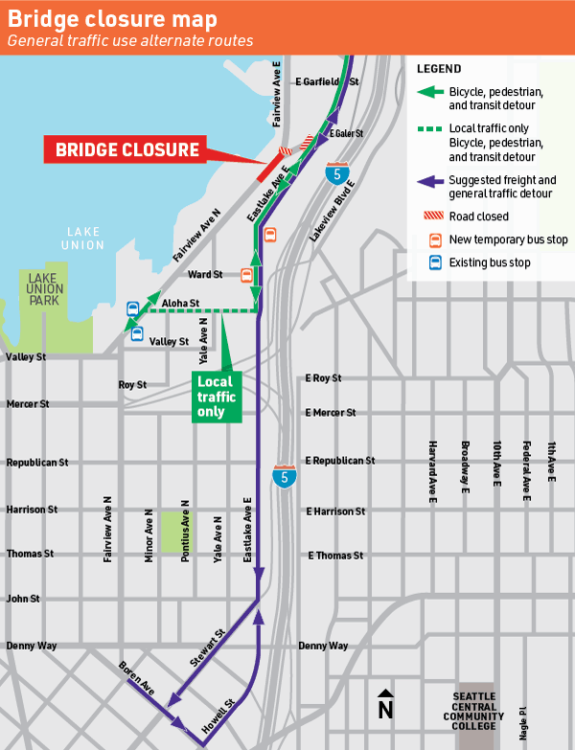
As we reported previously, the biking, walking and transit detour will be routed via Eastlake Ave and Aloha Street. People driving southbound will be directed to continue south on Eastlake Ave to Stewart Street or any of the many streets into South Lake Union along the way. Northbound, people headed to Eastlake will be directed out of downtown via Howell Street.
This is hillier than the current bridge option, for sure. But the real effectiveness of the bike detour will come down to whether they can maintain low and slow car traffic levels on the street. The plan notes Aloha as “local traffic only,” but will many people just drive there anyway? And given how many jobs are located in the area, there may be quite a bit of “local traffic.” I guess we’ll find out Monday.
Additionally, the car detour could make Eastlake Ave more stressful for people who currently bike that route. So even if you don’t use the bridge, this change may affect your route. So just be prepared and give yourself a little extra time starting Monday.
In our previous post, we also discussed some options for avoiding the area entirely.
The Fairview Bridge, which is at road level and hardly feels like a bridge when you use it, is the city’s final major timber-supported bridge. It is pretty much falling apart and is in no way ready for an earthquake. It’s one of the largest investments in the 2015 Move Seattle Levy.
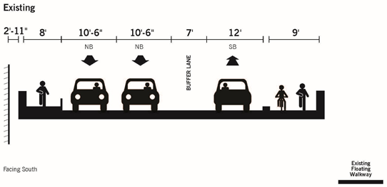
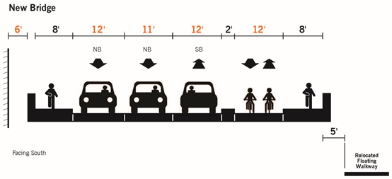
The remade bridge will have separate biking and walking spaces on the east side. It should open in 18 months, so winter/spring of 2021.


Comments
9 responses to “This is your final week to cross the Fairview Ave N bridge until 2021”
Please check this: “Crews are even installing temporary trolley wires for electric buses”; the battery feature may be used instead; there may be pans added on either side of the detour to help guide the poles to the overhead. Note the current Burke Gilman Trail related operation of Route 44 on NW Market Street.
Thanks. I’ve asked the team to clarify. I saw a note about installing trolley wires on the project page, but now I’m wondering if I read too much into it. I’ll clarify the post and update when I hear back.
In anticipation of the closure, I’ve been trying alternate routes for the past couple of weeks. Since my destination is downtown, I don’t find the Aloha detour all that useful. Traveling southbound, by the time I have climbed all the way to Aloha, it makes more sense to just top the hill and continue on and deal with the mixed traffic on Stewart. (Not to mention a construction site forces me to merge into the auto lane on my way up.) The Melrose route southbound isn’t particularly fun, but northbound will probably be my preferred route. I’m going to try the Westlake route this week and see how it blows up my travel time.
Not to mention that there’s currently major construction just south of Zymo where Eastlake is torn up in various places, and traffic is reduced to alternating single lanes sometimes in the morning for construction traffic. Sounds like Monday will be great fun. I pass through daily at 0615 or so, and I plan to see exactly how bad it is on Monday. Then, I’ll probably do the Melrose detour since I enjoy doing hills anyway.
100% This. I commute through here as well. The current detour dumps you right into a construction zone full of closed bike lanes forcing you to merge with traffic. They should have planned this better.
This is why I rarely leave the house anymore.
While passing through this area, imagine this: A simple elevator at Eastlake/Aloha up to Lakeview (similar in scale to the ones from Belltown to the waterfront) would do a lot to connect Capitol Hill, Eastlake and SLU for a lot less money than an entire new crossing of I-5 — and it looks like there’s enough right of way to build it. The cost of such a lift would surely be a drop in the bucket compared to the Mercer rebuild, massive development, Rosevelt RapidRide, and resurfacing I-5.
If paired with some other publicly accessible elevator on the west side of Eastlake Ave. this could get you from the fastest-growing to the densest residential neighborhood with very little climbing or distance required. Many potential funding sources could be tapped. It requires coordination with WSDOT and FHWA but so does everything else around there.
Take the stairs, it’s good fer ya.
I contacted the project team to ask about this and the closures of all-but-one-lane that have been happening with the new Alexandria building. They state the project will keep “one lane of traffic and bike lanes in each direction open from 7am-7pm Mon-Fri”.
I’m skeptical that will be done in time but it sure would be better than merging into traffic around a curve going downhill over metal road plates.