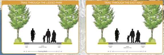
When the I-90 Trail crosses Mercer Island, it climbs up and through a park created in the 1990s to cover the freeway. Posthumously named after and Island Councilmember and Mayor who negotiated with the state to include the lidded park, Aubrey Davis Park hides what would otherwise have been a freeway trench dividing the island from end-to-end.
Mercer Island is nearing the end of its master plan update for the park, which covers the lid park and the section of the trail east of the town center. Cascade Bicycle Club is urging people to support a “futureproof” I-90 Trail design that follows modern best practices for multi-use trails. You can show up to support the trail in-person at an open house 6–8 p.m. Monday at the Mercer Island Community & Events Center.
Specifically, Cascade is suggesting:
Right-size the I-90 Trail to fit local and national design standards, so that users experience a seamless trails network across jurisdictions. As national trails standards grow to 14 feet wide, King County is already building well-loved trails to 14 feet to give all users room to safely navigate.
Make sure this high-use section of trail supports more people (using more modes) to get around the regional trails network.
Support transit access and through-traffic on the trail as East Link Light Rail and increased bus service come online near the trail’s corridor.


Comments
5 responses to “Cascade: Mercer Island plan should ‘futureproof’ I-90 Trail, open house Monday”
Imagine, if you will, an entire society designing itself around futureproof concepts
Those side-by-side images at the top of the post look identical. Are they supposed to be before/after? Is there some subtle difference I’m not seeing?
I believe those are diagrams of ‘lidded area’ vs ‘east of that’. And the one of the left says “existing width” for the paved trail, while the ‘east of that’ says 12 feet. Perhaps not the most informative bit of the document. :)
But relevant as Cascade is suggesting both of those would read 14′.
Yeah, I guess those concept diagrams are missing some context. Jeffrey is right. The master plan looks at the lid and east of the town center (the town center section is being left to the realm of light rail planning). The relevant info is that they aren’t planning to widen the trail through the park, and are planning 12’ for the east section. These widths aren’t awful or in critical need of immediate widening today, but a long term master plan should think big. For example, if some future construction project requires rebuilding the trail anyway, shouldn’t they rebuild it to modern standards?