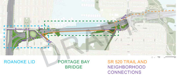
 In our post about the planned Eastlake Ave bike lanes, we mentioned that the bike route there would be part of a regional network once the 520 Trail reaches across I-5. It might be hard to imagine what that connection will be like because it is so different from the way things are today, so here’s a closer look at the latest design plans from a November report to the Seattle Design Commission (PDF).
A trail was not always part of the so-called “Rest of the West” phase of the state’s $4.6 billion 520 Bridge Replacement Project between Montlake and I-5, but a lot of organizing a few years back by advocates, including Seattle Neighborhood Greenways and Cascade Bicycle Club, made sure a biking and walking connection continued all the way to Capitol Hill and Eastlake. The project includes a new bridge across Portage Bay, a new freeway lid park near Roanoke Park and an improved I-5 crossing. Put it all together, and you get a complete biking and walking path from Eastlake all the way to Kirkland and Bellevue.
Though the project is not scheduled to be complete until 2029, the major design decisions (like whether to include a trail and lid park) have already been made, and the details will be finalized over the next couple years. So let’s take a look.
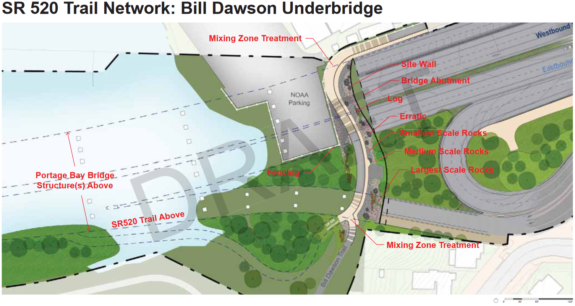
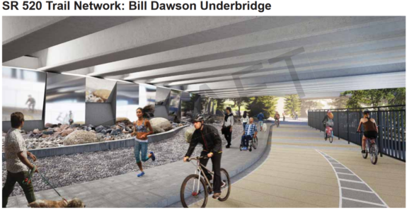 The existing trail under SR 520 near the NOAA facility in Montlake (AKA the Bill Dawson Trail) will be significantly upgraded, and it will now connect to both the Montlake Playfield and the new bridge trail over Portage Bay. So whether you come from the Montlake Bridge or are continuing on the 520 Trail from across the lake, you will travel through here to get to Roanoke.
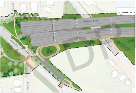 The bridge trail is on the south side of the Portage Bay Bridge. And though it will be the most gradual grade possible for getting up to Roanoke Park, it will still be a climb. Once users get to the new Roanoke Lid Park, they will need to climb up via a series of switchbacks to get up from the bridge level to the lid level. This climb will be ADA-compliant, so it won’t be too steep. But the trade off for less grade is more distance. The trail will then reach Delmar Dr E, where you have the choice to either hop into the existing bike lanes or cross the street into the new lid park.
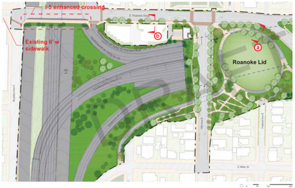
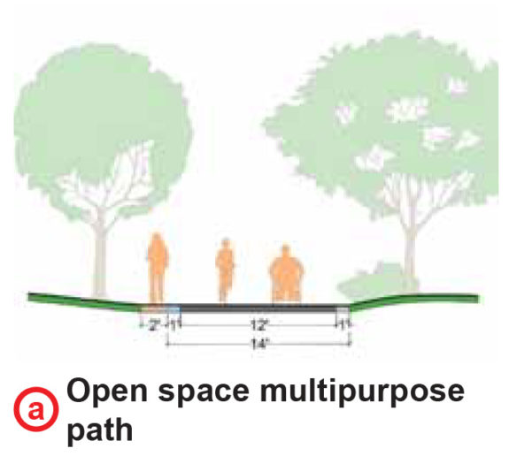
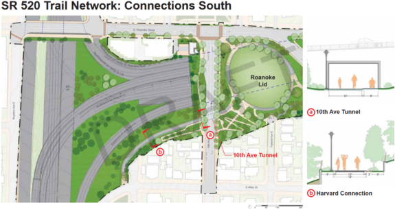
 From the lid park, you have a lot of options:
- You can connect up Capitol Hill via a new path to Federal Ave E, a good-but-bumpy side street alternative to 10th Ave E.
- You can connect to 10th Ave E like today.
- You can take the Delmar Dr E bike lane south to Interlaken Blvd.
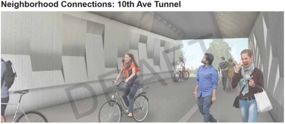
- You can go through a bike/walk tunnel under 10th Ave E and connect to Harvard Ave E, a very interesting new connection that doesn’t make a ton of sense for a lot of people today but could become quite popular once this project is complete. This stretch of Harvard Ave E follows the east side of I-5 and connects to Lakeview Blvd E near the I-5 Colonnade Park.
- You can heard north by crossing Roanoke Street into the existing Roanoke Park, where you can connect to Broadway Ave E and follow the bike route markings to the University Bridge.
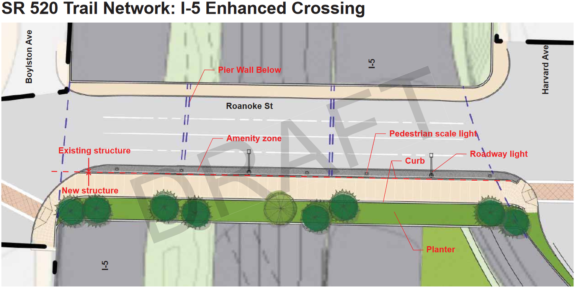
- You can head west on the widened south sidewalk on Roanoke St, crossing I-5 and connecting to Eastlake.
That’s a lot of major connections all in one place, making Roanoke Park and the new Roanoke Lid something of a bike route nexus.
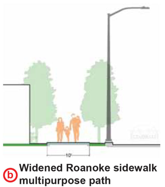
The smallest pinch point in this plan is currently the Roanoke St south sidewalk in front of the firehouse (“b” above). The bike/walk path is currently planned as a shared ten-foot sidewalk. Obviously, ten feet is better than five or six like a typical sidewalk, but that’s still a bit tight for a major bike route. It’s also not entirely clear how someone biking will get to and from the south sidewalk on the east side of I-5 to Eastlake Ave just two blocks down the hill to the west. Seattle has the better part of a decade to figure out this two-block connection. The 2014 Bicycle Master Plan calls for a neighborhood greenway, though that was created before the 520 Trail designs were complete. It needs to become a priority at some point in the next decade, but there’s no rush.
The designs are entering the final phase of work as the state puts together the project details to send out for construction bids by spring or summer 2021. Construction could begin as soon as 2023, though projects of this scale tend to get delayed. I mean, as exciting as these new trail connections are, this is still a freeway expansion mega-project.
There’s a lot to digest here. How do you see these new connections affecting your biking routes?


Comments
9 responses to “A look at the latest plans for connecting the 520 Trail to Capitol Hill, Eastlake”
I gasped when I read this part: “The project is not scheduled to be complete until 2029” Wow, nearly a decade away still.
There is no way to go at any speed other than a crawl uphill from eastlake and it is so fast coming down that any route will get you there in literally seconds, either way I don’t see how design is going to make much difference at least as compared to other situations
Electric bikes will zip up that hill. They are becoming way more popular very quickly.
I’m glad that the bike trail across 520 will connect to Capital Hill. This makes riding in from Kirkland, Redmond & N. Bellevue to downtown pretty easy, (same for the reverse) up over the top of Capital Hill and down Pine.
OTOH, with the climate change so obvious now, I am sorry we are expanding the freeway at all. It’s past time to stop spending transportation money on freeways. Repair the one’s we have yes, expand no. And yes stopping a project like this now that the bridge has been built is not going to happen. So better to get the bike path out of it than not.
I may be wrong, but I think the only highway expansion happening is the addition of an HOV lane. At least that’s what happened on the main 520 bridge.
The Portage Bay Bridge plan includes general-purpose vehicle capacity expansions. WSDOT tries to obfuscate and make excuses for this, as it does with the enormous expansion of the Montlake interchange (and the through-lanes of the freeway as it crosses it). But the fact is that the long stretch of floating bridge with no interchanges isn’t the bottleneck, the interchanges at Montlake and I-5 are. WSDOT is expanding the freeway in the way that:
– Increases vehicle capacity most
– Impacts pedestrians and cyclists on the surface most
– Pressures the surface network most
We should not forget this next time WSDOT asks us for money for road “improvements”.
While spending billions on a major freeway project is not ideal, the existing floating bridge was horribly outdated, falling apart and needed to be replaced.
The project includes massive, critical HOV and bus infrastructure improvements, completion of a regional new bike route that was desperately needed and well used from day 1 and the bridge is designed to accommodate light rail in the future.
All in all, I think we got a great multi-modal project that will partially be paid for by tolls, which is in itself a victory.
I hardly think that 10 feet is nearly wide enough on E Roanoke to accommodate both directions of travel for both cyclists and pedestrians. There are no bike lanes, a busy street/intersection, and the main entrance and exit to the Roanoke Lid and 520 bike path. Further, there is no pedestrian level lighting at the corners of that intersection, arguably the most dangerous area of conflict between motorists and non-motorists. This area needs to have more safety sand use designed for the PEOPLE (not cars) using this.
[…] Bike 520: Seattle Bike Blog takes a dive into what the extended SR-520 trail might look like in reaching Capitol Hill and Eastlake. […]