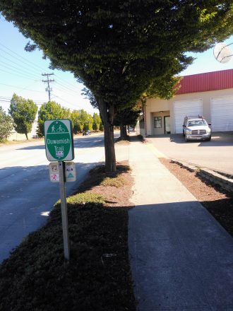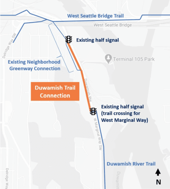
The Duwamish trail provides one of the only dedicated bike routes to and from the South Park neighborhood, which is currently dealing with an influx of drivers looking for any shortcut they can take to avoid the repercussions of the West Seattle bridge closure. But for nearly half a mile on its northern end, the Duwamish trail is nothing more than a narrow sidewalk through an industrial area. With the South Park to Georgetown trail moving forward, this segment deserves more attention than ever.
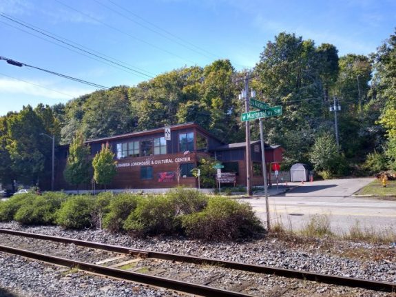
For years, the Duwamish tribe has been trying to improve safety in front of their Longhouse on West Marginal Way SW along the river that bears the name of the tribe. It took the West Seattle bridge crisis, which diverted thousands of vehicles per day onto Marginal Way that would have otherwise used the bridge, to provide impetus (and funding) to install a crosswalk and traffic signal directly at the Longhouse. “This year, we leveraged the fact that we have this crisis with the bridge closure to get the city to fully fund the project,” Councilmember Lisa Herbold recently told Real Change. Mitigation funds for the bridge will pay for a new pedestrian crossing directly in front of the Longhouse as well as install a missing sidewalk on the west side of Marginal Way north of the building.

In 2019, lacking funding for a pedestrian crossing, SDOT took southbound Marginal Way down from one lanes to two for a short stretch in front of the Longhouse. Now SDOT proposes to extend that southbound lane closure up to the northern end of the Duwamish trail, converting the curbside lane into a two-way protected bike lane.

This improvement is obviously not a complete replacement for an off-street trail, but would be an improvement, especially for people biking southbound in the direction of traffic. But the biggest benefit of this change would be the impact on the speed of drivers on this segment of Marginal. SDOT recently brought the speed limit on the street down from 40 mph to 30 mph. But consistent design changes would do more to lower speeds, and since drivers are already merging into one lane at the Longhouse, it makes sense to extend that change all the way north.

But the protected bike lane idea is meeting opposition from those who do not want to see auto capacity on Marginal Way reduced any further. Port Commissioner Peter Steinbrueck has been an outspoken critic of taking away space for vehicles on Marginal at West Seattle Bridge Community Taskforce meetings. In November of last year, the freight advisory board sent a letter to Deputy Mayor Shefali Ranganathan asking the city for West Marginal Way to be “restored as a five-lane facility”. The letter mischaracterizes the final connection of the Duwamish trail as “redundant” because users currently can use the sidewalk. “We are in deeply opposed to removing traffic lanes to add a protected bike lane on WMW”, the letter states. “We believe the proposed signal and sidewalk improvement near the Longhouse will improve safety so that the southbound traffic lane can be restored as a through traffic lane on this Major Truck Route.”
I spoke with Aley Thompson, who serves on the South Park Neighborhood Association and also serves on the West Seattle Bridge Community Taskforce. She told me that it was not her understanding that a removal of the lane reduction in front of the Longhouse was on the table, and cited the need to slow vehicle traffic down on Marginal as the most pressing issue.
SDOT spokesperson Ethan Bergerson characterized the issue as a debate over whether to install the protected bike lane this year or wait until the West Seattle bridge is repaired. “SDOT is committed to making this connection,” he told me. “Maintaining a single lane of traffic throughout the corridor would likely reduce the ‘hurry up and wait’ effect of congestion caused cars merging back into a single lane, and result in more consistent speeds throughout the corridor, closer to the current 30 mph speed limit,” Bergerson said, citing the lane reduction at the Longhouse as the “bottleneck” that is having a bigger impact on travel times than the bike lane would.
Asked if the lane reduction in front of the Duwamish tribe’s facility was on the table for removal, he told me, “There has not been a final decision on this. We are planning to conduct stakeholder engagement in early 2021 to get feedback once we have a design proposal ready to share.”
The new signal at the Longhouse is set to be installed this Summer. A pedestrian crossing will likely only be a bandaid if speed treatments aren’t effective, and adding the lane back to the street will likely increase driver speeds. It’s clear that any bike facility’s larger purpose would be to serve the larger goal of making West Marginal Way a safer street for everyone to use.


Comments
9 responses to “Proposed Duwamish Trail extension could make everyone safer on West Marginal Way”
Expect apoplectic, foaming-at-the-mouth opposition to this project from West Seattle drivers. You can see this in the comments on stories about the bridge closure and Longhouse lane reduction in the West Seattle Blog. Also expect drivers to use the center turn lane as a second southbound lane – this already happens approaching the Highland Way intersection.
As for controlling speeds, nothing is going to slow traffic short of speed humps or chicanes. Typical speeds are closer to 50 mph than 40. It is common for several cars to run the light at the pedestrian crossing. Vision Zero on this road is a big fat zero.
I commuted this way by bike pretty much daily for over a decade, including before there was any marked crossing and the “trail” simply disappeared. It was scary in general and occasionally very scary.
By my observations when driving, most people are still driving just above 40 mph, which while still likely to cause the death of any people walking or riding, is at least below what they were driving before the 30 mph speed limit. Before that, most drivers were going above 50.
We need to move people, but we need people to be able to move safely.
First, I just want to note that Ryan is doing a fantastic job with these blog posts. Keep up the good work!
Second, the reduced speed limits and digital signs have been quite effective. Average speed on the corridor has dropped considerably. Very few instances of 50-60 mph like what was common in the past. Plenty of 45-50 mph still.
Third, there’s no way in a million years I would ever ride northbound in that proposed bike lane facing traffic unless there is a physical barrier. Flex posts aren’t going to stop a head-on collision.
Finally, why is there not a protected bike lane connecting this corridor to Georgetown? It’s one of the most confounding missed connections in south Seattle. All that money spent on a bike bridge across 1st Ave that leads to a dead end. Why does Michigan St not have bike infrastructure?
You will probably be just as dead getting hit at 45-50 as you will at 50-60 mph. But a lane diet will only allow you to speed as fast as the most compliant driver.
Joe you are so right! I have made my way from Beacon to the Duwamish many times, but I am a very experienced spandex clad dude and even I am freaked out merging onto Michigan before the entrance to the freeway off 1st Ave. This is a terrible miss in the bike network.
“Finally, why is there not a protected bike lane connecting this corridor to Georgetown? It’s one of the most confounding missed connections in south Seattle.”
Boy, that’s a crowded field.
Here’s another nominee for most confounding missed connections — a connection between the Othello light rail station and the recently installed paint-and-post bike lane two blocks west that runs up, over, and along the west edge of south Beacon Hill on Othello – Myrtle – Swift. Or a connection to Georgetown on that same route, on the west side, instead of just sort of ending near the I-5 on-ramp. That entire new bike route just begins and ends sort of in the middle of two neighborhoods without truly connecting the route to anything. It’s great that it’s there, but the lack of connection removes its utility for many — you’re going to have to ride in scary traffic or on sidewalks crossing busy driveways if you want to ride from Beacon Hill or New Holly to anywhere beyond that route.
Another nominee — protected bike infrastructure connecting the Rainier Beach light rail station to the Rainier Valley North South Greenway, or even to the closer Chief Sealth trail. There was obviously no thought given to this at all.
Yes, excellent article, Ryan. The way West Marginal is now configured, it makes no sense to expand two 2 lanes just south of the WS Bridge, reduce to 1 lane before the Longhouse, and then expand again to 2 lanes south of the Longhouse. So installing a 2 way bike lane with jersey barriers would be a good use of that southbound lane. I hope SDOT is not seriously considering removing the one lane segment near the Longhouse after the Longhouse crossing signal is installed. I am afraid impatient drivers on a 5-lane “freeway” will be too tempted to risky behaviors around people crossing (they are already ignoring the existing signal farther north). Expanding to 2 lanes south of the Longhouse will provide drivers plenty of opportunity to lane jockey trying to get to the signal first in an area where there is little if any pedestrian and biker traffic. One mile of reduction to a single southbound lane is not going to be any great hardship Peter Steinbrueck and Freight Advisory Board, as long as you are willing to adhere to the speed limit.
Joe Z is right, we also need a lot of attention ASAP to the north end of the First Ave S. Bridge, but that is a more complicated problem with all the construction and complicated intersection to deal with.
Thank you for reporting on this, Ryan.
We have also been involved with supporting the Duwamish Tribe’s Ridge to River vision, and their desire for a safe crossing of West Marginal Way SW at or near the Duwamish Longhouse & Cultural Center. Traffic regularly exceeds 50 mph on West Marginal Way, with heavy trucks and some flat out drag racing . The Tribe welcomes with open arms all people to many public programs at the Longhouse and in the həʔapus Village Park on the river. There is broad community support from West Seattle, South Park and Georgetown community groups for this project. SDOT and City Council got on board with this before the WS bridge closure. The project ties into the Tribe’s ongoing project to create walking trails from the Longhouse up through the West Duwamish Greenbelt to South Seattle College, Pathfinder Elementary School and the Puget Ridge neighborhood. Lots of people are actually in close walking distance, but there is no hospitable way to get to the Longhouse now without driving, and there is little parking and no bus service.
The biggest benefit of the protected bike lanes would actually be to slow down vehicle speeds southbound on West Marginal Way SW. Median speeds are in the mid-40’s and did not come down after speed limits were lowered to 30. Now speed radar signs are up, resulting in only about a 5 mph reduction. There is no congestion problem southbound due to lane capacity. There is a speeding problem, causing crashes and making it treacherous to cross on foot. Traffic congestion only occurs at the south end at the Highland Park Way intersection, where the backup from the First Avenue South Bridge begins. Along most of WMW, crazed drivers are rushing to get into the traffic jam as fast as they can. By making more of it one lane, it will allow drivers who travel at or near the speed limit to control the speed of all traffic, without any effect on throughput across the bridges. The bridges are the choke points, not the street. Some industrial users want it slower, so they can get in and out of their driveways safely. Port of Seattle and Freight Advisory Board members are wary about losing a lane and on truck maneuvering at drives. We support the Port’s goals for good, efficient truck routes including on West Marginal Way SW. Our members and our neighbors are employed by these industries, and we all depend on them. But we think the concerns about the PBL are not justified. If it turns out we are wrong and they are right, it would be easily reversible. If it turns out we are right, this could help tame a free-for-all highway into an urban street that prioritizes freight for the industries and seaport, but safely accommodates bike and car traffic and pedestrians.
The screaming begins:
https://westseattleblog.com/2021/01/see-the-west-marginal-way-alternatives-that-headlined-west-seattle-transportation-coalitions-january-meeting-as-city-gets-ready-to-seek-feedback/#comments