Today we are circling back to some news that we missed from last autumn. SDOT has announced they will be making big upgrades to the Queen Anne approach of the Thomas Street overpass connection to Myrtle Edwards Park and the Elliott Bay Trail this year. This improvement comes as part of the package of transportation changes planned with the opening of Climate Pledge Arena this fall.
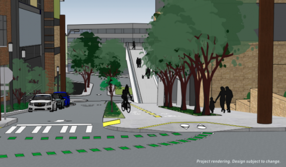
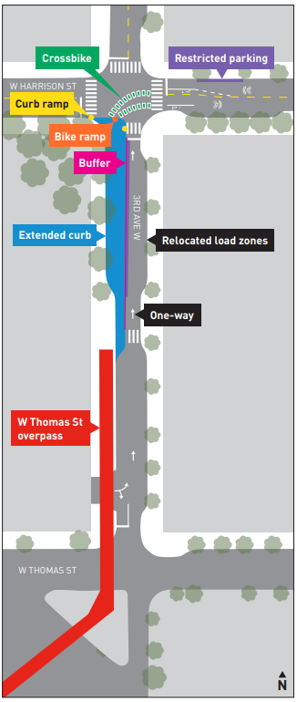
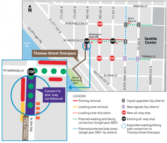
After public comments supported the option allocating the most space for walking and biking here, SDOT will convert the entire western half of 3rd Ave W north of the overpass to an extension of the trail, with delineated space for two directions of bike travel created out of one half of the current street, turning the street into a one-way for vehicle traffic northbound. This is how the street basically operates now anyway, with most traffic going west on Harrison instead of south on 3rd to access Elliott Ave.


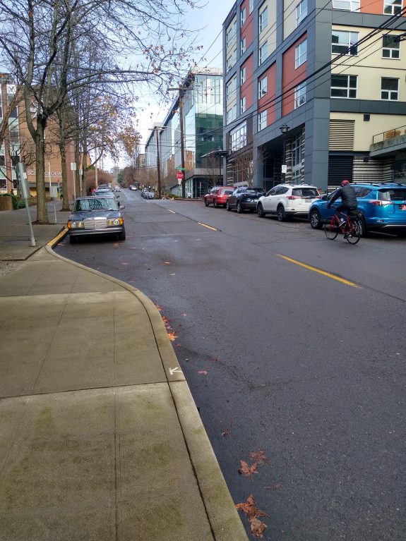
This will alleviate a big pinch point to a great connection- currently people biking over from the waterfront get to decide between biking on a sidewalk that’s not in great condition or taking the lane on 3rd Ave W, where drivers heading off of Elliott Ave frequently exceed the speed limit.

SDOT also announced they will be installing a protected bike lane on W Harrison Street which will connect to the planned two-way PBL on Queen Anne Avenue N, but only in the uphill eastbound direction. People biking westbound will be in a travel lane that SDOT will be adding speed cushions to. SDOT is also adding four new all-way stops in the area which should slow traffic as well.

SDOT had originally envisioned bike traffic using either Thomas or Republican Street to connect to the overpass, but Harrison makes much more sense given the street grades in the neighborhood.
The overpass connection is one spoke of the bike network improvements coming with the arena, the other main one being a connection with the 2nd Avenue protected bike lane via 1st Ave and Broad Street. Thomas Street on the other side of the Seattle Center was another improvement, but that has been put on hold. As for the disappointing news about the Denny Way terminus of the 2nd Ave PBL, we will be bringing you additional info about that soon.
And then there’s all of the infrastructure for private cars coming with the arena.
On the other side of Myrtle Edwards, any bike connection between the Elliott Bay Trail and the planned waterfront bike trail remains unfunded as the rest of the waterfront’s reconfiguration moves forward.
But the Thomas Street overpass spot improvements and the connecting one-way PBL are definitely something to look forward to this year.


Comments
9 responses to “Queen Anne approach to Thomas Street Overpass to dramatically improve”
Furthermore, regarding ” taking the lane on 3rd Ave W, where drivers heading off of Elliott Ave frequently exceed the speed limit”, it is a steep uphill from 3rd to Harrison, so cyclists are going slower, making the relative speed between motorized vehicle and bicycle even greater.
Another interesting question is how to connect from west of the Seattle Center to east of Aurora. I tend to control the lane on Mercer and then, if favorable lights, make a left turn as a car would to connect to the cycletrack. Folks less comfortable would need to wait through traffic lights to do a Dutch left on crosswalks. Clunky. Hopefully Thomas St Greenway will fix this?
Cut through the Center grounds or go north to Roy. Both better options than taking a lane on Mercer
A welcome upgrade! I occasionally use it eastbound, and it’s pretty goofy. Look forward to seeing this in place.
I work nearby and have always been baffled by the laziness of the northern connection to the Thomas Street Overpass. This is a welcome improvement.
That being said, SDOT really needs to repave Harrison Street if it’s going to be a major bicycle route. Currently the street is a mess of broken concrete west of Queen Anne and adding a stop sign at 2nd Ave W will make the descent even more of an adventure. The downhill side of 3rd Ave W is also pretty bad (uphill was repaved a few years ago and is fine). For what it’s worth, my WB morning commute is 5th Ave N>Seattle Center>Republican and I expect that will still be the case since cutting over to Harrison is just an additional complication. EB I always go up to Roy because the Seattle Center route becomes a tourist slalom in the afternoon. As long as nobody screws up those routes I promise not to complain.
Wow! Old cycling habits are hard to break! I thought Roy was still one way! I’ll have to try that next time; it would make transition to Mercer cycle track easier.
The westbound bike lane is frequently “I’m allowed to park here because I’m ‘just’ picking someone up” lane
This seems great, but every time I see North Seattle projects being prioritized while South Seattle ones are pushed out to… what was it from your latest update, 2023 at the soonest?
Ugh.
Anything south of the Ship Canal can hardly be considered “North Seattle”. Regardless, these improvements are funded from the North Downtown Mobility Action Program, essentially a pot of money from Oak View, and can’t be used on projects outside the vicinity of the arena, regardless of how anyone wants to spend the money
Hey Ryan! The neighborhood that the Thomas Street Bridge is in is called not Uptown (not QA). Happy to send you a map on the neighborhood. http://www.facebook.com/SeattleUptownAlliance
Thanks!