Later this year, the Seattle Department of Transportation is set to complete improvements that will make it easier to bike through one of Beacon Hill’s trickiest intersections. The changes planned at 15th Ave S and S Columbian Way come three years after the department was originally scheduled to implement a much bolder reconfiguration of the intersection here, but that iteration of the project was cancelled after local opposition.
SDOT is repaving a stretch of 15th Ave S, from Spokane to Angeline Streets. Most of the street here is two lanes in both directions without much street parking, and isn’t getting any additional space for bikes. This is unfortunate, as there’s plenty of room and no parking to fight over. Traffic volumes from SDOT’s last citywide volume report show similar vehicle volumes on 15th Ave S as on the segment of Rainier Ave S which has been converted to one lane in each direction with a center turn lane. It also has very similar volumes to S Spokane Street, also getting repaved here, which already has one lane in each direction with painted bike lanes.
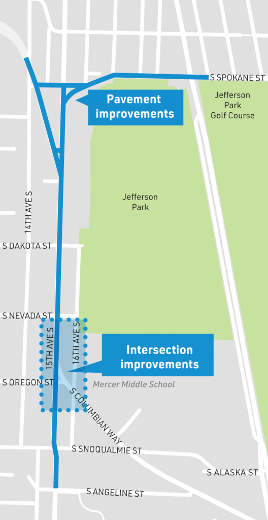
SDOT is currently planning an all-ages bike route across Beacon Hill for 2023, and currently plans to route people biking onto Beacon Ave in this area. But on the north end of the hill, advocates are pushing for the protected bike lane to be routed onto 15th Ave. At the south end of Beacon Hill, SDOT already installed bike facilities on Swift Ave, which is what 15th Ave turns into. 15th Ave will continue to make sense as a bike corridor and an opportunity was missed here.
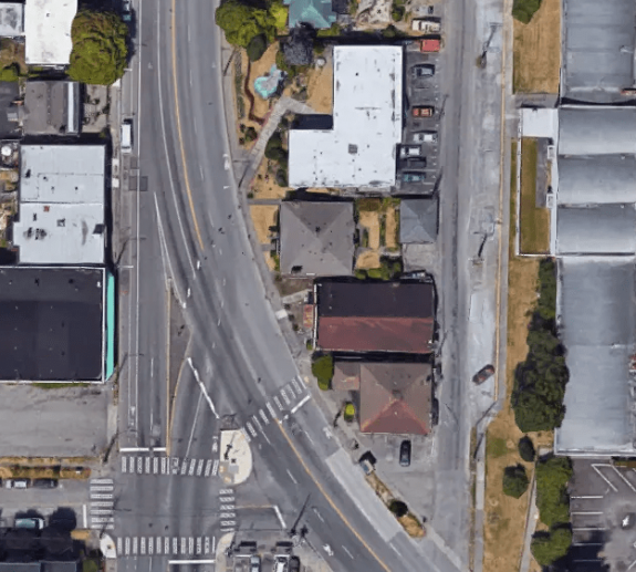
As for the improvements at 15th Ave and Columbian Way, the plan that would have been implemented in 2018 directed all southbound traffic onto the curve of Columbian Way, with drivers wanting to continue on 15th having to make a right turn. This would have dramatically reduced the size of the massive intersection. A second crosswalk across the intersection from the middle school was to be added. A public plaza would have been created out of the excess street space, with space for people biking to get through the intersection via the crosswalks.
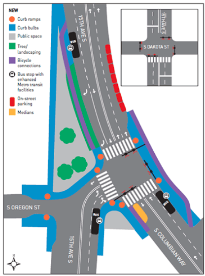
The design now planned maintains one through lane on southbound 15th Ave S, doesn’t add any additional pedestrian crossings, and doesn’t include any space for people biking northbound from Columbian Way. But it does add a protected bike lane on southbound 15th Ave S by moving the parking in this stretch next to the travel lane. That protected bike lane starts very slightly out of frame at the top of the following image.
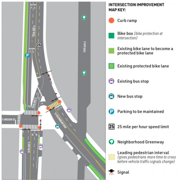
On the south side of Oregon on 15th Ave, people biking will share space at bus stops with people entering and exiting buses, matching similar designs seen recently on NE 65th Street and 12th Ave S. Southbound, the bike lane disappears very shortly after the bus stop, making its utility questionable. Northbound, the bike lane extends nearly two blocks down to S Angeline Street, the street where the Chief Sealth trail terminates. But at Oregon street, people riding northbound are dumped onto the sidewalk.
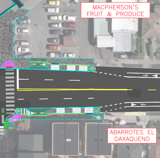
Though the original redesign here was approved in 2016, improvements at this intersection date to at least 2008, when a reconfiguration very similar to the one proposed was suggested in an SDOT commissioned study, the Southeast Transportation Study.
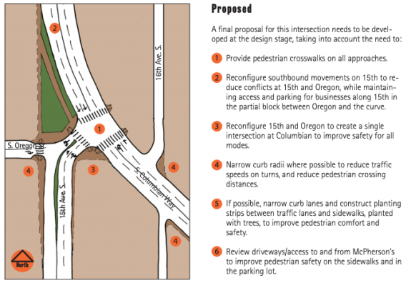
With the project going in now, after years of delay, with most of the changes proposed along the way discarded, is a testament to just how much of an uphill battle it is to redistribute essentially any current street space allocated to vehicles.
During the last full Seattle Public Schools school year (2018-2019), the southbound school zone speeding camera on 15th Ave S was the most active single camera in SDOT’s school camera arsenal. Over 800 tickets were issued on average per month during the course of the year, 8,012 in total, underlining just how much this intersection redesign is ultimately a school safety project. It’s also likely there would be zero changes happening here if not for the advocacy of groups like Beacon Hill Safe Streets, despite existing plans here on the books. The changes here are clearly hard-won, and should have an impact.
This weekend and next weekend, SDOT will be closing Columbian Way immediately south of 15th Ave S. Traffic will be detoured via Snoqualmie Street and 15th Ave S. You can read more about the planned improvements here.


Comments
9 responses to “After years of delay, improvements coming to 15th Ave S & S Columbian Way intersection”
Ugh :(
Wait, so… it’s going to be even more of a pain in the ass for bikes heading south on 15th to turn left towards Columbia now? PBL means bikes will need to exit the bike lane much earlier to merge with traffic, so woe to anyone who doesn’t know exactly when the upcoming intersection occurs, I guess?
I don’t know that the original 2018 proposal was much better for those heading in that direction either, though. I’d much rather a PBL start way further north, then end in time for cyclists to merge with traffic to turn. Maybe the volume of cyclists who continue south on 15th is much higher than those who want to turn though, I dunno.
Also not thrilled about bike lanes running into people entering and exiting buses… it’s only been a few weeks since that was finished on 12th and I’ve already had too many close encounters with pedestrians.
I’m glad the roads are being repaved at least, even if I wish it were all of 15th from south of Jose Rizal Park.
Yes after all this there will still be no decent way to get into the eastbound PBL on Columbian Way. Either traverse multiple bus stops on the sidewalk or brave the traffic.
To get onto eastbound Columbian Way, I’d continue south through this intersection and then cut over on Snoqualmie. But that’s probably not intuitive if you’re not familiar with the area. I preferred the more streamlined 2018 approach. With the current configuration, I’ve watched several cars try to make left hand turns to go south onto 15th (into oncoming traffic) when headed westbound on Columbian Way. I think this will continue to be an issue with the new design.
Yeah, it looks like the best course would be to use the crosswalk at Oregon or to turn left at Snoqualmie, after the PBL ends. Merging into traffic north of the 15th/Columbian intersection to continue onto Columbian will be tricky not only because of the PBL, but because drivers will doubtless be extra aggressive towards cyclists in traffic once there’s a PBL in place.
I think the intention is for bikes to turn at S Oregon St and use the crosswalk to navigate to S Columbian Way. Not a huge fan of this, would have preferred the 2018 plan.
Also not a fan of the current bus treatment. We’ve done this well in places like Dexter Ave N and Roosevelt Way NE. Too much conflict in this design. Though I don’t think it’s fair to judge the 12 Ave S implementation yet as it isn’t completely finished. Still needs markings and protection for the bike lane. Cars seem confused as well, I’ve seen some quick merges from cars traveling south on 12th towards the bridge. Changing 12th Ave from 2 lanes to 1 north of Weller is still pending.
Dexter and Roosevelt are very different. NE 65th is the best example of what this “Toronto-style” bus stop looks like right now.
I think you’re right that the 2018 plan would’ve cut down a lot of potential confusion.
And fair, a lot of the confusion that remains on 12th is due to there still be some construction occurring, and I suppose everyone hasn’t really had a chance to get used to the bike lane going into the bus area. My frustration has largely been with pedestrians who just don’t care to move out of the way of oncoming bikes, so you just have to full stop and wait for them to board a bus, or if you have enough lead time, merge into traffic and go around.
bus stops for routes 50, 60, and 107?