There’s a good chance you missed the news about this one because, well, let’s just look at the timestamp … oh no.
![]() As part of the Climate Pledge Arena transportation plan, SDOT closed a short section of the 2nd Ave bike lane to create an additional lane for cars leaving the arena parking garage. Because nothing says “climate pledge” like turning a bike lane into a car lane. People started mounting a campaign to reverse this decision in early 2020, but you all know what happened next. Amid lockdowns and everything else in 2020, everyone had more pressing matters to attend to and the half-block of bike lane removal just south of Denny Way went through. Now the bike lane is routed up onto the sidewalk. No additional sidewalk space was created. It’s not great.
As part of the Climate Pledge Arena transportation plan, SDOT closed a short section of the 2nd Ave bike lane to create an additional lane for cars leaving the arena parking garage. Because nothing says “climate pledge” like turning a bike lane into a car lane. People started mounting a campaign to reverse this decision in early 2020, but you all know what happened next. Amid lockdowns and everything else in 2020, everyone had more pressing matters to attend to and the half-block of bike lane removal just south of Denny Way went through. Now the bike lane is routed up onto the sidewalk. No additional sidewalk space was created. It’s not great.
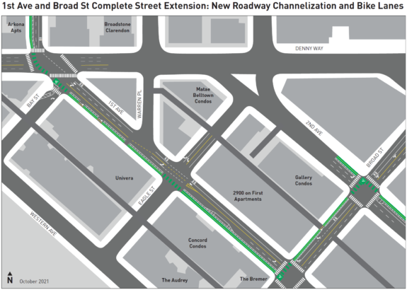
But OK, that’s all behind us. The city is beginning work this weekend on what they hope will be the primary bike route for people traveling between Belltown and Lower Queen Anne/Uptown. It does require a zig-zag, but it should be a big improvement for people accessing the business district rather than Seattle Center. This post does include feedback on the design, but we criticize out of love and because we care so much about this work. It is great that the city is building a connected bike route here, and this project required several blocks of on-street parking removal, which is rarely politically easy to do. Bike advocates have a habit of focusing on what needs to be improved rather than what has been accomplished, and that’s because the shortcomings are very important. But our city has never had a connected bike route to the Lower Queen Anne/Uptown business district before. This is a big deal.
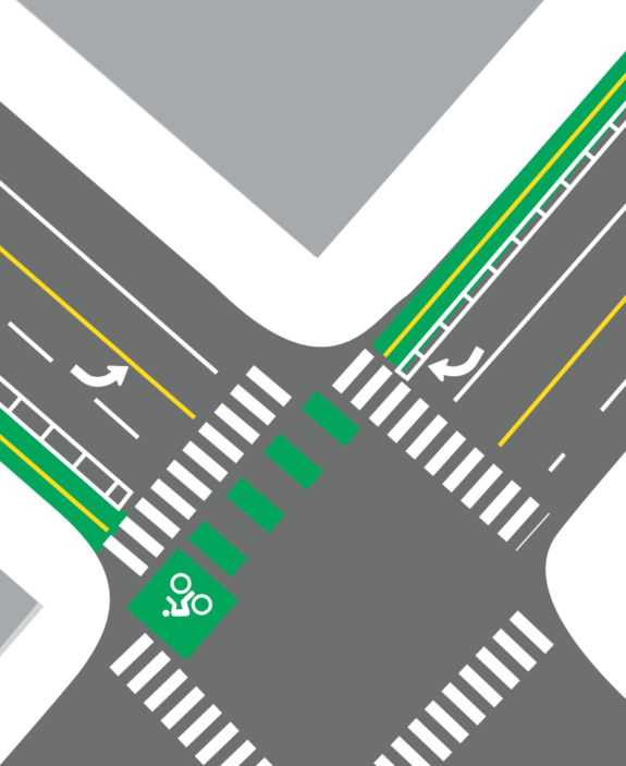
 Heading north in the existing two-way bike lane on 2nd Ave, people will need to make an awkward left turn into a new two-way bike lane on Broad Street between 2nd and 1st. I say awkward because the space to wait to turn left is sort of in the way of people going straight on 2nd. Seattle has still not figured out how to build a properly protected intersection that provides comfortable space for all users. I’m sure people will make it work, but this design will have a practical limit to how many people can use it at the same time without backing up into the road or bike lane space. Maybe that’s a problem for another day. We’ll see.

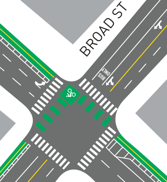
The intersection at 1st and Broad is similar to the intersection with 2nd, but flipped. We will need to pay close attention to how right turns from southbound 1st Ave to westbound Broad Street function with the bike box. This feels like a spot that may need some extra protection.
Then the new two-way bike lane on the west side of 1st Avenue will extend north for a couple blocks to Denny Way, where it meets up with a separate project up 1st Ave, west a block on Thomas Street, then north on Queen Anne Ave to Mercer Street.
It seems likely that a lot of people who are heading to Seattle Center will continue to take the direct route on 2nd Ave even though it is now routed onto the sidewalk. The connection into the park is just more obvious and direct. But the new bike lanes will likely be the best way to get to the Lower Queen Anne/Uptown business district and neighborhood.
The 1st Ave and Broad St Complete Street Extension Project will build bicycle and pedestrian improvements connecting Belltown to the Climate Pledge Arena and to the Uptown neighborhood, helping to fulfill the City’s Bicycle Master Plan vision to make riding a bike an integral part of daily life in Seattle.
In coordination with the opening of the Climate Pledge Arena in 2021, this project will construct two-way protected bike lanes along Broad St between 2nd Ave and 1st Ave, and along 1st Ave between Broad St and Denny Way. This project will connect the new Climate Pledge Arena with the existing protected bike lane along 2nd Ave, which will continue to provide additional access to the Seattle Center campus at 2nd Avenue and Denny Way. This project will also connect to the 1st Ave N and Queen Anne Ave N protected bike lanes, partially completing the bike network between Belltown and Uptown neighborhoods.
This project is identified and funded by the North Downtown Mobility Action Program (NODO MAP).


Comments
7 responses to “SDOT starts work on bike connection from Belltown to Lower Queen Anne/Uptown”
I do hope SDOT will continue its practice of rapid refinement and revision of built projects to improve safety and convenience: watch how it works when you’re ’done’, then make it better quickly.
What isn’t shown in this drawing is what happens further north. The bike lanes switch to QA Ave, with a two way on the east side of the street. So, how does SDOT plan to connect to that ? Another jog ?
And further, they didn’t bother to connect that to the roy street bike lanes. Seems like really poor planning.
I’m getting really sick of SDOT’s piecemeal approach. I’m not sure that the infrastructure they are building is any better than nothing. If it is too inconvenient to use, will people use it ?
It isn’t just the jogs but also the protect left (or right) turns which reduce the amount of green time to get through an intersection. When you add all the inconveniences together, you might not be going any faster than a pedestrian.
The connection further north is already done. Thomas between QA Ave N & 1st Ave N became one way eastbound and there is a one-way PBL on both sides of the street. From there it transitions to a 2-way PBL on the east side of QA Ave N.
Actually, poor armchair quarterbacking. It does connect to the Roy Street gutter lanes via Queen Anne Ave N. Few people use it though; I see more cyclists on Mercer now than I did a year ago.
This is wrong! There is no bike connection from QA Ave at Mercer where bike facility ends to Roy! I don’t know what you mean by “gutter lane”. SDOT built a pathetic short little “merge” lane for bikes, maybe 20 yards long on the far side of the Mercer/QA intersection. Like you are going to rev your bike up to 25 or 30 mph and just jump into the traffic lane on N. Bound QA Ave. A block ahead, if you want to go west instead of east on Roy – good luck with that. About the only thing you can do is an unstructured Copenhagen left by pulling in at Counterbalance Park and then waiting to ride west across QA Ave, in the pedestrian x-walk, then jog onto Roy. No signage or cues for that. It is a very dangerous, offset intersection. I was at the City’s Bike Advisory Council meeting when this project was presented and discussed and SDOT staff actually apologized for how bad it was. Another SDOT project that just ends wherever, dumping bikes out in a potentially dangerous location without any further direction or facility. The genesis for this whole project was getting bikes off of a much safer/better bike lane on 1st Ave. N. (now removed) so motor vehicle traffic would have easier access to the Arena.
What about westbound down Broad to the waterfront and the cycle path through the park everyone uses?
Second north of Denny isn’t popular with bikes because it’s a steep hill. I live next door on the Belltown side and don’t see many bikes there.
One huge win is the now-legal Denny crossing on the west side of First. Suddenly a PITA intersection is pretty simple for pedestrians and bikes to cross (there was an operational pedestrian signal yesterday when I walked by on the other side).
Biking down Broad to the park isn’t great. I’m torn however…uphill a bike lane would be nice, but downhill I actually just take a lane or use the margin. You tend to go pretty fast, and being in a little channel might be unsafe.
Why can’t y’all figure out protected intersections. Seriously, it’s embarrassing.