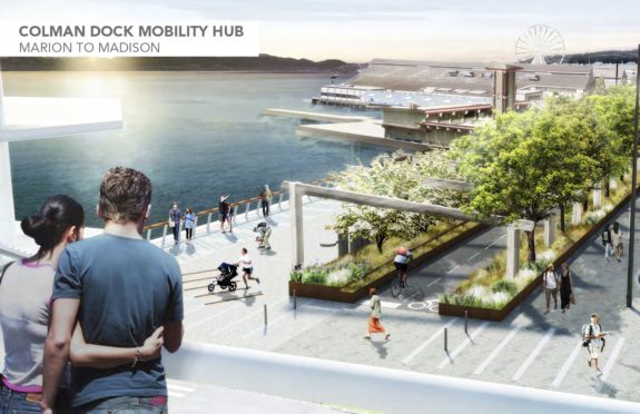
Seattle’s downtown waterfront has been under construction for so long, it’s sometimes easy to forget that when the dust finally settles there will be a complete waterfront bikeway for the first time in Seattle history. Upon opening, this bikeway will surely become an icon of the city, the setting for countless photos showcasing our beautiful city. In 2024, it should be possible to bike from Pioneer Square to the Burke-Gilman Trail entirely along flat, separated bike lanes and trails. By 2025, this continuous connection will extend all the way to Alki and South Park.
This is the most important bike route under construction in Seattle, and we must do it right. But the high-budget Waterfront Seattle project ends north of Pike Place Market, leaving a nine-block gap between the flashy new bikeway and the existing Elliott Bay Trail in Myrtle Edwards Park.

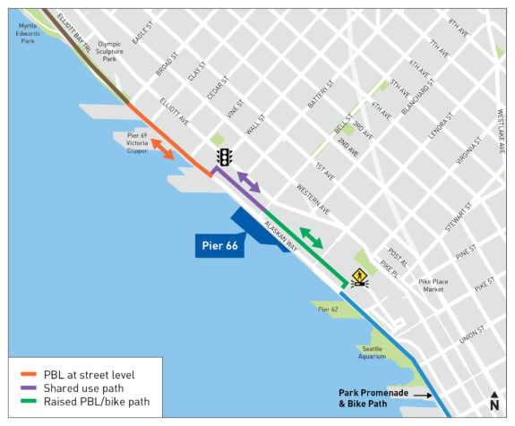
SDOT is currently designing a redesign of Alaskan Way through Belltown that will include a bike connection, but the current design concept bafflingly switches sides of the street twice within a span of six blocks. They are hosting an online open house about the project 4:30 p.m. Tuesday on MS Teams, which is a great opportunity to comment. Seattle Neighborhood Greenways also has a handy online form you can use to send a letter to elected officials.
Here’s the current SDOT design:


 “This design is inconvenient and confusing,” wrote Seattle Neighborhood Greenways in a blog post. “A lot of people likely won’t use it and will end up in the street or on the sidewalk, causing additional chaos and danger for both pedestrians and people on bikes — especially with the tens of thousands of tourists who use our waterfront trail each year.”
The zigzag is an attempt to “support sailing operations at Pier 66 and 69,” according to SDOT’s project page. And the cruise terminal does get busy during loading and unloading. But those loading times are fairly rare and very seasonal. It does not make sense to create a 24/7/365 bike lane detour to accommodate an intermittent use. “Pier 66 has heavy use for just 2 months in the summer, and tapering off in the shoulder seasons,” wrote Greenways. “Ask SDOT to work with the Port to find a solution that allows them to have safe loading and unloading, while maintaining a direct and efficient bike route.”
If the city were going to build this bike route along the east side of the street, they needed to make the part of the Waterfront Seattle design years ago. But with the waterfront design already under construction, the decisions to route the path along the west side of the street is set in stone. There is plenty of road space on Alaskan Way to work with here. I believe SDOT’s capable staff are able to find a solution that works well for everyone.
It’s hard to fathom how the engineering wizards at @seattledot can’t find room for a continuous bike lane here. pic.twitter.com/iG8ubjyj2T
— Qagggy! (@Qagggy) April 19, 2022


Comments
10 responses to “Tuesday: Tell SDOT we need a continuous waterfront bikeway”
“but the current design concept bafflingly switches sides of the street twice within a span of six blocks”
Woah! Do they really think cyclists will want to wait for traffic lights to switch sides of the street twice in the course of six blocks? That’s insanity! Practically cyclists will choose instead to ride with traffic and face the ire of motorists wondering why they aren’t using the infamous and misleading “$10M/mile infra”.
I’ve lost faith in SDOT. They did a good job on the Dexter bike lane. I can actually ride it at 25mph downhill and feel like I have room to react – because the sightlines are very good.
Not true with southbound on Greenwood N. Not true with parts of the relatively new Union bikelanes.
And the jogs across the street ? Who wants to wait for extra green signals ? It feels like SDOT forgets that bikes are often used for transportation and the routes aren’t intended to be mazes.
Am I over reacting ? Is SDOT really doing a good job of balancing priorities and respecting budgets ? Or are they simply fitting in bike lanes after everything else is pretty much finalized.
Bikes are slow. Building infrastructure that makes them slower just leads to people finding commonsense ways around the bottlenecks. It’s cars that need to be slowed down, not bikes.
This design is completely nuts. Most users, including myself, would simply end up on the sidewalk or street for 6 blocks. Only when the sidewalk and street are both jam-packed (rare) would I actually do the detour.
The idea that cruise ship passengers cannot wheel suitcases across a bikeway that will see maybe 1-2 users per minute is rediculous.
yes, nuts. I moved to Ballard in 1991; I have been a bike commuter ever using Alaskan Way without designated infrastructure. please do not make it worse. when the cruise ships are loading, all modes move like molasses. shared use pathways will be clogged in peak season.
This is ridiculous. And frankly, embarrassing. If this were any other mode the department that designed it would recognize and fix it before the draft was published. Could you imagine cars, peds or transit tolerating this nonsense?!
Try again, SDOT. Respect bikes as a mode of transportation and design/build infrastructure accordingly. Sheesh!
Am I the only one who likes the new design? I think it is a suitable testament to the innovative design skills of SDOT. It’s important to keep cyclists on their toes
SDOT expects the north part of Alaskan Way to have little traffic. The Elliott Avenue connector will take the volume. This concept reduces the north part of Alaskan Way to three lanes from four north of Virginia Street.
Let’s make this a real waterfront promenade that Seattle can be proud of. Close the roadway down to cars entirely. Permitted delivery trucks only during specified times. Bikes, scooters, and pedestrians always. Waterfront trolleys and buses to and from light rail, 3rd Ave buses, and Pike Place Market. That is what Seattle’s waterfront should look like!
Couldn’t agree more!