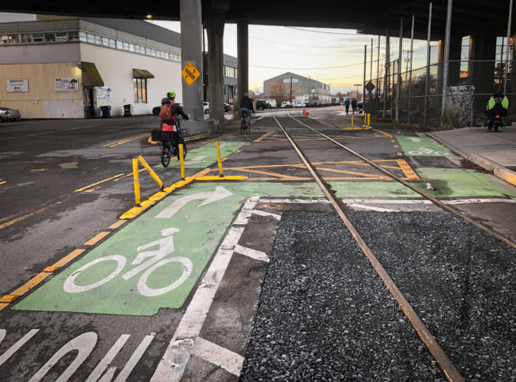
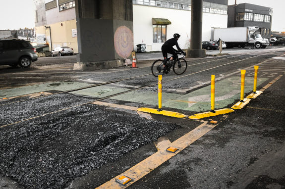
 SDOT completed work on an “interim” redesign of the problematic track crossing under the Ballard Bridge for people attempting to bike the Missing Link of the Burke-Gilman Trail, but the new gravel pits sporadically placed in the area seems to be baffling riders rather than helping them.
People have been crashing on the train tracks consistently for decades as they try to navigate through industrial Ballard after the abrupt end of the Burke-Gilman Trail, and a group of eight injured riders filed a lawsuit against the city last year (full disclosure: Washington Bike Law advertises on Seattle Bike Blog but had no input into this reporting). There are many hazards in the Missing Link area, but the tracks under the Ballard Bridge are the worst. Many people have been seriously injured — left with everything from broken bones to head injuries — after crashing while trying to cross the tracks, which have wide and uneven gaps on either side of them that can surprise riders by grabbing their tires or otherwise knocking them off-balance.
The safest way to cross the tracks is to move across head-on at a right angle rather than trying to merge across them, and SDOT has redesigned the marked biking paths several times in an effort to encourage right angle crossings. The problem is that the designed turn is too sharp, so people cut the corners to make it more comfortable. So the department’s short-term solution was to … dig gravel pits?
The idea was to “make the correct route more apparent,” according to an SDOT spokesperson (see full statement below). Since people kept crossing at shallow angles within unevenly paved areas rather than follow the designated bike routing, the department’s hope was that the gravel would deter people from riding through those areas. But it didn’t work.
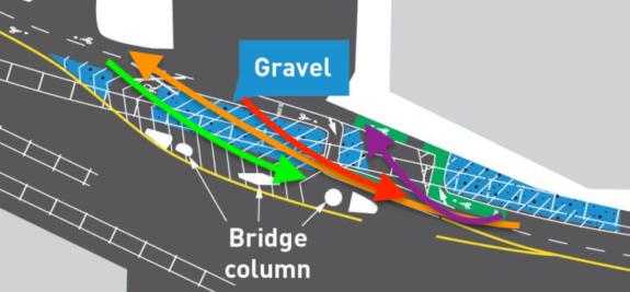
 I observed people using the new routing for about 20 minutes on a surprise sunny day Tuesday, and a majority of riders in both directions ended up in the new gravel pits. I would estimate that only about 1 in 5 riders followed SDOT’s designed route, and at least one of them seemed unsteady while making the sharp and slow turns necessary to stay within the lines. There was no clear consensus on the best route through the area, and I saw people do all kinds of things. I sketched out a few of the more common choices on this SDOT diagram showing the interim design concept:
 As you can see, only the purple route avoided the gravel (this is also my suggested alternative in either direction if you can’t make the city’s sharp turns). Everyone else ended up riding through at least a little gravel, and a surprising number of people rode significant distances through the middle of the pit. I suspect this is the route they were used to riding before the gravel pits were dug out. I talked to several riders and asked them what they thought of the gravel, and they all absolutely hated it. Words were not minced.
There are several deep ruts in the gravel, with is rather loose with medium-sized rocks. It is not the bike-friendly, hard-packed gravel you might find on a bike trail like the Cross-Kirkland Corridor Trail. You can see the paths some riders have already taken in the photos above, and some of the deep ruts suggest it didn’t go well for them. I am concerned that someone might assume the gravel is made to be biked on and then will be surprised to find that it is loose and dangerous.
The other issue is that gravel will not stay in the pits. There were many medium-sized rocks spread out on the pavement, which is yet another challenge for people just trying to get through the area. Either SDOT or some very kind (and probably frustrated) neighbor will need to sweep the gravel off the bike paths regularly.
One possible benefit of the gravel around the tracks is that it has raised the riding surface up closer to the level of the rails, which could maybe reduce the risk of crashing on the tracks. But gravel moves, and we don’t know what conditions will be like once the hobby train goes through.
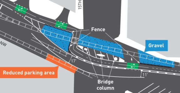
The good news is that phase 2 of this project does seem to have a much better design with wider and more realistic turns. This design involves rerouting the general traffic lane so that the bike routes can go around the bridge support pillars, and there will be fencing to deter people from biking through the gravel. Though it isn’t clear why the gravel was even needed if the plan is to fence the area off anyway.
 There is no solid timeline for phase 2 other than “in 2023,” but perhaps the poor results from phase 1 will expedite phase 2 into the “as soon as possible” column in SDOT’s work plan. UPDATE: I pressed SDOT for a more specific timeline, and they wrote: “We have not scheduled this work yet. We will likely schedule this in the near term, but the exact date will depend on weather conditions, crew availability, and if other unexpected high-priority safety needs arise (for example, emergency bridge closures and resulting bike detour implementation and management).”
The awkward phase 1 period also point to another issue: There was little to no public outreach about this change before it was constructed. Seattle Bike Blog did not learn of it until we received the construction notice in December. I’m not saying it should have gone through a huge and elaborate public process, but even a short online survey or consulting with the Bicycle Advisory Board would likely have returned some helpful advice about the use of gravel here.
Of course, this will all be moot if the city manages to finally clear all the legal hurdles and build the long-awaited Burke-Gilman Trail, which will bypass this area entirely by traveling along the south side of the street away from the tracks.
Below is SDOT’s response when I asked if there were any plans to address some of the issues described in this post:
We are not done with the project, what you see today is the interim condition. As a first step, we replaced some of the pavement next to the bicycle lanes with gravel in order to make the correct route more apparent. But we will be returning later this year to make the route easier to navigate for people on bikes by changing the layout of the bike lanes and road.
This will include realigning the bicycle lanes to the south of the bridge support columns. This will be a more comfortable and intuitive layout for people riding bikes, guiding them to cross the train tracks at a safe angle. The eastbound general traffic lane of Shilshole Ave NW will shift south for a short distance under the bridge to make room for the bike lane realignment. About 5 on-street parking spaces will be removed to accommodate the new bike lane design. Nearby businesses are aware of the pending changes to the right of way.
The two graphics in this blog post illustrate the difference. The top image shows the current layout, and the bottom image shows the future layout.
We will also add new fencing along the train tracks and new overhead lighting under the bridge.


Comments
22 responses to “SDOT’s new gravel pits under the Ballard Bridge baffle riders, more changes coming ‘in 2023’”
Perhaps, as an extremely short-term improvement, they could send a worker out with a manual sprayer and paint the gravel in traffic yellow so that it clearly doesn’t look like a place to ride?
That would help, I think. In daylight it’s clear that the gravel is gravel, but at night it’s indistinguishable from pavement until it’s too late.
LOL called it. Surface hazards you can’t see are surface hazards you’re gonna hit. Glad I read the story here before it happened……
Sometimes national/international urbanist/transit/bike people wonder why Seattle is so overrepresented in online conversations. One of the sneaky reasons IMO is that following The Discourse online is necessary to be a basic user of our bike network and transit system.
“So the department’s short-term solution was to … dig gravel pits?”
The molten lava pits didn’t fit in the budget.
Seriously though, the final layout looks like the best solution possible given the constraints short of building the Missing Link, but this interim step looks worse than before. SDOT should’ve waited until they could implement the entire new design.
Molten lava is pricy, but surely the City can afford shards of broken glass … I mean if they really want to discourage us from riding there.
What if we build a sweet jump over the tracks?
Interesting idea. It would result in a similar number of injuries, but at least they would be more fun.
I don’t understand why they are designing such small radius turns. Looking at the phase 2 plan, there appears top be room for 5′ inner radius on both sides. A larger radius would mean less probability of an accident.
Also, why cross at exactly 90 degrees ? I don’t know what the minimum safe angle is, but surely 75 degrees would still be safe. With that change the radius could be increased even more. They could make this a pleasant section to ride through.
Anyone care to explain this ? Thanks.
Yeah, I cross the tracks at 43rd/8th at maybe 45 degrees pretty routinely. I’m riding 2″ tires and I know what I’m doing … but really, knowing what you’re doing is the whole thing. You can easily cross at 45, even on road tires, if you know where the tracks are and can coast straight across. But you can easily crash at a 90-degree crossing if you’re accelerating, braking, turning, or leaning.
One thing I really don’t like is what the dudes in the photo on this post are doing. They’re just cruisin’ along the wrong way down the left side … so what happens when someone is coming the other direction, gets through their first 90-degree turn, looks up, and sees a fast, heavy electric cargo bike headed right into their path? Maybe hit the brakes? Maybe swerve a little? For a split second they might stop focusing on the one thing you have to do on a slick surface: coasting smoothly.
A couple weekends ago I went down on some slick leaves on the Ravenna Ave left-side bike lane. I ordinarily would have got across the leaves fine but I was in a merge zone and a car pulled out from a parking space ahead and to my right so I instinctually grabbed the brakes to stay behind in case they were going to make a break for the left-turn lanes (ya know, being defensive like my mom taught me). That was all it took — brake pad friction went static, tire friction went dynamic, my ass went to the pavement. Something like that is going to happen to some eastbound rider that gets surprised by westbound riders blowing off the crossing.
One of the ways that I “know what I’m doing” with crossing tracks is that I try to have an idea of what’s around me before I cross so I can coast across without getting surprised halfway and having to maneuver. But … even being pretty experienced with tracks I think I could end up getting surprised by oncoming riders here, or getting confused about which side they intend to get past me on, and end up off-balance with my wheel on a wet rail. Even if we know how to cross tracks we owe each other better than to barrel down the trail on the wrong side.
What if we didn’t have a god damn useless railroad crisscrossing a perfectly useful bike lane there? How many times do I need to wait, and assist / provide care for cyclists unfortunate enough to catch a wheel? (And Thank You to SFD each time you arrive!)
They need to stop with these ridiculous solutions, place rubber-filled flangeway in the tracks and take out the gravel that makes it into an obstacle course.
Not only can you fall if you were to accidentally ride into the gravel pits, but the rocks are going to loosen and go into the bike lane, which can also cause you to fall. Whose brilliant idea was this?!? This is actually WORSE than the original design. Honestly, the phase two looks awful, as well. Are these guys from SDOT actually trying to make 90 degree turns while cyclists are coming from the opposite direction also making 90 degree turns. I would like these engineers to bring their bikes and show us a demo so we can be entertained by the circus clowns crashing into each other. Everyone is much better off going at a 75 degree turn and not having to maneuver rocks and cyclists in the opposing direction.
Absolutely agree !
And, regarding the rubber filler, this is a location where that might make sense. I’ve read that the filler gets pushed down by train wheels repeatedly going over it. But, here, the wear frequency is almost non existent.
Not a fan of design phase 1 or 2, as each of them requires an unnecessarily hard angle and will cause unconfident riders more difficulty than if they were able to simply choose a gentler angle. Adding some pavement on top of the previous pavement to raise the trail to the height of the tracks would be helpful, and then allow folks to choose their angle, within reasonable parameters. I find 45 degrees to be fine so long as you aren’t placing lateral force on your tire via braking/leaning/etc. Others might do better with 60+ degrees. So SDOT could relax a little on the fencing and gravel on the western end of the design by moving it back a few feet. This would widen the entire path through the turn, but still force riders to maintain a reasonably “correct route.”
Washington Bike Law recently settled multiple claim for people who crashed in the Missing Link and part of that settlement includes Seattle’s agreement to make specific improvements in this area that should make it safer for everyone.
You are now seeing Phase One. I share Tom’s concerns about the gravel, but that’s how SDOT wanted to do it and our agreement requires the City to complete Phase Two no later than February 1, 2023 which includes fencing and I am hopeful that this will be better. Our agreement also includes a requirement that Phase Three will be completed by the end of 2023 which should be better still.
Ultimately, we want to see the Burke-Gilman Trail completed, but until then, it needs to be made safer. This is the first step.
LMAO. SDOT must have a cyclocross racer on staff. We have a sweet gravel sector now. Fences/barriers are next. Just add some muddy off camber turns and we have UCI compliant course. Bring it. I think this is the actual definition of chicanery, but its okay, it sounds like fun to me.
How is it possible that this gravel – which isn’t clearly delineated in anyway – is considered a safe option in any phase? Thanks for what you have done to push for this to be safer but I fear that these gravel pits are just going to be giving Washington Bike Law more business!
One of our lawyers just rode through this and questions whether what was done is consistent with Phase One plans. Whether or not it is, ideally SDOT will quickly move to Phase Two and Three.
What is the phase 3 plan ?
The gravel pits are ridiculous. Who thinks this stuff up? Seriously. Black gravel on a blacktop, just adjacent to the crossing areas. Brilliant! I hit that crossing at 6am last Monday. In the dark and rain the gravel pits were indistinguishable from the road. I usually cross the tracks at less than 90 degrees so I don’t have to slow down too much (not recommended) and my back tire skidded out when it hit the gravel. I stopped to see what the heck happened and stood there dumbfounded that someone would think this was a good idea. I seriously thought this was the handiwork of the salmon Bay gravel dudes who do everything in their power to thwart the safety of bike commuters. When I rode back through at the end of the day, there was gravel covering the crossing lanes, presumably from every other unsuspecting cyclist who skidded out. Whoever dreamed this up needs to have their head examined and fix it before the rest of do.
A bike friend points out that they didn’t even cut the path symmetrically — it looks like they accidentally cut the east side between the rails narrower than everywhere else.
Alternate suggestions I’ve heard: just take 46th (especially westbound); just take the car-sized lane (eastbound); avoid the sewer construction by cutting through the Fred Meyer parking lot to 43rd or 42nd.
Oh, and to be clear I’m a different Conrad than the other commenter here — small world!