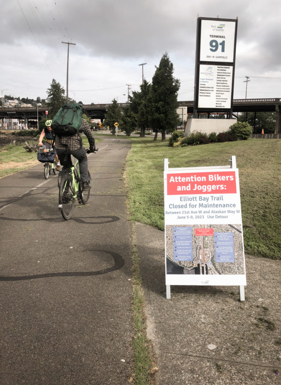
One of Seattle’s most unique bike routes threads a path through the middle of the Interbay rail yard, at times squeezed just a few feet and a chain link fence away from rail lines. In terms of width, condition and amenities, this section of the Elliott Bay Trail is far from Seattle’s best bike route. But the fact that it exists at all is somewhat amazing.
The Port of Seattle, which operates the trail, is making some much-needed repairs to the bumpy trail surface June 5–9, and there is no room in this constrained trail corridor for users to squeeze by the work zone.
UPDATE: The Port wrote in an email to Seattle Bike Blog that a favorable weather forecast means they hope to limit the closure to 20 hours starting early June 7.
That means trail users will need to detour from a trail that has no good detour options. The Port has posted signs outlining their detour plan, so I gave it a test ride.
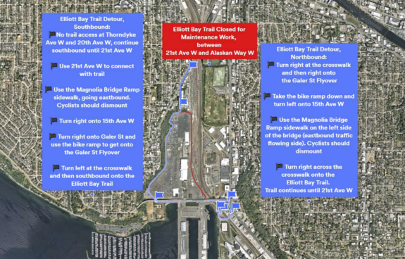
Without any additional signage, these instructions are both confusing and missing very important details, especially heading northbound. Hopefully the Port will install step-by-step detour signs. I followed the instructions heading northbound, turning right at the crosswalk and right at the Galer Street Flyover, which put me here:
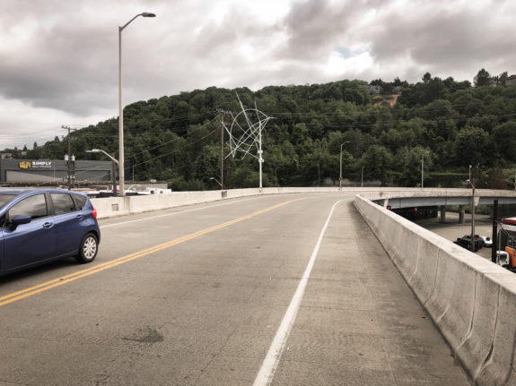
This is not where you want to be and has no access to the rest of the detour route. Instead, this bridge will lead you to a gigantically-overbuilt intersection on the wrong side of 15th Ave W:
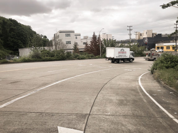
Instead, what you need to do is use the crosswalk to access the sidewalk on the far side of this ramp entrance. Turn right, and follow the sidewalk around the bend leading to the flyover bridge’s north sidewalk:
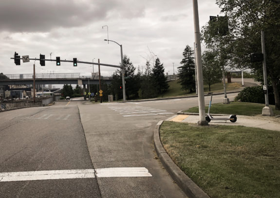
That sidewalk leads to a ramp structure that zig-zags down to street level. It is not a great user experience to bike down this, but it works.
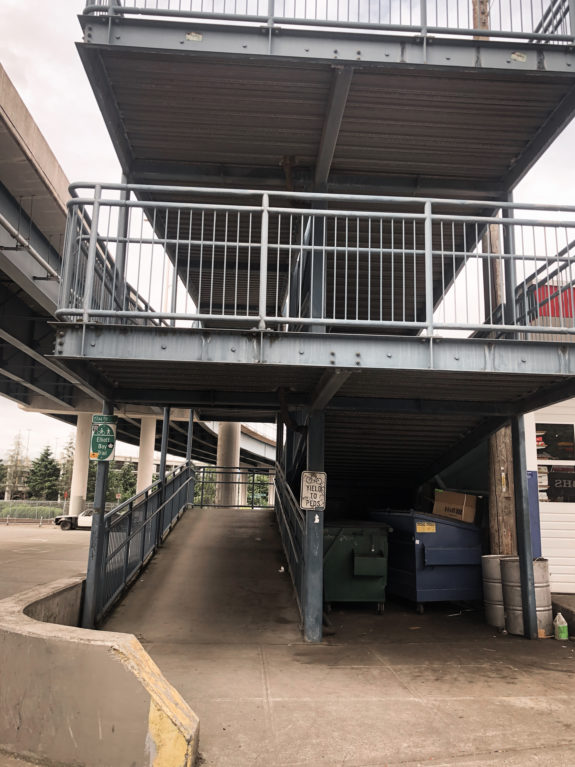
The detour sign then simply says to turn left onto 15th Ave W. It does not specify whether you are supposed to use the sidewalk or the roadway. Unfortunately, neither option is good here. The road is very wide and very fast, and it’s a little odd to try to turn left from the turn lane onto the Magnolia Bridge’s south sidewalk. I would suggest using the sidewalk instead, though it has some significant issues, too. It’s only a block, but you’d be surprised how many intrusive telephone poles Seattle is capable of installing in just one block of sidewalk:
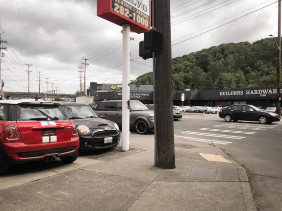
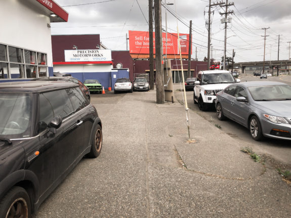
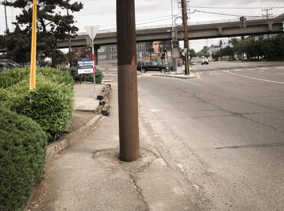
That last one…yikes. I don’t think that meets accessibility standards.
But once you successfully navigate around the poles, you have made it to the Magnolia Bridge. Congratulations? The detour sign says to dismount and walk your bike for this half-mile of skinny sidewalk with no barrier. Oh, and this one sidewalk is supposed to carry all trail users headed in both directions.
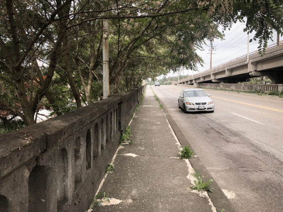
But at least trail users don’t need to deal with any more poles in the middle of the…oh, nevermind:
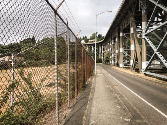
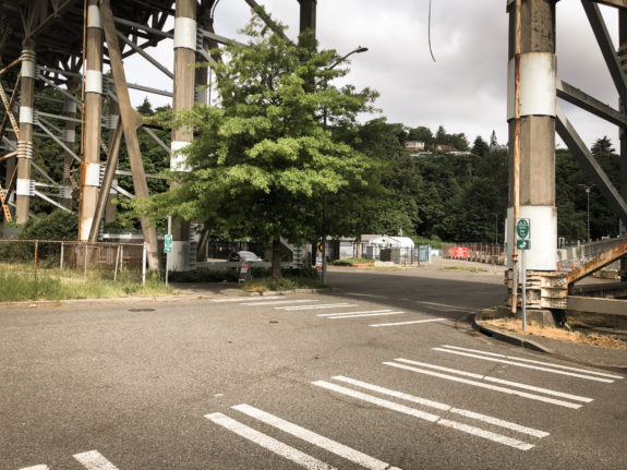
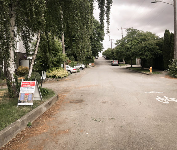
But once users are finally off the Magnolia Bridge, they are greeted with this bike route sign an a wonderful little trail that most of you had no idea existed. So it was a bit frustrating to get here, but at least you discovered something new.
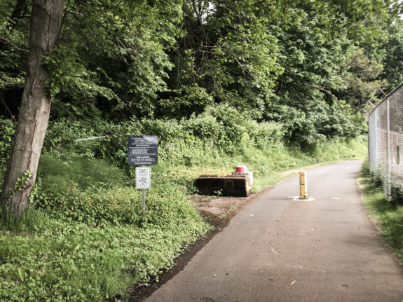
This lovely trail connected to 21st Ave W, a low-traffic street that meets up with Thorndyke Ave W and the rest of the regular bike network.
How to make it better
If using the Magnolia Bridge sidewalk really is the detour option they must use, then step-by-step signage will be vital. Additionally, the Port and SDOT could make the 15th Ave W section much better by creating a short temporary trail where the on-street parking is located between Galer Street and the Magnolia Bridge. They could even remove the illegal cement eco blocks nearby to offset that parking loss if they wanted to.
The Port and SDOT should also look into creating temporary space on the Magnolia Bridge for the trail detour. It is not a busy bridge, but people often go fast there. Even just coning off enough space for one-way trail users would free up space on the existing sidewalk for people heading in the other direction. There’s a lot to work with, and squeezing everyone onto that one sidewalk just isn’t a sufficient plan. Also, asking people to walk their bikes for a half mile is not a realistic detour direction.
But why are we using the Magnolia Bridge at all? There is plenty of space on the ground level to connect over to the trail portion of the detour. Terminal 91 already has walking paths through its sprawling parking area, so coning off a temporary path would not be difficult. The Port and Coast Guard do have extra security guarding the entrances to Terminal 91. But I’ve biked through here before back when Cascade Bicycle Club held their Bike Expo at the cruise terminal, and I don’t remember needing to stop at a security booth on the way (perhaps I’m forgetting?). I have asked the Port about why an on-ground detour wasn’t considered and will update this post with any response I receive.
UPDATE: A Port spokesperson replied, “Terminal 91 is a working facility with no sidewalks or bike lanes. It is not safe to detour through a working terminal. We are taking feedback on this detour seriously and are raising it with the local transportation agency. We agree there should be a better back-up solution for the future.”
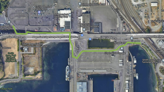
Another option would be to create a temporary trail on 15th Ave W and W Dravus Street, though that is much more extensive and complicated than our previous suggestions.
This detour is only for a couple days and is for a good reason: Improving the trail. But a closure like this highlights how horribly unfriendly Interbay is to people walking and biking. I still believe 15th Ave W should have permanent bike lanes because it serves many destinations that the trail does not. This street does not need to be this way. Especially with light rail on the horizon, Seattle needs to start thinking of this street as more than a highway for people driving through. Repaving some trail bumps nearby shouldn’t trigger such a massive headache. There is plenty of space for every person to feel safe and comfortable in Interbay while still supporting industrial and maritime jobs.


Comments
15 responses to “Alert 6/5-9: Port is repairing Interbay Trail bumps + Planned detour has very tight squeezes – UPDATED”
I am going to film a video guide for this later today (hope to finish it by Saturday), but basically I agree with all of your points. Considering what was done for the Spokane St Bridge detour, I think it is entirely possible to have a safer, easy-to-follow route for future trail closures. Let’s see if the Port actually follows up on this.
While filming on the detour route, I brought a tape measurer, stopped, and measured the width of the Magnolia Bridge sidewalk; at its narrowest, it’s 5 feet 9 inches wide.
However, the worst part of the Port of Seattle’s detour route is the west sidewalk of 15th Ave which was about 4 feet (less if you count usable space due to ruts/cracks/etc.)!
“This is not where you want to be and has no access to the rest of the detour route. Instead, this bridge will lead you to a gigantically-overbuilt intersection on the wrong side of 15th Ave W:”
I don’t know about that, that is where I want to be every day.
On the East side of 15th Ave there is a restricted, “bus ‘only’ bikes ok” lane with limited auto traffic and a signaled cross walk if one wants to get to the West side to take the Magnolia bridge. So one doesn’t have to ride that horrible bit on the West side by AAA. Depending on where I was going, say it was Fremont, I’d be inclined to stay on 15th to just before the Ballard bridge and return to the trail off Nickerson. Well, mostly stay on 15th, I don’t like going under Dravus, so I go up the ramp, wait the better part of forever for the light, then back down to 15th, or one might go up to 14th or 13th, there is a bike lane but it is uphill. 14th and 13th should be quiet streets, on 13th one can cross Nickerson at a light then get on the South ship canal trail (if that is where one want’s to be).
Biking on 15th Ave W is one of those routes that I am assuming someone looking to SBB for a detour option will not want to take. It can be OK (fast, even) so long as all the drivers behave, and those familiar with it may have their own ways of navigating it. But I could also see it being a very scary and stressful situation for someone not fully prepared for it. I like that Bob filmed it so folks can see for themselves if it’s a place they would bike. But in general, I’m not gonna suggest it to a general audience. Rainier Ave is similar. It’s definitely the fastest and most direct route, and people do bike there for that reason, but I don’t suggest it in these kinds of how-to posts.
For most trail users, I honestly think the best option is to start the detour all the way downtown and take Westlake to the ship canal trail. This makes more sense than walking the bike half a mile on tg sidewalk of the Magnolia bridge.
“It is not safe to detour through a working terminal,” but routing everyone over the Magnolia Bridge’s skinny sidewalk is totally safe.
I ride through here often and am just gonna take the Long Way Around to Ship Canal and Dexter/Westlake.
“Terminal 91 is a working facility with no sidewalks or bike lanes. It is not safe to detour through a working terminal.”
Yeah, that’s stupid lawyers treating cyclists like babies.
The repaved trail will be nice! The section north of the pedestrian/bike rail overpass can be a little unpleasant to ride on because of all the root damage.
I don’t really understand the “not safe to detour through a working terminal” argument. I’ve encountered this at other cars-first establishments, namely drive-throughs and the King County transfer stations. I had to bike along the road with the same people who drove those places. If they believe their customers/employees can’t drive safely in their establishment, then why do they think it’s safe for their customers/employees to drive on public roads at all?
It’s about fear of lawsuits and lowering insurance rates. As a business owner, you want whatever accidents will happen to happen off your property so that they become somebody else’s problem, rather than your problem.
I wrote to the Port on their comment line and got a very nice response today from them that I really appreciated – Thank you for your note regarding the Port’s upcoming paving project and temporary closure of the Terminal 91 bike path. With a favorable weather report the Port is able to shorten the work period to 24 hours and only close the bike path from 7:00 a.m. on June 7 to 7:00 a.m. on June 8.
“We appreciated hearing from users like yourself and received a good amount of feedback on the detour and the suggestion that the Port should consider a detour through Terminal 91. The terminal is a working maritime facility with no sidewalks or bike lanes, and thus not a safe detour. We are taking feedback on this detour seriously and have raised your comments with our partners at SDOT for better bicycle path solutions in the future. Thanks again for your note.”
I am glad that you posted about this, and that others besides myself decided to comment on it. And I am especially glad that the detour is now only for next Wednesday!
Thank you, as always, for your blog and all your efforts!
I guess there were enough of us for a standardized response!
This is my normal commuting route, but I can’t find any additional information online. Do you know where they will be posting when it reopens?
“Terminal 91 is a working facility with no sidewalks or bike lanes. It is not safe to detour through a working terminal.”
Yeah, that’s stupid lawyers treating cyclists like babies.
<sarcasm>Maybe with the bumps fixed they’ll see fit to remove the ridiculous 5MPH speed limit signs.</sarcasm&rt; Of course nobody is out there enforcing such speed limits but if the Port ever wants to dodge liability they’ll surely point out what multiple of the speed limit the people involved were going.
In general the Elliott Bay Trail is my pet example of how SDOT needs to step up in developing and ensuring standards for bike paths, whether it owns the land or not. On a nice sunny day the trail is a gem, but on a rainy night visibility conditions are so bad it essentially disappears from the bike network with no nearby alternative. And there are these dumb speed limit signs, a cowardly attempt to disclaim responsibility for anything that happens to real people using the trail in “normal” ways (*). But it’s a big bold line on the bike map just the same.
(*) There is a corollary here to car speed limits. Some people in some places have supposedly succeeded in fighting speeding tickets on the basis that, yes, they were speeding, but they were merely driving the prevailing speed of traffic and singled out by the cop for some reason. And this sort of logic is enshrined in the “85th percentile rule” when setting speed limits. Safety advocates usually think of this sort of rule as car culture run amok (and a lot of the time I agree), but… the Port’s 5MPH signs are an example of why appeals to the behavior of the presumably reasonable masses are part of our judicial and policymaking processes.
Yeah, my 5-year-old and I biked through there. She had barely learned to bike a month earlier and was going more than 5mph. It’s actually kind of difficult to bike 5mph or less, especially for more than a short distance. Bikes are more sturdy at speeds higher than that. Comfortable biking pace is different for everyone, but 12mph on a flat is a common estimate for average casual biking speed in a city.