
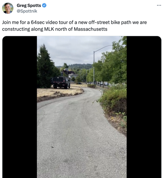
The Rainier Valley Neighborhood Greenway opened in 2017 with a key piece missing: A connection the final block or so to the I-90 Trail in Sam Smith Park.
“One of the coolest ideas in the plan is the new connection to the I-90 Trail,” I wrote in a September 2015 post about the greenway plan. “This was one of the more difficult puzzles in the whole route. All the other connections from the trail to the planned greenway route have ridiculously steep hills.” But when the route opened, it dead ended at the park with no clear way to get to the trail without hopping a curb and biking up a grassy hill. It has been that way ever since.
The problem was not Seattle, it was WSDOT. Sam Smith Park is a freeway lid that WSDOT built above I-90 as part of that freeway project. Even though SDOT was paying for and building the trail link, which would improve the connectivity of the state’s trail, WSDOT wanted to charge SDOT perpetual annual rent of $24,000 per year, increasing with inflation. But as Ryan Packer reported in November, the city and state had finally found a way forward.
Once the connection is in place, the Rainer Valley Neighborhood Greenway will be much more useful. The winding and hilly route travels along side streets near Rainier Avenue S as best as is possible. Though it was intended to act as something of an alternative to taking Rainier Ave, it is not comparable. The greenway is far hillier and longer than Rainier, which cuts a relatively flat diagonal across the valley’s street grid. There are many destinations along Rainier that the greenway does not serve. As a Rainier Ave alternative, it fails.
However, if you think about it as its own thing, a meandering and comfortable route through the neighborhood’s side streets, it’s mostly great (aside from one extremely steep block of 38th Ave S in Columbia City that should not be part of a supposedly all ages and abilities route). Neighborhood greenways are best when they are creating their own paths rather than when they are used as an alternative to installing bike lanes on a street that needs them. They have the ability to connect homes, parks, schools and more in a different way than we are used to. In infrastructure terms, a neighborhood greenway is really just a coordinated series of street crossing improvements, traffic calming and signage. But in a city with streets as confusing and hilly as Seattle, it’s especially useful to have a bread crumb trail to follow because if you make one wrong turn you might end up having to scale a very steep block.
If you’ve never ridden this route I highly recommend it, especially once the I-90 Trail connection is in place. You can take it all the way from I-90 to Rainier Beach, passing many neighborhood parks along the way. One popular alternative to the steep Columbia City section is to take Letitia Ave S and 35th Ave S between S Charlestown St and S Ferdinand St. Letitia is a lovely little street.


Comments
2 responses to “After 6 years of red tape, SDOT is linking the Rainier Valley Greenway to the I-90 Trail”
I look forward to riding this new connection on my morning commute.
It has never made sense to me that there was a sidewalk connection to the I-90 trail just two blocks east at the end of 29th Ave S, but essentially paving a new sidewalk at 28th Ave S for the greenway was somehow a major impasse. And that somehow with all of the playgrounds, tennis courts, bike polo, picnic table, soccer fields, and a bike & walking trail already on the lid, THIS new sidewalk was the one thing that was going to require SDOT to make a five-figure lease payment to WSDOT every year.
I completely agree with everything in this article. The Rainier Valley North / South Greenway is a wonderful route, though absolutely not a direct and flat route through the valley like Rainier Ave S would be. It’s much prettier and calmer, though!
“However, if you think about it as its own thing, a meandering and comfortable route through the neighborhood’s side streets, it’s mostly great (aside from one extremely steep block of 38th Ave S in Columbia City that should not be part of a supposedly all ages and abilities route).”
There’s also a very steep section on 37th Ave S between Hudson & Dawson (on the other side of Rainier Ave S) that would have most newer or less strong southbound riders dismount to summit.
I’ve enjoyed riding the Greenway many times, but there’s little of it that I would truly call “all ages and abilities”, since on top of several steep sections the route is shared with cars with no separated bike lane or physical protection and there are a couple of busy crossings without lights/beacons. Kenyon is a particular standout, as this is a busy road and immediately adjacent to Aki Kurose middle school. I would reserve the “all ages and abilities” label for a relatively flat separated trail where the worst that could happen is that a child, senior, or new rider might get clipped by another cyclist or hit a tree root.
I’ve actually found the RRFB at crossings like Othello to be really dangerous, if you press the cyclist button on the curb and expect drivers to see and stop for you as a road user. It’s my experience that drivers are used to ignoring RRFBs if they don’t see _pedestrians in the crosswalk_; I think they scan the crosswalk, think the person has already crossed, and look straight through a cyclist starting across _in the street_. I’ve nearly been hit twice at Othello when an east or westbound vehicle has slowed for me, and one approaching from the other direction failed to stop.