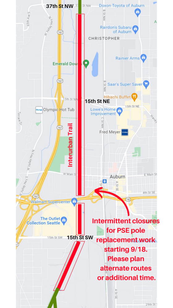
Starting today, Puget Sound Energy crews will be working along the Interurban Trail between 37th Street NW in Auburn and the Boeing Auburn facility near 5th Ave N in Algona. The trail should generally be open, but crews will close it as needed while installing utility poles. Flaggers will instruct trail users on what to do.
Unfortunately, there’s no schedule for when these closure will occur, and there is no established detour route. PSE also does not yet know when construction will end.
My biggest concern would be any closures near SR-18 where the alternatives to the trail are extremely concerning. C Street, the nearest detour option, is a scary mess of freeway ramps that is not bike-friendly. There is a skinny and almost hidden walking path squeezed between the highways ramps and the railway that connects a bus stop on C Street south of SR-18 with the Sounder Station parking lot north of the highway, but I’m not confident trail users would find this without the help of detour signage. Even if a rider does find this path, there are still significant challenges for navigating back to the trail that I’m not sure people will find on their own without help or previous knowledge of the area. I strongly suggest that PSE crews never fully close this part of the trail. Holding folks for a few minutes until flaggers can let them through safely would be much better than sending people on a very dangerous mission to find a way to cross SR-18. If a closure cannot be avoided, trail users will need assistance finding a reasonable detour.
As a side note, perhaps it should not be this dangerous and confusing to walk or bike across SR-18.
The first I heard of this work was from a recent phone call from a reader who noticed some markings on the trail but was having trouble figuring out what was going to happen. I didn’t receive an official notice of the work until Friday afternoon for work scheduled to begin Monday morning (today). This does not give people enough time to plan, and it also does not give folks the time needed to work with PSE to find a workable detour plan.

Due to public safety, sections of trail where crews are working will be closed when setting poles or moving trucks/equipment. Flaggers will be on the trail to direct people around the work area. No detours are available, but the trail will remain open when not actively installing poles.
Please follow all posted signs and directions from crews. Plan for extra time and/or alternate routes. We will share construction end dates as soon as they become available.


