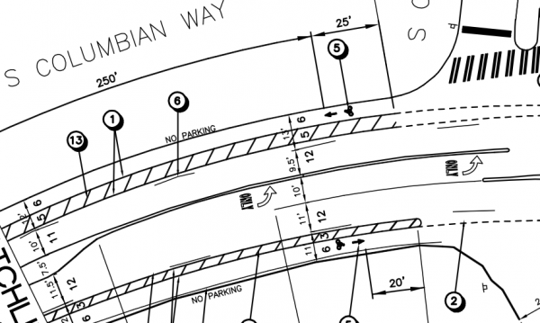
SDOT repaved and redesigned S Columbian Way between 15th Ave S and Beacon Ave S last year, and the interim results are promising:
• Traffic volume up 15-20%
• No change in number of collisions
• 85th percentile speed down from 38.5 to 36.1
• Top-end speeders (40 mph +) down 47%
Now, SDOT is proposing to extend the redesign east, continuing on S Alaska St. to MLK where it will connect to the light rail station and existing bike lanes on Alaska St. that lead into the heart of Columbia City. This rechannelization will not come with a complete repaving like last year’s project, and the current sub-par state of the street’s sidewalks will remain until a future, larger project can fix them.

When we wrote about this project last year after an early meeting, we suggested the city take advantage of the relatively low traffic volumes and pursue more ambitious bike amenities, such as buffered bike lanes. SDOT now plans to do just that for portions of the project.
When a center turn lane is present to allow for people to turn into driveways, the road will have 5-foot bike lanes. But for segments where there are no places to turn, larger bike lanes with painted buffers will be installed, giving a little more space and safety (and perhaps a chance to take in the beauty of this road, which is one of my favorite spots in the city).
The project will connect neighborhoods downhill, including the Rainier Vista housing project, to both mid-Beacon Hill and Columbia City centers, Mercer Middle School, the library, grocery stores and other bicycle routes (including, of course, the proposed Beacon BIKES neighborhood greenway). It also aims to reduce the rampant speeding currently on the street. Speeding on this beautiful section of road is even worse than the section changed last year. From SDOT:
• 85th percentile speed: 39.3 westbound, 41.5 eastbound (downhill)
• 87% of drivers are traveling over the speed limit (30)
• 17% are traveling over 40 mph
That bears repeating: Only 13 percent of drivers on this stretch of roadway obey the speed limit. When so few obey the speed limit, the problem is not entirely the people driving. The problem is the road’s design. If you design a road like a four-lane highway, people will feel comfortable driving like they are on a highway. When you design a road for safer, neighborhood-appropriate speeds, people are more likely to drive at those safer speeds. This has been shown many times and forms the basis for all our unpopularly-named “road diets.”
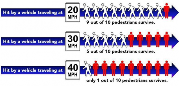
SDOT attached the following image to a presentation on the project. It’s a statistic we use a lot, but here is a way visualize the danger of speeding:
 The project also fixes a strange design issue that currently makes driving a little more annoying and dangerous. Today, vehicles traveling downhill to MLK in the left-hand lane suddenly find themselves “trapped” in the left turn lane, forcing them to merge right in order to continue straight through the intersection. The project will fix this problem so the general traffic lane continues straight or turns right, and traffic turning left onto MLK will merge into a left turn lane, as is more standard.
So this project has many positives: Safety enhancements, an incredible new connection between these two great neighborhoods, a chance for the low-income families at Rainier Vista to ride safely to the grocery store, employment centers and schools and improvements to the road experience for all users.
It also shows that SDOT is looking for oportunities to take out unused left turn lanes in exchange for increased bike lane and buffer space. This is an encouraging development, with the Dexter project as the first big example of this strategy. The department also has plans to remove the center turn lane on 20th Ave NW in Ballard to make space for bike lanes in each direction. The 7th Ave buffered lanes downtown and buffered lanes on NE 130th St were also made possible by removing an underutilized turn lane.
To be sure, turn lanes that are needed can be a relatively safe and efficient way to move traffic. Unused or underused left turn lanes, however, take up valuable road space that in many cases could be better utilized by creating a more inviting bicycle facility. They also encourage unsafe (and illegal) passing of slower-moving vehicles and are often used as dangerous mid-street loading zones for delivery trucks (also illegal).
As the city begins to design the next generation of bicycle facilities, which should be geared toward a far wider group of people of all ages and states of physical ability, taking a close look at the necessity of turn lanes could be one more tool for creating safer bicycle facilities and safer streets for all users.
SDOT Director Peter Hahn will decide whether to approve the S Columbian Way project in July. If he does, it could be completed by August of this year.


Comments
5 responses to “S Columbian Way project to calm traffic, connect Beacon Hill and Columbia City”
Yes Please. This is my neighborhood and is deeply in need of safe cycling and pedestrian areas.
This is long overdue and very exciting! My dream is to have wooded bike trails in the northern section of Cheasty Greenspace, the area that this bike lane passes through. We are currently restoring the forest on the south side of the street and building Seattle Parks standard walking trails. We hope to continue this new park on the north end and include mountain bike trails. Contact me if you want to get involved or come help us during our work parties.
Stay up to speed by liking the Facebook page – http://www.facebook.com/pages/Friends-of-Cheasty-GreenspaceMt-View/167263430000172
I can’t find a link to SDOT’s plans about this project. Can anyone help?
This is one of the best places in the city to blow past the speed limit. On two wheels.
great news! I have been that motorist, frustrated and confused by that silly turn lane.