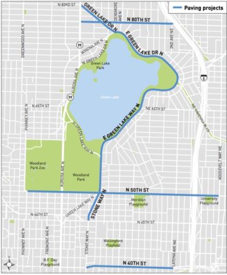
 A series of planned paving projects in Green Lake and Wallingford are a big chance to make significant improvements to the North Seattle bike network. And of course, the city could save a lot of money by making these improvements at the same time the streets are being torn-up for paving, anyway.
The collection of paving projects represents a new approach the city is taking for handing paving work. Instead of making each streets its own project (with its own public outreach and contract bids), SDOT is grouping nearby projects together and beginning outreach on the group of projects earlier.
SDOT is hosting an open house 5:30 p.m. – 7 p.m. Wednesday at Green Lake Elementary. They will also host a drop-in session 10 a.m. – 11:30 a.m. June 10 at Billings Middle School. An online open house will go live Wednesday (UPDATE: Here’s the survey link. It’s open through June 12).
While these streets won’t actually be paved until 2019 or so, you have a chance to be heard early to make sure safe streets and key bike network connections are included from the start. This should be a much better process than the old way, where people would learn late in the design process that a paving project had neglected bike lanes. This happened on Roosevelt Way, for example, and it took a huge popular push and a lot of re-design work to add the bike lane to the project before work began.
Planned projects in this group include:
- N 40th St: Stone Way N to Latona Ave NE
- N 50th St: Phinney Ave N to Roosevelt Way NE
- Stone Way N: N 45th St to N 50th St
- E Green Lake Way N/E Green Lake Dr N: N 50th to Densmore Ave N
- Green Lake Dr N: Densmore Ave N to Aurora Ave N
- N 80th St: Aurora Ave N to I-5 overpass
This may also be a chance to finally make serious improvements to the terrible intersection of 50th/Stone/Green Lake Way. Today, it doesn’t work for anyone. A radical solution might be needed…
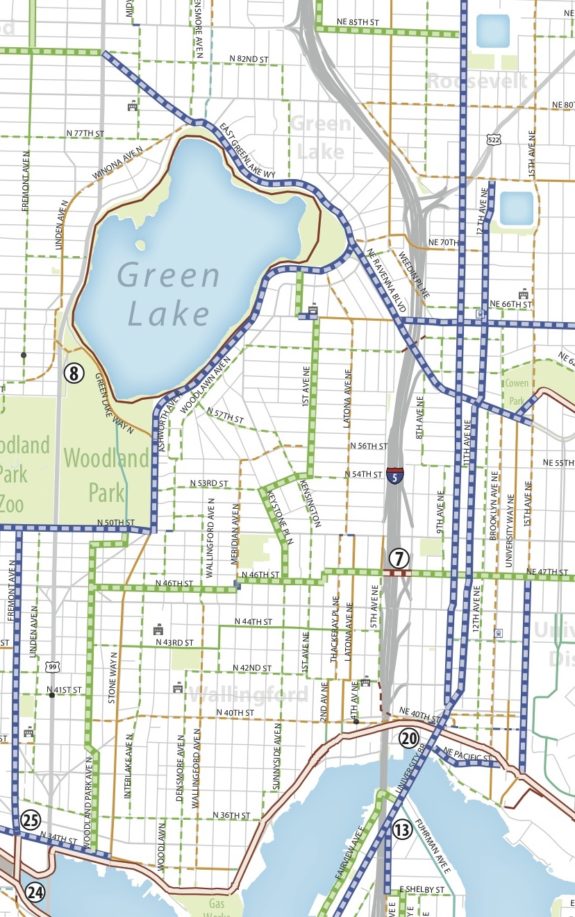
For reference, here’s the relevant section of the Bike Master Plan. As you can see, most the planned paving projects are slated for bike network improvements:


Comments
15 responses to “Green Lake and Wallingford paving projects are a chance to make major bike network improvements”
At minimum, I hope people who live near repaving projects use the SDOT investment in their arterials as an opportunity to ask that their streets to be signed to a safer, more neighborhood-friendly 25 MPH.
The Wallingford, Green Lake and Licton Springs neighborhoods where these repaving projects are going in could definitely use some intersection improvements to make crossing busy arterials more human-centered — even stop bars at existing crosswalks would go a long way toward calming traffic. I wrote a little more about this particular repaving project at the Wallyhood blog http://www.wallyhood.org/2017/05/repaving-lead-walkable-wallingford/#comment-276340&gsc.tab=0
Signing doesn’t really matter if the design speed isn’t that low.
I rode Woodlawn and Kirkwood this morning, thinking they might be safer than they currently are. I didn’t look closely for speed limit signs, but they have arterial center lines despite being rather curvy, residential and not being primary through streets. If there are 30MPH signs, they should be removed. Also with all the curves I’m guessing there are at least a few yellow 25MPH signs.
To me that implies the “actual” speed limit is higher. I’d personally like to see yellow 25MPH signs at turns replaced by white ones or yellow 20MPH signs. The drivers that passed me seemed to be aiming for the speed limit more than the design.
65th street between I-5 and Greenlake is similarly an ‘arterial’ that already has a somewhat narrower profile and could be dropped to 25 without causing delays for anyone.
The intersection at 50th/Stone/Green Lake is much better than it was before, and even Stone Way and Green Lake north of 50th are passable if not great.
The two places that really need improvement aren’t even on the map:
1. Green Lake south of 50th is basically an on/off ramp for SR-99. Five lanes is completely ridiculous given the traffic volumes, and the fact that it severs what’s otherwise a walkable neighborhood. Cut it down to 3 lanes, put in bike lanes, and at least two marked/signaled crosswalks.
2. 50th east of Stone Way is another car sewer. If we’re able to justify bike lanes on 65th with its frequent transit service, 50th should be a breeze since it has absolutely no transit service to speak of. Put in some more marked/signaled crosswalks.
The only moderately difficult-but-needed thing I can see on the map are the bike lanes on 40th. I anticipate those will go away after the half-dozen people who use on-street parking on 40th complain to SDOT, because I just don’t see how you can put bike lanes in and keep the parking.
Whatever they come up with for 50th/Stone/Greenlake, I hope you’ll be able to bike around the intersection (Dutch-style), instead of through it. They should be aiming for full separation, with no green paint in the middle of the street.
As someone that’s walked around that intersection plenty of times… it takes a hell of a long time because of very long signal phases and lots of “green arrows” that limit the number of crosswalks active in any phase. You want to have to wait twice to go through southbound from Green Lake Way to Stone? You want to have to wait three times to turn left from eastbound 50th to Green Lake Way? I sure don’t!
Of course, what I really want is Green Lake Way south of 50th closed and abandoned, the street grid restored to its original function, and the intersection at Stone/50th made smaller and simpler. The problem with this is that it encourages more I-5 traffic on 45th, which is more important than 50th for transit and local access.
But if you want to ride around the outside you can do it now in the crosswalks, and see just how much protection you really get from it. From my experience walking and biking through that intersection… I don’t think it’s much. You’re still exposed to people turning right.
Just looked at the 2017-2021 BMP update – no bridge at 47th there, but they do include a project (of type TBD) to be implemented on 45th between 4th Ave NE and Brooklyn Ave NE. Not sure why it doesn’t connect west to a N-S route on Latona.
@Dave: Heh, I think you meant to respond to my other post. But that’s fair, because the two things are connected.
I’ve thought removing Green Lake Way south of 50th and restoring the original street grid was a good idea for years. I’ve thought closing the I-5/45th interchange to SOVs was a good idea for nearly as long. But I do recognize that doing both together would be tough.
North Seattle (here meaning anything north of the CBD, including at least Mercer and maybe Denny) is massively over-provisioned with north-south vehicle capacity compared to east-west, so that anyone in a car around I-5 that needs to be on 99, or vice-versa, finds few good places to make that transfer. This, I believe, is one of the real big-picture themes of Seattle transportation, reverberating from the Mercer Mess to 145th. Green Lake Way south of 50th is a key part of the path from the big Aurora/46th interchange to I-5, so it’s in some sense on the “good” side of our road capacity balance, and it helps keep through-traffic out of the way of the 44 and Wallingford’s main commercial area. Of course, the ultimate solution is reducing north-south vehicle traffic and improving transit function at every opportunity… but if Green Lake Way went away I think we’d have to look hard at where trips between I-5 and 99 would flow to, and be sure those impacts weren’t worse.
Ho hum. I imagine the bigwigs at SDOT and in the Mayor’s office will, as usual, listen politely, make a few soothing noises, and then proceed to ignore us and go back to designing streets that further reinforce the car-dominated status quo. But hopefully the day will come that the politically clueless Seattle bike lobby actually figures out how to make a persuasive argument to the people who really design streets around here.
What’s the plan for the I5 crossing at 47th? Is that realistic? The east-west connector here is limiting. I find that 51st st works well going east from the 50th st bike lane that ends at Stone Way. Has this ever been considered for a greenway?
There are many bridges that do similar things around here: over 99 at Henderson, over I-5 at 195th, over 405 at NE 100th… This one would have to be longer than most because it needs to clear 5th and 7th also (they’re essentially part of the interchange). But I don’t think this bridge has to be as fancy as the Northgate one. All those bridges have pretty crummy landings; I think we could do better here without disrupting much.
But I don’t think there’s any actual plan to fund or build it. We shouldn’t let some abstract promise of this bridge, which may not be built for a generation or more, distract us from requesting changes in a shorter time frame on 45th. With light-rail opening near 45th in the U District soon, there will never be a better opportunity to design 45th for less motor-vehicle traffic without that amounting to a general reduction in access.
I’ve asked SDOT to include in this project repaving the two WB blocks on Winona between E Green Lake Way and N 77th. 77th is less-arduous climb up toward Greenwood than 83rd (a signed bike route) and is a bike route with much better traffic calming.
Avalon and Roxbury, too, Meetings last week and yesterday. But those are in West Seattle, so who cares?
https://www.seattlebikeblog.com/2017/05/23/citys-2019-plans-for-sw-avalon-would-dramatically-improve-bike-access-to-the-heart-of-w-seattle/
So will they say they have no funding for the planned protected bike lane along Green Lake? Just repave and leave it for later. That’s terrible.