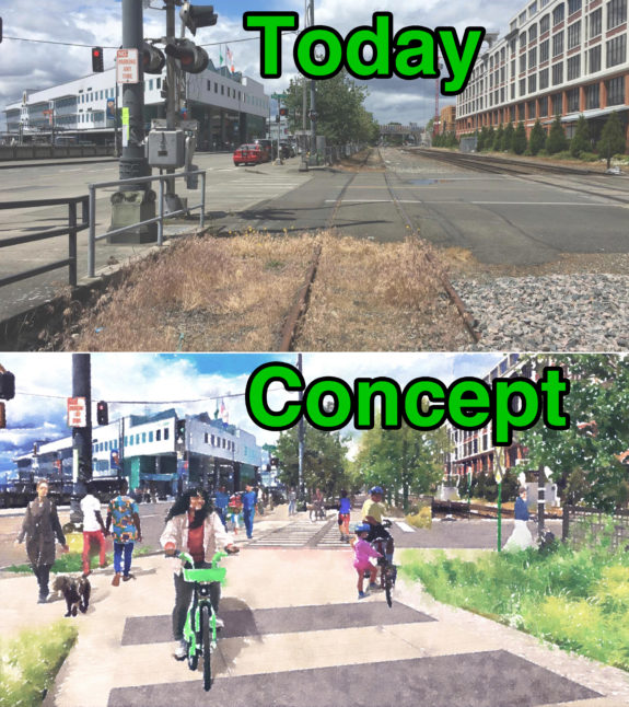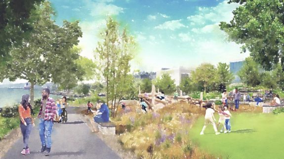
A group of philanthropists will fully fund a $45 million set of upgrades to the downtown waterfront north of Pier 62, where the existing under-construction Waterfront Park project ends. The Elliott Bay Connections project includes cove and park improvements in Centennial and Myrtle Edwards Parks as well as a new walking and biking trail along the defunct Benson Streetcar rails.
The new trail will exist alongside the city’s planned protected bike lanes on the waterfront side of Alaskan Way, which is part of a larger street safety project for the relatively low-traffic street. The usability of the planned trail will rely heavily on whether Alaskan Way feels safe to cross.
The group hopes to begin construction in early 2025 so that it can be complete before Seattle hosts the 2026 World Cup in June. Expect a lot of community engagement this fall and winter.
The press release (PDF) claims the project “will be undertaken at zero cost to taxpayers”:
Elliott Bay Connections would construct a new pedestrian and bicycle greenway connecting the new Waterfront Park to the Olympic Sculpture Park (from Pier 62 to Pier 70) and would restore and revitalize Myrtle Edwards and Centennial Parks, including the restoration of public fishing at Pier 86. Private funding will underwrite the estimated $45 million cost of construction. Philanthropists Melinda French Gates and MacKenzie Scott, The Diller-Von Furstenberg Family Foundation, and the Expedia Group are the donors to the EBC project.
The private funding helps close a frustrating gap in waterfront planning. After so many years (decades, really) of planning and construction, ending the Waterfront Park project at Pier 62 rather than connecting it to Myrtle Edwards Park has stood out as a major missed opportunity to finally have a cohesive and connected waterfront. It took an enormous amount of bicycle advocacy work over many years just to get the city to commit to connecting the existing Elliott Bay Trail to the new waterfront bike path. Now, unexpectedly, we are set to end up with two connections.
“Cascade Bicycle Club is excited about this historic investment in making Alaskan Way more bikeable, walkable, and safer for all users,” said Cascade Executive Director Lee Lambert in the press release. “Along with the planned bike lanes on the western waterfront side, the green space and additional bike path and better sidewalks on the eastern side of Alaskan Way will support multiple user groups—leaving the western side for transportation and the eastern side for recreation.”
The proposed walking and biking trail will cross the street near the bend where Broad Street and Alaskan Way meet at the entrance to Myrtle Edwards Park near the sculpture park. From there, it will replace the abandoned streetcar rail line, which is adjacent to active freight rail lines. This will require a new barrier of some sort, effectively extending the reach of public space further northeast from the waterfront. It will help connect Belltown to the waterfront, reducing the railroad crossing distance at each intersection.
The park improvements include a much-needed kids play area, something I have found oddly lacking there as a parent. It will be a huge hit, especially great for biking parents. I smell a new Kidical Mass hotspot in the making.


Comments
3 responses to “New and upgraded Elliott Bay Trail will be privately funded”
Billionaire philanthropists donate to a bike path across the street from one the city is already planning to do, aim to complete the project just in time for a big sporting event on the opposite end of downtown, where there are enormous gaps in the bike network that nobody plans to do anything about.
Is this a cross-post with The Needling? It’s a bit on the nose :-P
This has… concentric layers of farce, of course. Soccer is so beloved around the world that people will just stand there with their money in their outstretched hands waiting for it to be taken by whatever stupid and corrupt money grab FIFA comes up with. The expansion to a 48-team World Cup makes the tournament worse and is unjustified by any competitive logic, only the logic of, “More teams, more games, more money.” Holding the tournament across three countries the size of the USA, Canada, and Mexico makes the tournament worse, adding travel hassles for anyone trying to follow it across multiple games — problems made yet worse by the real possibility of US border policy taking an authoritarian and discriminatory turn by 2026. Given that it is a USA-Canada-Mexico tournament, holding the final in a football stadium without a permanent grass surface that’s kinda close to the richest city in North America instead of an iconic soccer stadium in the biggest city in North America is a damn crime. With so many cities to choose from, holding games in places like Seattle where temporary grass surfaces need to be installed is bad for everything: worse quality than permanent grass fields, doesn’t solve the problem for teams that play there regularly, doesn’t reward venues that push soccer forward in the US by maintaining permanent grass surfaces. Of course there are strong urbanist, environmental, and financial advantages for stadiums that can host multiple sports, but… this is a big soccer tournament, not the Urbanist Olympics.
So now we’ve zoomed into Seattle. I get that this project is about general tourist stuff more than stadium access, but… a few blocks away from the stadium is the unceremonious end of the 2nd Ave Cycletrack, where southbound riders are dumped out into a left-turn lane, and if they follow the curb lane like a normal person (following sharrows no less!) they then get dumped into the inner lane of eastbound Jackson, along with the streetcar tracks! IDK, if I was a Seattle-associated billionaire and wanted to help make the city look less stupid to any unfortunate international guest that tried to ride a bike here… I’d think about that intersection before the north waterfront. I guess you don’t get to be a billionaire by being a world-class bike lane understander.
The former George Benson waterfront streetcar ROW is owned by the public, so that has an opportunity cost.