— Advertisement —
  • WSDOT won’t work with SDOT to connect the Rainier Valley Greenway to the I-90 Trail

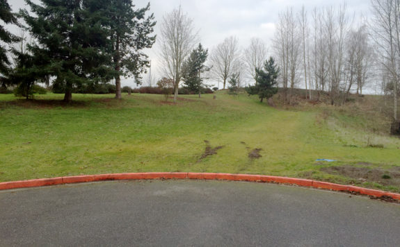
    Photo of the end of the road. A grassy hill with a well-trodden path lies beyond the street.
    Where the greenway ends. 28th Ave S just north of S Massachusetts Street.

    For years, WSDOT has resisted working with Seattle to connect the Rainier Valley Neighborhood Greenway to the Mountains to Sound Trail (AKA the I-90 Trail), according to reporting by Ryan Packer for the Urbanist. Packer requested emails between the two public agencies to uncover why this final connection remains incomplete years after the rest of the route opened, and his findings are extremely frustrating.

    The needed connection is very short, spanning a half a block at most from where 28th Ave S abruptly ends and the regional trail just a couple hundred feet beyond. The land the path needs to travel through is already flattened down by people walking and biking across the grass, a clear sign that a pathway is needed here. Also known as “cow paths,” informal walking paths like these show transportation agencies where unmet facilities exist in the communities they serve.
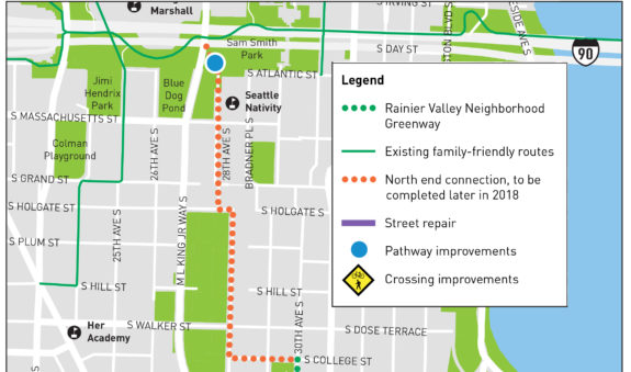
    Project map from 2017.
    This 2017 construction notice said the “pathway improvement” was coming in 2018.
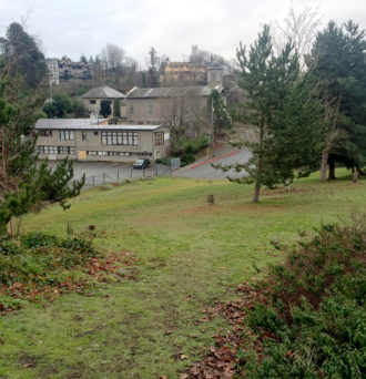
    Photo looking south at the grassy area where the path should go.
    Looking south toward the greenway’s end (photo taken in 2016, but the area sadly hasn’t changed much).

    This grass is part of WSDOT’s lid over I-90, which created Sam Smith Park and is home to the I-90 Trail. The I-90 Trail is a major transportation facility of regional importance that includes investments from many agencies along its route including WSDOT. The trail connects some of the state’s largest employment and residential areas. Yet Packer’s reporting shows that WSDOT has put up major road blocks for at lease half a decade to prevent SDOT from building a short trail connecting the local biking and walking network in southeast Seattle to this regional backbone.

    “A set of emails obtained by The Urbanist reveal the long battle between SDOT and WSDOT to come to an agreement around use of the property,” Packer reports. “That battle has continued into 2021, when a lease agreement was on the verge of being signed between the state and the city early this year, but city staff were surprised to find that the proposed agreement would have committed SDOT to paying nearly $24,000 per year to WSDOT in perpetuity (tied to inflation) after paying to design construct the trail connection itself.” (more…)

    — Advertisement —
  • Sunday: Celebrate the new Union Street bike lanes

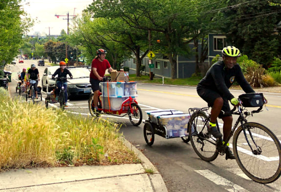
    People with bike trailers hauling lots of food up the hill in a bike lane.
    The Union Street bike lanes being used to haul freight up the hill. Riders, led by Joseph Roberts, on a Pedaling Relief Project food rescue mission, delivering donations from PCC to the Byrd Barr Place food bank. We hauled 675 pounds of food that day.

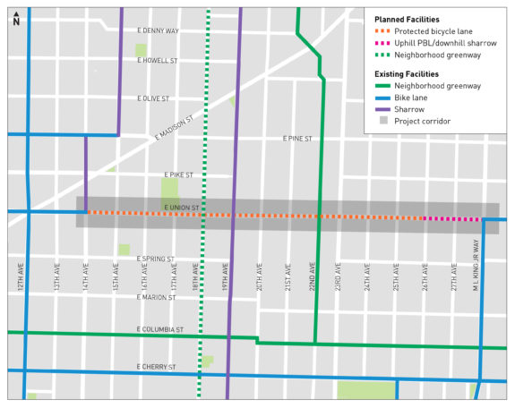
    East Union Street now has protected bike lanes from 14th to 26th Avenues, providing a lower-stress way to climb the unavoidable ridge that peaks around 18th and 17th Avenues through the Central District.

    Before the new lanes were installed, skinny paint-only bike lanes appeared and disappeared seemingly at random along the route. Now they are consistent, traveling between the sidewalk and parked cars. The bike lanes also calm traffic, which can get going pretty fast down the steep hill. People driving used to swerve into painted bike lanes to pass turning cars (and cars stopped to let people cross the street). The new design makes crossing the street significantly more comfortable.

    The bike lanes are well-used heading up the hill. Downhill use is a bit more mixed, which makes sense. People who already bike in the area are used to bombing down Union’s steep hill. The new bike lane requires users to brake and go a little slower. I don’t see this as a problem, though. People have choices now. If you like bombing the hill, take the lane like before. But if you’d rather take your time, then use the bike lane. It’s great to have different options for different people.

    Project map.
    From SDOT.

    Thanks to people who pushed back on the original design, the bike lanes continue through the intersection with 23rd Avenue. This provides a comfortable bike connection for people traveling from east of 23rd, but it also provides a connection to the many destinations at the intersection itself.

    To celebrate the new bike lanes, Central Seattle Greenways is inviting everyone for a Sunday ride. Meet 10:30 a.m. at the little park at 15th and Spring. Details from Central Seattle Greenways: (more…)

    — Advertisement —
  • N 34th Street bike lanes fix some of the challenges near the Fremont Bridge

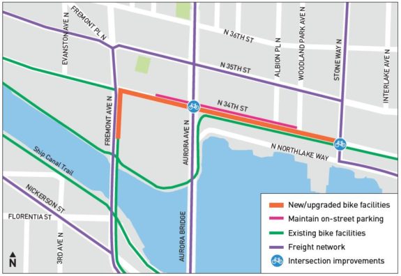
    Project map.Person biking in the new bike lane facing west just past Stone Way.The latest upgrade to the bike connections around the Fremont Bridge make some very significant improvements, though larger solutions are still needed to make it truly comfortable for people of all ages and abilities.

    The Burke-Gilman Trail is the region’s busiest bike trail, and it travels under the Fremont Bridge, which is the region’s busiest bridge for biking. So connecting the two is a very obvious, high-demand need of regional importance.

    The biggest changes are new protected bike lanes for most of N 34th Street between Fremont Ave and Stone Way, an extended bike lane for people biking north across the bridge, and a much larger sidewalk extension for trail users at Stone Way. These are all significant improvements.

    N 34th Street already had painted bike lanes, but they were fairly skinny. Worst of all, the westbound lane was located in the door zone of parked cars and was often blocked by people making deliveries or dropping off passengers. The redesigned bike lanes make these few blocks much more comfortable.

    New larger sidewalk extention where the Burke crosses Stone.Large numbers of people transfer from the Burke-Gilman Trail to N 34th Street and Stone Way, making that intersection one of the most important and complicated intersections in the city’s bike network. Trail users often stack up on both sides of the intersection waiting f0r the walk signal. So SDOT significantly extended the sidewalk and curb near Solsticio Café, providing more protected space for people to wait and to navigate around each other. (more…)

    — Advertisement —
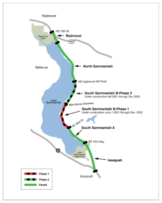
  • Final stretch of E Lake Sammamish Trail under construction, signalling the end of 4 decades of fighting

    Map of the trail segments. “If the trail is built, say the neighbors, it would violate their property rights and privacy, and would be challenged in court,” wrote the Seattle Daily Times in 1982 in a story about King County’s plan to convert the defunct rail line along the east side of Lake Sammamish into a walking and biking trail.

    The rail line in question is part of the same historic line that had become the Burke-Gilman Trail just a few years prior, which was a huge and immediate success. King County was looking to repeat that success further down the line.

    But that threat of legal challenge was very much real, and the owners of the extremely valuable lakefront property had more than enough money to fund as many legal battles as possible to delay or stop the trail. And they did, even taking the case to the doors of the U.S. Supreme Court in 2019. The highest court in the nation declined to hear their appeal, finally ending nearly four decades of legal threats and actions.

    Paving the East Lake Sammamish Trail was first put to King County voters as part of a 1982 parks bond measure. Of course, it may not have taken this long had voters actually approved that bond measure, which failed alongside every tax measure on the ballot. It’s hard to imagine a parks measure failing these days, but the early 80s were not a good time for tax measures. (more…)

    — Advertisement —
  • City puts final touches on important José Rizal Bridge bike lanes

    Seattle is working to catch up on bike projects after Mayor Jenny Durkan paused or cancelled nearly all bike plans during the first half or so of her term. And though it may be nearly impossible to completely make up for lost time, SDOT has been working on many significant bike improvements. So stay tuned for more coverage of new bike infrastructure around town, a lot of which is really exciting.

    People biking in the new bike lanes with downtown in the background.A bus stops at a bus stop next to the bike lane. First up, the José Rizal Bridge just got a major upgrade with new protected bike lanes. The lines have been painted for months, but the city installed the plastic pylons this week.

    The relatively short project connects from King Street in the International District to S Charles Street on Beacon Hill. From Charles, people can either continue south up Golf Drive S to 14th and 15th Avenues S, head west to 12th Ave S, or head east to take the connection to the Mountains to Sound Trail.

    The bridge is one of the most important bike pinch points for many southend bike routes. So while the length is short, the importance of the connection is huge. Not only will the bike lanes make biking more comfortable, but it should also dramatically reduce the number of people biking on the sidewalks to avoid the often fast traffic.

    Oh, and traffic should be calmer and safer, too. SDOT data shows that during the 13 years from 2004 to 2017, there were 15 collisions with people walking or biking at the intersection with S Weller Street, 24 collisions between Weller and Charles, and 5 at the Charles intersection. 44 people in just 13 years. That’s why SDOT saw this project as not just a bike lane project, but a Vision Zero project. The bike lanes help narrow the driving space to reduce dangerous passing and speeding. It also means that anyone crossing the street, including people trying to access these busy bus stops, will have a shorter distance to cross. If it works as well as it should, then every three or four months from now on a person will be spared a potentially life-threatening collision near this bridge. (more…)

    — Advertisement —
  • Alert: Interurban North Trail will close for 10 months near Lynnwood Transit Center

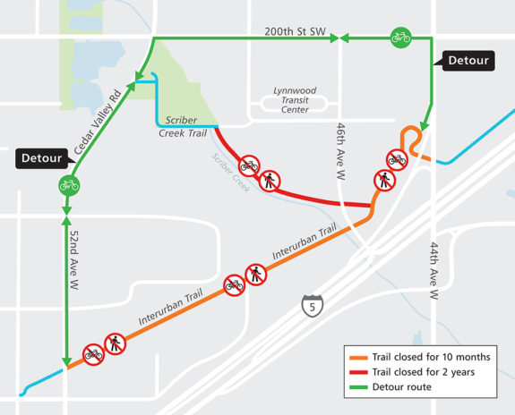
    Map of the closure and detour.Construction to prepare Lynnwood Transit Center for light rail and build a parking garage will close the Interurban North Trail between 52nd Ave W and 44th Ave W for two years starting May 12, according to Sound Transit.

    This is a significant change from the initial closure schedule announced in the fall, which anticipated only two months of closures in 2021 and six months in 2022.

    The detour route is unchanged from the initial announcement. It includes a busy stretch of 200th St SW and the sidewalk of 44th Ave W (there is no curb cut from 44th to the trail, so the sidewalk is the only option unless Sound Transit adds a ramp). I suspect most users will use the sidewalk on both 200th St and 44th Ave in both directions, even though it’s really not wide enough for heavy mixed use. Cedar Valley Rd and 52nd Ave W both have painted bike lanes.

    The Interurban North Trail is the primary bike route from Everett to Seattle and points in between, following the right-of-way from a former electric streetcar line (this is the “Interurban” those statues in Fremont are waiting for). The last train ran in 1939, and many parts of the right-of-way have since been chopped up, especially by the construction of I-5. Surviving sections serve as vital sections of an important regional bike route, but there is a lot of work to do to make it a complete route comfortable for people of all ages and abilities to use.

    Details from Sound Transit: (more…)

    — Advertisement —
— Advertisement —

Join the Seattle Bike Blog Supporters

As a supporter, you help power independent bike news in the Seattle area. Please consider supporting the site financially starting at $5 per month:

Latest stories

— Advertisements —

Latest on Mastodon

Loading Mastodon feed…