— Advertisement —
  • After years of delay, improvements coming to 15th Ave S & S Columbian Way intersection

    Later this year, the Seattle Department of Transportation is set to complete improvements that will make it easier to bike through one of Beacon Hill’s trickiest intersections. The changes planned at 15th Ave S and S Columbian Way come three years after the department was originally scheduled to implement a much bolder reconfiguration of the intersection here, but that iteration of the project was cancelled after local opposition.

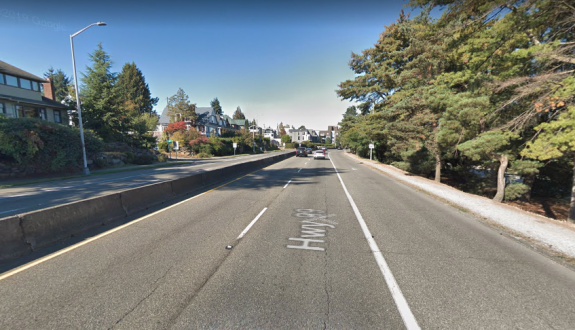
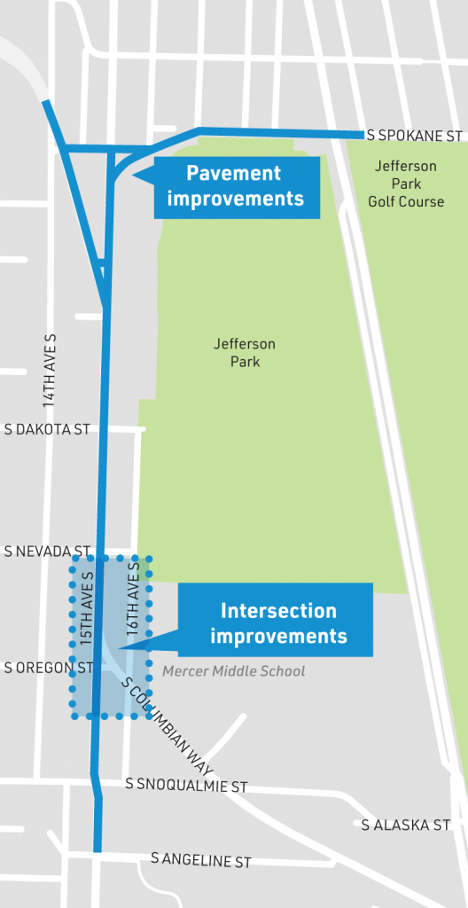
    SDOT is repaving a stretch of 15th Ave S, from Spokane to Angeline Streets. Most of the street here is two lanes in both directions without much street parking, and isn’t getting any additional space for bikes. This is unfortunate, as there’s plenty of room and no parking to fight over. Traffic volumes from SDOT’s last citywide volume report show similar vehicle volumes on 15th Ave S as on the segment of Rainier Ave S which has been converted to one lane in each direction with a center turn lane. It also has very similar volumes to S Spokane Street, also getting repaved here, which already has one lane in each direction with painted bike lanes.

    Map of 15th Ave S from Spokane to Angeline Street as highlighted
    Map of planned repaving and intersection improvements on 15th Ave S.

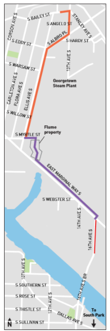
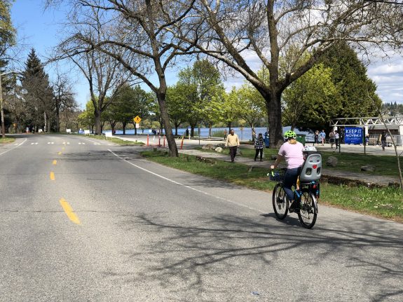
    SDOT is currently planning an all-ages bike route across Beacon Hill for 2023, and currently plans to route people biking onto Beacon Ave in this area. But on the north end of the hill, advocates are pushing for the protected bike lane to be routed onto 15th Ave. At the south end of Beacon Hill, SDOT already installed bike facilities on Swift Ave, which is what 15th Ave turns into. 15th Ave will continue to make sense as a bike corridor and an opportunity was missed here.

    One very wide curved street meeting another one going north south with vast space where they connect
    Arial view of the current configuration of 15th and Columbian Way.

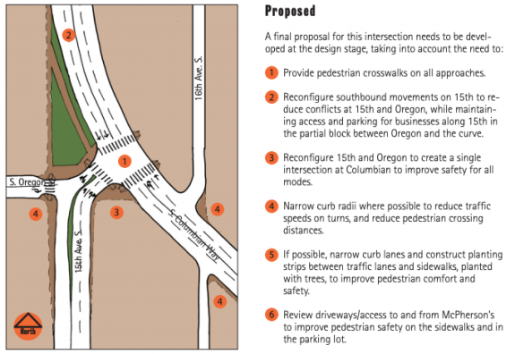
    As for the improvements at 15th Ave and Columbian Way, the plan that would have been implemented in 2018 directed all southbound traffic onto the curve of Columbian Way, with drivers wanting to continue on 15th having to make a right turn. This would have dramatically reduced the size of the massive intersection. A second crosswalk across the intersection from the middle school was to be added. A public plaza would have been created out of the excess street space, with space for people biking to get through the intersection via the crosswalks.

    Original design for the intersection described in the article.
    The original design funded and scheduled to be installed in 2018.

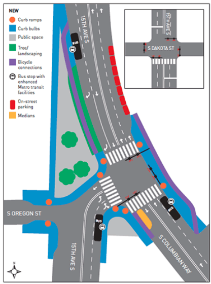
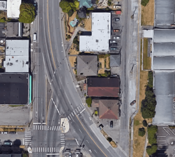
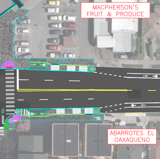
    The design now planned maintains one through lane on southbound 15th Ave S, doesn’t add any additional pedestrian crossings, and doesn’t include any space for people biking northbound from Columbian Way. But it does add a protected bike lane on southbound 15th Ave S by moving the parking in this stretch next to the travel lane. That protected bike lane starts very slightly out of frame at the top of the following image.

    Improvements planned this year as described in the article
    The planned 2021 improvements to 15th and Columbian. (Click to enlarge)

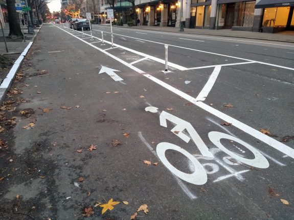
    On the south side of Oregon on 15th Ave, people biking will share space at bus stops with people entering and exiting buses, matching similar designs seen recently on NE 65th Street and 12th Ave S. Southbound, the bike lane disappears very shortly after the bus stop, making its utility questionable. Northbound, the bike lane extends nearly two blocks down to S Angeline Street, the street where the Chief Sealth trail terminates. But at Oregon street, people riding northbound are dumped onto the sidewalk.

    Two bus stops south of Oregon with loading space for buses and bike lanes existing in the same space
    Bike space mixes with bus loading zones south of Oregon Street at 15th and Columbian.

    Though the original redesign here was approved in 2016, improvements at this intersection date to at least 2008, when a reconfiguration very similar to the one proposed was suggested in an SDOT commissioned study, the Southeast Transportation Study.

    Sketch of street redesign similar to the 2018 planned improvements described above
    Proposed redesign for 15th and Columbian from 2008.

    With the project going in now, after years of delay, with most of the changes proposed along the way discarded, is a testament to just how much of an uphill battle it is to redistribute essentially any current street space allocated to vehicles.

    During the last full Seattle Public Schools school year (2018-2019), the southbound school zone speeding camera on 15th Ave S was the most active single camera in SDOT’s school camera arsenal. Over 800 tickets were issued on average per month during the course of the year, 8,012 in total, underlining just how much this intersection redesign is ultimately a school safety project. It’s also likely there would be zero changes happening here if not for the advocacy of groups like Beacon Hill Safe Streets, despite existing plans here on the books. The changes here are clearly hard-won, and should have an impact.

    This weekend and next weekend, SDOT will be closing Columbian Way immediately south of 15th Ave S. Traffic will be detoured via Snoqualmie Street and 15th Ave S. You can read more about the planned improvements here.

    — Advertisement —
  • Georgetown residents push to get a downtown bike connection back into plans

    A group of community leaders and residents of the Georgetown neighborhood have sent a letter this week to SDOT Director Sam Zimbabwe asking the department to “re-engage” on the issue of creating a dedicated bicycle connection between the neighborhood and the rest of the city via downtown Seattle. The letter cites systemic issues facing Georgetown that are not specifically related to the closure of the West Seattle bridge in March of last year, which has led to an increase of traffic diversion through the neighborhood and an increased focus on the transportation needs of the Duwamish valley. From the letter:

    Access to services outside our neighborhood remains a challenge. We do not have direct access to Rapid Ride, and our regular bus service is limited in destinations and times for essential services. Georgetown is not within a walk-shed of a light rail stop and we do not have shuttle service to the nearest station. Bike connectivity is dangerous for anyone who is not a seasoned rider outfitted with the experience and equipment to share routes with cars and freight in substandard conditions, which does not accommodate all abilities. While the bike link between Georgetown and South Park has been a very important and necessary project for which the community has advocated for years, we would like to re-engage on the crucial bike connectivity for Georgetown with the rest of the city, as funding for transit remains a challenge.

    A feasibility study on a Georgetown to Downtown all-ages bike route was one of the projects that SDOT “paused” in 2020 due to budget impacts caused by the COVID-19 crisis. Funding allocated to plan for an extension to the existing multiuse trail in SoDo was also paused at the same time. Last fall, the city council restored funding for planning for the Georgetown to Downtown connection as part of the 2021 budget.

    The planned trail between Georgetown and South Park is moving forward more quickly, with the city council also allocating construction funding for this project in the 2021 budget. SDOT is continuing design work on the trail so we should have more details on this in the coming months. Completing this trail will connect Georgetown to West Seattle and downtown via the Duwamish trail via South Park- if the final gap on Marginal is completed- but this route adds much more time than a direct connection via SoDo would.

    Connection on Albro, Ellis, East Marginal, and 14th Ave S.
    Proposed Georgetown to South Park trail route

    Jon Persak, one of the signatories on the letter and a member of the West Seattle Bridge Community Taskforce, spoke on the subject of SDOT’s design to finally connect the Duwamish trail on West Marginal at a taskforce meeting last week, saying that he feels the conflict over road space on Marginal Way will “suck the air out of the room for other neighborhoods who are trying to get their needs met in terms of bike connectivity to the rest of Seattle”. Peaches Thomas of Duwamish Valley Safe Streets, another signatory, has joined West Seattle Bike Connections in supporting the trail connection.

    The primary connections between Georgetown and Downtown as envisioned on the Bicycle Master Plan are Airport Way and East Marginal Way S.

    Major connections: East Marginal, Airport Way, Ellis
    Georgetown’s connections and envisioned in the Bicycle Master Plan.

    Completing the Georgetown to South Park trail as currently planned will create a safe place to bike along East Marginal Way, but extending this connection further north as envisioned in the Bicycle Master Plan will be a heavier lift. SDOT is moving forward with improvements that will significantly improve East Marginal north of the West Seattle bridge but further south proposed improvements are minimal. “Removing a motor vehicle lane was not recommended”, per SDOT’s website, and making the basic sidewalk improvements that are recommended is not even funded at this point.

    Unfunded plans on the south end of East Marginal Way show minimal improvements.

    A protected bike lane on Airport Way has appeared on ambitious bike lane plans before, most recently in 2015, but the last time it was proposed, the project did not ultimately move forward due to a concern over the need for large numbers of vehicles needing to use Airport Way as an I-5 alternative in an emergency, so this too seems like a heavy lift.

    The only other streets that fully connect Georgetown to SoDo are 1st Ave S and and 4th Ave S. Both of the existing bridges over the train tracks between those neighborhoods are coming under increased scrutiny due to seismic vulnerabilities that will cost a lot (!) of money to fix. Northbound traffic on the 4th Ave S bridge has already been reduced to one lane to reduce further deterioration.

    As the letter notes, “…Georgetown is historically often passed over for critical needs”. Most of the construction funding for bike facilities through the end of the Move Seattle levy in 2024 is accounted for, but if planning work was prioritized for a Georgetown to Downtown bike lane, completing this very needed connection could become a reality. It is absolutely a connection that needs to happen as soon as possible.

    — Advertisement —
  • King County expected to examine helmet law as Cascade Bicycle Club supports repeal UPDATED

    Correction: the data compiled by Ethan Campbell of Central Seattle Greenways has been updated after further analysis of the citations issued revealed a number of duplicates. The overall summary of the information has not significantly changed.

    The King County Board of Health is likely to add a review of the county’s bicycle helmet requirement to its 2021 workplan today at its monthly meeting. This move comes after the Cascade Bicycle Club, nation’s largest statewide bicycle nonprofit, formally announced earlier this month that they are in support of repealing the law requiring bike riders in the state’s largest county to wear helmets.

    Cascade’s Tamar Shuhendler told me that the bicycle club sees a responsibility to reexamine its decision on the helmet law, as one of the organizations that originally had supported a King County helmet law. When I asked her about the reaction in the cycling community to the club coming out for repeal, she acknowledged the diversity of opinion on the issue, saying Cascade “welcomes as much community input as we can possibly get”, in advance of any final action on the law.

    King County Councilmember Jeanne Kohl-Welles announced she would introduce the amendment to the workplan earlier this month. “The current helmet laws in place are clearly having a disparate and negative impact on our most vulnerable neighbors and I agree that the enforcement of this law is not being applied fairly,” Kohl-Welles wrote in an email sent to her constituents. The amendment is expected to pass. UPDATE: It passed, unanimously.

    The impetus for reviewing the law now is largely driven by new information around the disproportionate impact of the law. In December, Crosscut’s David Kroman published data showing that nearly half of the helmet law citations given in the City of Seattle since 2017 went to people experiencing homelessness, a vast chasm of disproportionality that illustrates how the law is being misused.

    Last November, video captured Seattle Police mockingReal Change vendor who had just been involved in a traffic collision. The person was cited for not wearing a helmet, bringing home just how this law is used as a cudgel against people experiencing homelessness.

    Last year, Central Seattle Greenways convened a Helmet Law Working Group with Cascade and Real Change. CSG member Ethan C. Campbell analyzed data on 1,667 helmet citations in Seattle and found that Black people made up over 17% of the tickets issued despite making up 8% of Seattle’s population. A similar disproportionality was found with other bicycle-related infractions, not just helmet law violations, pointing to more work to be done around the issue of enforcement.

    Big discrepancy between citation rates between Black, Native American and white or asian/pacific islander people
    Data obtained by SPD on bicycle related infractions reveals a stark disproportionality.

    Tacoma repealed its helmet law last year, stating in the text of the ordinance that it would “reduce the likelihood of unnecessary enforcement actions”, citing lessons learned during the bike and scooter share rollout there.

    In 2013, the Centers for Disease Control and the National Highway Traffic Safety Administration announced they would no longer promote the conclusion that bicycle helmets reduce head injury rates by 85 percent in light of meta-analyses of similar studies that found lower and inconclusive results, a fact that comes from a 1989 study that drove many municipalities around the country to pass helmet laws in the early 1990s. But advocacy organizations stayed away from advocating for full repeal of the laws on the books.

    Seattle’s bike share goldrush resurfaced the issue several years ago but there was little momentum for repeal. It took an increased awareness around the issue of selective enforcement to finally push the issue back to the forefront. What’s left to be seen is whether a shift in the Public Health community around the issue has also occurred enough to affirmatively support repeal.

    — Advertisement —
  • What’s the deal with BIRT? A conversation

    Last fall, SDOT released a report on the future of transportation in the vicinity of Interbay and Ballard. The result, the Ballard-Interbay Regional Transportation System (BIRT) report, focused on the big topics of what to do about the Magnolia and Ballard bridges, both on a timeline to replacement, but it also looked at the projects needed to better enable to get around the area without a car, of which there are many.

    There are so many moving pieces around what happens next, we got a few people who have been following the topic closely together and talked about what the BIRT report means and what its impact is likely to be. The discussion ended up venturing into a larger discussion about transportation and land use in Seattle.

    In the conversation:

    Laura Loe is a NW Queen Anne Renter, a Magnolia P-Patch gardener, and has nervously ridden a bike less than two dozen times. 

    Ray Dubicki is a stay-at-home dad and parent-on-call for taking of tasks around Ballard. He is an attorney and urbanist by training, with souptonuts experience in planning and law. He enjoys using PowerPoint, but only because it’s no longer a weekly obligation.

    Mark Ostrow once had a long conversation with Bobby McFerrin at a brasserie in Paris. His tweets, which are legendary, can be found at @qagreenways.

    The conversation has been edited for clarity and for length.

    Seattle Bike Blog: So, I just want to ask this group what BIRT is, as an introductory question.

    Ray: BIRT is…

    Laura: A blank check for climate destruction.

    Ray: Yeah, exactly.

    Laura: It’s a blank check for climate destruction!

    Ray: BIRT is a study that the state mandated in 2019 that took an entire year for the City of Seattle to write…

    Laura: And it was seven hundred thousand dollars.

    Ray: And in that year they left out parts of Interbay in order to support rebuilding two billion dollar bridges, so a total of two billion dollars worth of bridges, and not taking into account all of the other parts of the infrastructure equation that are in Interbay, such as rail, bikes, pedestrians, transit.

    There are some very cute accessory things that go along with those two billion dollar bridges that they call pedestrian infrastructure. But really, it is bending pedestrian infrastructure and transit infrastructure to the service of these giant highways running through the city.

    Mark: Yeah, it’s really clear that the highway is the main part of what they’re trying to build there. Anytime you look at pedestrian infrastructure or bike infrastructure, it always just winds around the car stuff like a pretzel.

    Laura: So I think your readers should understand who’s in control here. The people that are in control are the BNSF [railroad], the Ports, the maritime industry and the freight industry. They have the power in this region. So it’s not a normal conversation about, like, the Roosevelt protected bike lane. We are dealing with forces way different than a Roosevelt protected bike lane situation. You’re dealing with national freight companies, national railway, ports. Ports have so much power, so much power to shape this.

    And so all those forces are so big in comparison with just a little ant walking over the Emerson interchange or a little ant walking over Dravus [Street] or a little bike rider crossing the Ballard bridge and having to do this weavy-ass stupid thing to get to the other side. Like we are so minimized in the economic forces, the capitalist forces, not to make this about capitalism, but this is about the ports and the maritime industry and the freight industry wanting not one thing that will slow their economic engines.

    Mark: Yeah, I mean, not just that, but the military as well. They were mandated to be major stakeholders in this entire process. So it’s kind of the capitalist military industrial complex. And we’re just trying to cross the bridge, you know, to get to a brewery. And I think that we’re way the heck down the list of priorities.

    Laura: The little chicken is trying to cross the road.

    (more…)

    — Advertisement —
  • Green Lake Keep Moving Street to shrink by half as southbound lane reopens

    As early as next week, the Keep Moving Street in place on a portion of West Green Lake Way N, allowing space for people to more comfortably walk, bike, and roll apart from vehicles, will shrink by half as the Seattle Department of Transportation reopens its southbound lane to vehicle traffic. According to SDOT, this change is being made to allow people driving to access both the parking lot at the Green Lake Park tennis court and the Lower Woodland Park off-leash area parking lot.

    This Keep Moving Street was the second most utilized open street in 2020 on a per-mile basis according to SDOT’s data, second only to Beach Drive in West Seattle. SDOT will be installing barriers to separate the newly reopened travel lane from the lane devoted to walking rolling and biking, but we don’t yet know what kind of barriers those will be.

    Green line connecting East Green Lake Way N with N 63rd Street between Woodland Park and Green Lake Park.
    Map showing the Keep Moving Street at Green Lake.

    Scaling down the Stay Healthy Street to restore access to parking will be frustrating to many who have enjoyed it, but hopefully this opens up an avenue to its conversion into a long-term facility. Later this year, SDOT will open a bike facility on the other side of Green Lake Drive/Way, between Stone Way and Densmore Ave at the very north end of the lake.

    Permanently converting the lakeside lane where the Keep Moving Street exists now would continue that facility even further around Green Lake. By itself this would be nice, but it would also set up the future possibility of a safe bike route all the way around the lake that’s separate from the loop trail.

    Person on bike with empty kid carrier on back on empty Keep Moving Street
    Green Lake Way’s Keep Healthy Street last Summer. (Tom Fucoloro)

    Along the very western edge of Green Lake Park is Aurora Ave. A substandard gravel path is the only way to navigate this stretch if you’re walking; if you’re rolling it’s pretty much inaccessible. Paired with the fast moving traffic on Aurora it’s a recipe for disaster. In 2019, a UW student, Bergen Fuglestad, was struck by a driver while jogging along this path. That collision resulted in what is likely to be permament injury to Fuglestad.

    Converting the curbside lane on Aurora next to Green Lake Park could make everyone safer.

    The rightmost lane of Aurora here is incredibly underutilized. Converting it into a bike facility protected by jersey barriers (as exist in the median of Aurora here) would protect the walking path and complete another segment of the full bike connection around Green Lake. It also would likely slow most drivers a bit more at that segment. Installing barriers on the south end of the lake this month will be a great way to pilot it.

    SDOT says they envision the Green Lake Keep Moving Street staying in place longer than other Keep Moving Streets because of the restriction on bikes using the Green Lake path. Hopefully longer in this case means permanent.

    — Advertisement —
  • Report details how much catching up Seattle has to do in 2021 on bike lanes

    A report completed by the Seattle Department of Transportation in December but not released until this week shows how much catching up the department is planning to do in 2021 to complete installing bike facilities that it had originally planned to install last year. This report is the most recent update on SDOT’s progress on building Seattle’s citywide bicycle network since the recalibration of the construction plan for the remainder of the Move Seattle levy through 2024 was completed in 2019.

    According to the report, only 2.3 miles of protected bike lanes or neighborhood greenways were completed through the third quarter of 2020, compared to the original plan for the year of 15.2 miles set in 2019. The ones that were installed were almost all big achievements, it must be noted. These were the Avalon Way PBL in West Seattle. the first phase of the 4th Ave PBL downtown, a Yesler Way PBL between 12th and 14th Ave, and a neighborhood greenway on Capitol Hill connecting Lowell Elementary School and Meany Middle School. SDOT is also counting the Lander Street Overpass as bicycle infrastructure in the report, which certainly makes it the most expensive trail constructed in Seattle at $100 million for one quarter mile.

    Another 6 miles of PBLs and greenways were scheduled to be completed by the end of the year, but the majority of those projects didn’t achieve that deadline and were pushed into 2021. One project, the completion of the Pike Street protected bike lane between 6th and 9th Ave downtown, was essentially cancelled after originally being scheduled for last year. It’s now only scheduled to be completed with the rest of the permanent Pike and Pine PBLs installed as part of the Pike/Pine Renaissance in 2023.

    The first phase of the 4th Ave protected bike lane downtown was completed in 2020.

    That means SDOT is planning to complete around 11 miles of neighborhood greenways or protected bike lanes this year that were originally planned for last year, on top of what was originally scheduled for 2021. In an assessment of the impact of the Covid-19 crisis on the entire department published this year, SDOT said they were on track to complete 50-55 miles of bike facilities, including painted bike lanes, by the end of the levy in 2024. This is half of what was promised to voters in 2015.

    We don’t yet know what impact the delay in project delivery in 2020 will have on projects scheduled for 2021 and beyond. Traditionally, every spring the Bicycle Master Plan’s implementation schedule would be reviewed by the city council’s transportation committee, something that didn’t happen in 2020 due to the Covid emergency. It’s also not clear that reviewing the bicycle master plan’s implementation is a priority of Alex Pedersen’s transportation committee.

    Below is the list of 2020 projects that are set to be (mostly) completed in 2021 or later.

    Hopefully we can get a more complete picture on the status of the program before too many additional months of 2021 progress. You can read the full 2020 status report report here.


    — Advertisement —
— Advertisement —

Join the Seattle Bike Blog Supporters

As a supporter, you help power independent bike news in the Seattle area. Please consider supporting the site financially starting at $5 per month:


Latest stories

Bike Events Calendar

Jul
25
Thu
7:15 pm Point83 @ Westlake Park
Point83 @ Westlake Park
Jul 25 @ 7:15 pm
Point83 @ Westlake Park
Meet up in the center of the park at 7ish. Leave at 730. Every Thursday from now until forever rain or shine. Bikes, beers, illegal firepits, nachos, bottlerockets, timetraveling, lollygagging, mechanicals, good times.ShareMastodonTwitterFacebookRedditEmail
Jul
27
Sat
all-day Bicycle Weekends on Lake Washing…
Bicycle Weekends on Lake Washing…
Jul 27 – Jul 28 all-day
Bicycle Weekends on Lake Washington Blvd
Details from Seattle Parks: On scheduled weekends from May to September, a portion of Lake Washington Boulevard will be closed to motorized vehicles from 10 a.m. Saturday to 6 p.m. Sunday. “Seattle Parks and Recreation[…]
Jul
28
Sun
all-day Bicycle Weekends on Lake Washing…
Bicycle Weekends on Lake Washing…
Jul 28 – Jul 29 all-day
Bicycle Weekends on Lake Washington Blvd
Details from Seattle Parks: On scheduled weekends from May to September, a portion of Lake Washington Boulevard will be closed to motorized vehicles from 10 a.m. Saturday to 6 p.m. Sunday. “Seattle Parks and Recreation[…]
Aug
1
Thu
7:15 pm Point83 @ Westlake Park
Point83 @ Westlake Park
Aug 1 @ 7:15 pm
Point83 @ Westlake Park
Meet up in the center of the park at 7ish. Leave at 730. Every Thursday from now until forever rain or shine. Bikes, beers, illegal firepits, nachos, bottlerockets, timetraveling, lollygagging, mechanicals, good times.ShareMastodonTwitterFacebookRedditEmail
Aug
8
Thu
7:15 pm Point83 @ Westlake Park
Point83 @ Westlake Park
Aug 8 @ 7:15 pm
Point83 @ Westlake Park
Meet up in the center of the park at 7ish. Leave at 730. Every Thursday from now until forever rain or shine. Bikes, beers, illegal firepits, nachos, bottlerockets, timetraveling, lollygagging, mechanicals, good times.ShareMastodonTwitterFacebookRedditEmail
— Advertisements —

Latest on Mastodon

Loading Mastodon feed…