— Advertisement —
  • Proposed modal integration policy would dismantle the Bicycle Master Plan

    Seattle’s Complete Streets ordinance turns 14 years old this year. Since becoming one of the first major American cities to codify in city law the idea that all major transportation improvements should include accommodations for all types of street users, the city has struggled to actually put this into practice. Loopholes allowed individual projects to be exempt from the ordinance. In 2019, after SDOT made it crystal clear how toothless the ordinance was by completing a Complete Streets checklist on 35th Ave NE in Wedgwood (after the department redesigned the street to include no bike facilities at the direction of the Mayor), the City Council passed another law requiring major repaving projects to include bike facilities if they are designated on the Bicycle Master Plan.

    Now, it looks like the Seattle Department of Transportation is ready to throw in the towel on the Bicycle Master Plan entirely, and along with it all of the plan’s goals and benefits, under the guise of integrating all of the City’s modal plans together.

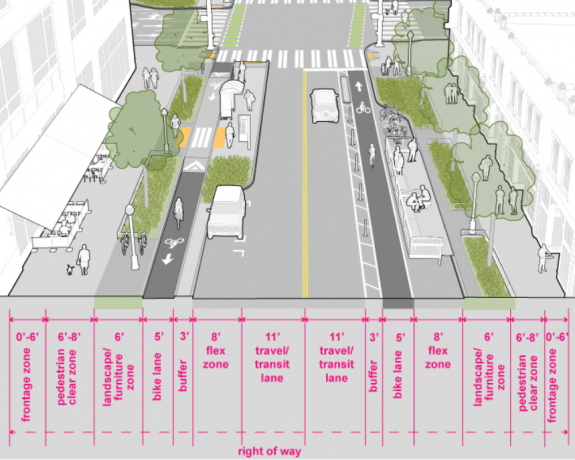
    Last Thursday SDOT held its final meeting with the Policy and Operations Advisory Group (POAG) and presented a finalized draft “modal integration policy framework”. We previewed this framework after the group’s last meeting in December. According to the department, it was developed to create policy guidance on integrating the bicycle, transit, freight, and pedestrian master plans. It focuses on areas where the right of way is “deficient”, meaning that according to SDOT’s own design standards (as laid out in its Streets Illustrated Right-of-Way improvement manual) there isn’t enough room to accommodate all modes on a specific city block. “Even with a large policy foundation, we lack comprehensive policy guidance for how accommodate these networks in places where the [street] is too narrow for all desired modes and uses,” the policy’s executive summary states.

    An image of street space allocation as recommended by the Streets Illustrated manual.

    That executive summary, which is the most detailed summary of the policy that we’ve seen so far, makes it even more clear that the adoption of this policy would specifically target the Bicycle Master Plan over the other modal plans. Across the three adopted modal plans (with the Pedestrian Master Plan analyzed separately), it cites 5,269 segments of bike lane, transit lane, or freight lane intended to fit within the space available from one curb to another. SDOT says 8% of them, or 440 blocks, are not wide enough to accommodate all of the modes specified as needing space in their respective plans. Amazingly, all but one of those 440 includes a planned bike facility. On half of those blocks (223), the bicycle facility is the only thing even competing for extra street space- no transit lanes or freight lanes are even conceived on those blocks.

    In other words, if the Bicycle Master Plan didn’t exist, there would be one block of conflict between Seattle’s modal plans over the use of the curb-to-curb space on our streets.

    In addition, there are another 1,208 street segments where a planned bike, freight, or transit lane fits in the street space only if a turn lane or a flex lane (parking, loading, peak hour travel) were removed. Again, this is almost entirely (598 of these) a bike facility all by itself. The policy states that flex lanes “in some cases, should be prioritized in right-of-way allocation decisions, and should be evaluated more consistently within concept design processes”.

    (more…)

    — Advertisement —
  • Trail Alert: 520 underpass in Montlake closed for two more weekends UPDATED

    UPDATE: the closure planned for February 5-8 is no longer happening due to a change in work. The highway will be closed but the pedestrian and bike trail will remain open. The next trail closures are February 26-March 1 and March 5-8.

    Aerial photo with the walking and biking path drawn on it.
    This connection will be closed for four weekends.

    The Washington State Department of Transportation is starting work on installing the Montlake freeway lid this weekend, the first of four weekend closures that will close the bike and pedestrian path underneath 520 from Friday at 11pm to Monday at 5am.

    These closures will be:
    January 29-Feb 1, 11pm to 5am
    February 26-March 1, 11pm to 5am
    March 5-8, 11pm to 5am

    Montlake Boulevard will be the primary choice for people biking to get between the Montlake Neighborhood and the Montlake bridge during the closure, though the Bill Dawson trail on the west side of Montlake Boulevard connecting to Montlake Playfield remains open. The pedestrian and bike trail across the lake adjacent to 520 will not close.

    You can watch a video from WSDOT explaining the work they are doing to create a lid over 520 at Montlake.


    — Advertisement —
  • Seattle continues to stagnate on preventing traffic deaths even as total collisions plummet

    Preliminary data on traffic collisions from last year shows that the total number of collisions involving people on bikes in Seattle was down by more than 50% compared to the average of the three previous years. This follows the trend in overall traffic crashes, which SDOT says went from 230 per week to 115 in 2020.

    One big footnote here is that this data is always unreliable; absolutely more so in 2020 as the number of people who would be hesitant to file a report with the Seattle police increased and the police side was more likely to deem something else a higher priority. But it’s the best we have to get a snapshot into what happened on our city’s streets last year.

    Even as traffic collisions fell, the overall number of people who lost their lives in traffic last year did not decline as well. Preliminary numbers show 24 people were killed in the year, as noted by the Seattle Times earlier this week, a number only matched in recent years by 26 fatalities in 2019.

    Zig zagging line starting at 23 in 2013 and ending at 24 in 2020

    Fourteen of the twenty-four people who were killed on Seattle’s streets last year were using our streets for walking or biking. This is a continuing trend, where a larger and larger percentage of fatalities are people using active transportation.

    The citywide reduction in speed limits on arterials that was put into high gear in the fall of 2019 is being cited as a success story by SDOT: they note a “20-40% drop in the number of crashes in locations with new 25 mph signs”, which they say was observed before the drop in traffic volumes seen last March. But that report only looked at North Seattle locations, and few high-crash corridors.

    At Rainier Ave and S Holly, where the Mayor unveiled the initial 25 mph sign at her 2019 press conference, an October 2020 speed study showed 91% of drivers in either direction were going above the speed limit, with 61% of drivers going over 30 mph on the street.

    Mayor Durkan pointing at a new speed limit sign
    Mayor Durkan unveils a 25 mph speed limit sign on Rainier Ave in 2019

    That lines up with data from another very frequent crash corridor, Aurora Ave N, which hasn’t seen speed limit changes recently but where data shows that drivers are frequently exceeding the speed limits. Both Rainier Avenue and Aurora Avenue saw traffic fatalities in 2020. All signs to point to more robust traffic design overhauls needed on Seattle’s busiest corridors, even if speed limit signs may have an impact on the less busy corridors.

    Statewide Washington saw higher traffic fatalities than it did in all but one year in the past decade: 560 people across the state died in traffic violence, or one approximately every sixteen hours in 2020. WSDOT Secretary Roger Millar has attributed this trend to people speeding, citing an individual driver going way over the speed limit in Snohomish County on I-5. But simply using one explanation ignores all of the areas of opportunity, including the ones laid out by WSDOT itself in its Active Transportation plan.

    Blue bars leading up since 2008 with 560 fatalities in 2020
    Year over year traffic fatalities were up 4.1% in Washington as a whole last year.

    Next month will mark six years since Seattle’s Vision Zero pledge, with not much to show for it. Washington State as a whole has been signed on to that pledge since 2000. We are heading the wrong direction, and it’s going to take real investment to change the dynamic.

    — Advertisement —
  • Local groups speak up in favor of protected bike lane on West Marginal Way

    The plan to finally connect the Duwamish Trail by installing a protected bike lane along the west side of West Marginal Way SW continues to face an uncertain future, as SDOT continues to conduct outreach before a final decision is expected later this Spring.

    Last week’s city Freight Advisory Board meeting devoted a considerable amount of time to the topic, after that board had sent a letter to the City in November that asked West Marginal Way “be restored as a five-lane facility”. In order to make that happen, the protected bike lane would have to not be installed, and the 2019 safety improvement that directs traffic into one lane southbound outside the Duwamish Long House would also need to be removed. At the meeting, the SDOT presentation showed exactly why removing that improvement- even after SDOT installs the planned pedestrian crossing signal at the Long House- is a bad idea. The curve in West Marginal at that point creates significant impediments to seeing traffic (often traveling around 40 mph) coming. So far we’ve seen no indication that the City is prepared to listen to the Freight Advisory Board and remove the lane reduction at any point in the future.

    Image showing side by side of sight lines at Alaska Street next to the Duwamish Longhouse, much better with the lane reduction

    During that meeting, we also got a look at the different options SDOT studied for extending the trail. The most discussed was Option A, which would have expanded the sidewalk that currently serves as the trail connection. This option would be much more expensive, not be as wide as a normal trail facility, require multiple trees to be removed, and also have sightline issues due to the driveways along the corridor. Option D, in the planter strip next to the railroad tracks on the east side of the street, also would be very expensive and require a new traffic signal to allow people to get back to the west side of the street. That’s true for option C as well, though that would utilize the entire easternmost lane, creating the same issues the freight board is concerned about. Option B, the one SDOT is still proposing, is the best option.

    Google maps view of Marginal with lanes marked with letters on them. West sidewalk A, west curb lane B, east curb lane C, east sidewalk D

    SDOT told the freight advisory board that the Duwamish Trail connection is expected to increase southbound travel times during peak hours by…ten seconds. Yet the board didn’t seem entirely placated by the data provided, with Chair Jeanne Acutanza calling the project an example of “death by a thousand cuts”.

    SDOT's preferred concept of the Duwamish connection, a PBL in the western lane of Marginal Way

    Last Friday, Duwamish Valley Safe Streets, West Seattle Bike Connections, and the West Duwamish Greenbelt Trails Group wrote a joint letter to SDOT Director Sam Zimbabwe expressing their support for the project as the department has designed it. In the letter, they push back on the arguments like those made by Freight Advisory Board members that removing a traffic lane for the protected bike lane would impact traffic on the corridor negatively. From the letter:

    “A significant benefit of the protected bike lane will be to improve traffic safety for all road users by slowing down speeding southbound traffic on West Marginal Way SW. Crashes are frequent and severe. Median speeds were in the mid-40’s and did not come down after speed limits were lowered to 30. Now speed radar signs are up, resulting in only about a 5 mph reduction. There is no congestion problem southbound due to lane capacity. There is a speeding and reckless driving problem, causing crashes and making it treacherous to cross on foot. Traffic congestion only occurs at the south end at the Highland Park Way intersection, where the backup from the First Avenue South Bridge begins. Along most of West Marginal Way SW, frantic drivers are rushing to get into the traffic jam as fast as they can. To hurry up and wait. Making more of the north end consistently one lane will allow drivers who travel at or near the speed limit to control the speed of all traffic, without any effect on throughput across the bridges. The bridges are the choke points, not the street.

    At the West Seattle Bridge Community Taskforce meeting earlier this month, Jolene Haas representing the Duwamish Tribe spoke in favor of the trail connection, saying, “It dovetails into the traffic revisions [at the Long House]…I don’t think it’s going to be a concern, it shouldn’t be.”

    SDOT is planning more outreach in February, including a mailer to West Seattle residents happening around now, as well as an online open house currently scheduled for the middle of next month. It’s a lot of engagement around a traffic lane that SDOT’s data shows is incredibly underutilized right now and providing little public benefit, but our eyes will be peeled for the next chance to speak up in favor of it.

    Calendar timeline stretching from Early January to Late March with decision point in April
    SDOT expects to make a final decision on the Duwamish trail connection by April.
    — Advertisement —
  • Quietly open: the first phase of the Central Ridge Greenway

    City crews are putting the finishing touches this week on a new Neighborhood Greenway on 18th Avenue in the Central District, the first phase in the long-planned Central Ridge Greenway. Along with the normal speed cushions and stop sign adjustments that come with most greenway improvements in Seattle, this corridor now has one of the best arterial diverters in the entire city, at 18th and Jackson Street.

    Map showing 18th Ave between Columbia and Weller Street in orange
    The first phase of the Central Ridge Route.

    The brand-new traffic signal at Jackson prohibits car traffic from continuing across the intersection with plastic barriers and posts, and includes automatic detection for cyclists at the designated waiting area. It also features a nifty light letting you know that you’ve activated the signal, though every time I’ve visited the intersection it’s been activated at all times (which works well also). It’s a clear contender for the best intersection upgrade in Seattle in the past couple of years.

    Right turn only boxes with separate place for a bike in front of diverter in the middle of the intersection
    18th and Jackson includes a really magnificent traffic diverter.

    The intersection of 18th and Yesler also includes brand new bike boxes with signal detection, no button pushing needed on this greenway, which is pretty great.

    Green bike box at intersection with traffic light in distance
    New bike boxes at Yesler and 18th.

    Between Cherry and Jefferson Street, 18th hasn’t gotten any upgrades yet, but a planned expansion of Swedish Hospital to the east will be including streetscape improvements. These unfortunately fall short of making real traffic calming on the greenway, missing a unique opportunity to really create an amazing streetscape that isn’t centered around traffic driving through the block.

    Construction is just ramping up on the hospital expansion so it will be a while before those changes are fully implemented.

    Current view of 18th next to Swedish which is planned for streetscape upgrades.
    Narrower roadway with added greenery and a new five foot sidewalk to access parked cars.
    Planned streetscape changes at Swedish, which do not change much about the dynamics of the block.

    Extending the greenway north to Volunteer Park, in phase 2, has run into funding difficulties. SDOT now says that they do not have enough funds to construct the entire project, and have asked the Move Seattle levy oversight committee for permission to divert that funding to the Stay Healthy Streets program. The pedestrian and the bike advisory boards voted against that earlier this month. That doesn’t mean nothing is planned north of Columbia.

    The Madison RapidRide project will be installing a new signal across Madison Street at 18th Ave, one of the highest-stress points on the current route. Currently there are no markings whatsoever across the expanse of Madison here, and sightlines aren’t great. Adding a new crossing here will be the biggest improvement that would come with the next phase of the greenway. The intersection with Union Street is also getting improvements as part of the planned protected bike lane later this year.

    Crosswalks and sidewalk improvements planned for Madison and 18th
    Upgrade to Madison and 18th planned with the RapidRide project.

    18th Ave north of Columbia already has some existing greenway elements, including chicanes installed in previous decades. And a Neighborhood Street Fund project a few years ago added curb extensions and a marked crosswalk to the intersection with Thomas Street.

    Bulbout in middle of street with yellow and black warning signs
    Chicane on 18th Ave south of Union St.

    Last year, SDOT constructed a Neighborhood Greenway that mostly uses E Republican Street to connect Meany Elementary School and Lowell Elementary School as a Safe Routes to Schools project.

    Map showing greenway connecting Lowell Elementary and Meany Middle School
    A greenway on E Republican Street was installed in 2020.

    We could be getting creative about completing the Central Ridge’s route to Volunteer Park. If the greenway was routed onto 14th Ave rather than 16th, using the Republican greenway, the project could take advantage of a Your Voice Your Choice project that is already adding flashing crossing beacons at the arterial crossing of Aloha Street.

    Ultimately though, the upgrades that are still planned for this route will make the biggest difference, turning what was already a pretty popular route into a better connection to the King Street greenway and now the bike lanes across the Jose Rizal bridge to Beacon Hill.

    — Advertisement —
  • Latest segment of 7th Ave bike lane opens in Denny Triangle

    One way protected bike lane with Amazon campus in background

    The latest block of sidewalk-level one way protected bike lane has opened on 7th Ave in the Denny Triangle, which means that bike lane now runs southbound all the way from Bell Street to Pike Street downtown. There’s also a northbound bike lane, running between Bell Street and Westlake Avenue, which has been open since the end of 2019.

    This is the final block of bike lanes added in conjunction with new buildings in Amazon’s Denny Triangle campus expansion, most of which were installed as part of a public benefits agreement reached over permission to permanently develop the public alleyways on those same blocks.

    The Amazon buildings in Denny Triangle that provided the sidewalk level PBLs

    But it’s not the final sidewalk-level PBL planned for 7th. Another building being developed by Onni north of Bell Street will also include a southbound bike lane. When that’s complete in a few years nearly the entire route between Denny Way and Pike will be grade-separated.

    Rendering of the planned Onni development between Bell and Battery which will complete the 7th Ave southbound PBL

    As for that northbound segment, it’s a bit disjointed. 8th Avenue is the northbound route that connects with downtown, but there are numerous places north of Westlake where it loses any protection from traffic and where drivers can enter and exit the bike lane to use the parking lane. But there’s no easy way to transfer from 8th at Westlake to the 7th Ave sidewalk level PBL. Riding on the sidewalk isn’t really an option. And so the protected facility remains a block away from where it needs to be.

    Bike lane with armored truck in it, and parking next
    The protected bike lane on 8th Avenue stops being protected north of Westlake.

    There are definitely strong feelings around the sidewalk-level bike lanes on 7th, which happened to open just as Amazon was trying out its Amazon Go convenience store concept, generating a lot of foot traffic that ended up spilling into the bike lane. While foot traffic has obviously decreased in the past year or so with most of the Amazon campus quiet, the design of the bike lane absolutely encourages slower travel than a street level lane, and doesn’t really encourage side-by-side riding.

    Perhaps the best aspect of these bike lanes is that they have allowed the city to expand the all-ages network without using much direct city money. As more people begin to return to work downtown in 2021, having these in place will make a lot of people’s downtown trips more enjoyable.

    One way bike lane and lean rails next to the Amazon spheres

    — Advertisement —
— Advertisement —

Join the Seattle Bike Blog Supporters

As a supporter, you help power independent bike news in the Seattle area. Please consider supporting the site financially starting at $5 per month:


Latest stories

Bike Events Calendar

Jul
25
Thu
7:15 pm Point83 @ Westlake Park
Point83 @ Westlake Park
Jul 25 @ 7:15 pm
Point83 @ Westlake Park
Meet up in the center of the park at 7ish. Leave at 730. Every Thursday from now until forever rain or shine. Bikes, beers, illegal firepits, nachos, bottlerockets, timetraveling, lollygagging, mechanicals, good times.ShareMastodonTwitterFacebookRedditEmail
Jul
27
Sat
all-day Bicycle Weekends on Lake Washing…
Bicycle Weekends on Lake Washing…
Jul 27 – Jul 28 all-day
Bicycle Weekends on Lake Washington Blvd
Details from Seattle Parks: On scheduled weekends from May to September, a portion of Lake Washington Boulevard will be closed to motorized vehicles from 10 a.m. Saturday to 6 p.m. Sunday. “Seattle Parks and Recreation[…]
Jul
28
Sun
all-day Bicycle Weekends on Lake Washing…
Bicycle Weekends on Lake Washing…
Jul 28 – Jul 29 all-day
Bicycle Weekends on Lake Washington Blvd
Details from Seattle Parks: On scheduled weekends from May to September, a portion of Lake Washington Boulevard will be closed to motorized vehicles from 10 a.m. Saturday to 6 p.m. Sunday. “Seattle Parks and Recreation[…]
Aug
1
Thu
7:15 pm Point83 @ Westlake Park
Point83 @ Westlake Park
Aug 1 @ 7:15 pm
Point83 @ Westlake Park
Meet up in the center of the park at 7ish. Leave at 730. Every Thursday from now until forever rain or shine. Bikes, beers, illegal firepits, nachos, bottlerockets, timetraveling, lollygagging, mechanicals, good times.ShareMastodonTwitterFacebookRedditEmail
Aug
8
Thu
7:15 pm Point83 @ Westlake Park
Point83 @ Westlake Park
Aug 8 @ 7:15 pm
Point83 @ Westlake Park
Meet up in the center of the park at 7ish. Leave at 730. Every Thursday from now until forever rain or shine. Bikes, beers, illegal firepits, nachos, bottlerockets, timetraveling, lollygagging, mechanicals, good times.ShareMastodonTwitterFacebookRedditEmail
— Advertisements —

Latest on Mastodon

Loading Mastodon feed…