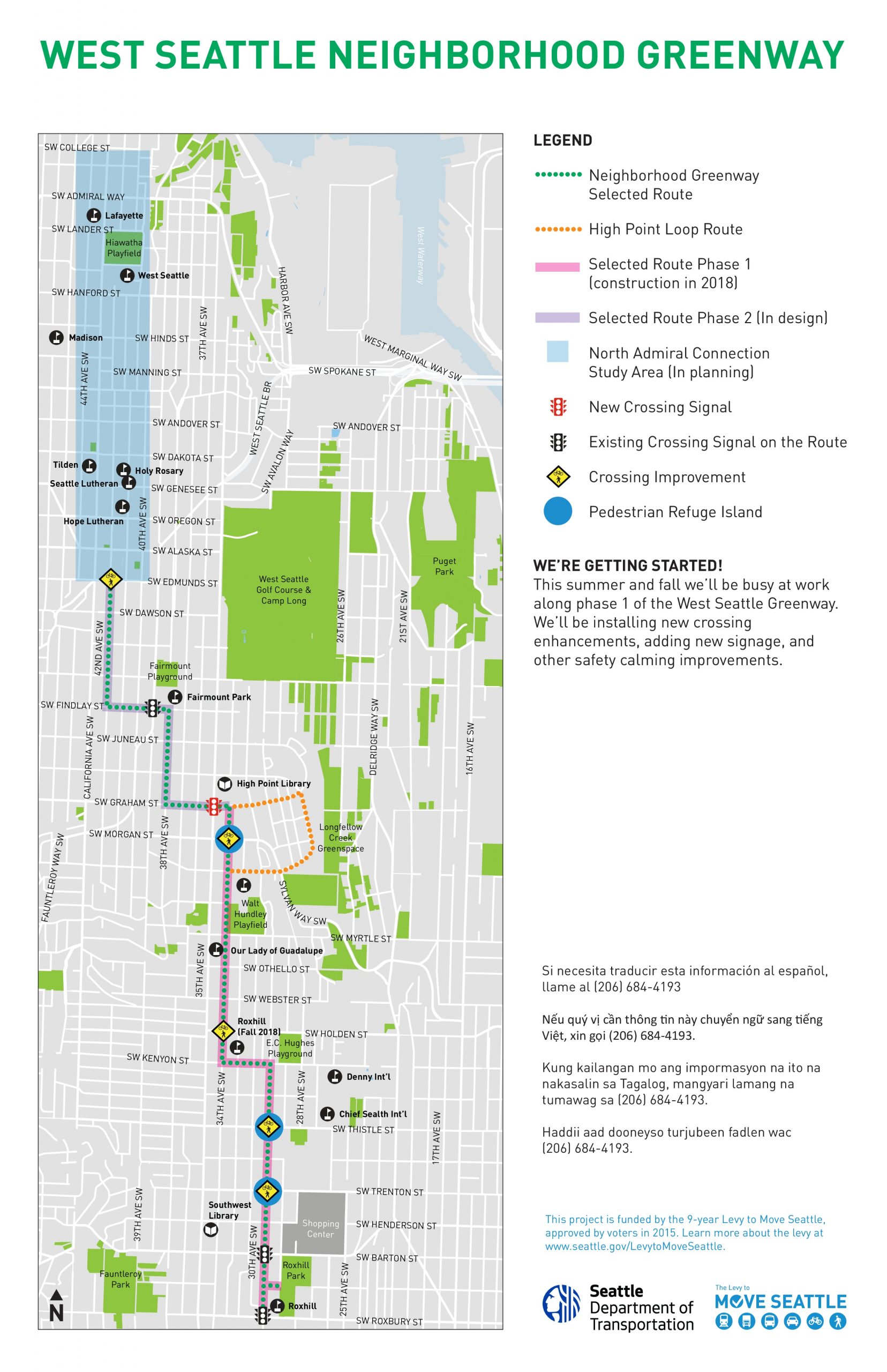
This month SDOT says they are starting work on an extension of the West Seattle Neighborhood Greenway, which will finally connect the current greenway in the south end of the neighborhood with Alaska Junction. Most notably, the project will bring a major redesign to one of the area’s most problematic intersections, 35th Ave SW and SW Graham Street.
Map of the ultimate West Seattle Greenway, with the 2021 portion colored in green (click to enlarge).
Several high profile traffic deaths have occurred at the intersection of 35th and Graham. It’s been seven years since James St. Clair was struck and killed while attempting to cross the intersection on foot, and fourteen years since Susanne Scaringi was killed while biking across it. There’s not really any good excuse as to why safety improvements at this spot have taken so long to get constructed.
This project was most recently slated to go in last year, but was delayed due to “administrative challenges, most notably waiting longer than anticipated to receive the final approval for grant funding”. I asked SDOT spokesperson Ethan Bergerson if the new signal here would be a priority due to past issues here, and he told me, “We haven’t determined the construction schedule or order in which improvements will be installed. Safety will definitely be one of the factors which we consider.”
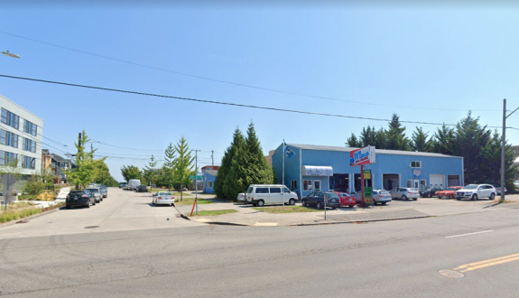
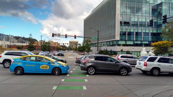
Currently 35th and Graham is a huge intersection to get across.
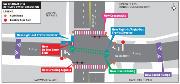
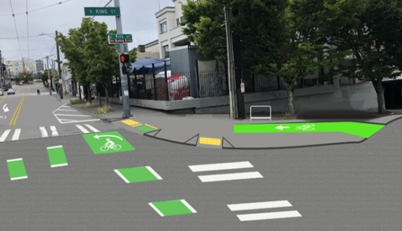
The planned upgrade to 35th/Graham includes a signal for traffic on 35th, marked crosswalks and a green crossbike for traffic on Graham, and traffic restrictions that essentially amount to a diverter- drivers will not be able to go straight across the intersection on Graham Street, and a left turn from 35th will only be allowed onto eastbound Graham, not westbound.
Plans for the greenway crossing at 35th and Graham include a new signal and diverter.
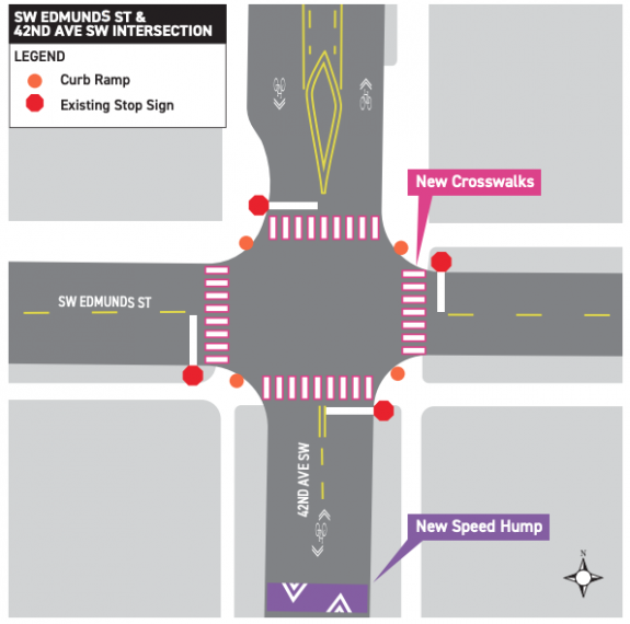
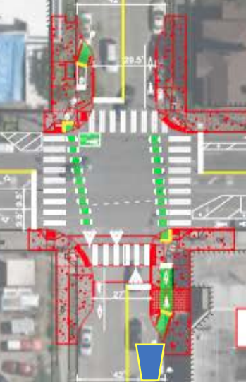
The entire extension of the Greenway will be installed on SW Graham Street, 38th Ave SW, SW Findlay Street, and 42nd Ave SW where it will terminate at SW Edmunds Street. The route only includes one other signalized crossing, at Findlay and 39th. At Edmunds, the existing four-way stop will be upgraded with new marked crosswalks.
42nd and Edmunds will get marked crosswalks.
The end of the West Seattle greenway is ultimately envisioned in the Admiral District, and SDOT currently has funds to design and plan that extension to the north but not to construct it. Heading through Alaska Junction on 42nd, traffic volumes on the street are higher than they would be on a normal neighborhood greenway, so the street treatments will have to be a bit more robust.
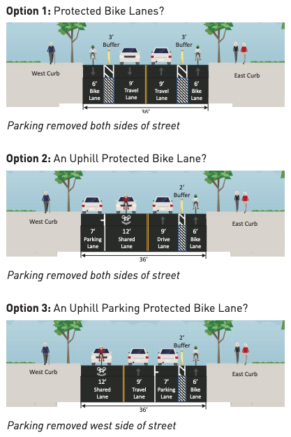
Designs from 2018 show a few different options to make the Junction segment more welcoming to people on bikes, the tradeoffs between them being parking, so we should expect that discussion to restart.
Options being considered for 42nd Ave SW in the junction.
A portion of this existing greenway in High Point is currently functioning as a Stay Healthy Street, with pedestrians and people biking more able to utilize the street space. In the coming weeks we’ll learn if SDOT has selected this route, serving one of the most diverse areas of West Seattle, to be one of the twenty miles of permanent Stay Healthy Streets and to get the permanent traffic diversion improvements that are going to come along with that. Ideally all neighborhood greenways would enable users to feel as comfortable using them as a Stay Healthy street does.
You can read more about the plans for the 2021 expansion of the West Seattle neighborhood greenway at SDOT’s blog.
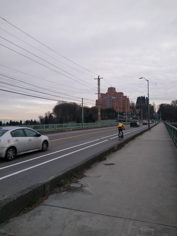
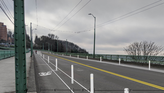
The painted bike lane is now in place on the Dr. Jose P Rizal Bridge on 12th Ave S, a big construction milestone in the 12th Ave Vision Zero project, which is creating a bike connection between Little Saigon and the Mountains to Sound Trail at the north end of Beacon Hill. Still to come: plastic delineator posts in the buffer between the bike lane and the other travel lane.
Still to come: posts.
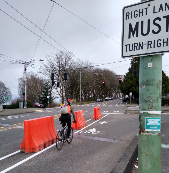
With the bike lane comes the vanquishment of one of Seattle’s most treacherous slip lanes, at Golf Drive on the west side of the street. As of this week, it is no more, with drivers directed to make a square right turn at the pedestrian island. This should make everyone not in a car more comfortable at this intersection.
Golf drive slip lane no more!
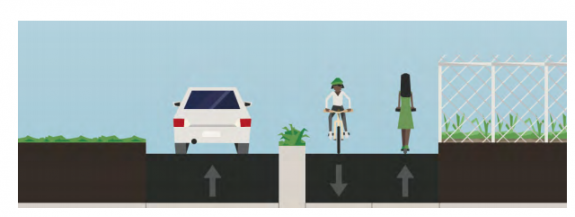
The biggest thing left to complete is work at north end of the PBL, at King Street. The curbs are being rebuilt at two of the corners right now to extend them out, at the spots where people biking would wait for the light to change across 12th, providing a protected spot at sidewalk level to wait for the light.
The protection for people riding bikes at the intersection of 12th and King.
The left turn lane from northbound 12th onto King Street toward downtown is being eliminated, with the turn lane and a protected turn phase being moved one block north to Weller St- that one’s already in place. That gets rid of a dangerous turn movement at the connection between protected bike lane on 12th and “neighborhood greenway” on King St.
Plans for S King Street and 12th Ave S.
As of now, there are no plans to extend the bike lane any further north than King Street, despite the high number of people biking who use that route.
Expect to see work being done in the coming weeks to add the plastic posts, and finish the work in Little Saigon, but the lane is open, and it’s currently getting a lot of use as people biking who previously had to contend with impatient drivers on the bridge now have their own space.
Later this year we’ll get more details on the next phase of this protected connection, the Beacon Hill bike route planned for construction in 2023.
Rep. Jake Fey, chair of the House Transportation Committee
Correction: a previous version of this post listed the timeframe of this package at 12 years instead of 16.
Yesterday the Democratic caucus in the Washington State House announced their proposal for the next major state transportation package. Their proposal would raise over $26 billion dollars over a sixteen-year period and include a brand-new carbon fee, the proceeds of which would be directed to a host of “carbon reduction initiatives”, including unprecedented state spending on multimodal transportation.
The proposed spending includes:
$267 million for direct bike & pedestrian projects
$318 million for bike & pedestrian grants to local governments
$290 million for Safe Routes to School grants
$59 million in Complete Streets grants
$333 million in transit grants
$800 million in bus & bus facility grants
$960 million in special needs transit grants
$240 million in rural mobility transit grants
$200 million in green transit grants
$80 million in tribal transit grants
That works out to over $80 million for every 2-year state budget in active transportation grants alone distributed to counties and cities statewide, to say nothing of the grants for public transit. This would amount to a big shift in transportation spending away from being primarily focused on highways and ferries alone.
The direct investments at the state level in bike & pedestrian projects should hopefully take some of the recommendations of the state’s Active Transportation plan and put them into action. You can read a full breakdown of the known spend plan here.
At the same time that a progressive carbon tax is proposed to fund projects that will decarbonize and electrify transportation, the package also proposes a black box of $6.7 billion in new “state & local projects”. These are likely new highway projects, but the only project we know about for certain right now is the proposed replacement of the I-5 bridge between Washington and Oregon, which would receive $1 billion. The total $3.2 billion price tag for that project is so high in part because of the amount of added capacity that is likely to come with it. The rest of the projects in the black box are expected to be negotiated via the legislative process later this session.
The proposal would also direct a much higher amount of money toward preserving and maintaining current transportation infrastructure than we’ve seen in recent years, with $4.6 spent to reduce the maintenance deficit over 16 years. It would also spend $3.5 billion to fully remove fish culverts statewide in compliance with a court order.
The funding for highway expansion and maintenance would be funded by a gas tax increase, bringing Washington up to 85 cents per gallon, the highest in the country. The proposal would also index the gas tax to the consumer price index, allowing it to better keep up with inflation.
This transportation package takes Senator Rebecca Saldaña’s proposed package from the State Senate side, which would make $2 billion in multimodal investments over twelve years, and takes it to the next level. But it may run into opposition from other Democrats in the Senate who want to see a transportation package focused even more around highway expansion. But this is clearly the new bar for a progressive transportation package, at least on the House side- one that recognizes we need to massively scale up our multimodal investments. In the coming weeks we’ll see how much traction the proposal is able to gain.
Representative Sharon Shewmake, 42nd Legislative District
A bill introduced into the Washington House of Representatives by Representative Sharon Shewmake (D-Bellingham) would exempt electric bikes, and up to $200 in bike accessories, from state sales taxes. HB 1330 would not apply to non-electric bikes, using the definition of ebike in state law, “bicycle with two or three wheels, a saddle, fully operative pedals for human propulsion, and an electric motor. The electric-assisted bicycle’s electric motor must have a power output of no more than seven hundred fifty watts”.
On Twitter, Rep. Shewmake explained her reasoning for confining the legislation to ebikes:
“My thinking was e-bikes are emerging tech and a car replacement. Haul kids, handle hills, more groceries! We give tax breaks to EVs but not e-bikes which are cheaper, don’t take up as much space, use less electricity, are FUN and a LOT cheaper but still suffer from sticker shock.”
As written, the exemption would take effect on August 1st of this year, and expire in 2027 or if $500,000 in sales taxes have been waived under the provision, whichever comes first. However, there’s also a provision that signals the intent of the legislature to extend the exemption if it’s successful, specifically if sales of ebikes go up 25% or more compared to 2020 levels.
Bike accessories that qualify for the exemption (up to $200) are defined as “cycling accessories commonly associated with bicycle ownership including, but not limited to, helmets, bicycle locks, fenders, lights, and a bicycle service or repair plan, purchased as part of the same transaction as an electric bicycle”.
This bill would be an easier pathway to providing a state-supported boost to ebike ownership than a frequently-discussed rebate program (which we should also be pursuing). The transportation package floated during the 2020 session actually included a special sales tax on bikes, which would match a similar fee passed in Oregon in 2017, but so far we’ve seen no indication that a transportation package in either legislative house will include a special bike tax.
To stand a chance getting through the legislature, the bill currently needs co-sponsors. Contact your local House members to ask them to add their name to HB 1330.
SDOT has released a study looking at how to improve access for people walking and biking around two coming light rail stations at the north end of the city. The station in Shoreline at 148th Street is currently planned to open with the Lynnwood Link extension in 2024, and the planned infill station at 130th Street was originally scheduled for 2031, but this year the Sound Transit board will be voting on whether to move that up to 2024 so that they open at the same time.
This is the result of community engagement since 2019 being headed up by Seattle’s Office of Planning and Community Development, in conjunction with land use changes in the surrounding neighborhoods.
The study includes a current map of “level of traffic stress” for people biking around the vicinity of both stations. It has a lot of red, including a segment of pretty much every east-west route someone would use to access either station. The only separated bike facilities are the Interurban trail, pretty far away from the I-5 corridor where the train stations are, and a loosely protected bike lane on Pinehurst Way. The red on the map underscores the fact that there isn’t much of a bike network, and that we have a lot of work to do.
“Level of traffic stress” map for the area around these two light rail stations. (Click to enlarge)
This gets ahead of the planning for station access at these stations, but the projects “will still need to compete for transportation funding resources” from sources like the next transportation levy (starting in 2025, if it passes) or Sound Transit’s station access fund. The study also says “we encourage the community to pursue other available funding sources identified in the City of Seattle’s Community Resource Guide”, aka finding your own funding sources to improve access to light rail stations.
All of these projects will be built on top of the improvements coming directly at the stations themselves. NE 130th Street station is currently planned to have a ten foot “shared use path” directly outside the station running along 5th Ave NE between 130th and 145th Street. This will be the only pedestrian access between these two streets except for the pedestrian trail that exists on the edge of Jackson Park golf course, which is not fully accessible. The I-5 side of 5th Ave NE will not have sidewalks; riders who get off the trail will meet a dead-end at the north end of the station exit.
Planned “shared use path” on 5th Ave NE in front of 130th Street Station
Shoreline is currently planning to build a pedestrian and bicycle only bridge across I-5 to connect with the station at NE 148th Street. That bridge will connect via trail with 1st Ave NE but it doesn’t look like there will be any bike facilities on that street, with riders directed to the “off-corridor bike network” in Shoreline, aka neighborhood greenways. 5th Ave NE directly outside the Shoreline station also won’t have any bike facilities, according to the most recent plans.
Planned bike & pedestrian bridge across I-5 at NE 148th Street in Shoreline
As for the study itself, the projects that were ranked highest in the study are likeliest to be prioritized, tier 1 projects were defined as “provid[ing] direct access to the future stations; the rest of the network builds on these projects.” In other words, if these projects aren’t complete or in progress by the time the station opens, we will have missed a big opportunity.
So what are the highest-ranked projects in the study?
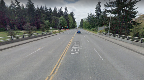
Improve the I-5 crossing at 130th Street with a shared use path
Current state of N 130th Street
Unsurprisingly, one of the top improvements here is to remake the bridge over I-5 at 130th Street which is currently four travel lanes and fairly narrow sidewalks. The recommended treatment here is a shared use path on the north side of the street (the light rail station will be completely on the north side).
A shared use path is proposed for the north side of NE 130th Street. (Click to enlarge)
Extending the shared-use path all the way to Aurora Ave is looked at as a separate project, but a neighborhood greenway on N 128th Street is also cited as an alternative. “This option would reduce conflicts between transit and bikes on N 130th St” is perhaps the wrong way to think about that.
145th improvements
145th Street is a state highway between Aurora Ave and Lake City Way, SR-523. Shoreline is taking the lead on street improvements on the corridor, with the latest proposal adding two roundabouts to the intersections on either side of I-5 at 145th, 1st and 5th Ave. The only bike facility currently proposed for the corridor would be a short stretch of shared-use path on the north side of the bridge over the interstate.
Current early plans for I-5 at 145th Street. (Click to enlarge)
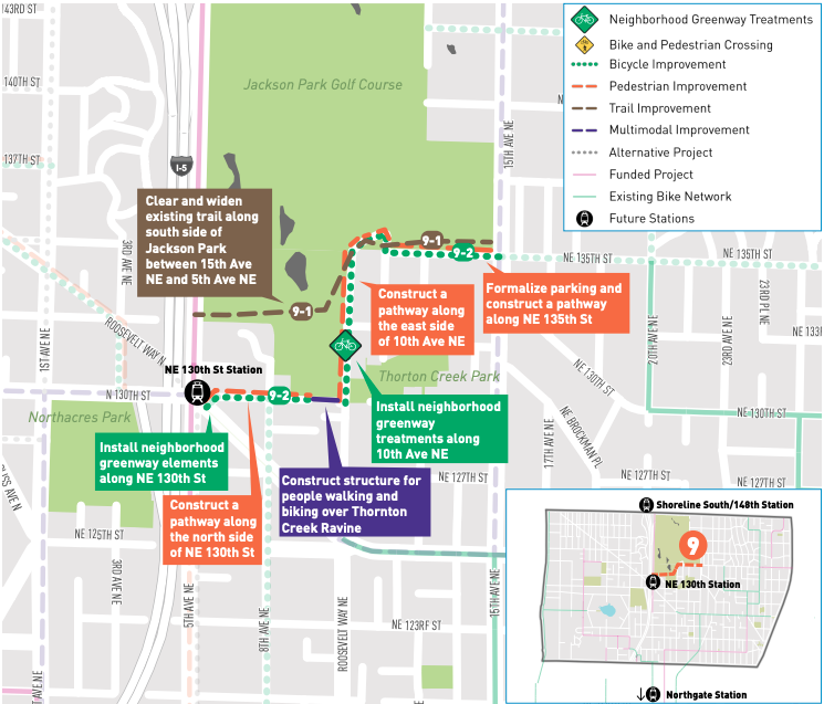
The top rated projects on the Seattle side for 145th are almost entirely all crossing improvements. Improvements to the sidewalk adjacent to Jackson Park golf course were also included- there the sidewalk is frequently encroached on by vegetation and utility poles, and it’s just an unpleasant place to walk. That sidewalk is the only way to complete a full loop around the golf course.
Jackson Park trail improvements
On the southern end of Jackson Park golf course, the trail cutting east to west will be a frequently used pathway for people accessing the light rail station at 130th, with or without improvements to it. The most likely improvements are to widen the existing trail that connects with 5th Ave NE. But SDOT is also considering reclaiming right-of-way that doesn’t currently exist along 10th Ave NE to create a connection between Jackson Park and 130th Street. This could include neighborhood greenway elements and separated pedestrian facilities.
A number of projects could improve access to 130th Street Station via the Jackson Park trail. (Click to enlarge)
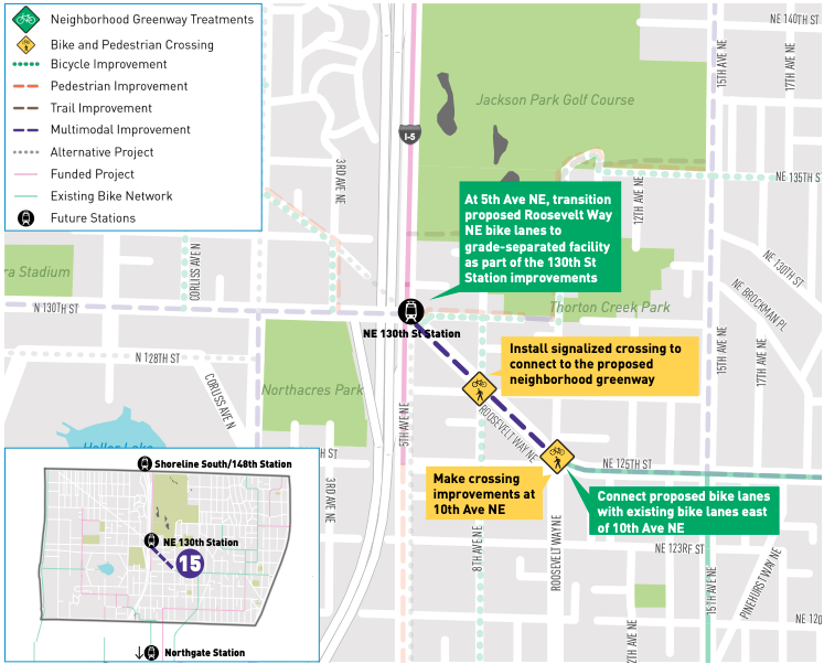
NE 125th Street and Roosevelt Way redesign
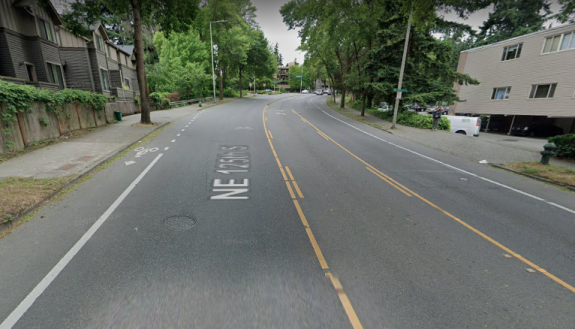
Roosevelt Way NE is a diagonal street connecting directly between 125th and 130th Street at the proposed light rail station. 125th currently has paint bike lanes, but they disappear at Roosevelt Way (as well as in the other direction before Lake City Way).
NE 125th Street currently has painted bike lanes only.
This project would install protected bike lanes between 125th and 130th, and take the number of general purpose lanes on Roosevelt down from four to three. This would really improve bike access between the station and the heart of Lake City.
Protected bike lanes could be added to Roosevelt Way NE. (Click to enlarge)
Seattle is really good at creating plans, and there’s a lot of great ideas in this study for making it easier to get around the vicinity of these light rail stations, at least one of which is opening in just a few years. Identifying funding sources is pretty important to getting these actually built, but it’s likely there will be a lot of competition for those pots of money when they become available. Most of these projects are pretty essential in getting the most out of the billion-dollar light rail investments that our region is making, and we should treat them that way.
You can read the entire Station Access Study which includes many more proposed projects at SDOT’s blog.
As of this past Monday morning, SDOT has turned on the automatic cameras that are able to ticket drivers $75 who aren’t authorized to use the Spokane Street drawbridge between 5 am and 9pm. This is great news for transit riders who cross the bridge and other essential workers allowed to use it. That day also marked seven months since the law the state legislature authorized allowing automatic enforcement of restricted lanes went into effect, and over nine months since it was signed by the Governor.
The pilot program also allows Seattle to issue automatic tickets to drivers who block an intersection or a crosswalk at up to twenty locations “where the Seattle Department of Transportation would most like to address safety concerns”, per the ordinance that the city council passed last year. But the city can only pilot those cameras until June 30 2023, meaning less than 30 months remain in the pilot, and we still don’t know what that list of camera locations is going to be.
Mercer and 9th Ave N is a busy bike corridor that is frequently impacted by drivers blocking the box.
SDOT spokesperson Ethan Bergerson told me that the agency hasn’t determined a list of camera locations yet, nor was he able to provide an estimate of when any crosswalk enforcing camera locations might be announced.
When the law authorizing a pilot program was before the legislature, a large portion of the contingent that showed up to support it was pushing for that crosswalk enforcement element, to improve safety for everyone and improve mobility for people with disabilities for whom blocked crosswalks often mean harrowing detours. Without those voices working together with transit advocates pushing for the tools to enforce bus-only lanes, it’s likely there would be no pilot program at all.
The legislature had been considering an automatic camera bill with a crosswalk component since January of 2019, with a transit lane bill also before the legislature in the 2018 session and discussed by legislators well before that. It is surprising that a list of locations was not ready to go.
The pilot program requires a report to be delivered to the legislature by June 30 of next year. Assuming a few months of process and outreach for a brand new type of enforcement camera, it’s possible that the initial report may barely include a year of data on crosswalk enforcement. The renewal of this program, or its being made permanent, would be one necessary step in reducing the role of in-person traffic enforcement. Without making this change permanent, Seattle can only enforce red lights, railroad crossings, and speeding outside schools during specific times with automated cameras. But first, the pilot program needs to be successful. For that to happen, it needs to begin.
Meet up in the center of the park at 7ish. Leave at 730. Every Thursday from now until forever rain or shine. Bikes, beers, illegal firepits, nachos, bottlerockets, timetraveling, lollygagging, mechanicals, good times.ShareMastodonTwitterFacebookRedditEmail
Details from Seattle Parks: On scheduled weekends from May to September, a portion of Lake Washington Boulevard will be closed to motorized vehicles from 10 a.m. Saturday to 6 p.m. Sunday. “Seattle Parks and Recreation[…]
Details from Seattle Parks: On scheduled weekends from May to September, a portion of Lake Washington Boulevard will be closed to motorized vehicles from 10 a.m. Saturday to 6 p.m. Sunday. “Seattle Parks and Recreation[…]
Meet up in the center of the park at 7ish. Leave at 730. Every Thursday from now until forever rain or shine. Bikes, beers, illegal firepits, nachos, bottlerockets, timetraveling, lollygagging, mechanicals, good times.ShareMastodonTwitterFacebookRedditEmail
Meet up in the center of the park at 7ish. Leave at 730. Every Thursday from now until forever rain or shine. Bikes, beers, illegal firepits, nachos, bottlerockets, timetraveling, lollygagging, mechanicals, good times.ShareMastodonTwitterFacebookRedditEmail