
Tom returns tomorrow…
By
| Posted
— Advertisement —
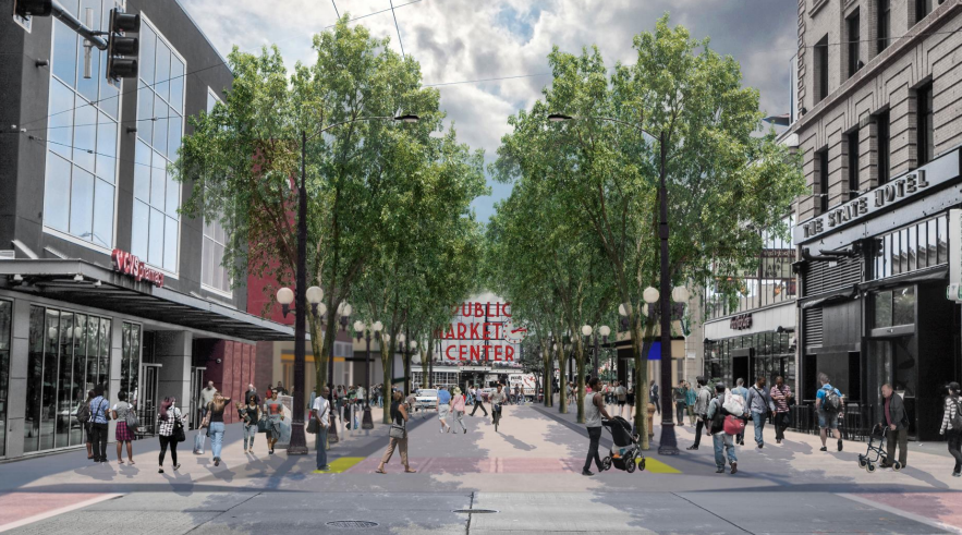
What the transformation of Denny Way tells us about our city
By
| Posted
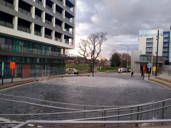
Last week, five years after Capitol Hill’s light rail station opened, the construction fencing was finally removed on the long-planned public plaza that will complement the south entrance of the station next to Cal Anderson Park. It’s a truly great new gathering space for a neighborhood that’s always been short on park land, and it’s very much like an extension of Cal Anderson Park just opened.

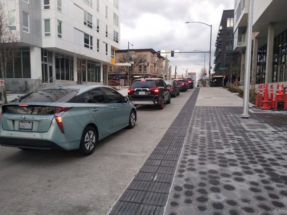
But the new public space was overshadowed: the plaza’s opening highlighted the fact that the redesigned stretch of Denny Way in front of the station is not functioning as it should. Despite the fact that this segment of street was closed for six years to construct the light rail station, it’s back to being a regular part of the street grid, albiet only one-way. And nothing was installed to prevent drivers from entering the public plaza, much less the pedestrian-oriented areas of the street itself.
Brie Gyncild is one of the driving forces in the Capitol Hill Champion volunteer group, a joint project of the Capitol Hill Community Council and the Capitol Hill Chamber of Commerce that was devoted to achieving community goals for the development of the light rail station site. “Originally, the community vision was for that street to be a pedestrian-first street”, she told me. A permanent closure of the space to vehicles wasn’t ever on the table, but the design of the street was supposed to ensure that any vehicle traffic would be going very slow.
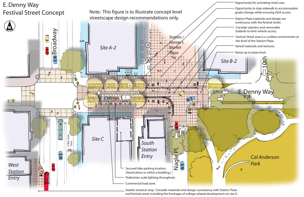
Indeed, the 2011 Urban Design Framework for Capitol Hill Station outline how the goals for the Denny Way festival street should include being “pedestrian and bicycle focused”, and having “limited access for local circulation and commercial load zones”. An illustration of the festival street concept from the same framework includes a notation to “consider planters and removable bollards to limit vehicle access”. In 2016 when the station opened, SDOT closed down the street when the National Association of City Transportation Officials (NACTO) was in town, for games of Scrabble, but almost exclusively in the years since the station opened Denny Way has been open to vehicle traffic. A festival street designation is not the same thing as a festival street design.

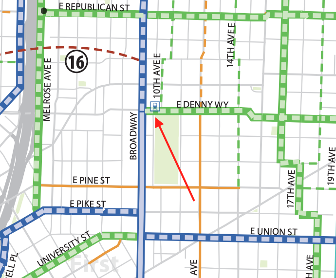
2011 Design Framework for the Denny Way festival street in Capitol Hill (Click to enlarge) Central Capitol Hill, almost certainly with the help of the light rail station itself, has seen a remarkable 31% drop in the number of cars per resident in the past 10 years, per the Seattle Times. Here’s an instance where going the extra mile to make a block pedestrian and bicycle oriented will not cost us very much compared to any other option, and could have a reverberating effect throughout the neighborhood. Denny Way has long been envisioned as the location of a neighborhood greenway in a dense neighborhood with few east-west bike routes planned. Yet the greenway project has been delayed numerous times. In the center of the planned bike network for the area, vehicle access remains the priority.

Central Capitol Hill as envisioned in the 2014 Bicycle Master Plan. Denny and Broadway rests at the center of the planned network. (Click to enlarge) Denny Way is only one example, but there are countless other examples of prioritizing access for a limited few and sacrificing the benefits that could come from turning space for cars into space for people. The renderings of Pike and Pine Street between 1st and 2nd Aves planned as part of the Pike Pine Renaissance show another “shared street” with people walking across the roadway freely but without any barricades to prevent drivers from speeding through the space. We know if this was converted into another Occidental Avenue, with business and emergency access preserved, that it would become a beloved public space. And yet we won’t do it.

Concept drawing for Pike Street between 1st and 2nd Ave as part of the Pike Pine Renaissance Project. In West Seattle, plans are moving forward for a pair of twin apartment buildings on a designated bike corridor, 36th Ave SW south of Fauntleroy. It’s not a major arterial, and yet the street concept that goes before the design review board in coordination with SDOT includes 20 feet of roadway space, and 23 feet of parking, including back-angle parking. The bike facility proposed as Seattle careens toward 2030 completely off track to hit its carbon reduction targets is…sharrows. Even the Southwest Design Review board is trying to push back on that, with its meeting report noting,”The Board noted the street improvements would still create a car centric street, with parking on both sides of the street and wide car travel lanes.”

Street concept plan for 4406 36th Ave SW. (Click to enlarge) The city’s new report outlining its ambitious transportation electrification goals generated headlines. Seattle has an entire department in Seattle City Light that is very invested in supporting the transition to more broad availability of electric vehicle infrastructure. But when it comes to making decisions that will support the necessity of the city as a whole to reduce the amount of vehicle miles that Seattle residents travel, on an institutional level Seattle is still sticking with the status quo.
tags: pedestrian space— Advertisement —
Person on bike struck and killed by driver in Georgetown collision
By
| Posted
Just before 5pm Wednesday evening, someone riding a bike was struck and killed by the driver of a semi-truck in the Georgetown neighborhood, according to the Seattle Police Department. The collision took place at the intersection of Corson Ave S and S Michigan Street, which turns into S Bailey Street east of Corson. From SPD:
Prior to the collision, the driver of the semi-truck was stopped facing northbound at the intersection of South Michigan Street and Corson Avenue South, preparing to make an eastbound right turn [onto Bailey Street]. As the driver waited at the light, a bicyclist that had also been travelling [sic] northbound pulled in front of the truck, apparently out of view of the driver. When the truck pulled forward to turn right, the bicyclist was struck and killed.
The person riding the bike was approximately 40 years old, according to the department.
The curb ramp from Corson onto Bailey has a very large apron to accommodate the wide turning radius of large freight trucks that travel through the area. Georgetown has received a much larger volume of vehicle traffic since last March when the high West Seattle Bridge was entirely closed, though the low bridge remains open to freight traffic. The semi truck on SDOT’s traffic camera showed a visible USPS logo. There is a USPS distribution facility not far from Georgetown in Tukwila, and a USPS vehicle maintenance facility in SoDo.

Corson Ave S and S Bailey St (Google Maps) Collision at Corson Ave S and S Bailey St. All EB lanes are closed. Use alternate routes. pic.twitter.com/xukxQd2eh2
— SDOT Traffic (@SDOTtraffic) March 24, 2021
This is at least the sixth traffic fatality on Seattle’s streets so far in 2021 and the first we know of where someone involved was riding a bicycle.
We are heartbroken at this news, and are thinking about what this person’s family and friends must be going through right now.
tags: traffic violence— Advertisement —
Safety, maintenance compete for slice of council-approved car tab revenue
By
| Posted
The Seattle Department of Transportation has released its proposed spending plan for the proceeds from a $20 vehicle license fee (VLF) that the City Council approved last fall. After an outreach process where the department received feedback from around 20 organizations and boards, it’s sending these funding recommendations back to the Council early next month. The VLF is expected to raise around $3.6 million in 2021 after it takes effect mid-year and around $7 million per year starting in 2022.
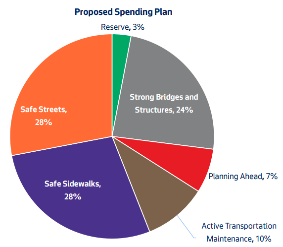
In budget discussions last year, a bloc of three councilmembers proposed allocating the entire amount toward bridge maintenance. A report from the city auditor had highlighted a spending gap on bridge maintenance funding: average spending on bridge maintenance of $6.6 million per year compared to a conservative estimate of $34 million per year. This plan would only spend around $2 million on bridge maintenance, in the “strong bridges and structures” category, which has been broadened to include stairways and other “essential roadway structures”. That’s approximately one-quarter of the revenue generated.
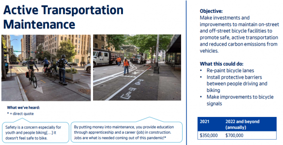
But a large percentage of the overall revenue is still earmarked for transportation maintenance. 28% of the revenue would go toward “safe sidewalks”, which includes restriping crosswalks, replacing crossing beacons, and repairing existing sidewalks. Money in this category would also be used to fund ADA curb ramps, which the city is under a court-mandated order to do. Another 10% would go to “active transportation maintenance”, which includes repainting bike lanes, upgrading barriers on protected lanes, and bike signal improvements.

Another 28% of revenue would be dedicated to safe streets through Vision Zero projects. Vision Zero projects run the gamut in scope, from spot improvements at a single intersection to protected bike lane installation on an entire corridor. The department was already on track to complete all of the VZ projects (12-15) that it promised to deliver with the Move Seattle levy, but the process for prioritizing those remains opaque and we’ve seen specific projects during the Durkan administration watered down.
Another 7% would be allocated to planning, which includes the development of a citywide multimodal plan. The city doesn’t lack in plans, just the vision to implement them and frequently (but not always) the funds to complete them. The details we’ve seen so far on the development of a citywide multimodal plan actually seem to get us farther away, with the bicycle master plan getting dismantled in the name of identifying “critical segments”.
3% of the funds would be kept in reserve, rounding out the entire pie.

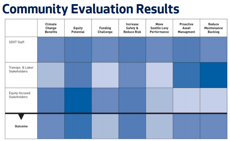
SDOT’s proposed breakdown of spending from the $20 VLF. How we got to this point is not completely clear. According to the results of SDOT’s outreach, the highest rated criteria for prioritization in the process was increasing equity in Seattle’s transportation system, with increasing safety close behind. While reducing the maintenance backlog was prioritized highly by stakeholders in the “transportation and labor” space, it didn’t come out on top when the results were weighted across the entire group of feedback providers. But equity and safety are core values at the Seattle Department of Transportation, as well as sustainability and mobility.

The results of the “community evaluation process” for the $20 VLF. (Click to enlarge) David Seater, former chair of the Pedestrian Advisory Board and a participant in the outreach process for this spending plan, told me that the public outreach was frustrating, particularly the idea of having to choose between safety and equity. “This process seems like a huge amount of overhead for what is a relatively small amount of money in the context of the SDOT budget. SDOT already has a huge, rigorously prioritized backlog of work and we should just be following that as more money becomes available”, he told me.
Ultimately the issue is that we’re trying to get too many things from one $20 vehicle license fee. If we need the entire amount here to fund bridge maintenance so we don’t have to spend more later, that doesn’t mean we shouldn’t push for other revenue sources to fund all of the other urgently needed priorities outlined in this spending plan. The size of the pie is a bigger issue than the individual slices.
SDOT has a survey on these spending categories through March 30th at 9am.
— Advertisement —
Construction starts on Uptown bike connection paired with Climate Pledge Arena
By
| Posted
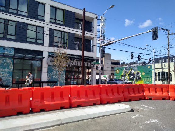
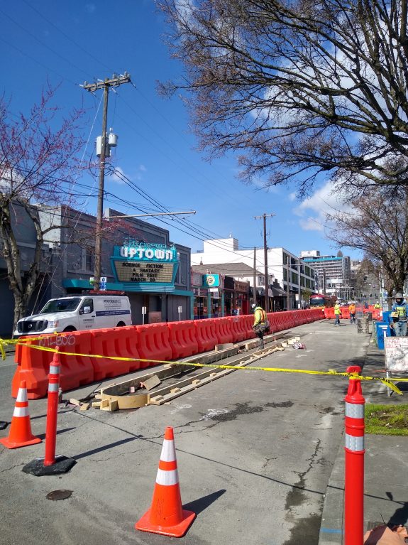
Construction work has started on a separated bike corridor in the Uptown neighborhood as part of a set of transportation projects required to be installed by the grand opening of former Key Arena, now Climate Pledge Arena. A grand opening date hasn’t yet been announced, but is still set for this fall.
First set of concrete curbs for the protected bike lane on Queen Anne Ave N near Mercer Street. 
Concrete curbs being installed near Republican Street on Queen Anne Ave N. The two-way cycletrack goes out of its way to accommodate traffic management for other types of travel in Uptown, with three blocks of Queen Anne Ave N getting bike lanes north of Thomas Street and two blocks of 1st Ave N south of Thomas. The current one-way bike lane on 1st Ave N that’s been in place for the construction of the arena will be gone by the time construction is complete.

Northern segment of the bike lane being installed in conjunction with the arena. (Click to enlarge) 
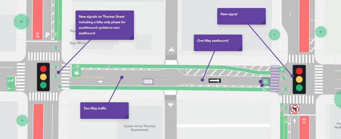
The planned connection between Queen Anne Ave N and 1st Ave N on Thomas Street. (Click to enlarge) 
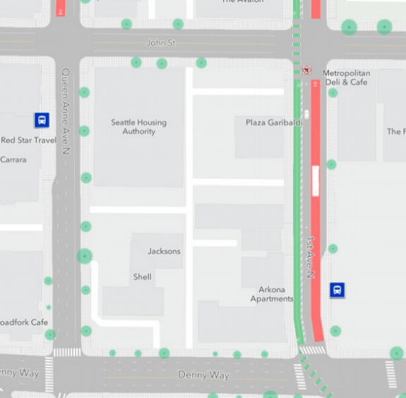
Southern segment of the Uptown bike lane on 1st Ave N north of Denny Way. North of Mercer Street, the plans fall outside the jurisdiction of the arena’s transportation agreement. The latest we saw for plans for the block between Mercer and Roy Street (where there are paint bike lanes) was a short stub of a bike lane for northbound riders that ends at the MarQueen Hotel’s load and unload zone.

Plans for the terminus of the bike lane for northbound riders north of Mercer Street. (Click to enlarge) The City is also working on connecting this Uptown cycletrack to the 2nd Ave protected bike lane via Broad Street this year. That lane will run along the western edge of 1st Ave and the northern edge of Broad Street.

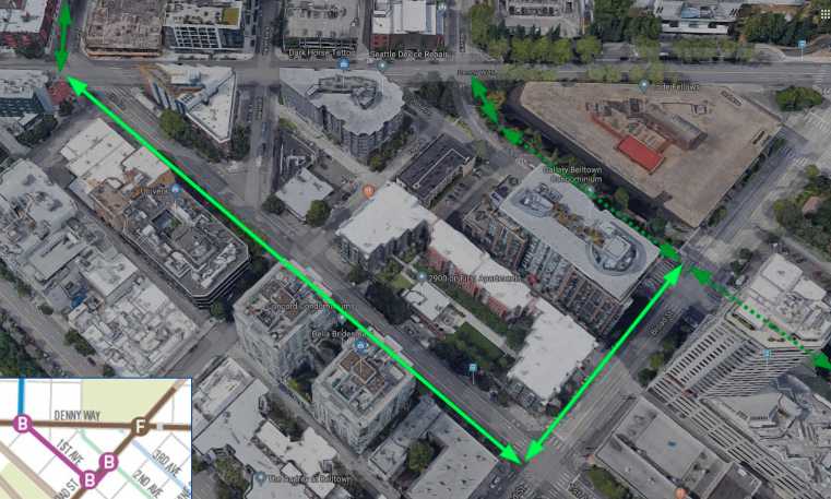
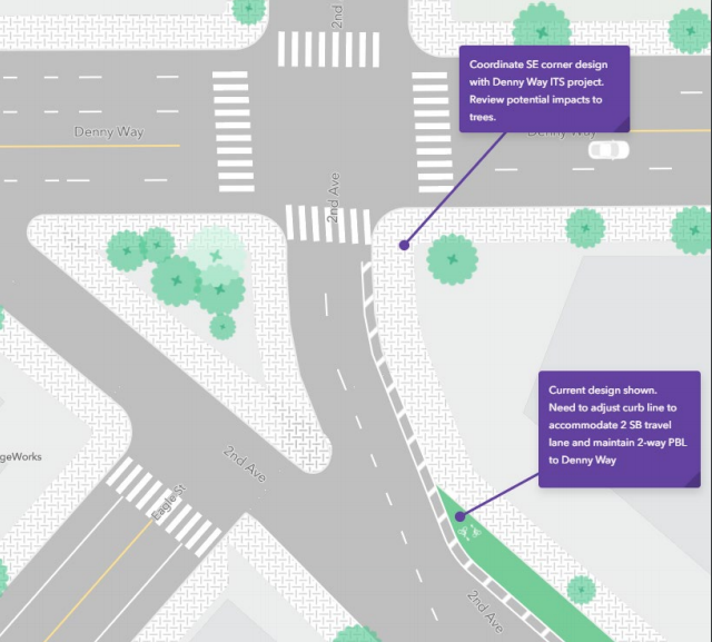
Location of the planned cycletrack connecting 1st and Denny with 2nd and Broad. (Click to enlarge) As for the northern end of the 2nd Ave protected bike lane, we don’t know exactly what the final design is going to look like yet. After negative reaction to the news that all bike traffic south of 2nd Ave and Denny Way would be relocated to the sidewalk, SDOT gave the intersection another look to improve the experience. A design shown last year (below) just shows a wider sidewalk.
The relocation of the bike lane here makes way for another southbound travel lane on 2nd Ave which will be the primary exit route for cars to “flush” out of the new 400-car garage at Climate Pledge Arena.

2020 illustration of 2nd Ave and Denny Way (Click to enlarge) Also planned this year is a big upgrade on the connection between Uptown and the Thomas Street bridge connecting the neighborhood with the Elliott Bay Trail.
Even though the arena is officially planning for a very small percentage of visitors to be arriving by bike (1% when it first opens), the street space being provided to give people a safe option to bike to Uptown for arena events might cause expectations to be exceeded. But more importantly it provides everyone in Seattle a way to access the neighborhood via a safe bike route.
— Advertisement —
Aurora Reimagined Coalition seeks to increase public pressure for safety improvements
By
| Posted
When the entirety of state route 99, Aurora Ave N, was repaved by the Washington State Department of Transportation in 2018 and 2019, many safety advocates saw a missed opportunity. While actual roadway is state-owned, Seattle is responsible for taking the lead on changes to the street like channelization and safety improvements. While spot improvements have happened along Aurora, there was not a comprehensive effort made to redesign one of Seattle’s most dangerous streets. As Bart Treece, communications manager at WSDOT, described it in 2019, “Ahead of this pavement preservation project, we did approach the city, but nothing materialized on their end.”
A new group calling itself the Aurora Reimagined Coalition seeks to ensure that opportunities like that aren’t passed up again. SDOT is set to receive a state grant funding a $2 million corridor plan. According to SDOT Director Sam Zimbabwe, the department expects to get to a 30% design on the entire Aurora corridor with this funding, and to a 90% design on at least one segment, setting the department up to be shovel-ready when funding becomes available to actually make changes. The coalition wants to ensure that someone is pushing SDOT to make Aurora into a “21st Century ‘main street’ for our neighborhoods, a thriving street where people feel comfortable walking and shopping and that reconnects neighborhoods on both sides of Aurora”. The group is having their kickoff meeting tonight.

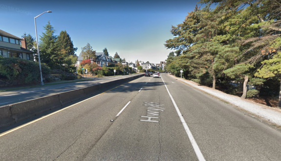
Aurora Ave N near Green Lake This month, SDOT announced that the first speed limit reductions on Aurora, a 30 mph limit between 85th and 109th Streets and a 35 mph limit between 115th St and the northern city limits at 145th Street, would be in place by mid-April. This is a slightly less significant change than we reported SDOT was requesting from WSDOT back in February, where the entire limit would be set at 30 north of 85th Street. Timelines for future phases in speed reductions, as suggested by SDOT’s proposal, remain unclear at this point. But Aurora will need significant changes to its design to make it as safe as it could be.
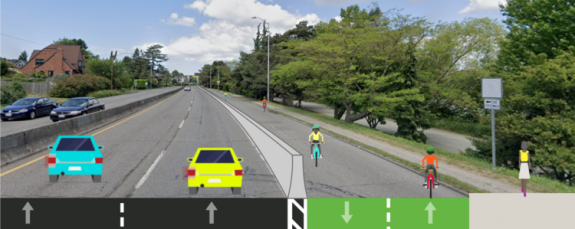
As a more immediate ask, the group is pushing for the curbside lane along Green Lake Park to be converted into walking and rolling space in place of the muddy dirt path (and no sidewalk) that currently exists there. Earlier this month, we reported on the fact that SDOT had already drawn up plans for this concept last Summer, and the department confirmed that it was still on the table but lacked funding, among other factors. With the soon-to-be completed protected bike lanes along the east side of Green Lake, adding a safe place to bike on the west side would complete a full route around Green Lake Park. They have a petition going to support this specific change.

Concept drawing for the Aurora lane conversion along Green Lake. (Green Lake & Wallingford Safe Streets) But the longer-term vision for comprehensive changes to Aurora looms large. In ten years, 22 people have been killed while trying to use Aurora Ave to get where they were going, the majority of them walking. Aurora is a public safety crisis that the City has evaded responsibility on for far too long.
The Coalition so far includes long-time advocates for safety on Aurora like Lee Bruch of Licton-Haller Greenways and Brock Howell & Tom Lang of Green Lake & Wallingford Safe Streets.
The Aurora Reimagined Coalition’s kickoff is tonight at 7pm, on Zoom. Click here for the Zoom meeting, or call (253) 215-8782, meeting ID 881 5043 1673.
— Advertisement —


Join the Seattle Bike Blog Supporters
As a supporter, you help power independent bike news in the Seattle area. Please consider supporting the site financially starting at $5 per month:
Latest stories
- Proposed 2025 Seattle budget shows why passing the transportation levy in November is so important

- Bike Portland answers my question: Where are the downtown Portland protected bike lanes?
- Everyone in the Puget Sound region should fill out this road safety plan survey
- Alert 9/28-29: Trail to Montlake Playfield and 520 Bridge Trail across Lake Washington closed
- Sunday: Cascade and SN Greenways will co-host free ride to promote November’s transportation levy
- Saturday: Foothills Trail bridge opens, connecting King and Pierce Counties across the White River


Latest on Mastodon